


1.0K Places to visit/vacation spots by kwhitfield
first prev 1 next lastThese are places that i want to hike/skate/etc.(Action things)

Hidden Valley Trails
Rexburg, Idaho
1.3 miles E of Rexburg, IdahoRight on the edges of town outside of the Hidden Valley subdivision, you'll find this fun little set of trails that's pretty good for mountain bikes. What was once just dirt roads and a dirt bike playground is now a fantastic mountain bike trail network.
West Side:
The West Side is what's commonly referred to as Hidden Valley Trails. It is a well-developed trail network with good signage and a few parking spots. It includes a variety of downhill trails and easy climbs, each between 0.3-0.4 mi long.
- High Road is a wide cut trail from old double track. Pretty straight with a few floater style roller jumps. It's also a popular climbing trail with a fairly gradual grade once you get past the climb at the start.
- Flow State is a meandering flow trail with several berms.
- Surge is a fairly straight shot jump line
- Sage Runner is a swoopy trail that mostly follows the contour of the hill with a little up around many of the turns. This trail is not heavily bermed.
- The Draw is a wide cut trail from old double track. Pretty straight with several large floater style roller jumps. It's also a popular climbing trail with a fairly gradual grade until you're almost to the top.
- Other trails:Rusty Ridge, The Drop Zone, Lil' Sendy, The Good, The Bad, The Ugly, Pulse, A-Fib, Neature Walk
East Side:
The East Side is undeveloped and does not have parking. It is often marked No Trespassing. Mostly, if you don't know, don't go.
- Hidden Valley Singletrack is a tight trail with tight corners and sagebrush closing it in even more. It's pretty rocky and has a couple small drops/rock-rolls. Janky describes it well. There are a few gap jumps that you'll need to find some speed for. There are a couple of off-shoots that will drop you right back down to the road to hit some of the bigger jumps below. There's an off-shoot at the end of the trail that you've got to take if you don't want to end up in the field but it's pretty clear where that is when you get to it.
- Dr. Jekyll is the road you climb up and as a climb, is pretty technical in places with some pretty tricky line choices through rocky sections. The ride down faces similar challenges through the rocky sections, except with gravity on your side. Visibility is much better on the road than in the sagebrush and there's considerably more flow and even some small rollers to jump.
PLEASE NOTE: This is private property that the owners are kind enough to permit use right now. Please respect their surrounding fields and stay on the trails that are already there. Please respect the residents near the trailhead and don't block driveways.

Murdy Skate park
Huntington Beach, California
4.0 miles N of Huntington Beach, California
Vans Off The Wall Skatepark
Huntington Beach, California
5.2 miles N of Huntington Beach, California
Oceanside Skate Park
Oceanside, California
2.7 miles NE of Oceanside, CaliforniaPark is wood on black top, worth checking out if you are in the area. Pads inforced righ next to beach.Courtesy of skatepark.com
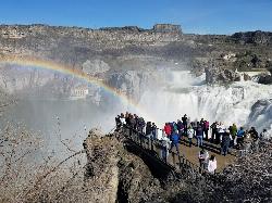
Shoshone Falls Park
Twin Falls, Idaho
3.7 miles NE of Twin Falls, IdahoThe view of Shoshone Falls is beautiful year round but it is simply breathtaking during spring runoff when the water levels are high and they roar so hard you can feel the mist hundreds of feet above the water. There are multiple platforms for viewing as well as information placards and a little gift stand. The park is owned and managed by the city of Twin Falls who charge a fee of $3 per carload (as of 4/1/2017).
The canyon rim trail goes up the canyon wall on the Southwest end of the falls and continues along the rim taking you to the site of Evel Kneival's 1974 attempt to jump the Snake River Canyon. To the jump site and back is about 2.5 miles round trip.

Bells Canyon
Sandy, Utah
1.9 miles E of Sandy, UtahBells Canyon is a moderate, 4.5 mile hike that begins in a residential area and ends at a waterfall in the enter of the canyon's forest. The first 1/2 mile of the hike is relatively easy and leads straight to the reservoir, which is one of the best views of the hike. There are several places for people to stop and have a snack surrounding the reservoir, although some choose to turn around before the trail gets too difficult.
Once you reach the sign that directs you to the waterfall, the hike gets considerably more difficult. It's about 1.2 miles of climbing over large rocks at a serious incline, but the views are incredible. Bells Canyon has gorgeous fall foliage in the autumn months, and once spring comes around, everything is beautiful and green. There is a creek that flows along the trail, several open areas of meadow and wildflowers, and spectacular views of the canyon and the Salt Lake Valley. It's a hike that pays off as you climb it.
The waterfall is in the center of a grove of trees. There is a steep hill downward that will take you to the base of the fall, but it can be treacherous to reach, so tread carefully.
Bells Canyon does not see much Mountain Bike traffic, and for good reason! It starts out very steep and with a loose gravel trail base, it makes for a tough climb on a bike. There are steps that are all but impossible to ride up (or down). After reaching the very scenic Lower Bells Canyon Reservoir the trail is much better! It turns to a fun single track through the trees. After crossing the stream above the Reservoir the trail becomes snarled with large granite boulders and is tough for even a hiker to negotiate. Courtesy of Singletracks.com

Chandler Skatepark
Chandler, Arizona
4.7 miles S of Chandler, Arizona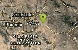
Superstition Shadow Skatepark
Apache Junction, Arizona
1.7 miles S of Apache Junction, Arizona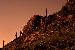
Piestewa Peak Summit Trail #300
Phoenix, Arizona
7.0 miles NE of Phoenix, ArizonaSome people still refer to the Peak by its original name of "Squaw Peak" before its name changed to "Piestewa Peak" in honor of Lori Piestewa who died serving her country in the Iraq conflict. The elevation of Piestewa is the second highest peak in Phoenix behind Camelback Mountain which is located nearby and features some difficult treks.Courtesy of arizona-leisure.com
The infamous Piestewa Peak Summit Trail is an out and back trail that rewards successful hikers with a three-hundred-sixty-degree view of the Phoenix metropolitan area. While short in length, a little over one mile, the trail is steep, jagged, and consists of multiple switchbacks and modified steps with integrated sections of gravel and rock. This summit trail has been a Phoenix favorite for several decades and is internationally recognized among hiking communities. Water, parking, and restrooms are available at the base of the trail.Courtesy of phoenix.gov
Although described as moderate to difficult, many kids and older adults do the Summit Trail. It's a climb all the way, and most areas have carved steps and there are two short segments with rails. It took us a little less than an hour to get to the top at a leisurely rate, frequently stopping to enjoy the scenery. If you plan to stay for the sunset, especially in winter months, it is suggested to take a flashlight as some areas become dark soon after sunset.Courtesy of hikingproject.com
The hike itself takes anywhere from 25 to 60 minutes in fair weather, depending on each hiker's capabilities (higher temperatures and sunny conditions may force the hiker to take up to twice as long). A beginning hiker should allow 60 minutes for a leisurely ascent and 40 for descent. The path is mostly well marked. There are 4 spots that are confusing and hikers who are not familiar with the path will be forced to look around for the designated route. There are a few sections that are technically difficult as they are steep and there are no guard rails.Courtesy of en.wikipedia.org


