


Bells Canyon
Sandy, Utah

| Address: | ~10200-10298 Grayboulder Ct, Sandy, UT 84092, USA |
| GPS: |
40°33'54.2"N 111°48'13.1"W Maps | Directions |
| State: | Utah |
| Trail Length: | 4.20 miles |
| MTB Difficulty: | Advanced |
| Trail Type: | Out & Back |
| MTB Trail Type: | Singletrack |
| Hike Difficulty: | Intermediate |
| Elevation Gain: | 1482 feet |
| Trails/Routes: | 1.1-4.7 mi |
Lakes Rivers Waterfalls Streams Trails Rocks Wildflowers Bicycles Fishing Restrooms National Park State Park
Backpack, Hike, Mountain Bike, and Snowshoe
Bells Canyon is a moderate, 4.5 mile hike that begins in a residential area and ends at a waterfall in the enter of the canyon's forest. The first 1/2 mile of the hike is relatively easy and leads straight to the reservoir, which is one of the best views of the hike. There are several places for people to stop and have a snack surrounding the reservoir, although some choose to turn around before the trail gets too difficult.
Once you reach the sign that directs you to the waterfall, the hike gets considerably more difficult. It's about 1.2 miles of climbing over large rocks at a serious incline, but the views are incredible. Bells Canyon has gorgeous fall foliage in the autumn months, and once spring comes around, everything is beautiful and green. There is a creek that flows along the trail, several open areas of meadow and wildflowers, and spectacular views of the canyon and the Salt Lake Valley. It's a hike that pays off as you climb it.
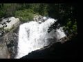
The waterfall is in the center of a grove of trees. There is a steep hill downward that will take you to the base of the fall, but it can be treacherous to reach, so tread carefully.
Bells Canyon does not see much Mountain Bike traffic, and for good reason! It starts out very steep and with a loose gravel trail base, it makes for a tough climb on a bike. There are steps that are all but impossible to ride up (or down). After reaching the very scenic Lower Bells Canyon Reservoir the trail is much better! It turns to a fun single track through the trees. After crossing the stream above the Reservoir the trail becomes snarled with large granite boulders and is tough for even a hiker to negotiate. Courtesy of Singletracks.com
More Information
Bell Canyon Trail (to first waterfall)
Popular for good reason. Head out early in the morning or on weekdays to avoid crowds. This hike runs up Bell Canyon, past a scenic reservoir, and up
https://www.utah.com/destinations/cities-towns/salt-lake-city/hiking/bell-canyon-trail-(to-first-waterfall)/Bells Canyon
Bells Canyon is a singletrack mountain bike trail in Salt Lake City, Utah. View maps, videos, photos, and reviews of Bells Canyon bike trail in Salt Lake City.
http://www.singletracks.com/bike-trails/bells-canyon/Never modify trail features. Ride trails when they're dry enough that you won't leave ruts. Speak up when you see others on the trail and always yield to hikers, horses, and others coming uphill. Always ride on the established trail.
Read MoreBe courteous, informed, and prepared. Read trailhead guidelines, stay on the trail, and don't feed the wildlife.
Read More- Plan Ahead and Prepare
- Travel & camp on durable surfaces
- Dispose of waste properly
- Leave what you find
- Minimize campfire impacts
- Respect wildlife
- Be considerate of other visitors
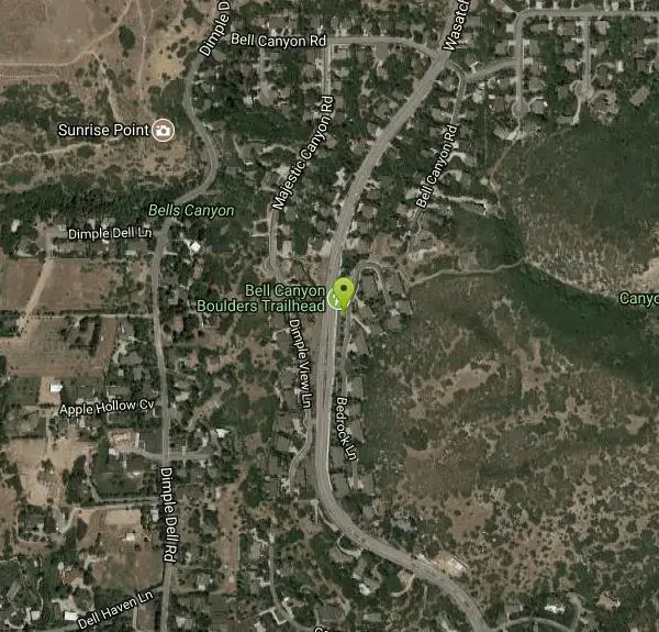
Directions
From Sandy, Utah
- Head east on E Sego Lily Dr toward S 1900 E (0.9 mi)
- Turn left onto S 2300 E/
Eastdell Dr (1.1 mi) - Turn right onto UT-209 E/
Little Cottonwood Rd (1.6 mi) - Turn right onto Wasatch Blvd (0.7 mi)
- Make a U-turn at Grayboulder Ct (187 ft)
- Turn rightDestination will be on the right(171 ft)
Granite Trailhead
From I-215 (Southbound)
Get off at exit 6 (6200 South) and head east. The road will curve south and become Wasatch Boulevard. Continue for 4 miles. At North Little Cottonwood Road, turn right to stay on Wasatch Boulevard. Go about one more mile until you reach South Little Cottonwood Road. Turn Left. The trailhead will be on your right.
I-15 (Northbound)
Exit at 12300 south (exit 291) Turn Right (east) and follow the road for 2.4 miles. It will curve North and turn into 1700 East. Turn right at the next light onto Wasatch Boulevard. Go east on Wasatch and follow it as it curves to the North. 7.6 miles from the freeway you will turn right onto South Little Cottonwood Road. It will be on the right.
Courtesy of summitpost.org
Boulder Trailhead
From I-215 (Southbound)
Get off at exit 6 (6200 South) and head east. The road will curve south and become Wasatch Boulevard. Continue for 4 miles. At North Little Cottonwood Road, turn right to stay on Wasatch Boulevard. Go a few more miles, passing South Little Cottonwood Road. The trailhead will be on your Left among some apartments (condos?). You may need to make a U-turn in order to reach it due to the median.
From I-15 (Northbound)
Exit at 12300 south (exit 291) Turn Right (east) and follow the road for 2.4 miles. It will curve North and turn into 1700 East. Turn right at the next light onto Wasatch Boulevard. Go east on Wasatch and follow it as it curves to the North. ~6 miles from the freeway it will be on the right, just off the road among some apartments (condos?).
Courtesy of summitpost.org
There is a parking lot just outside the trailhead at both the Boulder trailhead and the Granite trailhead, but there are limited spaces, so be prepared to park along Wasatch Boulevard.
 Bells Canyon Lower Falls October 2010 added by endovereric

 Bells Canyon Waterfall added by smbrady17


 Bells Canyon View 3 added by smbrady17
 Bells Canyon View 2 added by smbrady17
 Bells Canyon View added by smbrady17
 Bells Canyon Trail added by smbrady17
 Bells Canyon Greenery added by smbrady17
 Bells Canyon Lake 3 added by smbrady17
 Bells Canyon Lake 2 added by smbrady17
 Bells Canyon Lake added by smbrady17
 Bells Canyon Creek 2 added by smbrady17
 Bells Canyon Creek added by smbrady17

Other Mountain Bike Trails, Hiking Trails, Snowshoe Trails, and Backpacking Trails Nearby

Rocky Mouth Trail/Waterfalls
Sandy, Utah
1.3 miles SAn easy 0.2-mile stroll from suburbia reaches a scenic waterfall at the canyon mouth, while climbers can push deeper for 60-ft and 70-ft rappels through a slot canyon.
Canyoneer, Hike, Rock Climb 3.2 mi
Little Cottonwood Pipeline Trail
Sandy, Utah
1.6 miles EA single-track trail starting at the mouth of Little Cottonwood Canyon that stays smooth for the first mile, then gets rocky and steep — ending across a creek from historic ruins after 3.5 miles.
Mountain Bike 0.4 mi
Hidden Valley Park trail
Sandy, Utah
1.8 miles SA hidden shallow valley of grass, sandstone cliffs, and Navajo Sandstone domes just south of Moab — loop options total about one mile, but bring water because it gets hot.
Hike, Mountain Bike 0.2 mi
Orson Smith trail
Draper, Utah
3.1 miles SA short Draper foothills trail leading to a popular suspension bridge completed in 2015 at Bear Canyon — connecting to the Bonneville Shoreline Trail and open to hikers, bikers, and bird watchers.
Hike, Mountain Bike 0.7 mi
Great White Icicle
Sandy, Utah
3.2 miles EAn ice climb in winter and a waterfall rappel in summer just outside Salt Lake City — the Great White Icicle in Little Cottonwood Canyon offers four shelves of ice and a bucket-list 4-to-5-hour ascent for all seasons.
Hike, Rock Climb
Ferguson Canyon
Cottonwood Heights, Utah
3.3 miles NA popular climbing destination tucked between Big and Little Cottonwood Canyons, where you can hike into a shaded canyon with a stream or push on to a rocky summit for sweeping views.
Hike, Mountain Bike, Rock Climb 0.8 mi
Bear Canyon Suspension Bridge
Draper, Utah
3.4 miles SWA 4.5-mile moderate hike in Draper connecting to a 185-foot suspension bridge over Bear Canyon, with sweeping Salt Lake Valley views and dozens of additional trails branching off nearby.
Hike, Mountain Bike 0.5 mi
Draper City Park
Draper, Utah
3.9 miles SWA spacious Draper city park near the Porter Rockwell and Willow Creek trailheads, featuring two lighted pavilions, four baseball fields, playgrounds, and a famous central willow 'Tree of Life.'
Hike
Lisa Falls
Sandy, Utah
4.1 miles EA shaded granite climbing area in Little Cottonwood Canyon with polished friction faces, clean cracks, juggy overhangs, and a roaring waterfall that keeps the atmosphere cool and energizing.
Hike, Rock Climb 0.6 mi
Bst To Equestrian Center Loop
Draper, Utah
4.7 miles SWA 10-mile intermediate singletrack loop in Draper connecting the Bonneville Shoreline Trail and Equestrian Center with 417 feet of elevation along varied terrain.
Hike, Mountain Bike 1.6 mi
Corner Canyon Trail
Draper, Utah
4.7 miles SWA go-to mountain biking area in South Salt Lake mixing beginner training trails in Little Valley with big table tops and wall rides in Maple Hollow.
Backpack, Hike, Mountain Bike 1.2 mi
Ghost Falls Trail
Sandy, Utah
4.9 miles SA family-friendly hike in Corner Canyon that winds through sandy rocky slopes and dry creek beds to the Ghost Falls loop, with helpful trail signs at the confusing intersections.
Hike, Mountain Bike, Snowshoe 0.2-1.8 mi
Lone Peak
Draper, Utah
4.9 miles SOne of the Wasatch Front's taller peaks at over 11,000 feet, Lone Peak offers five different trailhead approaches, a 9-mile average round trip, rugged canyon terrain, and stunning Salt Lake valley views.
Hike, Mountain Bike, Rock Climb 1.7 mi
Jacob's Ladder Trail
Sandy, Utah
4.9 miles SJacob's Ladder is the steep, relentless local favorite for climbing into the Lone Peak Wilderness above Draper, Utah — and a legendary technical descent.
Hike, Mountain Bike
Storm Mountain
Salt Lake City, Utah
5.1 miles NEA compact Wasatch peak just 3 miles up Big Cottonwood Canyon, with rock climbing routes, hiking, biking, and Big Cottonwood Creek running right alongside the day-use area.
Hike, Mountain Bike, Rock Climb 0.6 mi
Potato Hill Trail
Draper, Utah
5.8 miles SWA short, paved trail system in Draper that connects Potato Hill to the Bonneville Shoreline Trail — combine with Red Potato and Lexie and Ethan trails for a 3-mile loop with smooth climbing.
Hike, Mountain Bike
Little Valley Trail
Draper, Utah
5.9 miles SWSuperbly constructed flow trails in a small Draper valley that are just as fun for adults as for kids — with connections to Corner Canyon for a longer ride.
Hike, Mountain Bike
Pete's Rock
Salt Lake City, Utah
6.1 miles NA large roadside rock next to the Mount Olympus trailhead — a local favorite for casual rock climbing, with the 9,026-ft summit offering some of the best views in the Salt Lake Valley.
Hike, Rock Climb
Mercer Hollow Trail
Draper, Utah
6.1 miles SA fast, flowy descent on the southern flank of Corner Canyon Ridge, packed with berms, rock features, rollers, and a quick uphill that rewards you on the way back down.
Hike, Mountain Bike 0.8 mi
Red Rock Trail
Draper, Utah
6.1 miles SWA one-mile cliff-edge loop delivers sweeping Salt Lake Valley views and beginner-to-intermediate rock climbing on five walls with dental-themed route names.
Hike, Mountain Bike, Rock ClimbNearby Campsites

Spruces Campground
Salt Lake City, Utah
10.1 miles NEA fee campground in Big Cottonwood Canyon near Salt Lake City — check USDA.gov for current rates and seasonal availability.
Camp, Sled
Mill Creek Canyon
Salt Lake City, Utah
10.4 miles NEAn out-and-back canyon trail with over 1,000 feet of elevation gain — the lower ski trail sees heavy traffic while the upper section above Elbow Fork stays quiet, with a reservable Yurt at the top December through April.
Camp, Cross-country Ski, Snowshoe 1.6-14.1 mi
Mount Timpanogas
Provo, Utah
12.7 miles SEUtah's most-climbed mountain towers 7,000 feet above the Provo valley, stretching seven miles north to south with multiple peaks over 11,000 feet — a Wasatch landmark.
Camp, Hike, Horseback, Swim
Holbrook Trailhead
Bountiful, Utah
22.0 miles NThe Holbrook Trailhead is a popular access point for the Bonneville Shoreline Trail and Holbrook Canyon above Bountiful, Utah, on the western face of the Wasatch. Perched on the bench right at the...
Airsoft, Backpack, Camp, Paintball, Snowshoe
Y-Mountain Summit Trail
Provo, Utah
24.4 miles SEA 1.2-mile climb east of BYU leads to a massive block Y on the hillside and sweeping panoramas over Provo, Orem, Utah Valley, and Utah Lake below.
Camp, Hike 5.6 mi
Antelope Island Lakeside Trail
Syracuse, Utah
39.1 miles NWAn easy 2-hour loop on Antelope Island around the Great Salt Lake, with rock formations, views of the Sierra Nevadas, and the GSL — kid-friendly and good for bug fans.
Camp, Hike, Horseback
Antelope Island State Park
Syracuse, Utah
39.3 miles NWTwenty miles of trails cross Utah's Great Salt Lake island alongside free-roaming bison, antelope, and bobcats — best visited in early spring or late fall to beat the bugs.
Backpack, Camp, Hike, Horseback, Mountain Bike 4.7 mi
Fifth Water Hot Springs
Provo, Utah
40.8 miles SEA scenic 2.5-mile riverside hike to the famous Diamond Fork rock pools and waterfall, with soaks up to 108°.
Backpack, Camp, Hike, Hot Springs, Mountain Bike, Swim


