


942 Bucket List by smbrady17
first prev 1 next last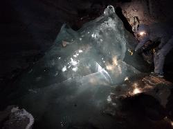
Rexburg Area Ice Caves
Rexburg, Idaho
29.1 miles N of Rexburg, IdahoNot to be mistaken with the Civil Defense Caves (which are near by), the Ice Caves are about an hour North outside of Rexburg. The Ice Caves were originally formed as lava tubes. The shape of the caves traps cold winter air in the cave and forms large areas of ice on the floor and beautiful ice crystals on the walls and ceiling. The ice remains frozen year round and makes for an awesome time. The ice caves are a few hundred yards deep and require good footwear, warm clothes and a flashlight to navigate. There is often a good amount of water near the entrance. There's a bridge of rocks across the area but you may get a little wet getting in the cave. There are areas where you'll need a rope to be able to ascend portions of ice. Please do not light fires or introduce any other heat source into the caves.
Bear Creek Hot Springs
Irwin, Idaho
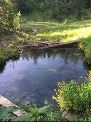
9.8 miles S of Irwin, IdahoBear Creek Hot Springs is one of eastern Idaho's most rewarding backcountry soaks — a natural rock pool hidden deep in the Caribou-Targhee National Forest, reached only on foot, by bike, or on horseback up a long and beautiful canyon. It sits near Irwin, just south of Palisades Reservoir on the Idaho–Wyoming line, and it's the kind of place you have to earn: roughly 13 miles round trip, which is exactly why the people who make it tend to have the pool to themselves.
The good news is that most of that distance is gentle. From the trailhead the route follows Bear Creek up a green, forested canyon under lodgepole and aspen, rolling along at an easy grade with the water always close by. Wildflowers fill the meadows in early summer, and thanks to newer bridges and dry bench paths you can now keep your feet out of the water and skip the old creek crossings (in spring runoff those fords ran high, so the dry routes are a welcome upgrade). It's pretty, low-effort walking for miles.
Then comes the part everyone remembers. The final stretch climbs hard — close to a thousand feet in the last mile — so save your energy for that last push and fill your water bottles before you start up. The reward is immediate: a clear natural pool, roughly 10 by 20 feet, sitting at just about the perfect soaking temperature after all that trail. Tucked this far back in the wilderness, it's quiet, private, and worth every step. One honest heads-up before you bring the family: the soak is frequently clothing-optional.
This is true backcountry, and it's a favorite across the board — hikers and backpackers come for the soak, mountain bikers ride the intermediate singletrack with its fun, branching loop options, and horseback riders share the same trail. Many turn the trip into an overnight, camping in the backcountry to enjoy a quiet, starlit soak before hiking out in the morning.
Come prepared for a remote mountain trip: pack plenty of water and plan to filter from the creek, bring bug repellent in early summer, and carry bear spray, since this is bear country and sightings are common. The trailhead has a parking area and a restroom, but no services beyond that, and there's no cell coverage once you're in the canyon — so let someone know your plan and give yourself plenty of daylight for the round trip. The trail is at its best from late spring through fall, roughly March into October, when the canyon is green and the water is just right. Few places in the region pay you back like Bear Creek does.
Yellowstone Branch Line Trail
Ashton, Idaho
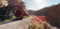
7.6 miles NE of Ashton, IdahoYellowstone branch line trail runs from Warm River to the Montana border totaling 39 miles. There are a few places to jump on and off the trail as well as a few smaller trails that branch off of this larger trail. A lot of the traffic covers small portions of this trail so not many people tackle the trail in its entirety. The trail offers a variety of different activities. It is open for backpacking, hiking, mountain biking, horseback riding, and all terrain vehicles under a certain size. Depending on what you want to spend your day doing it’s a good idea to plan accordingly.
Also known as The Great Western Trail of Idaho, The Warm River Rail Trail, Route of the Yellowstone Special, or the northern portion of the Yellowstone Grand Teton Rail Trail.
Fall River Bridge
Ashton, Idaho
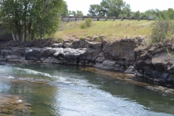
6.6 miles SW of Ashton, IdahoRight off Highway 20, there's a great spot to swim, swing, and dive. There's pullouts for parking right next to the bridge. There's a rope swing under the railroad bridge and a little swimming hole to the North. As always be careful of water levels. There are rocks down the middle of the river on the North side. If they're covered, the water is high.

Henry's Fork Green Way (St. Anthony Green Belt)
Saint Anthony, Idaho
0.6 miles SW of Saint Anthony, IdahoThis is a great walk along the river. While it is nestled right next to the highway, the closeness and beauty of the river flowing on the other side of the trail more than make up for it. Halfway along the trail, there's a statue of Andrew Henry and a loop that will take you right back for an easy 1 mile. The full length is a mile itself making a full 2 mile round trip.
Pet Friendly: Yes
Difficulty: Easy
Trail: Paved
Length:
- Statue Loop: 1 mile
- Full Round Trip: 2 miles


