


Baypoint Beach
Rochester

Canoe, Hike, Kayak, and Swim
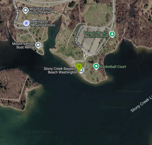
Baypoint Beach is one of two designated swimming beaches on Stony Creek Lake in Stony Creek Metropark, a Huron-Clinton Metroparks property northeast of Rochester. The beach sits on the west side of the 500-acre lake, a reservoir formed by damming Stony Creek, a tributary of the Clinton River. Although the park's mailing address is in Shelby Township, the beach itself lies in Washington Township in Macomb County. Eastwood Beach, the busier of the two, is directly across the water to the southeast.
Drive in through the main entrance at 4300 Main Park Road and follow Park Road around the lake to the Baypoint Beach lot, which has van-accessible spaces connected to the beach by a concrete walkway. The paved 6.1-mile Hike-Bike Trail that loops the lake passes just above the beach, and anyone arriving on foot, by bike or on skates through the park roads or that trail gets in free.
The swim area is a narrow strip of sand facing southwest into a sheltered arm of the lake, with some shade trees behind it and a mat that runs across the sand to the water's edge. This is a still, inland reservoir, so there is no current to speak of, and Macomb County sampling records show the water near the beach typically reaches the mid to upper 70s Fahrenheit by July. There are no lifeguards at either Stony Creek beach, and the Metroparks post it plainly as swim at your own risk. Free loaner life jackets for kids and adults hang at a station at the beach on a first come, first served basis. Swimming is only allowed inside the posted swim areas, and boats are kept out of them.
Entry is by vehicle pass, not a beach fee. A daily pass is $10 per vehicle. An annual pass is $40 for residents of Livingston, Macomb, Oakland, Washtenaw and Wayne counties and $45 for everyone else, with senior rates of $29 and $34, and it covers all 13 Metroparks. A Michigan Recreation Passport does not get you in. The park is open 6 a.m. to 10 p.m., and the beaches are open daily from 8 a.m. to 8 p.m. between May 1 and October 1.
The Macomb County Health Department tests the water at Baypoint for E. coli twice a week from April through September and closes the beach when a result goes over the state's body-contact standard. Past sampling shows counts tend to climb in late summer, so check the county's beach status page or Michigan's BeachGuard map before you go, especially after heavy rain. Pets are not allowed at the beach, and fires, alcohol and glass containers are banned. Shade canopies are fine but tents with sides are not.
Next to the beach is a restroom building with men's, women's and family changing rooms, plus an outdoor shower and foot wash. A picnic shelter, a playground, a basketball court and a sand volleyball court are all within a short walk, and the Mount Vernon picnic area just west of the beach has boat rentals in season, including kayaks, rowboats and paddleboats. If you want a concession stand or the inflatable water slide, those are at Eastwood Beach across the lake.
More Information
Bathing beach monitoring
Bathing beach monitoring
https://www.macombgov.org/departments/health-department/bathing-beach-monitoringBe courteous, informed, and prepared. Read trailhead guidelines, stay on the trail, and don't feed the wildlife.
Read More
- Plan Ahead and Prepare
- Travel & camp on durable surfaces
- Dispose of waste properly
- Leave what you find
- Minimize campfire impacts
- Respect wildlife
- Be considerate of other visitors
Directions
From Rochester
- Head south on South Ave (0.1 mi)
- Turn right onto NY-31 W/
E Broad St (0.4 mi) - Turn right onto S Plymouth Ave (0.3 mi)
- Turn left to merge onto I-490 W (4.9 mi)
- Keep left to stay on I-490 W (17.5 mi)
- Take the exit onto I-90 W toward BuffaloToll road(41.5 mi)
- Take exit 50 toward I-290/
Niagara Fls Toll road(0.4 mi) - Continue onto I-290 W (9.5 mi)
- Take the exit onto I-190 N toward Niagara FallsToll roadEntering Canada (Ontario)(15.1 mi)
- Continue onto ON-405 WToll road(5.9 mi)
- Merge onto Queen Elizabeth Wy (30.8 mi)
- Take the Red Hill Valley Pkwy exit toward Airport (1.3 mi)
- Continue onto Red Hl Vly Pkwy (4.3 mi)
- Continue onto Lincoln M. Alexander Pkwy W (7.1 mi)
- Take the exit toward ON-403 W (0.1 mi)
- Slight left to merge onto ON-403 W toward Airport/
Brantford/ Hamilton Airport (41.0 mi) - Merge onto ON-401 W (31.0 mi)
- Keep right to continue on ON-402 W, follow signs for SarniaToll road(63.6 mi)
- Continue onto Blue Water Brg WToll roadEntering the United States of America (Michigan)(0.6 mi)
- Continue onto I-69/
Blue Water Brg W Toll road(0.8 mi) - Keep left to continue on I-69/
I-94 W, follow signs for Detroit/ Flint/ Lansing Continue to follow I-94 WToll road(26.3 mi) - Take exit 248 for 26 Mile Rd toward Marine City (0.4 mi)
- Turn right onto 26 Mile Rd (13.6 mi)
- At the traffic circle, continue straight to stay on 26 Mile Rd (0.2 mi)
- At the traffic circle, take the 1st exit and stay on 26 Mile Rd (1.9 mi)
- Turn left onto Main Park Dr (0.4 mi)
- Continue onto Park Rd (0.8 mi)
- Keep right to stay on Park Rd (2.8 mi)
- Turn left toward Baypoint Beach Dr (220 ft)
- Continue onto Baypoint Beach Dr (0.1 mi)
- Turn leftPartial restricted usage road(0.2 mi)


Other Swimming Holes, Hiking Trails, Canoeing Areas, and Kayaking Areas Nearby
Belle Isle Beach
Detroit
27.1 miles SA half mile of Detroit River sand on a state-run island park between Detroit and Windsor, with a buoyed swim area open Memorial Day through Labor Day. No lifeguards, a three mile an hour river past the buoys, and periodic E. coli closures.
Canoe, Hike, Kayak, Swim
Palmer Park
Saint Clair, Michigan
31.4 miles ESwim near Saint Clair, Michigan
Swim
Lexington Beach
Lexington
47.1 miles NEThe Village of Lexington's free public swim beach on Lake Huron, a long sand shore running north from the state harbor breakwall in Michigan's Thumb. No lifeguard, and the county health department samples the water weekly all summer.
Kayak, Swim


