


Crow Butte Park
Paterson
Camp, Canoe, Hike, Kayak, and Swim
Crow Butte Park is a day-use area, marina and campground on Crow Butte Island in Lake Umatilla, the pool of the Columbia River held back by John Day Dam, in Benton County about 12 miles west of Paterson. The U.S. Army Corps of Engineers owns the land and built the park in the 1970s. Washington State Parks ran it as a state park from 1977 to 2002, and since August 2007 the Port of Benton, a public port district, has operated it under an agreement with the Corps. The island was a hill on the riverbank until the reservoir filled around it, and a causeway now links it to the Washington shore.
The entrance is off State Route 14 (the Lewis and Clark Trail Highway) at milepost 155, and the park address is 165215 W. Crow Butte Road, Paterson. The entrance road passes under an overpass marked at 14 feet 3 inches, worth knowing if you drive a tall RV. Crow Butte Road crosses to the island and runs past the contact station and marina to the grassy day-use area on the west side, which has its own parking lot beside the playground and picnic shelters. Plan on about 18 minutes from Paterson, 40 from Hermiston, Oregon, and an hour from the Tri-Cities.
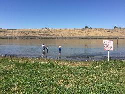
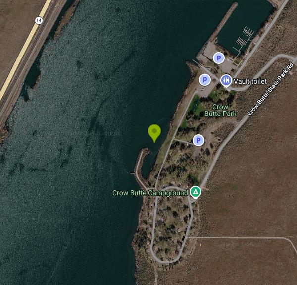
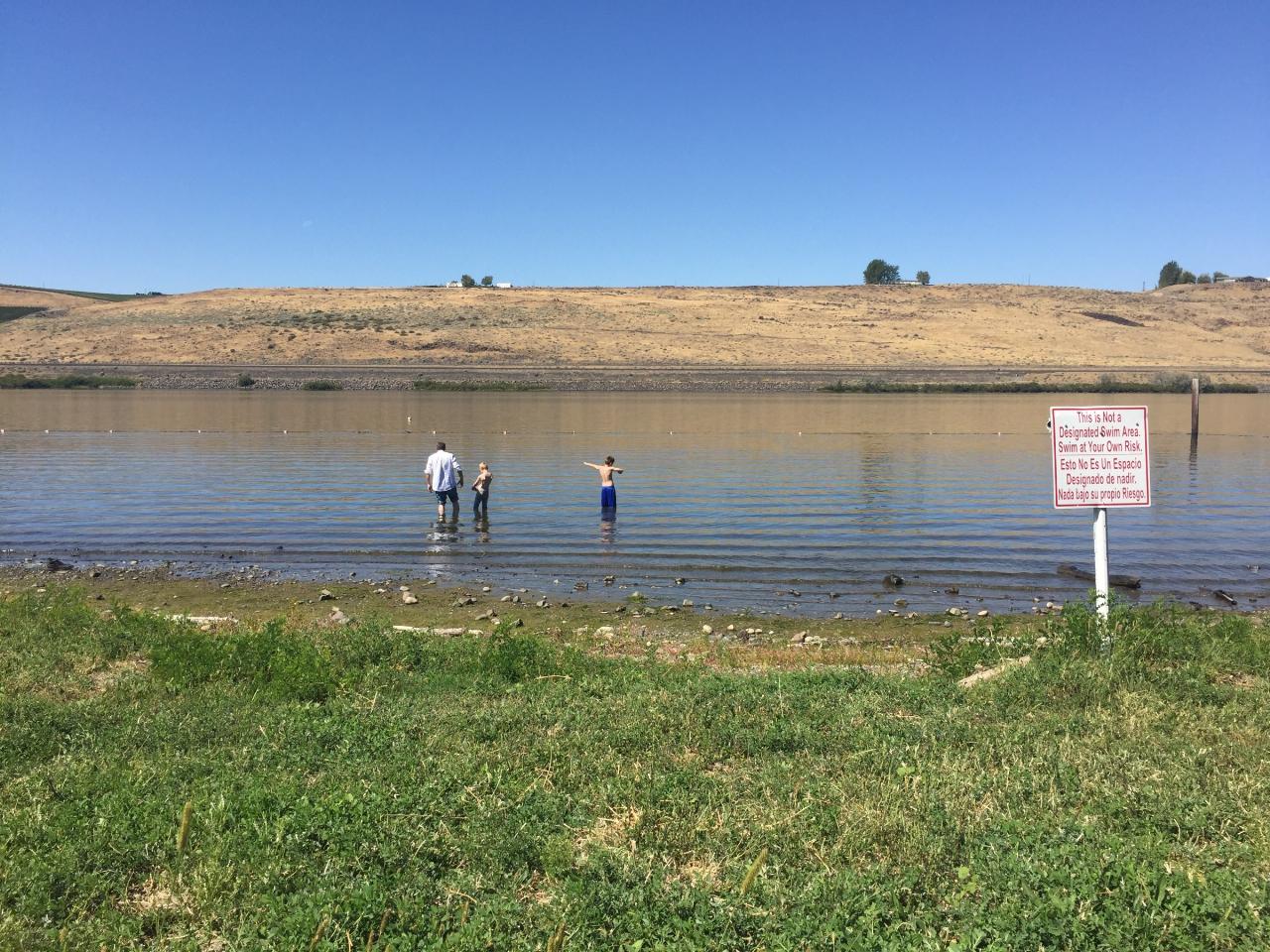
The swim area is a short stretch of shoreline along the day-use lawn, just west of the playground and group shelter, facing the quiet channel between the island and the mainland. It is not a guarded beach. No lifeguards are on duty, and a sign at the water's edge has stated that this is not a designated swim area and that people swim at their own risk. Near shore the bottom is gravel and cobble that slopes gently, so kids can wade, but the reservoir gets deep farther out. This is the Columbia itself: the current is slow in the pool, but afternoon wind can raise chop and push inflatables offshore, and the reservoir level moves with dam operations, changing how much beach is exposed. The water is warmest in July and August. Pets are not allowed in the beach area, and glass bottles and metal cans are banned on the beach and playground.
Crow Butte Park is not free. Day visitors need a Day-Use/Marina Parking Pass, $10 per vehicle per day, or an annual day-use and marina parking pass for $60; both prices include Washington sales tax. Passes can be bought ahead online through crowbutte.com or at the park. A Discover Pass does not apply, since this is no longer a state park. The park season runs April 1 to October 15, day-use hours are dawn to dusk, and the day-use area closes at dusk. The boat ramp stays open all year.
The park covers about 275 acres with six miles of shoreline. Boats launch at the marina just north of the swim area, so keep swimmers clear of the ramp, docks and boat channel. Beyond the beach there is a full-hookup campground ($45 a night, $35 for veterans), a primitive group camp, a marina with day and overnight moorage, restrooms with showers, a group pavilion, walking and bike paths, and trails over the butte with views along the river. A snack bar opens Thursday through Sunday from Memorial Day to Labor Day. The island sits on the Northwest Discovery Water Trail, a Columbia paddling route, and borders part of the Umatilla National Wildlife Refuge, good for shorebirds and migrating waterfowl. Dogs must be leashed.
More Information
Activities and Amenities - Crow Butte Park
The majestic Columbia River is the focal point of Crow Butte Park. This popular camping and recreational destination is nestled within mature shade trees on the 1,500-acre Crow Butte Island in Benton County. The island is situated along the Northwest Discovery Water Trail, traveled by explorers Lewis & Clark. The area is also adjacent to a portion of the Umatilla National Wildlife Refuge, where shorebirds, songbirds and migratory waterfowl congregate.
https://crowbutte.com/activities-and-amenities/Crow Butte Park - Lewis and Clark Trail Experience
Crow Butte Park offers a year-round boat ramp, seasonal camping with pull-through and back-in, full hookup 50amp sites.
https://lewisandclark.travel/listing/crow-butte-parkCrow Butte Park Launches 2021 Season With Contactless Reservations and Parking Passes - Port of Bent
Richland, Wash. – Port of Benton recently launched a new website for its Crow Butte Park in Paterson, crowbutte.com. For the first time, visitors can pay for
https://www.portofbenton.com/crow-butte-park/Crow Butte ready to welcome campers – when Phase 2 comes | Tri-Cities Area Journal of Business
One good thing happened when Crow Butte Park in southern Benton County closed to campers because of the Covid-19 crisis.No one was camping in early June when a storm blew through. Lightning struck an irrigation pump and 14 large trees blew down in the campground.Normally, all 52 campsites would have...
https://www.tricitiesbusinessnews.com/articles/2781FAQ - Crow Butte Park
Making a reservation online is quick and easy! Follow these tips to help guide your experience.
https://crowbutte.com/faq/Fees and Rules - Crow Butte Park
Camping reservations, day use and marina parking passes are payable in full when making your reservation or purchasing passes. All fees include Washington
https://crowbutte.com/fees-and-rules/History of Crow Butte - Crow Butte Park
The U.S. Corps of Engineers developed Crow Butte Park in the ‘70s as part of the McNary Dam project. The Corps then transferred the Park to Washington state
https://crowbutte.com/history-of-crow-butte/Map and Directions - Crow Butte Park
The 275-acre park is 12 miles west of Paterson, Washington, on Highway 14.
https://crowbutte.com/map-and-directions/Be courteous, informed, and prepared. Read trailhead guidelines, stay on the trail, and don't feed the wildlife.
Read More
- Plan Ahead and Prepare
- Travel & camp on durable surfaces
- Dispose of waste properly
- Leave what you find
- Minimize campfire impacts
- Respect wildlife
- Be considerate of other visitors
Directions
From Paterson
- Head south on Main St toward Main St (0.5 mi)
- Turn right onto Grand St (0.2 mi)
- Turn left to merge onto I-80 W (11.9 mi)
- Keep left to stay on I-80 W, follow signs for Netcong/
Del Water Gap Toll roadEntering Pennsylvania(46.5 mi) - Keep left to stay on I-80 WToll road(0.3 mi)
- Keep left to stay on I-80 WToll road(2.0 mi)
- Take the exit toward I-80 W (0.5 mi)
- Slight left to merge onto I-80 W (227 mi)
- Slight left (2.1 mi)
- Merge onto I-80 W (22.6 mi)
- Slight left (2.0 mi)
- Merge onto I-80 WEntering Ohio(71.4 mi)
- Take the exit to stay on I-80 WToll road(215 mi)
- Keep left to continue on I-80 W/
I-90 W Toll roadEntering Indiana(139 mi) - Take exit 21 for I-80 W/
I-94 W toward IN-51 S (0.9 mi) - Merge onto I-94 W/
I 80 E Continue to follow I-80 WToll roadEntering Illinois(22.8 mi) - Keep right to stay on I-80 W, follow signs for IowaToll road(24.3 mi)
- Slight left (0.6 mi)
- Continue straight (2.8 mi)
- Keep left (1.6 mi)
- Keep left (0.2 mi)
- Continue straight (1.3 mi)
- Merge onto I-80 W (114 mi)
- Keep left to continue on I-280 WEntering Iowa(27.2 mi)
- Take the exit onto I-80 W/
US-6 W Continue to follow I-80 W(166 mi) - Keep right to stay on I-80 W, follow signs for Council Bluffs/
Omaha Parts of this road may be closed at certain times or daysPassing through Nebraska, WyomingEntering Utah(1,008 mi) - Take exit 168 for I-84 W toward Ogden (0.3 mi)
- Continue onto I-84 W (38.5 mi)
- Merge onto I-15 N/
I-84 W (38.7 mi) - Keep left to continue on I-84 W, follow signs for BoisePassing through IdahoEntering Oregon(515 mi)
- Take exit 179 for I-82 W toward Umatilla/
Kennewick (0.5 mi) - Continue onto I-82 WEntering Washington(11.1 mi)
- Take exit 131 for WA-14 W toward Plymouth/
Vancouver (0.3 mi) - Turn left onto WA-14 W (25.8 mi)
- Turn right onto Sonova Rd (148 ft)
- Turn right onto W Crow Butte Rd (0.2 mi)
- W Crow Butte Rd turns slightly right and becomes Crow Butte State Park Rd (1.7 mi)
- Turn right (453 ft)
- Slight right (131 ft)


Other Swimming Holes, Hiking Trails, Canoeing Areas, and Kayaking Areas Nearby
Sacajawea Historical State Park
Pasco, Washington
45.7 miles NEA sandy swim beach at the confluence of the Snake and Columbia rivers in Pasco, on the site where Lewis and Clark camped in October 1805.
Canoe, Hike, Kayak, Swim
Hood Park
Burbank
47.1 miles NEHood Park is a free Army Corps of Engineers day-use area and campground on the Snake River (Lake Wallula) at Burbank, Washington, with a sheltered sandy swim beach open May through Labor Day.
Camp, Hike, Kayak, Swim


