


Fish Lake Valley Hot Well
Dyer

Camp and Swim
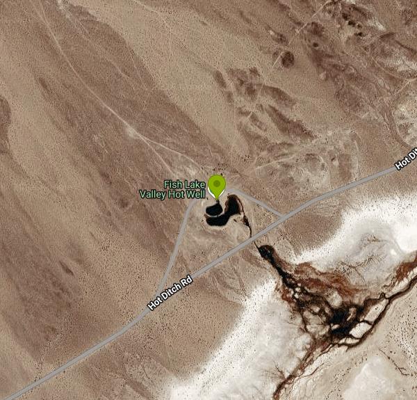
Fish Lake Valley Hot Well (also called Fish Lake Valley Hot Springs or Fish Lake Hot Well) is a developed geothermal soak in the open sagebrush of Fish Lake Valley, Esmeralda County, Nevada, about 14 miles north of the small community of Dyer. Travel Nevada, the state tourism office, lists it as managed by Esmeralda County and free and open to the public. The water comes from an old artesian well, usually credited to ranchers drilling in the 1880s, that puts out roughly 50 gallons per minute. From the tub you look west across the valley to the White Mountains and 13,147-foot Boundary Peak, the highest point in Nevada.
There's no paved access. From the junction of State Routes 264 and 773 at the north end of the valley, drive south on SR 264 for just under 6 miles and turn east onto a graded dirt road. Follow it about 7 miles; the vault toilet and a wide gravel flat mark the spot. Travel Nevada puts the drive at about 20 minutes from Dyer, or a bit over an hour from Tonopah on dirt and gravel mining roads. Most cars make it in dry weather, though the road is known for heavy washboard, and it can turn impassable when wet or snowy. GPS routing out here is unreliable, and most carriers have no signal at the springs.
The soak itself is a below-ground concrete tub, roughly 12 by 6 feet and 3 to 4 feet deep, with a gravel bottom, handrails and a low cinder-block wall around a concrete deck. The tub usually holds 104 to 105 degrees, shifting a little with season and air temperature, so test it before getting in. Its overflow runs down a short bank into a warm pond, and from there into larger, cooler ponds ringed by marsh plants. The first pond is the one people swim in on hot days. Expect a soft, deep mud bottom that will grab your shoes. Nobody staffs the site and there are no lifeguards. It's open year-round, 24 hours, with no entry fee, no reservations and no day-use charge of any kind.
Facilities are basic: one vault toilet, trash barrels, a few fire rings and barbecue grills, and an outdoor sink fed by the hot well that is signed as not fit for drinking or cooking. Bring all the water you'll need. The county has put up barriers to keep vehicles and tents back from the tub, and visitors are asked to camp at least 100 feet from the spring. Swimsuits are a good idea; the site sees steady use, especially on spring and fall weekends, when the ATV and dirt-bike crowd fills the flats.
A sign at the tub warns that the county will close and fill in the facility if vandalism and the killing of wildlife continue, so take that seriously. The ponds hold large goldfish, coots and ducks, and other animals come in to drink. Leave them alone. In 2025 one visitor reported geothermal drilling rigs working in the area with noise late at night, though a July 2026 report described the site as open and the road freshly graded. Summer afternoons are brutally hot for a 105-degree soak; late spring and fall are more comfortable.
Free dispersed camping surrounds the hot well on a flat, open gravel area big enough for large RVs and trailers. The nights are some of the darkest in the state, and the Milky Way is easy to see without a telescope. Dyer, to the south, is the closest place for groceries and fuel.
More Information

- Plan Ahead and Prepare
- Travel & camp on durable surfaces
- Dispose of waste properly
- Leave what you find
- Minimize campfire impacts
- Respect wildlife
- Be considerate of other visitors
Directions
From Dyer
- Head south on Hart St toward Joliet St (33 ft)
- Turn right onto US-30 W/
Joliet St Continue to follow US-30 WEntering Illinois(1.2 mi) - Turn left to stay on US-30 W (2.0 mi)
- Take the ramp onto IL-394 N (4.7 mi)
- Take the I-80 E/
I-80 Tollway W/ I-294 Tollway N exit toward I-94 E/ Iowa/ Wisconsin/ Indiana (0.2 mi) - Merge onto I-294 N/
I-80 W via the ramp to Iowa/ Wisconsin Continue to follow I-80 WToll road(5.3 mi) - Keep right to stay on I-80 W, follow signs for IowaToll road(8.1 mi)
- Keep left to stay on I-80 W (16.2 mi)
- Slight left (4.9 mi)
- Keep left (0.2 mi)
- Continue straight (1.3 mi)
- Merge onto I-80 W (114 mi)
- Take the exit to stay on I-80 W toward DavenportEntering Iowa(179 mi)
- Take exit 137A on the left to merge onto I-235 W toward Des Moines (13.3 mi)
- Take exit 1A for 50th St toward W Des Moines (0.3 mi)
- Turn left onto 50th St (0.6 mi)
- Turn right onto Ashworth Rd (4.4 mi)
- Turn left onto Grand Prairie Pkwy (0.5 mi)
- Take the ramp onto I-80 W (78.0 mi)
- Take exit 40 for US-59 toward Avoca/
Harlan (0.3 mi) - Turn left onto US-59 S/
N Chestnut St (0.2 mi) - Make a U-turn (0.2 mi)
- Turn left to merge onto I-80 W toward Council BluffsPassing through Nebraska, WyomingEntering Utah(969 mi)
- Take exit 123B-A for I-15 S/
UT-201 W toward W Valley/ Las Vegas (0.5 mi) - Take the ramp to UT-201 W (0.2 mi)
- Take the UT-201 W ramp (1.1 mi)
- Continue onto UT-201 W (16.8 mi)
- Merge onto I-80 WEntering Nevada(102 mi)
- Take exit 410 for US-93 Alt toward W Wendover Ely (0.2 mi)
- Turn left onto US-93 ALT S/
Florence Wy (0.2 mi) - Turn left onto I-80BUS E (0.2 mi)
- Turn right onto US-93 ALT S (58.8 mi)
- Continue onto US-93 S (59.3 mi)
- Turn left onto Great Basin Blvd (0.8 mi)
- Turn right onto US-6 W (168 mi)
- Merge onto US-6 W/
US-95 N/ S Erie Main St/ S Main St via the ramp to Bishop/ Reno Continue to follow US-6 W/(40.7 mi)US-95 N - Turn left onto US-6 W (signs for Bishop) (6.2 mi)
- Turn left onto NV-773 S (2.4 mi)
- Turn left (0.7 mi)
- Slight right onto Emigrant Pass Rd (2.2 mi)
- Continue straight (3.1 mi)
- Continue onto Gap Spgs Rd (2.7 mi)
- Continue onto Hot Ditch Rd (0.8 mi)
- Turn rightDestination will be on the left(0.1 mi)


Other Swimming Holes Nearby

Crowley Lake
Mammoth Lakes, California
44.6 miles WA reservoir famed for ancient volcanic columns rising from the lakebed, along with trout fishing, and stunning Eastern Sierra scenery near Mammoth Lakes.
Hike, Swim
Hot Creek
Mammoth Lakes, California
48.3 miles WCLOSED. Entering the water is now prohibited at this location. A striking hot-spring creek where cold water meets hydrothermal vents — a geological spectacle worth photographing from shore, but fenced off for swimming due to dangerous temperature swings and past fatalities.
SwimNearby Campsites

Wild Willy's Hot Spring
Mammoth Lakes, California
45.2 miles WA soaking hot spring in Long Valley's open sagebrush plain — pools range from 95°F to 105°F, with a larger deeper pool and smaller, hotter pools, reached by a 0.2-mile wooden boardwalk from the parking area.
Camp, Hot Springs
Crowley Lake Campground
Crowley Lake, California
47.3 miles SWNestled in the stunning Eastern Sierra near Crowley Lake, this BLM campground offers first-come, first-served sites for tents, RVs, and trailers with breathtaking high-desert views.
Camp


