


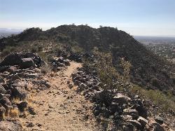
136 Hiking Trails near Holbert Trail to Dobbins Lookout
first prev 1 2 3 4 5 6 7 next lastShowing Hiking Trails within 50 miles Distance miles of Phoenix S Mountain Park, Phoenix, AZ 85042, USA City, Zip, or Address

Lower Salt River Nature Trail
Fort McDowell, Arizona
27.1 miles NEThe Lower Salt River Nature Trail is a scenic walk to take at the Tonto National Forest. This trail provides stunning views as you walk alongside the Salt River. This rustic trail is older and less...
Camp, Hike
Crismon Wash Trail
Mesa, Arizona
27.1 miles EThe Crismon Wash Trail is 1.8 mile trail that is accessible from the south at the Crismon road trailhead. It is also accessible from the Blevins train to the north. There are several...
Hike, Horseback, Mountain Bike 1.7 mi
Levee Trail
Mesa, Arizona
27.2 miles ELocated within the Usery Mountain Regional Park, the Levee trail is named so because it mostly follows the top of levee, running parallel to a large section of the channel trail and a Phoenix...
Hike, Horseback, Mountain Bike
Buckhorn Campground Nature Trail
Apache Junction, Arizona
27.3 miles ECamp and Hike near Apache Junction, Arizona
Camp, Hike 1.5 mi
Moon Rock Loop
Apache Junction, Arizona
27.4 miles ELocated within the larger Usery Mountain Regional Park, the Moon Rock loop is a fast and smooth trail that adds 1.3 miles to the more famous Blevins Trail. Although the Moon Rock loop is not known as...
Hike, Horseback, Mountain Bike
Sunrise Mountain Trail
Peoria, Arizona
28.0 miles NThe Sunrise Mountain Trail can be found within the suburban area of Peoria, Arizona; it is made of up 3 sequential loops; each loop harder than the last. The trail is easy to find, as...
Hike, Mountain Bike 4.8 mi
Lost Creek Petroglyph Trail
Buckeye, Arizona
28.1 miles WStarting at Verrado's trailhead, the trail heads a short ways to a petroglyph site. While a little rocky at times, the trail is easy. To deter vandals, a very necessary fence with barbed-wire has...
Hike, Mountain Bike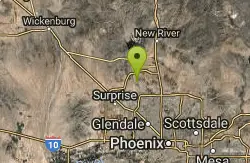
West Wing Mountain Advanced Trail
Peoria, Arizona
28.2 miles NHike near Peoria, Arizona
Hike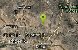
Tom's Thumb, Feldspar, and Marcus Landslide Loop
Scottsdale, Arizona
28.3 miles NEHike near Scottsdale, Arizona
Hike
Tom's Thumb Trail
Scottsdale, Arizona
28.3 miles NETom's Thumb Trail is a popular trail on the McDowell Sonoran Preserve due to its unique thumb-like granite rock formation. This is a 4.7 out-and-back, intermediate trail because of its 1,200...
Hike, Mountain Bike, Rock Climb 2.2 mi
Marcus Landslide Trail
Scottsdale, Arizona
28.3 miles NEThe Marcus Landslide Trail is named after ASU professor Melvin Marcus, a renouned geographer, after the discovery and recognition of the interesting geographical area in 2002. More than 500,000...
Hike, Horseback, Mountain Bike, Rock Climb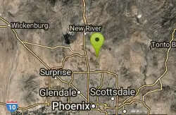
Apache Wash Trail
Phoenix, Arizona
28.5 miles NStart west on Ocitillo to Ridgeback north till you get to the crossing of Sidewinder then head west. Keep on Sidewinder toil you come to the crossing of Octillio and head east back to...
Hike
Pinnacle Peak Trail
Scottsdale, Arizona
28.6 miles NEPinnacle Peak is a 3.5 mile out-and-back, moderate hiking trail, that includes rock climbing routes (for experienced climbers), within the Sonoran Desert. This trail, and park, in...
Hike, Horseback, Rock Climb
Sidewinder, Apache Vista, Ocotillo Loop Trail
Phoenix, Arizona
28.7 miles NThis is an excellent loop that is very well maintained, well sign posted and if you include the vista summit trail, a moderate work out. Massive Car Park, good restrooms, and plenty of...
Hike, Horseback, Mountain Bike
Ocotillo/Ridgeback/Sidewinder Loop Trail
Phoenix, Arizona
28.8 miles NGreat moderate loop which includes a summit, great views and Classic Sonoran Desert scenery. Multiple access points and other connecting trails allows for the loop to be changed if...
Hike, Horseback, Mountain Bike
South, Bajada, Mule Deer Loop Trail
Waddell, Arizona
28.9 miles NWSouth - Bajada - Mule Deer Loop is a 4.1 mile loop trail located near Waddell, Arizona that offers the chance to see wildlife. The trail is rated as moderate and is accessible from...
Hike, Horseback, Mountain Bike
Bobcat Trail - Sonoran Preserve
Phoenix, Arizona
29.0 miles NBobcat Trail is a short, easy trail, often used for connecting to other bigger trails in the Sonoran Desert Preserve. This is a 2 mile out-and back trail. There isn't much of a parking...
Hike
Goat Camp Trail
Buckeye, Arizona
29.2 miles NWGoat Camp Trail is a well-liked mountain biking and hiking trail in White Tank Mountain Regional Park. This is a 16 mile out-and-back trail that is rated as advanced due to the length, as well as the...
Hike, Mountain Bike
Black Rock Loop Trail
Waddell, Arizona
29.5 miles NWBlack Rock Trail is a 1.3 mile loop trail located near Waddell, Arizona and is good for all skill levels. The trail is primarily used for hiking and is accessible year round. Black...
Hike
Wildlife Trail
Waddell, Arizona
29.6 miles NWA short trail which terminates at a small pond.
Hike, Horseback


