


136 Hiking Trails near Holbert Trail to Dobbins Lookout
first prev 1 2 3 4 5 6 7 next lastShowing Hiking Trails within 50 miles Distance miles of Phoenix S Mountain Park, Phoenix, AZ 85042, USA City, Zip, or Address

Mule Deer Trail (Maricopa Trail)
Waddell, Arizona
29.6 miles NWMule Deer trail is a 3.5 mile out-and-back trail that it part of the Maricopa Trail within White Tank Mountain Regional Park. This is a beginner to moderate friendly trail for both hikers and...
Hike, Horseback, Mountain Bike
Discovery Trail
Peoria, Arizona
30.4 miles NWDiscovery Trail is a path within Peoria, Arizona for residents of Vistancia. This concrete paved, 3.5 mile path meant for walking, running, and biking. Yoga, stargazing, and picnicking are...
Hike
Wagner-Granite-Bluff Trails
Scottsdale, Arizona
30.7 miles NEHike and Mountain Bike near Scottsdale, Arizona
Hike, Mountain Bike
Wagner Trail
Scottsdale, Arizona
30.7 miles NEWagner Trail is a 2.2 mile, beginner to intermediate loop trail located in the McDowell Sonoran Preserve. The trail is well-marked and easy to follow; this wide, but rugged...
Hike, Horseback, Mountain Bike
Tortoise and Hilltop Trails
Fort McDowell, Arizona
30.7 miles NEBe on the lookout for wildlife like jackrabbits and lizards on the initial stretch of trail (Tortoise Trail) and for mountain bikers as this trail joins the Pemberton Trail for a bit as...
Hike
Sidewinder-Ocotillo-West Loop
Phoenix, Arizona
30.9 miles NThis loop starts at Carefree Hwy and 7th Ave, be aware there is limited parking at the trailhead. The Ocotillo part of the trail is relatively flat and the Sidewinder part has some good...
Hike, Horseback, Mountain Bike
Tower Road - Sonoran Preserve
Phoenix, Arizona
30.9 miles NShort and steep (.6 mile each way) out and back asphalt road to the radio tower.
Hike
Pima and Dynamite Trail
Scottsdale, Arizona
31.1 miles NEPima and Dynamite is an area with a network of trails for hiking, but more popularly for mountain biking, in North Scottsdale, Arizona. The area feautures a variety of trails for...
Hike, Mountain Bike
Jane Rau Brown's Canyon Trail
Scottsdale, Arizona
31.2 miles NEThe Jane Rau Brown Canyon Trail was named after Jane Rau Brown, one of the pioneers of the McDowell Sonoran Conservancy, for her determination and passion in preserving the desert and the park....
Hike, Horseback, Mountain Bike
Brown Ranch Trail to Cone Mountain Trail
Scottsdale, Arizona
31.3 miles NEHike near Scottsdale, Arizona
Hike
Clay Mine Trail
Cave Creek, Arizona
33.0 miles NClay Mine Trail is a 1.6 mile out-and-back, beginner friendly trail in Cave Creek Regional Park. This is a trail that is very close to the Visitor Center. It's not too difficult but there...
Hike 5.8 mi
Go John Trail
Cave Creek, Arizona
33.5 miles NThe Go John Trail is a 5.8 mile loop trail outside of Cave Creek, Arizona, that is moderately trafficked, used by both hikers and mountain bikers. It is an excellent opportunity to view the desert...
Hike, Horseback, Mountain Bike

Siphon Draw Trailhead to Flatiron
Apache Junction, Arizona
34.8 miles EThe Siphon Draw Trail up to Flatiron is a beautiful trail within the Lost Dutchman State Park. It is a 5.5 mile, there and back trail near Apache Junction, Arizona. It is a more advanced hike with...
Hike
Brittlebush Trail
Phoenix, Arizona
35.7 miles SWBrittlebush trail is a flat, 12-mile round trip, out-and-back trail in the heart of the Maricopa Wilderness. It's best used from November - April, and should be avoided in the Summer months...
Hike, Mountain Bike 1.4 mi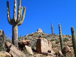
Ballantine Trail
Rio Verde, Arizona
43.7 miles NEthis trail looks a lot better once it moves away from the highway. A somewhat strenuous climb reveals a landscape of knuckle-and-joint, mica-imbedded boulders, deep gorges and a battalion of regal...
Hike 3.9 mi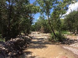
Cave Creek Swimming Hole
Cave Creek, Arizona
44.5 miles NHidden along Cave Creek Trail #4 is a swimming hole deep enough to refresh from the summer heat. It takes almost four miles of hiking in Arizona desert to reach the swimming hole, but the water is...
Hike, Swim


