


Ballantine Trail
Rio Verde, Arizona
| Address: | Ballantine Trailhead, 21075 Duthie-Martin Hwy, Rio Verde, AZ 85263, USA |
| GPS: |
33°45'51.8"N 111°29'36.2"W Maps | Directions |
| State: | Arizona |
| Trails/Routes: | 1.4 mi |
Hike
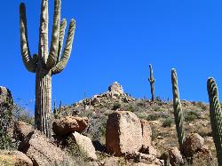
this trail looks a lot better once it moves away from the highway. A somewhat strenuous climb reveals a landscape of knuckle-and-joint, mica-imbedded boulders, deep gorges and a battalion of regal saguaro cactuses standing sentry. There’s even a mini-Stonehenge passage with naturally sculpted granite monoliths. Seasonal water doodling through the canyons adds a calming soundtrack to the impressive views.Courtesy of azcentral.com
This trail in its entirety is rarely done either as a shuttle or an out-and-back due to its overall length and the amount of driving required on FR143. This means that normally the upper (eastern) end of it (the best part) is the section that sees the least amount of traffic. This is one of several (but not too many) trails in AZ where a hiker will encounter both pine trees and saguaros. While it might be considered the easy way out, starting at the upper end of the trail and working your way west (and down, except for a short ascent at the start) has its advantages. The drive up and back down bumpy FR143 is left for later, but you'll still have to drive down later if you go the other direction. It's also an advantage to get an earlier start, which might be somewhat of an issue if you're attempting this one in late spring or early fall.Courtesy of hikearizona.com
The trailhead is located quite literally right off of the 87 Beeline Highway. There is a large sign indicating the Ballentine Trailhead with a right turn lane and is located about 20 miles northeast of Fountain Hills. The TH is never overly crowded and has enough room for about 20+ cars if people park correctly. From the trailhead there are two options; head to the north or head to the south. I chose to head north which runs parallel to the Beeline for about 1/2 a mile and then turns east and runs along Pine Creek. I would advise you to do the same as the northern trail is much easier with very little elevation gain. You'll need your endurance for the next 3 mile constant uphill challenge.Courtesy of arizonahikersguide.com
More Information
Be courteous, informed, and prepared. Read trailhead guidelines, stay on the trail, and don't feed the wildlife.
Read More- Plan Ahead and Prepare
- Travel & camp on durable surfaces
- Dispose of waste properly
- Leave what you find
- Minimize campfire impacts
- Respect wildlife
- Be considerate of other visitors
Directions
From Rio Verde, Arizona
- Head northeast on N Medelice Ln toward N Chinle Dr (0.2 mi)
- Turn right onto Poco Rio Dr (0.2 mi)
- Turn right onto Forest Rd (1.0 mi)
- Continue onto N Fort McDowell Rd (223 ft)
- Continue onto Mustang Way (5.5 mi)
- Mustang Way turns left and becomes N Fort McDowell Rd (0.1 mi)
- Continue onto N Ft McDowell Rd (1.1 mi)
- Continue onto N Fort McDowell Rd (3.0 mi)
- Turn left onto AZ-87 NDestination will be on the right(19.5 mi)


Trails
Distance ?
1.4 milesElevation Gain ?
408 feetReal Ascent ?
457 feetReal Descent ?
49 feetAvg Grade (3°)
5%Grade (-14° to 15°)
-25% to 28%Distance ?
1.4 milesElevation Gain ?
404 feetReal Ascent ?
588 feetReal Descent ?
184 feetAvg Grade (3°)
6%Grade (-16° to 15°)
-28% to 26%Elevation differences are scaled for emphasis. While the numbers are accurate, the cut-away shown here is not to scale.
Other Hiking Trails Nearby

Denton Trail #69
Tonto Basin, Arizona
10.1 miles EFrom FR 421, the trail climbs steadily up the east face of the mountain. Some sections are quite steep. The trail eventually tops out at 5,760 feet elevation and then descends to Big Pine Flat for...
Hike, Mountain Bike
Tortoise and Hilltop Trails
Fort McDowell, Arizona
14.4 miles WBe on the lookout for wildlife like jackrabbits and lizards on the initial stretch of trail (Tortoise Trail) and for mountain bikers as this trail joins the Pemberton Trail for a bit as...
Hike
Wagner Trail
Scottsdale, Arizona
14.5 miles WWagner Trail is a 2.2 mile, beginner to intermediate loop trail located in the McDowell Sonoran Preserve. The trail is well-marked and easy to follow; this wide, but rugged...
Hike, Horseback, Mountain Bike
Wagner-Granite-Bluff Trails
Scottsdale, Arizona
14.5 miles WHike and Mountain Bike near Scottsdale, Arizona
Hike, Mountain Bike
Fountain Hills Park
Fountain Hills, Arizona
16.7 miles SWFountain Park is a 1.3 mile loop trail located near Phoenix, Arizona ( in Fountain Hills) and is good for all skill levels. The trail is primarily used for hiking and is accessible...
Hike
Fountain Park Trail
Fountain Hills, Arizona
16.7 miles SWFountain views, Four Peaks view, desert vegetation, close to coffee! The trail is well groomed and well marked. It parallels some house as you begin to go up the first hill. About 15...
Hike, Mountain Bike 2.1 mi
Lower Salt River Nature Trail
Fort McDowell, Arizona
17.9 miles SWThe Lower Salt River Nature Trail is a scenic walk to take at the Tonto National Forest. This trail provides stunning views as you walk alongside the Salt River. This rustic trail is older and less...
Camp, Hike
Dixie Mine
Fountain Hills, Arizona
18.2 miles SWMcDowell Mountain Regional Park 16300 McDowell Mountain Park Dr. MMRP Arizona 85255 Ph: 480-471-0173 Fax: 602-372-8507 mcdowellpark@mail.maricopa.gov Mailing...
Hike
Thompsons Peak
Fountain Hills, Arizona
18.2 miles SWHike near Fountain Hills, Arizona
Hike
Sonoran Trail Fountain Hills
Fountain Hills, Arizona
18.2 miles SWHike near Fountain Hills, Arizona
Hike 2.2 mi
Marcus Landslide Trail
Scottsdale, Arizona
18.3 miles WThe Marcus Landslide Trail is named after ASU professor Melvin Marcus, a renouned geographer, after the discovery and recognition of the interesting geographical area in 2002. More than 500,000...
Hike, Horseback, Mountain Bike, Rock Climb
Tom's Thumb Trail
Scottsdale, Arizona
18.4 miles WTom's Thumb Trail is a popular trail on the McDowell Sonoran Preserve due to its unique thumb-like granite rock formation. This is a 4.7 out-and-back, intermediate trail because of its 1,200...
Hike, Mountain Bike, Rock Climb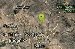
Tom's Thumb, Feldspar, and Marcus Landslide Loop
Scottsdale, Arizona
18.4 miles WHike near Scottsdale, Arizona
Hike
Sunrise Peak via Sunrise Trail
Scottsdale, Arizona
19.6 miles SWHike near Scottsdale, Arizona
Hike
Brown Ranch Trail to Cone Mountain Trail
Scottsdale, Arizona
20.0 miles WHike near Scottsdale, Arizona
Hike
Jane Rau Brown's Canyon Trail
Scottsdale, Arizona
20.0 miles WThe Jane Rau Brown Canyon Trail was named after Jane Rau Brown, one of the pioneers of the McDowell Sonoran Conservancy, for her determination and passion in preserving the desert and the park....
Hike, Horseback, Mountain Bike
Pima and Dynamite Trail
Scottsdale, Arizona
20.1 miles WPima and Dynamite is an area with a network of trails for hiking, but more popularly for mountain biking, in North Scottsdale, Arizona. The area feautures a variety of trails for...
Hike, Mountain Bike 1.5 mi
The Saddle
Mesa, Arizona
20.9 miles SWSaddle trail is an intermediate mountain biking trail that connects to the greater Hawes trail network. The trail is 1.5-2mi long and it offers beautiful views of the neighboring Salt River and Red...
Hike, Mountain Bike 7.5 mi
Hawe's Loop
Mesa, Arizona
21.0 miles SWMost of the trails in the Phoenix metropolitan area were originally built by mountain bikers, and the Hawe's loop trail system and trail are no exeptions. This trail features fantastic...
Hike, Mountain Bike
Siphon Draw Trailhead to Flatiron
Apache Junction, Arizona
21.1 miles SThe Siphon Draw Trail up to Flatiron is a beautiful trail within the Lost Dutchman State Park. It is a 5.5 mile, there and back trail near Apache Junction, Arizona. It is a more advanced hike with...
HikeNearby Campsites
Lower Salt River Nature Trail
Fort McDowell, Arizona
17.9 miles SWThe Lower Salt River Nature Trail is a scenic walk to take at the Tonto National Forest. This trail provides stunning views as you walk alongside the Salt River. This rustic trail is older and less...
Camp, Hike
Buckhorn Campground Nature Trail
Apache Junction, Arizona
21.4 miles SCamp and Hike near Apache Junction, Arizona
Camp, Hike
Hell's Gate
Payson, Arizona
38.8 miles NEThis Wilderness was established in 1984, and contains approximately 37,440 rough acres with a major canyon and perennial stream extending its entire length. Deep pools of water may be separated by...
Backpack, Camp, Hike, Swim
Verde Hot Springs
Camp Verde, Arizona
42.0 miles NVerde Hot Springs are a few natural hot spring pools located along the Verde River, near Sedona, Arizona. Once a resort, now all that remains are the foundations and the hot pools...
Camp, Hike, Hot Springs
Haigler Canyon Campground
Payson, Arizona
43.7 miles NEThis campground was constructed in 2007 and offers 2 day-use sites and 2 campground areas with 14 overnight sites. This campground boasts a diversity of trees. Fishing for rainbow trout is a popular...
Camp, Hike, Swim
Upper Tonto Creek Campground
Payson, Arizona
45.6 miles NEUpper Tonto Creek Campground is a beautiful place to camp at the intersection of Tonto and Horton Creeks. In addition to camping, this is a popular destination to both fish and hike. The campground...
Camp, Hike 1.1-3.5 mi
Horton Springs
Payson, Arizona
45.8 miles NEHorton Springs is a spring on the Mogollon Rim that leads into Horton Creek. There are campsites near the springs, and several hiking trails in the area that lead to the spring itself. Between the...
Backpack, Camp, Hike 1.1 mi
Christopher Creek Campground
Payson, Arizona
45.9 miles NEChristopher Creek is a popular campground situated just east of Payson, nestled between the Christopher Creek river, and the town of the same name. This site is used for both overnight and day-use...
Camp, Canyoneer, Cross-country Ski, Hike, Swim
Aspen Campground
Payson, Arizona
49.9 miles NEAspen Campground is a large campground near Payson, Arizona. Between the proximity to Woods Canyon Lake and the seclusion of the encompassing Apache-Sitgreaves National Forest, this is a...
Camp


