


4 Hiking Trails near Lake Selmac
first prev 1 next lastShowing Hiking Trails within 50 miles Distance miles of Lake Selmac near Selma, Oregon City, Zip, or Address
Add Location
Illinois Hidden Access
Selma, Oregon
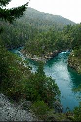
6.3 miles WA 30-foot waterfall and spectacular swimming hole deep in the Rogue River canyon — accessed via a 9-mile round-trip hike on a hot, dry, difficult trail; bring plenty of water and be prepared for a workout.
Camp, Hike, Mountain Bike, Swim
Lower Table Rock
Medford, Oregon
39.7 miles EA moderate 2.7-mile hike gaining 800 feet to the top of Lower Table Rock — historic treaty land now managed by BLM and the Nature Conservancy, with guided tours available.
Hike
Forks River Access
Hiouchi
40.7 miles SWFree Forest Service day-use access at the confluence of the South Fork and the Smith River near Hiouchi, with short paths to sand and pebble beaches, cliff pools and the Second Bridge swim spot.
Canoe, Hike, Kayak, Swim
Upper Table Rock
Eagle Point, Oregon
43.1 miles EUpper Table Rock and Lower Table Rock are two prominent volcanic plateaus located just north of the Rogue River in Jackson County, Oregon.
Hike


