


Natural Bridges State Park / Monarch Butterfly Trail
Santa Cruz, California

| Address: | Natural Bridges State Beach, 2531 W Cliff Dr, Santa Cruz, CA 95060, USA |
| GPS: |
36°57'11.0"N 122°3'21.0"W Maps | Directions |
| State: | California |
| Trails/Routes: | 0.1-0.9 mi |
Restrooms Picnic Tables Trails Ponds Bicycles State Park
Hike
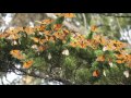
This trail is perfectly tucked away from the business of Santa Cruz. Monarch butterflies, during the Winter, fly here to stay warm. As you walk through the Monarch Grove, you will see trees covered with butterflies. Their wings fluttering look like tree leaves blowing in the wind, until you take a closer look. It is a peaceful place to be as you learn about Monarch butterflies and watch them fly around.
Monarch butterfly migration begins at different times but they start arriving in the grove around mid-October. This is the perfect time of year to take a nice stroll on the boardwalk and watch the butterflies. The park is filled with eucalyptus trees which give the butterflies the perfect protection for them in the winter months. Since this is a preserve, it is asked not to grab or hold butterflies and to stay quiet to help continue making them feel safe. The end of the Monarch season is around mid-February. It is the perfect, family friendly location.
There is one main trail, but you can customize the length of your walk/hike depending on what you would like to do.
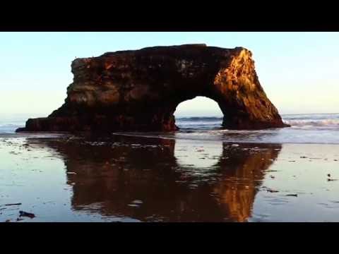
The trail leads to a beautiful sandy beach. You will see a huge, beautiful rock arch to your left of the beach. The water is refreshingly cool. Watching the sunset over the water, pulls out the orange colors of the arch rock making the scene bright and peaceful.
This is the perfect location to see shore birds, migrating whales, and playing otters offshore. As you continue to walk around the beach, you will come across tide pools where you can get a glimpse of sea life. The low tide allows visitors to see star fish and other sea animals. It is a great location for families to explore and enjoy their time together.
Important Information: There is a $10 vehicle day-use fee. The water is shallow enough for children to play safely, but it is necessary for parents to supervise their children because there aren't lifeguards on duty. Bikes are permitted on the paved roads around the park and beach. Dogs are also permitted on paved roads and in the park but not on the beach.
More Information
Be courteous, informed, and prepared. Read trailhead guidelines, stay on the trail, and don't feed the wildlife.
Read More- Plan Ahead and Prepare
- Travel & camp on durable surfaces
- Dispose of waste properly
- Leave what you find
- Minimize campfire impacts
- Respect wildlife
- Be considerate of other visitors
Directions
From Santa Cruz, California
- Head north on Chestnut St toward Rincon St (118 ft)
- Slight left onto Chestnut St Ext (0.2 mi)
- Turn left onto CA-1 N/Mission StContinue to follow CA-1 NPass by Burger King (on the left in 1.2 mi)(1.5 mi)
- Turn left onto Swift StPass by 7-Eleven (on the left)(0.3 mi)
- Turn right onto Delaware Ave (0.4 mi)
- Turn left onto Swanton Blvd (0.4 mi)
- Turn right onto W Cliff Dr (0.4 mi)
- Turn right (151 ft)
Take Swift St. south from Highway 1, or follow West Cliff Dr. west along the in-town bluffs until it ends at Natural Bridges.
jamiegarrard
5/31/18 11:14 am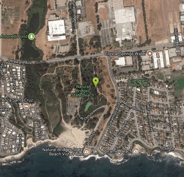

Trails
Distance ?
0.5 milesElevation Gain ?
-28 feetReal Ascent ?
43 feetReal Descent ?
71 feetAvg Grade (-1°)
-1%Grade (-17° to 32°)
-30% to 62%Distance ?
0.9 milesElevation Gain ?
-5 feetReal Ascent ?
109 feetReal Descent ?
114 feetAvg Grade (0°)
0%Grade (-15° to 19°)
-27% to 34%Distance ?
409 feetElevation Gain ?
-32 feetReal Ascent ?
0 feetReal Descent ?
32 feetAvg Grade (-4°)
-8%Grade (-7° to -1°)
-13% to -2%Elevation differences are scaled for emphasis. While the numbers are accurate, the cut-away shown here is not to scale.
Other Hiking Trails Nearby

Garden of Eden
Felton, California
4.9 miles NA great swimming hole in the Santa Cruz moutains of California, the Garden of Eden lives up to its name. This swimming hole is popular among all ages and offers beaches perfect for sunbathing and...
Hike, Swim
Pescadero Creek Trail Area
Loma Mar, California
25.6 miles NWPerfect for all redwood lovers, the Pescadero Creek Park area is an incredible shady trail for a hike on a hot summer day. This is a great place to escape from city sounds and enjoy...
Hike, Horseback, Mountain Bike, Swim
Henry Coe State Park Campground
Morgan Hill, California
32.4 miles NEHenry W. Coe State Park is primarily a wilderness park. Spring is the most popular time of year to visit with fabulous displays of wildflowers. Camping is permitted all year. There are numerous...
Camp, Hike, Horseback, Mountain Bike
China Hole
Morgan Hill, California
34.4 miles NEThis moderately strenuous hike takes you to the site of an old mineral springs resort and to the park's most popular swimming hole, a mile farther along. Madrone Soda Springs Resort was a small...
Camp, Hike, Swim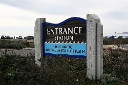
Half Moon Bay State Beach
Half Moon Bay, California
41.5 miles NWHalf Moon Bay State Park's Coastside Trail runs parallel to the Pacific Coast along what used to be the Ocean Shore Railroad. The railroad itself was in operation for just 14 years before it was...
Camp, Hike, Horseback, SwimNearby Campsites
Henry Coe State Park Campground
Morgan Hill, California
32.4 miles NEHenry W. Coe State Park is primarily a wilderness park. Spring is the most popular time of year to visit with fabulous displays of wildflowers. Camping is permitted all year. There are numerous...
Camp, Hike, Horseback, Mountain Bike
China Hole
Morgan Hill, California
34.4 miles NEThis moderately strenuous hike takes you to the site of an old mineral springs resort and to the park's most popular swimming hole, a mile farther along. Madrone Soda Springs Resort was a small...
Camp, Hike, Swim
Half Moon Bay State Beach
Half Moon Bay, California
41.5 miles NWHalf Moon Bay State Park's Coastside Trail runs parallel to the Pacific Coast along what used to be the Ocean Shore Railroad. The railroad itself was in operation for just 14 years before it was...
Camp, Hike, Horseback, Swim


