


235 Things to do near Double Butte Loop Trail
first prev 1 2 3 4 5 6 7 8 9 10 next lastShowing results within 50 miles Distance miles of Eliot Ramada Loop, Phoenix, AZ 85008, USA City, Zip, or Address

Papago Park Area
Phoenix, Arizona
0.0 miles NEPapago Park offers a large area for mountain bikers, consisting of 5 beginner-intermediate loops and a dirt jump area for experts. Much of the area has a mix of loose dirt and rolling hills, so the...
Mountain Bike
Papago to Tempe Town Lake
Phoenix, Arizona
0.9 miles NWThere are many paths that interconnect within Papago park and the nearby Tempe Town Lake. Any of these in combination provide a good walk or bike riding experience with a variety of views. Papago...
Hike
Moeur Park
Phoenix ( Tempe), Arizona
1.0 miles SEThis course will scuff your discs. Next to a dry wash - water runs sometimes and increases difficulty. Fun, hot, dusty and challenging. Public (No Fee)
Disc Golf
Crosscut Canal Trail
Tempe, Arizona
1.1 miles SECrosscut Canal Trail is a concrete, sidewalk multi-use trail for walking, biking, wheelchairs, scooters, and skateboards. This two mile long path follows a canal and links Tempe Town Lake to...
Hike 4.9 mi
Tempe Town Lake Trail
Tempe, Arizona
1.4 miles SEOn the lake's south side, the trail connects Arizona State University's main Tempe campus with Tempe Beach Park, as well as the Tempe Marketplace retail mecca. A newer extension on the...
Hike 2.0 mi
Loma and Canal Trails
Tempe, Arizona
1.4 miles SETrails open to mountain biking and hiking that wind through the Papago Park in Tempe, Arizona. The Loma Trail winds around lots of uphill and downhill paths, and leads to a park with a small lake and...
Hike, Mountain Bike
Hayden Butte And Tempe Town Lake Trail
Tempe, Arizona
2.1 miles SEHike near Tempe, Arizona
Hike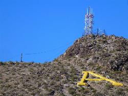
'A' Mountain at Hayden Butte
Tempe, Arizona
2.3 miles SE'A' Mountain aka Hayden Butte, is a popular hike in downtown in Tempe, Arizona. This hike located partially on Arizona State University's campus, is a short, easy walk, though it's...
Hike
Vista del Camino Park
Scottsdale, Arizona
2.4 miles EThe Shelly Sharpe Memorial Disc Golf Course at Vista del Camino was installed in 1984 and redesigned in 1997 by PDGA Hall of Fame member Dan Ginnelly. It is a pretty level and open course - water...
Disc Golf
The Wedge Skate park
Scottsdale, Arizona
2.4 miles EThe Wedge Skatepark is a part of the Scottsdale Park System. The Wedge is located at Eldorado Park - 2311 N. Miller Rd. (roughly Miller & McDowell) The skatepark is open from daylight till...
Skateboard
Papago Park Area Mountain Bike Trail
Scottsdale, Arizona
3.6 miles EMountain Bike near Scottsdale, Arizona
Mountain Bike 1.0-1.2 mi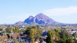
Camelback Mountain
Phoenix, Arizona
4.7 miles NHiking After Camelback became a park in 1968, TripAdvisor advertised the hikes as one of the top 10 things to do when in Phoenix. Located right in the middle of Phoenix, Scottsdale and...
Hike, Rock Climb
Los Olivos
Phoenix, Arizona
4.8 miles NWFlat, grassy neighborhood park (used to be an olive orchard). Lots of trees. Busy on weekends. Easy to navigate. Public (No Fee)
Disc Golf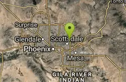
Vista Del Camino Park - 2009 Memorial Layout
Scottsdale, Arizona
5.8 miles NEAlso known as Shelly Sharpe Memorial DGC. Plays long. Basically level with some hills. Lots of trees. Three small lakes come into play on 7 holes. Hotels nearby. Public (No Fee)
Disc Golf 1.9 mi
Javelina Trail
Phoenix, Arizona
5.8 miles SComing down Javelina is fast and fun no doubt. It sure beats the crowded Pima Canyon trail back to the Pima lot if you parked there. Javelina is just one more sweet trail on South Mountain. Not a...
Hike, Horseback, Mountain Bike 1.8 mi
Javelina-Beverly Canyon Loop Trail
Phoenix, Arizona
5.9 miles SJavelina Canyon Trail does have some beautiful hills and valleys to wander through and it feels down right remote at times. I’ve found Javelina to have less traffic that Beverly as...
Hike, Horseback, Mountain Bike
Arizona Canal Trail
Phoenix, Arizona
6.1 miles NWMulti-purpose canal trails set apart from normal city traffic and noise. The Arizona Canal is one of the many canals used to supply the valley with its water needs (irrigation). These canals were...
Hike, Horseback 1.7 mi
Quartz Ridge Trail
Phoenix, Arizona
6.3 miles NWThis is a very popular trail on weekend mornings. Casual hikers can get great views of Phoenix with moderate effort. Good place to bring out of town visitors The Quartz Ridge Trail is a short,...
Hike, Mountain Bike 1.5 mi
Desert Classic
Phoenix, Arizona
6.6 miles SThe Desert Classic trail is just that, a classic at the South Mountain Park area. Because it is such a classic, the trail is well marked and well worn by high traffic flow of riders and hikers....
Hike, Mountain Bike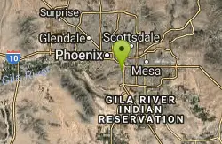
Desert Classic - Goat Trail
Phoenix, Arizona
6.6 miles SHike and Mountain Bike near Phoenix, Arizona
Hike, Mountain Bike


