


233 Things to do near Piestewa Peak Summit Trail #300
first prev 3 4 5 6 7 8 9 10 11 12 next lastShowing results within 50 miles Distance miles of Piestewa Peak Summit Trail, Phoenix, AZ 85016, USA City, Zip, or Address
McDowell Mountain Park
Fort McDowell, Arizona
20.4 miles NEThis trail is great. It is not as rocky as other Phoenix area trails( ie: Trail 100, National, Estrella Mtn Park). Twisty singletrack on rolling contour. The surface consists of small...
Mountain Bike
Pemberton Loop
Fort McDowell, Arizona
20.4 miles NEThere are many places to start this loop from really as it crosses other trails and the main road twice. The 15 mile loop can be cut in half or about more by either the Tonto Tank tr or...
Mountain Bike
Riparian Preserve at Water Ranch Trail
Gilbert, Arizona
20.6 miles SEThe Riparian Preserve is an urban park with a series of loop trails surrounding seven ponds stocked with fish and birds. It is located at 2757 E. Guadalupe Road, Gilbert AZ. Several...
Canoe, Hike 8.3 mi
Estrella Mountains Competitive Track
Tolleson, Arizona
20.6 miles SWThe third competitive track in the Maricopa County Regional Park system, located in Estrella Mountain Regional Park, was completed in February 2000. The track consists of two loops totaling 13 miles....
Hike, Horseback, Mountain Bike 21.4 mi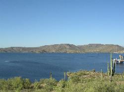
Spur Cross to Lake Pleasant
Cave Creek, Arizona
20.7 miles NStart at the Flat Tire Bike Shop and head north on Spur Cross Road. You will arrive at the Spur Cross Conservation Ranch in 3.2mi. From there enter the Maricopa Trail system and follow the signs...
Mountain Bike
Cave Creek Park
Cave Creek, Arizona
20.7 miles NMultiple singletrack loops, just explore and find what works best for you. Watch out for hikers and horses.
Mountain Bike 2.1 mi
Lower Salt River Nature Trail
Fort McDowell, Arizona
20.9 miles EThe Lower Salt River Nature Trail is a scenic walk to take at the Tonto National Forest. This trail provides stunning views as you walk alongside the Salt River. This rustic trail is older and less...
Camp, Hike
Granite Mountain Loop
Scottsdale, Arizona
20.9 miles NEThis is a multi-use trail with hikers and equestrians, but for the most part it is not well-traveled. Much of the trail is single-track and the west side of Granite Mountain has a...
Mountain Bike
Red Mountain - North
Mesa, Arizona
21.7 miles EThe North course is the more challenging of the two courses on site. It begins in the desert and works it way back into the park. Bring lots of water and be prepared for desert plant life, as well as...
Disc Golf
Red Mountain - South
Mesa, Arizona
21.7 miles EEntirely in desert, this is the easier of the two courses on site. Bring water and be prepared for the desert terrain. There are plenty of big trees to challenge as well. Note: rattlesnakes have been...
Disc Golf
Discovery Trail
Peoria, Arizona
22.0 miles NWDiscovery Trail is a path within Peoria, Arizona for residents of Vistancia. This concrete paved, 3.5 mile path meant for walking, running, and biking. Yoga, stargazing, and picnicking are...
Hike
Whiskey Bottle Trail
Scottsdale, Arizona
22.3 miles NEThe trail starts off with sandy single-track then starts a gradual ascent up the side of Fraesfield mountain. The trail then sharply increases (total of 800' elevation gain) and becomes...
Mountain Bike

Chandler Skatepark
Chandler, Arizona
22.8 miles SEChandler, an outdoor 33,000-square-foot park, has been reported to be the best skatepark in Arizona. Designed by SITE Systems Design Group, it features ledges, two bowls, banks, quarterpipes,...
Skateboard
Baseline Trail
Goodyear, Arizona
22.8 miles SWThe Baseline trail is a 2.6 mile loop at Estrella Mountain Regional Park. This listing is based on access from a spur trail (33.378981, -112.371072) off of the Gila trail. Access is...
Hike 13.8 mi
Butterfield to Gadsen Loop Trail
Goodyear, Arizona
23.1 miles SWAs with other trails in Estrella, the trail is wide and the surface tends to be rather benign, varying from mostly smooth, to occasionally strewn with small rocks, sandy in the washes. Butterfield...
Hike, Horseback, Mountain Bike 2.9 mi
Coldwater Trail
Goodyear, Arizona
23.1 miles SWThe Cold Water Trail #27 is a seldom visited, remote backcountry destination along the backdrop of the rugged Verde Rim with healthy mixed vegetation and unique geology. The trail was originally used...
Hike, Horseback, Mountain Bike
Paseo Vista Recreation Area
Chandler, Arizona
23.2 miles SEMulti-use park on a former land fill site. 11 holes have dual tees and 1 hole has 2 baskets. Mostly wide open with some OB. Features 2 concrete culvert mandos through pipe. Multiple berms and a...
Disc Golf
Estrella Mountain Park
Goodyear, Arizona
23.3 miles SWNice mix of singletrack and doubletrack. One way loops, long loop and tech loop. A few mild climbs and some mild rock gardens, just let it ride. There is a lot of loose rocks on the...
Mountain Bike 3.6 mi
Toothaker Trail
Goodyear, Arizona
23.3 miles SWToothaker is an easy roller coaster of a trail. It crosses numerous washes ranging from small to large and can be a tad loose and/or rocky in some sections. The end reward is a nice view of Rainbow...
Hike, Horseback, Mountain Bike
Dysart Trail
Goodyear, Arizona
23.3 miles SW$6 entry fee per car.
Hike, Horseback, Mountain Bike


