


103 Things to do near Willard Springs
first prev 1 2 3 4 5 6 next lastShowing results within 50 miles Distance miles of Forest Service Rd 253, Sedona, AZ 86336, USA City, Zip, or Address

Cave Springs
Sedona, Arizona
2.2 miles WCave Springs Campground is a scenic campground that sits in Oak Creek Canyon. Cave Springs is nestled perfectly in the town of Sedona, giving the campground the notorious Sedona red views. Uniquely,...
Camp, Hike, Swim 1.0 mi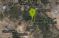
Harding Springs Trail
Sedona, Arizona
2.2 miles NWHarding Springs Trail is a beautiful hiking trail in Sedona, Arizona. This trail was originally one of several that provided a way for cattlemen to drive their stock in and out of Oak Creek...
Hike 0.3 mi
Slide Rock
Sedona, Arizona
4.1 miles SWSlide Rock is one of the most popular locations in the Sedona area. Slide Rock is natures most thrilling water slides. Slide Rock is a gargantuan 80 feet long, and 2-4 feet wide. This slippery slope...
Hike, Swim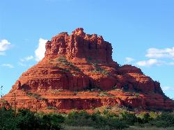
Schnebly Hill Vista Overlook
Sedona, Arizona
6.6 miles SThe Schnebly Hill Formation is a beautiful red rock gem in Sedona, Arizona. This rock formation is considerably big, which is why it is divided into four different sections that are called...
Hike 3.4 mi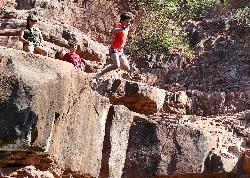
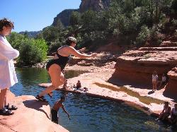
Grasshopper Point
Sedona, Arizona
7.0 miles SGrasshopper Point is a beautiful swimming hole located in Sedona, Arizona. Grasshopper Point is the perfect place to cool off in the summer after a nice hike, or a hot summer day. This swimming...
Dive, Hike, Swim
Schnebly Hill Trail
Sedona, Arizona
7.1 miles SThe Schnebly Hill Trail dead ends at the wilderness area, but can be accessed from a road at the top. Essentially this trail functions as the upper half of the Munds Wagon trail,...
Mountain Bike
Wilson Mountain Trail
Sedona, Arizona
7.2 miles SHike near Sedona, Arizona
Hike
Midgley Bridge Trail
Sedona, Arizona
7.2 miles SHike near Sedona, Arizona
Hike 8.5 mi
Munds Wagon Trail
Sedona, Arizona
7.6 miles SMunds Wagon Trail is different from many of the other more “classic†rides around Sedona. If you come from somewhere else and are missing the feel of loose rocks...
Hike, Mountain Bike
Brins Mesa Trail
Sedona, Arizona
7.6 miles SWBrins Mesa Trail is located in the Coconino National Forest just at the edge of the town of Sedona. This trail will provide picturesque views of the gorgeous, geological landscape. Brins...
Hike
Cow Pies
Sedona, Arizona
7.8 miles SThe Cow Pies trail functions as a climb up to the Hangover trail from the Munds Wagon Trail. Much of this trail is sweet, sweet slickrock, with awesome views.
Mountain Bike
Jim Thompson
Sedona, Arizona
7.9 miles SWThis trail is best ridden west to east unless you like a serious climb. Either way, you'll be treated to some great scenery. Much of the trail is wide and covered with loose rocks....
Mountain Bike
Devil's Bridge
Sedona, Arizona
8.4 miles SWWe loved the red rock views on this hike! It's a 3.6 mile round-trip trail, on rocky/sandy ground, and is fairly easy, until the last mile, which is steep. Dozens of jeeps and ATVs passed us -...
Hike 6.0 mi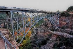
Huckaby Trail
Sedona, Arizona
8.6 miles SOn the hunt for adventure? Established in 1998, Huckaby Trail is just the adventuresome route for both avid hikers and mountain bikers. It offers up forestry of Arizona Sycamores and picturesque...
Canoe, Hike, Mountain Bike
Hangover
Sedona, Arizona
8.6 miles SUpdated description by Greg Heil:Hangover is an incredibly technical trail, with high consequences if you mess up. With serious exposure, technical features, steep rock rolls, tight...
Mountain Bike
Courthouse Butte Loop
Sedona, Arizona
8.9 miles SCourthouse Butte Loop: To get to this wonderful trail, take the wide Bell Rock Pathway from the kiosk toward Bell Rock. It climbs gently and at ½ mile there is a signed...
Mountain Bike
Soldier Wash Trails
Sedona, Arizona
9.3 miles SWWhat locals once called the "Secret Trails" isn't so secret anymore. The USFS has adopted many of them into what is now called "Soldier Wash Trails." You may not see them yet on the...
Mountain Bike
North Urban Trail System - East
Sedona, Arizona
9.3 miles SWThe North Urban Trail System is an interconnected series of trails north of Sedona along the red rock front country. These trails extend from the Jim Thompson Trailhead on the east end...
Mountain Bike
Mescal Trail
Sedona, Arizona
9.4 miles SWMany of the newer trails and best riding in the Sedona area are in the Boynton Pass area. The route described with the accompanying TOPO map includes all or part of Chuckwagon, Mescal,...
Mountain Bike
Dawa Loop
Sedona, Arizona
9.8 miles SWSometimes you are traveling with kids or neophyte mountain bikers and are wondering where to take them. The following route describes a fun and fairly easy practice trail. Can't...
Mountain Bike


