


Grasshopper Point
Sedona, Arizona
| Address: | N State Rte 89A, Sedona, AZ 86336, USA |
| GPS: |
34°53'16.3"N 111°43'56.7"W Maps | Directions |
| State: | Arizona |
| Trails/Routes: | 3.4 mi |
Dive, Hike, and Swim
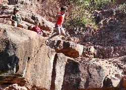
Grasshopper Point is a beautiful swimming hole located in Sedona, Arizona. Grasshopper Point is the perfect place to cool off in the summer after a nice hike, or a hot summer day. This swimming hole is nestled perfectly in Oak Creek Canyon. The swimming hole is managed by National Forest Service. Grasshopper Point offers alluring views of crimson red rock and teal colored water. For those who are jumpers, there are many cliffs that can offer amazing cliff jumping experiences. Grasshopper Point is the perfect place to cool off in the summer after a nice hike, or a hot summer day.
This swimming hole can be reached from Allen's bend, and it is connected to the Huckaby Trail. In an ideal day, you could hike these trails and be led straight to the swimming hole for a fun day of water activity. Grasshopper Point is open year round from 9am to 6pm Mondays through Thursdays, and from 8am to 6pm on Fridays through Sundays. Nearby the swimming hole there are amenities like picnic tables and restrooms. Drinking water is not available at this location. Be sure to bring a sufficient water supply. During the summer this location becomes quite popular. If the swimming hole gets too full on a certain day, management will put up a sign that says "full" by the entry.
More Information
This Arizona Swimming Hole is The Perfect End to A Scenic Hike
There’s no denying that Arizona gets hot and steamy in the summer months, and many locals and tourists turn to public pools and city splash pads to cool off. But there are also some wonderful ways to take a dip and cool off in nature if you’re feeling adventurous and love the outdoors.
https://www.holidays.com/grasshopper-point-sedona-arizona/Be courteous, informed, and prepared. Read trailhead guidelines, stay on the trail, and don't feed the wildlife.
Read More- Plan Ahead and Prepare
- Travel & camp on durable surfaces
- Dispose of waste properly
- Leave what you find
- Minimize campfire impacts
- Respect wildlife
- Be considerate of other visitors
Directions
From Sedona, Arizona
- Head east toward N State Rte 89A (118 ft)
- Exit the traffic circle onto AZ-89A N/
N State Rte 89A (2.2 mi) - Turn right (125 ft)
- Turn rightDestination will be on the left(0.2 mi)
From the Huckaby Trail
Head north on Huckaby Trail toward Midgely Bridge Trail
1.0 mi
Turn right onto Midgely Bridge Trail
0.3 mi
Turn right
*Destination will be on your left*
0.1 mi


Other Swimming Holes, Hiking Trails, and Diving Platforms Nearby

Wilson Mountain Trail
Sedona, Arizona
0.5 miles WHike near Sedona, Arizona
Hike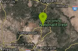
Midgley Bridge Trail
Sedona, Arizona
0.5 miles WHike near Sedona, Arizona
Hike 4.2 mi
Munds Wagon Trail
Sedona, Arizona
1.7 miles SEA gnarly, loose-rock mountain bike climb near Sedona with 1,700 feet of elevation gain over six miles, delivering increasingly jaw-dropping views the higher you ride.
Hike, Mountain Bike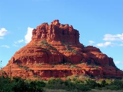
Schnebly Hill Vista Overlook
Sedona, Arizona
1.7 miles EA sweeping red rock formation divided into four geological members — from reptile-fossil-bearing sandstone to limestone and dolomite — telling 500-foot stories of Sedona's ancient past.
Hike 3.0 mi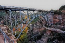
Huckaby Trail
Sedona, Arizona
1.7 miles SWA 3-mile Sedona trail through Arizona Sycamores and striking Red Rock formations — crossing Oak Creek at the bottom where you can take a dip, with a boulder passage and optional mountain bike cruise on the other side.
Canoe, Hike, Mountain Bike
Chavez Crossing
Sedona, Arizona
4.0 miles SWA campground on Oak Creek in Sedona's red-rock canyon, perfectly placed for cool water play, sunsets over Munds Mountain, and access to nearby swimming holes.
Camp, Hike, Swim 0.3 mi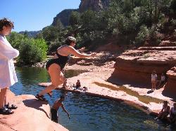
Slide Rock
Sedona, Arizona
4.0 miles NAn 80-foot-long natural waterslide lined with algae on Oak Creek — named one of America's Top Ten Swimming Holes, inside a 43-acre historic apple farm homestead in a stunning red rock canyon.
Hike, Swim
Devil's Bridge
Sedona, Arizona
4.6 miles WA 3.6-mile round-trip trail in Sedona to the breathtaking Devil's Bridge rock arch — rocky and sandy with a steep final mile, stunning red rock views, and very popular on weekends.
Hike
Brins Mesa Trail
Sedona, Arizona
4.7 miles NWAn open-mesa hike through red rock towers and formations in Coconino National Forest just outside Sedona — unobstructed desert views that intensify with summer heat, so bring plenty of water.
Hike
Red Rock State Park
Sedona, Arizona
6.1 miles SWRed Rock's crimson sandstone layers tell 275 million years of geologic history — from ancient beachfronts to sand dunes to shallow seas — and inspired an art migration that fills the area with museums and galleries today.
Hike, Swim 0.1-0.7 mi
Cave Springs
Sedona, Arizona
7.5 miles NAn 84-site campground on Oak Creek in Sedona's canyon, with picnic tables and natural tree shade, close to Slide Rock, swimming holes, and the Coconino National Forest.
Camp, Hike, Swim 1.0 mi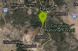
Harding Springs Trail
Sedona, Arizona
7.8 miles NA mostly shaded, gradual climb to Oak Creek Canyon's rim along a historic cattle drive route — with rest stops along the way and the option to continue north or south at the top.
Hike 0.2 mi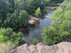
Mormons Crossing
Cornville, Arizona
13.5 miles SWShaded swimming holes, gentle rapids, and a rope swing along Oak Creek — an easy spot to cool off in Cornville.
Swim 7.1 mi
The Crack at Wet Beaver Creek
Rimrock, Arizona
14.8 miles SCrystal-clear water and cliffs high enough to jump from, about 3.5 miles down Bell Trail along Wet Beaver Creek — a rewarding desert hike to a stunning red-rock swimming hole.
Dive, Hike, Horseback, Swim
Beaver Creek Campground
Camp Verde, Arizona
15.1 miles SBeaver Creek is a refreshing creekside oasis in the high desert of central Arizona, where the cool, clear waters of Wet Beaver Creek wind beneath big cottonwoods and sycamores in the Coconino...
Camp, Canoe, Kayak, Swim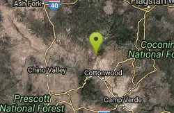
Sycamore Canyon
Sedona, Arizona
19.1 miles WA pleasant 3.5-mile round-trip canyon hike along a perennial stream to several swimming holes — bathing suits may be optional at the more distant pools in Sycamore Canyon.
SwimBullpen Day Use Area
Camp Verde, Arizona
24.1 miles SA big red jumping rock on West Clear Creek, shaded picnic areas, and trails down a stunning canyon below the Mogollon Rim — a full afternoon of swimming and hiking.
Backpack, Dive, Hike, Swim 8.4 mi
West Clear Creek Trail No. 17
Camp Verde, Arizona
24.1 miles SWest Clear Creek Trail winds down a shaded canyon to cool creek swimming, fishing, and dispersed camping — bring wading shoes, because wet feet are guaranteed.
Backpack, Hike, Swim 3.0 miBlodgett Basin Trail No. 31
Camp Verde, Arizona
24.1 miles SA 3-mile riparian canyon trail through West Clear Creek Wilderness with 1,700 feet of elevation change, fishing, camping, and wading in a desert oasis — expect to get your feet wet.
Backpack, Hike, Swim 0.4 mi
Clear Creek Campground
Camp Verde, Arizona
25.8 miles SA grassy creekside campground shaded by tall cottonwoods on West Clear Creek — ideal for hiking, swimming, fishing for smallmouth bass and sunfish, and wildlife watching in a desert canyon oasis.
Camp, Hike, SwimNearby Campsites
Chavez Crossing
Sedona, Arizona
4.0 miles SWA campground on Oak Creek in Sedona's red-rock canyon, perfectly placed for cool water play, sunsets over Munds Mountain, and access to nearby swimming holes.
Camp, Hike, Swim 0.1-0.7 mi
Cave Springs
Sedona, Arizona
7.5 miles NAn 84-site campground on Oak Creek in Sedona's canyon, with picnic tables and natural tree shade, close to Slide Rock, swimming holes, and the Coconino National Forest.
Camp, Hike, Swim
Beaver Creek Dispersed Camping
14.8 miles S
Free dispersed camping on the cliffs above Beaver Creek.
Camp
Beaver Creek Campground
Camp Verde, Arizona
15.1 miles SBeaver Creek is a refreshing creekside oasis in the high desert of central Arizona, where the cool, clear waters of Wet Beaver Creek wind beneath big cottonwoods and sycamores in the Coconino...
Camp, Canoe, Kayak, Swim 0.4 mi
Clear Creek Campground
Camp Verde, Arizona
25.8 miles SA grassy creekside campground shaded by tall cottonwoods on West Clear Creek — ideal for hiking, swimming, fishing for smallmouth bass and sunfish, and wildlife watching in a desert canyon oasis.
Camp, Hike, Swim
Verde Hot Springs
Camp Verde, Arizona
37.4 miles SNatural hot spring pools beside the Verde River — the remnants of an old resort — reached by wading upstream from a dispersed camping area with no amenities near Sedona.
Camp, Hike, Hot Springs


