


70 locations
Add Location
 Full Listing
Backpack, Hike, Swim
Added on 10 May 2017
Full Listing
Backpack, Hike, Swim
Added on 10 May 2017
 Full Listing
Rock Climb
Added on 8 May 2017
Full Listing
Rock Climb
Added on 8 May 2017
 Full Listing
Hike
Added on 8 May 2017
Full Listing
Hike
Added on 8 May 2017
 Full Listing
Camp, Hike
Added on 5 May 2017
Full Listing
Camp, Hike
Added on 5 May 2017
 Full Listing
Hike
Added on 5 May 2017
Full Listing
Hike
Added on 5 May 2017
 Full Listing
Hike, Rock Climb
Added on 5 May 2017
Full Listing
Hike, Rock Climb
Added on 5 May 2017
 Full Listing
Hike
Added on 24 Apr 2017
Full Listing
Hike
Added on 24 Apr 2017
 Full Listing
Camp, Hike, Horseback, Swim
Added on 24 Apr 2017
Full Listing
Camp, Hike, Horseback, Swim
Added on 24 Apr 2017
Mirror Lake
Yosemite Valley, Yosemite National Park
2.4 miles E of Yosemite Valley, Yosemite National ParkMirror Lake is a seasonal lake situated in a secluded corner of the beautiful Yosemite Valley. The lake sits at the base of Half Dome and allows a different perspective of the famous monolith. Hikers will also have the chance to see the Tenaya Canyon, Mount Watkins, and Washington Column. Because the lake is seasonal, the best time to visit is in the spring or early summer, when all the snowmelt is running through the area. When the water is calm, hikers will be able to understand why the lake is called Mirror Lake: the still reflection shows the surrounding cliff faces and the crown of Half Dome. If visiting in the late summer, fall, or winter, Mirror Lake becomes Mirror Meadow, filled with grasses and other plant life as well as snow.
The trail is a very easy trail and can be done with the whole family. It is 2 miles round trip to the lake and back, but can be up to 5 miles round trip if taking the loop around the lake. The shorter trail to the lake can be completed in about an hour, and 2-3 hours if doing the full loop. The trail is paved and open only to hikers or biking. Cars are not allowed on the trail, however there are numerous shuttles in the Yosemite Valley that can take hikers to the trailhead.
In the summer the lake becomes a very popular swimming hole, and attracts a lot of visitors. Another attraction to the lake is a small area where previous visitors have left cairns (stacks of rocks usually designating a trail). This "cairn garden" seems to grow with more and more cairns added each year. There is a wide variety from tall cairns to small (smaller than a baby) cairns. It is always fun to walk through the area and see what random places a cairn has been placed, as well as collect some rocks to make your own.
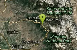
Chimney Rock
Tulare County, California
38.2 miles N of Tulare County, CaliforniaOne of the best places to go rock climbing in Sequoia National Park! There are a variety of routes that can be climbed here, with the routes ranging from 5.8-5.10. There are six granite formations that offer many different climbs from 1 pitch to 700 feet. The most popular route to climb is Chimney Rock Spire with 13 routes available to climb.
The area is closed from January 1 through August 1 for Falcon nesting.
Popular Routes
Duet: 5.8+, Trad, 3 Pitches, 200'
Wall of Early Morning Fright: 5.9, Trad, 2 Pitches, 300'
He's Got Marty Feldman Eyes: 5.10a, Trad, Sport, 2 Pitches, 300'
Kitty from Hell: 5.10d, Trad, 4 Pitches, 500'
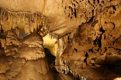
Crystal Cave
Three Rivers, California
11.0 miles NE of Three Rivers, CaliforniaThough Sequoia National Park is known for its famous trees and beautiful mountains, it also is well known for its caves. Many of California's caves that are over a mile long can be found in Sequoia National Park. There are over 200 caves within Sequoia and Kings Canyon National Park, though many are not fully accessible to the public, either for research purposes or equipment is necessary. The Crystal Cave is a marble cave system located within the heart of Sequoia National Park. Visitors can go on guided tours of varying lengths as they experience the beauty of life underneath the park.
Within Crystal Cave visitors will be greeted by smooth marble walls and sparkling stalactites and stalagmites. Flowing through different parts of the caves are streams and lakes, which helped to erode the cave walls and allow the cavern to form over time. There is a lighted walkway through the cave that visitors take during the tour.
There are multiple tours that visitors can take. The basic tour lasts about 45-50 mintues and takes visitors all throughout the cave on an easy to follow walkway. In the summer evenings there is the "Explorers Lantern Tour" which allows visitors to explore the cave by lantern light instead of the usual electric lights. On Saturdays, if you are feeling really adventurous, visitors can participate in the "Adventure Tour". This tour is between 4-6 hours, and includes crawling on your belly, squeezing through tight passageways, and go off the paved trail to get down and dirty. Equipment is provided, though be prepared to come out dirty!
The caves are open only during the summer months, though they are still cold inside regardless of the temperature outside. The average temperature inside the cave is about 50°F, so bring a jacket.
Prices as of 5/8/17
Famly Tour- 50 minutes
Adults (13+): $16
Youth (5-12): $8
Children (5 and under): $5
Discovery Tour- 1.5 hours, ages 12+
$18 per person
Wild Cave Tour- 4 to 6 hours, ages 16+
Limit of 6 people, $135 per person
Junior Cave Tour- 1 to 2.5 hours, ages 10 to 15
Limit of 6 people, $30 per person
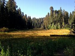
Crescent Meadow in Sequoia National Park
Sequoia National Park, California
11.3 miles NW of Sequoia National Park, CaliforniaCrescent Meadows is a gentle and easy hiking area, making it perfect for families. Inside the meadow area, visitors will see many of the large Sequoias and Redwoods, as well as a variety of wildlife. The meadow is one of the best places in the park to view wildlife, including the black bear.
Sights include Chimney Tree and Tharp's Cabin. Chimney Tree is a burnt out sequoia, which allows visitors the rare opportunity to stand inside of a giant sequoia. The bark on sequoia trees allows them to survive over 100 wildfires during the course of their lifetime. The Chimney Tree is not on the main trail within Crescent Meadows, but is well marked and easy to find.
Tharp's Cabin is a small log cabin built into a fallen sequoia tree. Hale Tharp was shown the area by Yukut guides in 1858 and severl years later built a log cabin in a fallen tree. This became his summer residence while his cattle grazed in the meadows. When the area became a national park, Tharp moved, but his cabin stayed. Visitors are able to go inside and see just how it was left, including Tharp's bed and table.
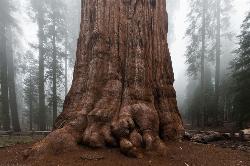
General Sherman Tree in Sequoia National Park
Three Rivers, California
13.0 miles NE of Three Rivers, CaliforniaWithin Sequoia National Park, the biggest attraction is General Sherman, the world's largest tree. It is believed that the tree is about 2,000 years old, and was named after the Civil War general, General William Tecumseh Sherman in 1879. Nestled in the section of the park, can drive or hike to the tree. There are walking trails that take visitors right up to the tree and allow them to marvel at the vast size of the tree. Two trails can take visitors to the tree, the General Sherman's trail and Big Tree's trail. A free shuttle is also available for visitors to take and runs from May through September each year.
The General Sherman Tree is the world's largest tree, measured by volume. It stands 275 feet (83 m) tall, and is over 36 feet (11 m) in diameter at the base. Sequoia trunks remain wide high up. Sixty feet above the base, the Sherman Tree is 17.5 feet (5.3 m) in diameter.Courtesy of nps.gov
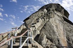
Moro Rock
Tulare, California
40.0 miles NE of Tulare, CaliforniaHike through the mountains of Sequoia National Park and you will come to Moro Rock, which offers views of the Great Western Divide. With 400 laddered stpes, you will feel like you are standing on top of the world.
The trail is about a quarter of a mile long, and the rock itself rises about 6,725 ft in elevation. There is a way for visitors to drive up to a parking lot where visitors will only have to hike about 300 ft to the top. The trail is not very wide, but should be hiked single-file. Along the trail there are a few ledges that might make the faint of heart a little worried, but they pass quickly! Stopping along the trail to catch a breath will reward visitors with amazing views. Along the trail there are information panels providing some history about the rock and surrounding areas, a little science about how the rock was formed, and a list of visible summits from Moro Rock.
The rock is also open to rock climbers, however during the summer the area is closed off for falcon nesting. There are many routes to climb, anywhere from 5.7 to 5.12. The rock is made from the same granite as Yosemite's Half Dome, and is mainly free climbing with some aid routes as well.
0.3 mi
 Full Listing
Hike
Added on 1 May 2017
Full Listing
Hike
Added on 1 May 2017
Glacier Point
Yosemite National Park
9.6 miles S of Yosemite National ParkLocated in Yosemite National Park, Glacier Point gives a birds-eye-view of the park you can't find anywhere else. It can be accessed by both hiking and driving through the park, though the roads may be closed until early to late May due to snow. Glacier Point towers over Yosemite Valley, sitting at 7,214 ft compared to the 4,000 ft valley floor.
From Glacier Point visitors are able to see the famous Half Dome, Vernal Falls, Nevada Falls, Yosemite Falls, El Capitan, and the Yosemite High Country. Each season offers a different view and feel for visitors. Come in the winter and you will see a snow covered Half Dome and High Country. Spring comes with the promise of new green leaves and roaring, snowmelt fed waterfalls. The summer still offers plenty of views, though a lot of tourists will be visiting. Fall brings a change of leaves throughout the park, and so it provides a beautiful contrast to the granite cliffs all around.
The trails to get to Glacier Point are the Four Mile Trail and the Panoramic Trail. The Four Mile Trail starts at the valley floor and like the name says, it is about 4.7 miles one way. Hiking up to Glacier Point has a significant level of elevation gain (Valley Floor is 4,000 ft and Glacier Point is 7,214 ft). The trail offers views of the Yosemite Valley that belong in a postcard. Those who hike to the top can enjoy an ice cream at the general store, while taking in the views. On the way down, hikers will see Yosemite Falls constantly in front of them, while the other sights of the valley floor come into view as the trail descends.
The Panoramic Trail is an alternative for going down from Glacier Point. Many hikers alternate between taking the Four Mile Trail up and the Panormaic Trail down (or vice versa). While the sights of the Four Mile Trail include many of the valley floor sights, the Panoramic Trail offers views of Illilouette, Nevada, and Vernal Falls. The trail ends at a different point than the Four Mile Trail, but hikers can take one of the free shuttles throughout the park.
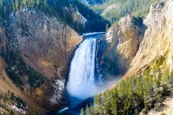
Lower Falls of the Yellowstone
Canyon Village, Yellowstone National Park
1.1 miles S of Canyon Village, Yellowstone National ParkLower Yellowstone Falls is one of the most popular places to visit in Yellowstone, coming in just behind the geyser, Old Faithful. The tallest waterfall in the park, Lower Yellowstone Falls is about 308 ft. Upper Yellowstone Falls feeds this waterfall and can be accessed through a trail before reaching Lower Yellowstone Falls. Because of a turn in the river, both waterfalls are not visible at one time, instead visitors can see just one waterfall at a time.
Both falls are located in a 20 mile long canyon nicknamed the Yellowstone Grand Canyon. The Yellowstone River feeds the falls and it is the longest undamed river in the continental United States. The canyon was created through water eroding the volcanic rock. Lower Yellowstone Falls is particulary beautiful because the large waterfall contrasts with the yellow "rusting" rocks that make up the canyon walls. The iconic "yellow" color in Yellowstone is from the many rocks that oxidize because of the rust and iron found in the rock.
The 308 foot waterfall is taller than Niagra Falls and has many lookout points, offering a variety of views from up close to miles away. There are several trails that can be taken to experience all the views, each with a parking lot before the trailhead. The trails are still open in the winter, however please be aware that they may be icy, as well there are steep drops and switchbacks. In the winter, the trails can only be accessed by snowmobile or snow coaches.
Following the Grand Loop Road, visitors will be able to see the waterfall and access the various trailheads. The summer time will be the busiest time as toursits from all over are enjoying the park. Spring and Fall are especially beautiful, however the road to access the falls opens in mid-April and closes in late October. Turning onto North Rim Drive, visitors will have access to all the view points on that side of the waterfall. The first viewpoint is the Brink of the Lower Falls. Visitors are able to get quite close to the falls, putting them right next to the mouth of the falls as the water goes cascading down below them. The trail is a steep hike down, but a must see. While right at the mouth of the waterfall, visitors can turn and look out at the canyon and see it continue on its 20 mile journey.
Next is the Lookout Point. This offers a panoramic view of the surrounding canyons and waterfall. Though it is several miles away from the actual waterfall, visitors can still hear the booming of water flowing over the falls. The Lookout Point is also the trailhead for Red Rock Point, which gives the closest full view of the waterfall for visitors. It is a steep trail as well, with a sign warning "A steep descent to Red Rock will take you to the North Rim’s closest full view of Lower Falls. Please be prepared for steep grades, steps, and a rough surface. The trail descends rapidly—about 500 feet (150 m) in 3/8 mile (0.6 km). Wear sturdy walking shoes with good tread, and be prepared for a steep uphill return".
Grandview is another lookout point along the North Rim Drive. It provides another panoramic view of Lower Falls, though not as close as the one found at lookout point.
Inspiration Point is the last viewpoint along North Rim Drive. Not much of the Lower Falls are visible from here, but a panoramic view of the canyon reminds visitors just how small they really are when compared to the towering canyon walls.
On the opposite side of the Lower Falls are two additional trails, Uncle Tom's Trail and Artist Point. Taking South Rim Road, visitors will first see the trailhead for Uncle Tom's Trail. This trail consists of 328 steel steps that take visitors about 3/4 of the way down the Canyon. Like the view from the Brink of Lower Falls, visitors will be very close to the falls as the water goes tumbling down below them.
Artist Point is one of the most photographed views in Yellowstone. It is a very easy hike with little elevation gain. Visitors will be awed when looking at the canyon from Artist Point, for it shows just how wide and deep the canyon has become from thousands of years of erosion.
New Hogan Lake
Valley Springs, California
1.4 miles SE of Valley Springs, CaliforniaBackpack, Camp, Hike, and Swim near Valley Springs, California
Full Listing
Backpack, Camp, Hike, Swim
Added on 24 Apr 2017
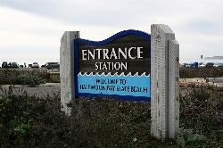
Half Moon Bay State Beach
Half Moon Bay, California
1.0 miles W of Half Moon Bay, CaliforniaHalf Moon Bay State Park's Coastside Trail runs parallel to the Pacific Coast along what used to be the Ocean Shore Railroad. The railroad itself was in operation for just 14 years before it was driven out of business in the early 1920s by the automobile. However, the railroad had a tremendous effect on the Northern California coastline. It opened the area to agriculture, created new communities along the shoreline and made the coastal beaches prime tourist destinations. The Coastside Trail is truly a destination trail. It offers sweeping views of the Pacific Ocean, access to several beaches and excellent nature viewing. Bird watching is quite good and a popular activity here. Red-tailed hawks, blue herons and red-winged blackbirds are spotted frequently, and large hawks can often be seen perched on benches and the trail's split-rail fence. Half Moon Bay State Beach is also home of the world-famous Mavericks, a surfing spot near Pillar Point that's visible from the trail. In winter, surfers can ride waves up to 80 feet high here.Courtesy of traillink.com
×


