


11 locations
Add Location
 Full Listing
Show more
Camp, Canoe, Disc Golf, Swim
Last visited on 18 Jul 2018
Full Listing
Show more
Camp, Canoe, Disc Golf, Swim
Last visited on 18 Jul 2018
 Full Listing
Show more
Camp, Canoe
Last visited on 18 Jul 2018
Full Listing
Show more
Camp, Canoe
Last visited on 18 Jul 2018
 Full Listing
Show more
Hike, Swim
Last visited on 31 May 2018
Full Listing
Show more
Hike, Swim
Last visited on 31 May 2018
 Full Listing
Show more
Disc Golf
Last visited on 7 Jun 2017
Full Listing
Show more
Disc Golf
Last visited on 7 Jun 2017
 Full Listing
Show more
Hike, Mountain Bike
Last visited on 6 Jun 2017
Full Listing
Show more
Hike, Mountain Bike
Last visited on 6 Jun 2017
 Full Listing
Show more
Camp
Last visited on 16 May 2016
Full Listing
Show more
Camp
Last visited on 16 May 2016
Beaver Dick Park
Rexburg, Idaho
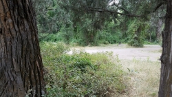
5.7 miles W of Rexburg, IdahoBeaver Dick is a park 4.5 miles west of Rexburg, Idaho on Hwy 33. It's a 9.5 acre park that passes next to the west bank of the Henry Fork of the Snake River; it's a popular place for swimming, fishing and other water activities such as boating and canoeing.
Within the campgrounds, there are fire pits, pavilions for social events and gatherings, bathrooms and a playground for the kids. It almost makes for good rounds of walks around the outskirts of the Snake River while enjoying the scenery.
History:
The park was named after an English-American named Richard Leigh. He was reportedly given the moniker "Beaver Dick" by LDS president Brigham Young for his beaver trapping abilities. As a young boy, he left England and moved to the United States to make a living as a fur trapper and eventually, fought in the Mexican war at 17 years old. He traveled throughout the Teton laying traps for beavers for fur, hunting and mapping out the Fire-Hole [Yellowstone Park], Jackson Hole and west of the Tetons in his journal. He became a fluent speaker of the Bannock and Shoshone language, met and married a native American woman named Jenny and had 6 children. The family adopted a child that contracted smallpox; the family of the child died. The family, including the adopted child, died of smallpox and Beaver Dick survived. He later remarried to a Bannock Indian named Susan Tadpole in 1979 and had 3 children. He lived the rest of his life as a mountain man but in 1899, he passed away of a serious illness and was buried beside his family overlooking his ranch in Rexburg, Idaho. He will be remembered as a skilled hunter, trapper and an expert in exploration and settlement of the Tetons, guiding travelers and explorers throughout the mountain west.
Tips:
-Bring water; there are no water fountains
-Bring life jackets in case of strong water currents during swimming
-Beaver Dick is open 7 days a week
-Make camping reservations in advance; first come, first serve
Camping Fees:
- $5 a night or $15 for all 5 day/night stays
For reservations, information, questions or concerns:
-Phone number: (208)-356-3139
-Website: https://www.co.madison.id.us/departments/parks-recreation/30-beaver-dick-park
The use of this field for playing paintball is now prohibited. Please take better care of the fields we are permitted to use.
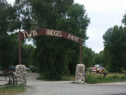
Twin Bridges Park
Rexburg, Idaho
10.5 miles S of Rexburg, IdahoTwin Bridges is a campground 12 miles South East of Rexburg on S. 600 E. It is maintained by Madison County Parks Department. It is a 27 acre park of pristine land rich with wildlife on the Snake River. The park is located between two bridges (from which it gets its name) has two entrances and has the rules that are posted at both the entrances. There are abundant camping spots with large trees for shade. The North, West, and East sides are surrounded by BLM ground that offers hunting, hiking, and site seeing. Camping is $10/night or $40/night for 5 sites. Camping is limited to 5 days in a 30 day period. The park is a dry park so pack plenty of water. Any camp or vehicles left unattended for more then 48 hours will be towed or taken down at owner's expense.
0.4 mi
 Full Listing
Show more
Hike
Last visited on 1 Jun 2018
Full Listing
Show more
Hike
Last visited on 1 Jun 2018
West Thumb Geyser Basin
Grant Visitor's Center, Yellowstone National Park
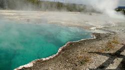
1.8 miles NW of Grant Visitor's Center, Yellowstone National ParkWest Thumb Geyser Basin is one of the smaller geyser basins in Yellowstone, yet its location along the shore of Yellowstone Lake and is ranked as the most scenic. This area was formed by volcanic explosion that took place more than 150,000 years ago. After the volcano exploded, the area collapsed and filled with water over time. It gets its thermal abilities from the enclosed magma trapped in the ring fractures that developed over time.In the 1990's several underwater geysers were discovered. These geysers can be seen as bulges underground, especially during the summer months. The basin is also special because of its location in Yellowstone. The West Thumb Geyser Basin is located on the edge of Yellowstone Lake.
This area features many other springs in the area. As surprising as it is, this area is also one of the least visited areas within Yellowstone. There are boardwalks all along the basin, making it an easy walk to see the beautiful hydrothermal springs in the area. West Thumb's name is derived from the thumb-like projection of Yellowstone Lake and the name was given by the 1870 Washburn Expedition. It was also known as Hot Spring Camp. West Thumb has less geyser activity than other basins. However, amazingly for its size it has all — hot springs, pools, mud pots, fumaroles and lake shore geysers.
Garden of Eden
Felton, California
2.0 miles SE of Felton, CaliforniaThe Garden of Eden is a beloved swimming hole tucked into the redwoods of Henry Cowell Redwoods State Park near Felton, California, in the Santa Cruz Mountains. Strung along the San Lorenzo River beneath towering redwoods and Douglas firs, this sun-dappled oasis — with its clear green pools, little sandy beaches, and rocky ledges — has been a favorite Santa Cruz summer escape for generations.
It's an idyllic spot to spend a warm afternoon: swim in the cool river, sunbathe on the rocks and small beaches, and watch the light filter down through the redwood canopy. Some ledges draw cliff-jumpers when the water is deep enough, though “No Diving” signs are posted for good reason — more on that below.
Getting there is a little adventure with an important catch: the most common route follows an active railroad line (the Roaring Camp scenic railway). From the Ox Trail parking area off Highway 9, you hike down and then walk along the train tracks for about a mile to reach the swimming hole. These tracks are active and trains do run — people have been seriously hurt and killed here. Stay alert, step well clear of the tracks whenever a train approaches, skip the headphones, and keep kids close. And heed the “No Diving” signs: always check the depth before entering, since the river bottom and water level change.
A few more notes: there are no restrooms or trash cans, so pack out everything you bring in, and dogs are not permitted. Arrive early on summer weekends, as roadside parking fills fast. Summer and early fall, when the river warms and the flow settles, are the best times to visit. Mind the trains, respect the river, and the Garden of Eden rewards you with one of the most beautiful swimming holes in the Santa Cruz Mountains.
1.3 mi
 Full Listing
Show more
Hike
Last visited on 31 May 2018
Full Listing
Show more
Hike
Last visited on 31 May 2018
Lady Bird Johnson Grove Trail
Orick, California
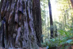
2.5 miles NE of Orick, CaliforniaThis is a short hike that surrounds you with greenery and beautiful, tall trees. As you hike through the grove, you may hear birds chirping, but you will mostly just hear your feet walking on the dirt trail. It is a quiet, peaceful place to go to escape the day-to-day noise.
For a major redwood attraction, this trail is, unusually, at 1200 feet above sea level. This ridgeside grove is spectacular because it is much more than shrubs and trees.The trees are very tall and the greenery that surrounds you is brilliant. This grove is free of noise from the city traffic because of it's elevation. It is often in the clouds and gets a lot more fog than lowland groves.
History of Location: President Richard Nixon, in August 1969, dedicated the grove to Lady Bird Johnson who was an environmental activist, women's right activist, as well as former first lady. Richard Nixon named the grave after Mrs. Johnson because of the beautiful works she accomplished in her life and how the grove echoed that sentiment.
This is a free attraction, about a mile and a half, round-trip, surrounded by lots of parking, and a visual trail guide is available for purchase, for a dollar.
0.1-0.9 mi
 Full Listing
Show more
Hike
Last visited on 31 May 2018
Full Listing
Show more
Hike
Last visited on 31 May 2018
Natural Bridges State Park / Monarch Butterfly Trail
Santa Cruz, California
2.0 miles SW of Santa Cruz, CaliforniaThis trail is perfectly tucked away from the business of Santa Cruz. Monarch butterflies, during the Winter, fly here to stay warm. As you walk through the Monarch Grove, you will see trees covered with butterflies. Their wings fluttering look like tree leaves blowing in the wind, until you take a closer look. It is a peaceful place to be as you learn about Monarch butterflies and watch them fly around.
Monarch butterfly migration begins at different times but they start arriving in the grove around mid-October. This is the perfect time of year to take a nice stroll on the boardwalk and watch the butterflies. The park is filled with eucalyptus trees which give the butterflies the perfect protection for them in the winter months. Since this is a preserve, it is asked not to grab or hold butterflies and to stay quiet to help continue making them feel safe. The end of the Monarch season is around mid-February. It is the perfect, family friendly location.
There is one main trail, but you can customize the length of your walk/hike depending on what you would like to do.
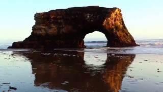
The trail leads to a beautiful sandy beach. You will see a huge, beautiful rock arch to your left of the beach. The water is refreshingly cool. Watching the sunset over the water, pulls out the orange colors of the arch rock making the scene bright and peaceful.
This is the perfect location to see shore birds, migrating whales, and playing otters offshore. As you continue to walk around the beach, you will come across tide pools where you can get a glimpse of sea life. The low tide allows visitors to see star fish and other sea animals. It is a great location for families to explore and enjoy their time together.
Important Information: There is a $10 vehicle day-use fee. The water is shallow enough for children to play safely, but it is necessary for parents to supervise their children because there aren't lifeguards on duty. Bikes are permitted on the paved roads around the park and beach. Dogs are also permitted on paved roads and in the park but not on the beach.
Ann Morrison Park Southeast
Boise, Idaho
0.8 miles S of Boise, IdahoGrassy well-maintained riverside park with flat terrain, trees, water hazards (swampy ditches). Alt. pin placements for all holes. Road tees are wheelchair-accessible, marked by paint. Summer course. Winter Course known as Northwest. Public (No Fee)Courtesy of DiscGolfUnited.com
Central Foothills
Boise, Idaho
1.3 miles NE of Boise, IdahoFrom foothills to mountain tops, Idaho's wilderness offers some of the best hiking in the country. With over 19,000 miles of trails, hikers can find everything from paved recreational trails to remote wilderness paths with steep, rocky inclines. Idaho even has several trails that are nationally recognized including The Idaho Centennial Trail, which extends approximately 1,200 miles from Nevada through Idaho up to the Canadian border. In 1990, it was officially designated by the Idaho Parks and Recreation Board and became the first trail to be adopted into the State Recreational Trail System.
Monkey Rock
Saint Anthony, Idaho
4.1 miles SE of Saint Anthony, IdahoCLOSED. PSA: Monkey Rock is no longer open to the public. The owner has posted "No Trespassing" signs and is asking the Fremont County Sheriff's Office to assist with keeping people out of their private property. We would like to remind those who may choose to ignore the "No Trespassing" signs that trespassing is a misdemeanor and will not be tolerated.
Full Listing
Show more
Swim
Last visited on 12 May 2017
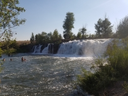
Monkey Rock features a beautiful waterfall you can wade right up to during the summer. Just under the waterfall is a great spot to wade around in or even some shallow swimming pretty good for small children. Maybe you just want to take advantage of the great bank to bask in the summer sun. The water temperature is fairly cool, which by no means is unwelcomed during the hot summer months. You'll get used to the water fairly quickly once you're in. The waterfall is a fun feature at Monkey Rock, not to mention a popular engagement photo backdrop. The name "Monkey Rock" is derived from the "monkeys" who jump off the rocks at the top of the falls to the pool below. Though not a great height, it's important to be careful and only jump into areas clear of rocks and other hazards and where the water is deep enough that you won't hit bottom when you jump. There really isn't a safe spot to jump from the falls as it doesn't usually get more than 5 feet deep.
The real jumping location is off the Hog Hollow Bridge up the road from the waterfall.
PLEASE NOTE: On the roads leading to Monkey Rock, the speed limit is 35 mph for the last mile. There are kids, cows, horses, and dogs along that road and many people tend to speed going to and from Monkey Rock. Please slow down and stay safe.
1.4 mi
 Full Listing
Show more
Hike
Last visited on 2 Feb 2017
Full Listing
Show more
Hike
Last visited on 2 Feb 2017
Table Rock
Boise, Idaho
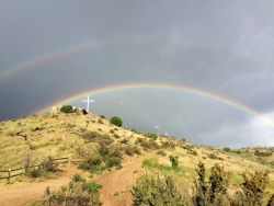
3.0 miles SE of Boise, IdahoTable Rock is located directly above downtown Boise, Idaho and is part of the extreme southwestern portion of the Boise Mountains. It is recognizable by the tall white cross, that lights up. If you're in Boise, this isn't an experience you want to miss. The view from the top allows you to look over Boise, and is the most beautiful as the leaves are changing colors in fall.
The two best times, to add to the experience, would to be either going before sunrise or sunset. Watching the sun rise is an emotional experience, especially after such a great hike. Or watching the sun set over Boise and watching the lights turn on all over the city, including the cross on the peak. The hike, or drive, offers grand views of the Boise skyline, foothills, and valley.
Pets are allowed on this hike, but they need to be on their leash. Don't let them run through the brush, especially suring summer months, where snakes hide in the brush. There are multiple paths to the peak, so choose your path before embarking on your hike. There are no fees for this hike.
WARNING: No fires or launching off fireworks from this location. It is too dry and can cause large wildfires. This happened in 2015, and the person who started the wildfire because of fireworks, which in turn burned homes, was convicted. Please be smart and use common sense, because this location is important and beloved by the citizens of Boise and other surrounding locations.
Wolf Flats Recreation Area
Ririe, Idaho
8.5 miles E of Ririe, IdahoWolf Flats Recreation Area is a free, undeveloped camping area strung along the South Fork of the Snake River in the canyon country east of Idaho Falls, and it's a longtime favorite of eastern Idaho anglers, floaters and campers who like their riverside nights quiet, cheap and close to the water. Managed by the BLM, it offers about 25 dispersed campsites, some large enough for groups of up to 50, scattered along a beautiful stretch of one of Idaho's premier trout rivers, with undeveloped boat access right there for launching a drift boat or raft.
The setting is the whole point. Many of the sites sit close to the South Fork, so you can camp to the sound of moving water, wake up steps from a world-class fishery, and push a boat onto the river without hauling it far. The South Fork here is renowned for its trout, and Wolf Flats makes an ideal, no-frills base for a fishing weekend, a float, or simply a riverside escape. Campers regularly spot wildlife, with marmots and foxes among the residents, and trails nearby lead to canyon views.
Getting there is simple: it's about 40 minutes east of Idaho Falls, roughly 6 miles past Heise along the Snake River Road. There are no fees at Wolf Flats, which is a rare and welcome thing, but that comes with the trade-off of no amenities: there is no drinking water and no trash pickup, though portable toilets are provided at the large main site.
Because it's free and undeveloped, the rules that keep it that way matter, and the BLM states them plainly. Burn only wood products in the fire pits (no metal, glass or plastic), do not cut down trees, use only small-diameter dead-and-down wood, and do not create new camping areas by driving into the vegetation off the designated routes. Following those keeps Wolf Flats open and pleasant for the next campers.
Summer and early fall are the prime season, with warm days for floating and fishing and cool river-canyon nights; spring runs high and cold on the river. As a dispersed area with no reservations, popular summer weekends can fill the best riverside spots, so arriving early helps.
Come fully self-sufficient: bring all your drinking water, pack out every bit of trash, bring your own firewood or gather only small dead-and-down, and carry a fishing license if you plan to cast this blue-ribbon water. For free, quiet, riverside camping with a boat launch on one of Idaho's best trout rivers, Wolf Flats is a genuine eastern Idaho treasure.
×


