


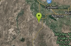
6 locations
Add Location
 Full Listing
Show more
Cross-country Ski, Hike, Kayak
Added on 11 Aug 2017
Full Listing
Show more
Cross-country Ski, Hike, Kayak
Added on 11 Aug 2017
 Full Listing
Show more
Camp, Cave, Hike, Kayak, Swim
Added on 11 Aug 2017
Full Listing
Show more
Camp, Cave, Hike, Kayak, Swim
Added on 11 Aug 2017
 Full Listing
Show more
Canyoneer, Hike, Rock Climb, Swim
Added on 11 Aug 2017
Full Listing
Show more
Canyoneer, Hike, Rock Climb, Swim
Added on 11 Aug 2017

Mesa Falls
Ashton, Idaho
10.0 miles NE of Ashton, IdahoUpper Mesa Falls, aka Big Falls, is an absolutely awesome waterfall on the Henrys Fork of the Snake River. The falls drop 114 ft. and measure 300 ft. across. To get to the falls from the parking lot is 0.2 miles of paved walkway and several sturdy stairs with plenty of gaurdrails and handrails. There are several platforms along the route for viewing and taking photos. Catch it in the morning to see the rainbows in the lingering mist that often rises well above the platforms. There's a wheelchair accessible path that can get a pretty good view of the falls but does not go right down to it.
Lower Mesa Falls is about a mile down river from the Upper Falls. There's two great viewing options. One is from a cliff hovering 200 feet above the falls and the other is from the the Observation Site sitting 0.25 miles away and almost 500 feet above the falls. To get to the cliff above the falls, there's a trailhead on the South East end of the main parking lot. The trail is 1 mile each way (2 mile out and back) with about a 100 ft. difference in elevation (about the same as the stairs the the Upper Falls platforms). The trail goes through the woods well away from the river itself but there are no guardrails at the end when you're peering over the edge of the cliffs to see the waterfall. To see the falls from the observation site is free and the walk from your car to the lookout is only about 500 ft.
This is an Idaho State Park and there are day use fees. Passes have reciprocity with Harriman State Park which is only about 20 minutes away. Get there before 5pm to check out the old inn which has been transformed into a fun and informative visitor's center.
Fall Creek Falls
Swan Valley, Idaho
2.1 miles SW of Swan Valley, IdahoFall Creek Falls is one of eastern Idaho's most beloved and photographed waterfalls — a broad, 60-to-70-foot curtain of water that spills over mossy travertine ledges directly into the Snake River near Swan Valley. It's a genuinely unusual sight: most waterfalls tumble into a creek or pool, but this one pours straight into a major river, framed by the cottonwoods and canyon walls of the beautiful Swan Valley. It's especially glorious in autumn, when the riverside trees blaze gold and the whole scene lights up.
The best part for most visitors is how easy it is to reach. From Highway 26 just west of Swan Valley, turn onto gravel Fall Creek Road (Forest Road 058) and follow it along the Snake River to a small pull-out near the falls. From there it's more of a short walk than a hike — cross a small stream and stroll a couple of minutes to a flat perch right at the top of the falls, with sweeping views over the waterfall and the river beyond.
Adventurous visitors can scramble down for a closer look. A steep, sandy slide and a set of natural rock steps lead down toward the base, where you'll find a mossy grotto tucked behind and beneath the falls — a magical little chamber where you can stand in the cool mist and shade with the water curtaining down in front of you. The ceiling is low, so watch your head, and the rock steps kick up far less dust than the loose slide.
Be careful near the edges. The viewpoints at the top sit right above the falls, with abrupt, unrailed cliff drops of 10 to 15 feet in places, so keep well back from the lip and hold onto children — the rock can be slick near the water. The short scramble to the bottom is steep and can be slippery too.
The falls are a favorite of paddlers, too: because the water spills right into the Snake, kayakers and rafters floating this stretch below Palisades Dam can pull up close to the base for a view you can't get any other way. In winter the falls partially freeze into curtains and columns of ice, drawing photographers to the snowy canyon. However you come at it — on foot from the road above or by boat from the river below — it's a quick, high-reward stop between Idaho Falls and the Wyoming line.
The falls run year-round and reward a stop in any season, though flows are fullest with spring snowmelt and the color is best in fall. For photographers, midday sun is harsh out here; early morning or evening light is far kinder. Keep an eye on the river, too — boaters and rafters drift past below, and the area teems with wildlife, including the American white pelicans that cruise this stretch of the Snake. A Forest Service campground and public boat ramps sit nearby, making it easy to turn a quick stop into a longer stay. Bring water and sturdy shoes, and enjoy one of those “how have I never seen this before?” Idaho gems.
Jump Creek
Marsing, Idaho
7.1 miles SW of Marsing, IdahoJump Creek Falls is a surprising desert oasis in the Owyhee canyonlands southwest of Marsing, Idaho — a beautiful 60-foot waterfall pouring into a clear pool, tucked into a lush, rocky canyon that feels worlds away from the surrounding sagebrush high desert. Managed by the BLM and drawing more than 40,000 visitors a year, it's one of southwestern Idaho's most beloved short hikes and swimming spots.
The payoff comes fast. An easy trail of only about half a mile round trip leads up the canyon — a little rock-hopping and wading may be required — to the base of the falls, where a refreshing pool invites a cool dip on a hot day. The canyon is draped in water birch and red-osier dogwood, alive with birds and greenery, and there's also a Falls Overlook trail for those who'd rather stay high and dry. Rock climbers come for the canyon walls, too.
A few things to know. Poison ivy grows thick in spots along the creek and trail, so learn to spot it and give it room. The recreation area's posted hours are strictly enforced (due to past problems), and the lower parking area is closed in winter, roughly November through March. As always, pack out everything to protect this fragile desert canyon.
Spring and early summer are the most beautiful, when the falls run full and the canyon is greenest; summer is prime for swimming. To get there from the Marsing area, follow Highway 95 past the US-95 junction, turn onto Cemetery Road and then Jump Creek Road, and follow the signs to the gravel parking area. Bring water shoes, sun protection, and plenty of water, and enjoy one of Idaho's most rewarding little waterfall hikes.
0.1 mi
 Full Listing
Show more
Cave, Hike
Added on 11 Aug 2017
Full Listing
Show more
Cave, Hike
Added on 11 Aug 2017
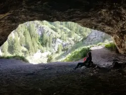
40 Horse Cave
Firth, Idaho
11.9 miles E of Firth, Idaho40 Horse Cave is a fun, family-friendly cave tucked into the rocky walls of Wolverine Canyon, on public BLM land about 15 miles from Firth, Idaho. It's reached by a scenic drive up well-maintained Wolverine Road, with a parking area a couple of miles into the canyon, and there are no fees. The cave gets its colorful name from a pair of local legends — one tells of two men caught in a storm who ducked inside, one remarking that “this cave could hold about 40 horses”; another claims a thief once stashed 40 stolen horses here to avoid capture. Either way, the roomy opening makes the tall tale easy to believe.
The hike up to the cave is short but steep — only about 500 feet long with roughly 100 feet of climbing, yet it earns every step. There are two ways up: the shorter, more direct route is a loose shale scramble that's genuinely slippery (hikers and kids alike tend to slide around, even in good boots), while the slightly longer trail is still steep but holds much less shale and makes for a far easier descent. A common strategy is to grind up the short shale route and come down the gentler one.
Inside, the cave runs only about 25 to 50 feet deep, so a flashlight isn't strictly required — but a few nooks and back corners are more fun to poke around with a light, and kids can easily spend half an hour or more exploring. Keep an eye out for the rock chucks (yellow-bellied marmots) that sun themselves on the boulders around the canyon.
There's more to discover nearby. At the bottom of the trail, a culvert near the road becomes a fun place to splash around when the creek is running high. And if you follow the faint trail in the willows on the southeast side of the road for about 100 feet of easy walking, you'll find a smaller second cave worth a look.
Wolverine Canyon itself is worth the trip. Its rugged rock walls draw rock climbers, the creek and cottonwoods make for pleasant camping and picnicking, and the quiet canyon is good for wildlife watching — deer, raptors, and those ever-present marmots. Many families make a half-day of it, combining the cave with a creekside lunch and a wander among the canyon's formations.
A few practical notes: Wolverine Road is usually in good shape, but it can occasionally be closed to vehicle traffic, so it's worth checking conditions before a long drive. The canyon is a shared landscape of public land and working ranches, so respect any private property and livestock you encounter, leave gates as you find them, and pack out your trash. Bring water, sturdy shoes with good grip for the shale, and sun protection, and enjoy one of eastern Idaho's most enjoyable little cave adventures.
0.3-0.6 mi
 Full Listing
Show more
Hike
Added on 11 Aug 2017
Full Listing
Show more
Hike
Added on 11 Aug 2017
Cress Creek Nature Trail
Rexburg, Idaho
11.9 miles S of Rexburg, IdahoMeandering along the scenic South Fork of the Snake River, the beautiful 1¼ mile Cress Creek Nature Trail will lead you on a journey through sagebrush-grass communities, over juniper covered slopes, and along a lush perennial creek. Cress Creek derives its name from the watercress plant, a favorite food of the moose that live in this area. With clear skies, prepare for an expansive view of the Snake River, volcanoes and farmland. The site offers ample parking, restrooms and trail accessibility, which attract a wide spectrum of trail users to the area. You will become familiar with life in the Cress Creek area as it is now and as it was long ago. If you hike quietly you may see deer, rabbits, small lizards, or possibly an eagle or a moose. The nature trail is self-guided with many beautiful interpretive signs posted along the way to assist you. The first half-mile of the trail is accessible by wheelchair.
On the northeastern corner of the trail, there's an overlook trail. Parts of it are pretty nice like the rest of the loop but some is barely recognizable as a trail. Parts of the trail are steep and parts of it go over some pretty loose rock. It goes for about a ½ mile all the way to the top of the hill. Just below the rim, there are several really cool caves. From the top, you can see from Rexburg to Idaho Falls.
Monkey Rock
Saint Anthony, Idaho
4.1 miles SE of Saint Anthony, IdahoCLOSED. PSA: Monkey Rock is no longer open to the public. The owner has posted "No Trespassing" signs and is asking the Fremont County Sheriff's Office to assist with keeping people out of their private property. We would like to remind those who may choose to ignore the "No Trespassing" signs that trespassing is a misdemeanor and will not be tolerated.
Full Listing
Show more
Swim
Added on 11 Aug 2017
Monkey Rock features a beautiful waterfall you can wade right up to during the summer. Just under the waterfall is a great spot to wade around in or even some shallow swimming pretty good for small children. Maybe you just want to take advantage of the great bank to bask in the summer sun. The water temperature is fairly cool, which by no means is unwelcomed during the hot summer months. You'll get used to the water fairly quickly once you're in. The waterfall is a fun feature at Monkey Rock, not to mention a popular engagement photo backdrop. The name "Monkey Rock" is derived from the "monkeys" who jump off the rocks at the top of the falls to the pool below. Though not a great height, it's important to be careful and only jump into areas clear of rocks and other hazards and where the water is deep enough that you won't hit bottom when you jump. There really isn't a safe spot to jump from the falls as it doesn't usually get more than 5 feet deep.
The real jumping location is off the Hog Hollow Bridge up the road from the waterfall.
PLEASE NOTE: On the roads leading to Monkey Rock, the speed limit is 35 mph for the last mile. There are kids, cows, horses, and dogs along that road and many people tend to speed going to and from Monkey Rock. Please slow down and stay safe.
×


