5 Bucket List by jmeecakes
first prev 1 next last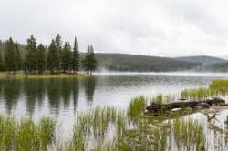
Dog Lake and Lembert Dome
Yosemite Valley, CA
17.2 miles NE of Yosemite Valley, CAThe hike to Dog Lake is often paired with the hike to Lembert Dome, because the two are so close in proximity. Each hike by itself is 2.8 miles round trip, but Lembert Dome has an elevation gain of about 800 feet as opposed to Dog Lake's 600 feet. To do both of them together, it's about 4 miles round trip.
Dog Lake and Lembert Dome are in the Tuolumne Meadows area of Yosemite's backcountry, meaning there are tons of surrounding wildflowers and beautiful scenery along the way. Because they are both such short lakes, even when done together, it usually only takes about 1.5-3 hours to complete. It's a great last minute option if you find yourself having some extra time during your trip. The lake is surrounded by evergreen trees, granite mountains, and wildflower meadows.
It's a fairly steep trail, and climbs pretty consistently until it reaches a junction. Turn left at the junction to reach Lembert Dome, where you'll receive an awesome view of Tuolumne Meadows. To reach Dog Lake, continue straight at the junction.
The trail is open as long as Tioga Road is open, which is typically June to November. Remember to stay off the domes during thunderstorms.

Glen Aulin
Glen Aulin, California
0.3 miles SE of Glen Aulin, CaliforniaThis trail is a popular route to take in the Yosemite High Country because it is a good introductory hike into the backcountry. At the end of the hike there are several waterfalls as well as a High Sierra Camp to stay at. This can be done as a day hike to the High Sierra Camp, and visitors can then enjoy a good meal and a nice tent. If hikers do not wish to pay the fee for the meal service/provided tent, there are several backpacker campsites throughout the site as well.
The majority of the trail will follow the Tuolumne River as it meanders through the Tuolumne Meadows and up into the High Sierra. Once reachingn the Glen Aulin camp, the beautiful White Cascade waterfall will be right next to the camp. Most visitors will use this camp as a basecamp for their adventures because the area has so many cool places to explore. One area that is popular to go to is Waterwheel Falls, which passes through a unique granite canyon. Outside of the camp and part of a different day hike is a trip to the Grand Canyon of the Tuolumne. Many people will also enjoy a quick swim in the river, depending on how swift the current is.
There is plenty of wildlife to see, especially when the trails first open. Usually the trail will be open once road access is cleared to Tuolumne Meadows. Because of elevation, the flowers will bloom later than flowers found in Yosemite Valley. Also due to elevation, the High Country will be much cooler during the summer than in most places in the park.
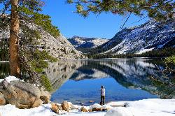
Tenaya Lake
Yosemite Valley, Yosemite National Park
9.3 miles NE of Yosemite Valley, Yosemite National ParkTenaya Lake is one of the most visited destinations in Yosemite National Park. The lake is easily accessed by Highway 120/Tioga Pass road which runs along the north shore of the lake. On the east shore of the lake is a very large beach where most people will enter the lake to go swimming, canoeing, and kayaking. The road to the lake normally opens up in May, though depending on snow it might be later, and stays open until October.
This lake is surrounded by beautiful scenery and hiking trails. One of the most popular trails for visitors to take is the Cloud Rest/Sunrise Lakes trail because it offers the best views of the lake and adjacent mountains. Like all of Yosemite, the area surrounding Tenaya lake was formed by glaciers and includes some beautiful granite peaks and domes. From the west end, visitors will be able to see Polly Dome, Pywiack Dome, and Mount Conness.
When the road to the lake is open, many people enjoy driving up and enjoying all of the hiking and views nearby. The mountains and peaks nearby offer plenty of hiking and climbing trails for all abilities.

May Lake
Yosemite Valley, Yosemite National Park
8.9 miles NE of Yosemite Valley, Yosemite National ParkMay lake is a relatively small lake that rests at the base of Mt. Hoffman in Yosemite National Park. One of the park's most scenic lakes, May lake not only gets up close and personal with beautiful granite cliffs, but it sits at an elevation of 9,270 feet and offers views of both Clouds Rest and Teyana Lake.
The hike to May Lake is only 2.5 miles round trip, but it has an elevation gain of 500 feet, so it climbs pretty steadily upward. Many visitors choose to hike both May Lake and Mt. Hoffmann, which adds 3.5 miles and about an extra 1500 feet of elevation to the hike.
Mt. Hoffmann sits at an elevation of 10, 845 feet and offers views of Clouds Rest, Half Dome, the northern Yosemite wilderness, and views of May Lake from above as well.
Charles Hoffmann allegedly named the mountain after himself and the lake after Lucy Mayotta Brown back in 1867. Three years later, the two were married.
Because the trailhead starts on Tioga Road, this hike is usually closed in the winter, so be sure to check road conditions before you embark. Also remember to pace yourself as you gain elevation and the oxygen gets thinner.

Mirror Lake
Yosemite Valley, Yosemite National Park
2.4 miles E of Yosemite Valley, Yosemite National ParkMirror Lake is a seasonal lake situated in a secluded corner of the beautiful Yosemite Valley. The lake sits at the base of Half Dome and allows a different perspective of the famous monolith. Hikers will also have the chance to see the Tenaya Canyon, Mount Watkins, and Washington Column. Because the lake is seasonal, the best time to visit is in the spring or early summer, when all the snowmelt is running through the area. When the water is calm, hikers will be able to understand why the lake is called Mirror Lake: the still reflection shows the surrounding cliff faces and the crown of Half Dome. If visiting in the late summer, fall, or winter, Mirror Lake becomes Mirror Meadow, filled with grasses and other plant life as well as snow.
The trail is a very easy trail and can be done with the whole family. It is 2 miles round trip to the lake and back, but can be up to 5 miles round trip if taking the loop around the lake. The shorter trail to the lake can be completed in about an hour, and 2-3 hours if doing the full loop. The trail is paved and open only to hikers or biking. Cars are not allowed on the trail, however there are numerous shuttles in the Yosemite Valley that can take hikers to the trailhead.
In the summer the lake becomes a very popular swimming hole, and attracts a lot of visitors. Another attraction to the lake is a small area where previous visitors have left cairns (stacks of rocks usually designating a trail). This "cairn garden" seems to grow with more and more cairns added each year. There is a wide variety from tall cairns to small (smaller than a baby) cairns. It is always fun to walk through the area and see what random places a cairn has been placed, as well as collect some rocks to make your own.

Merced River
Yosemite Valley, Yosemite National Park
0.6 miles SE of Yosemite Valley, Yosemite National ParkThe main fork of Merced River at Yosemite National Park is a perfect place to fish, swim, raft, and even pan for gold.
The river circles around the center of Yosemite Valley, and almost every point on the river has views of the most breathtaking parts of the park, from Yosemite Falls to Glacier Point.
Merced River is one of the few places in Yosemite that offer whitewater river rafting. The rapids go from Redbud to Briceburg and range from levels 2 to 4. It's a class IV run at peak snow melt, but it does get lower and slower as the season goes on. There are also several pullouts along the river canyon where people can get their own flotation devices and float the river themselves, although it's not recommended until late June, when the river has slowed down a bit.
It's also around this time that many people choose to go swimming in the river. The main fork is the ideal place for this. There are several places to camp along the river, such as Dirt Flat, Dry Gulch, McCabe Flat, Willow Placer, Railroad Flat, and more.
Fishing is also a favorite activity of those who come to the Merced River, but there are a few more conditions on fishing than usual. Catch and release is strongly encouraged, and only fish larger than 12 inches can be taken from the river.

Lukens Lake
Tuolumne Meadows, Yosemite National Park
13.9 miles W of Tuolumne Meadows, Yosemite National ParkLukens Lake is a small lake in the White Wolf area of Yosemite National Park. The hike is a short, 1.6 mile walk through a forest to the secluded lake surrounded by trees and a small wildflower meadow. This lake is famous for the luminescent shooting stars that are easily spotted while swimming here, so although it's not the most popular lake in the valley, it's not uncommon to have company while you're there.
There are two separate trails that will take you to Lukens Lake, one is 1.6 miles and starts from Tioga Road, and the other is 4.6 miles and starts from the White Wolf Lodge. Both trails have a low elevation gain, about 200-300 feet, and lead you through some pretty thick woods until you reach the lake. The longer trail crosses the Middle Fork of the Tuolumne River has a few more wildflowers and streams, but mostly it's just a longer walk in the forest.
The best time to visit is in July, when the wildflower meadows are at their peak. Tread carefully, though, because the trail is typically wet and muddy until August. It's also important to stay on the marked path so as not to damage the meadows.
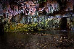
Natural Bridges
Sonora, California
6.8 miles NW of Sonora, CaliforniaNatural Bridges is well known among the locals of Calaveras County. Calavers itself has many caverns throughout the mountains, but most are fee based. Natural Bridges however, is open to the public and does not cost anything! The Coyote Creek runs through the cavern and has been the force creating the cavern. During the summer this is a popular place to visit as many people are able to float down the creek as well as jump in for a cool swim. The cavern itself is 250 ft long, going from one end to the other. Depending on water levels, visitors are able to float or swim through the limestone cavern and experience the deep pools and cool ceilings. If entering the cave, avoid touching the walls as the oils from human skin can disturb the growth of the limestone walls.
There are also several trails that visitors can take if they want to go into the cavern or explore on top of the bridge. Overall, there is more to see here than what first meets the eye.