


2.7K Bucket List by katelocke
first prev 1 next last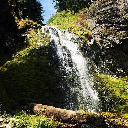
Plaikni Falls
Chiloquin, Oregon
24.5 miles NW of Chiloquin, OregonThere's more to Crater Lake National Park than the lake itself. If you want to get away from the more popular hiking trails and scenic routes, Plaikni Falls trail is a great alternative! It is definitely one of the more remote hikes at Crater Lake. This hiking trail is extremely family friendly and wheelchair accessible for the most part. This short hike leads you to the beautiful 20-foot waterfall and Sand Creek. This area is usually teeming with wildflowers in the prime summer months.
The Plaikni Falls trail is one of the newer trails at Crater Lake. It opened in 2011 and was intended for people with limited mobility and families with young children.
Along the trail, you will be surrounded by fir and hemlock trees which provide some nice shade during the hike. Make sure to bring a camera so that you can capture the great scenery you'll see!
Roundtrip: 42 minutes / 2 miles
Elevation gain: about 180 feet
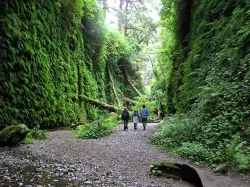
Fern Canyon
Orick, California
7.9 miles N of Orick, CaliforniaFern Canyon is one of the best 1-mile hikes that you can do in California! This unforgettable location was featured in Steven Spielberg's film, Jurassic Park: The Lost World.
Fern Canyon is located in Prairie Creek Redwoods. It's not incredibly easy to find, but the remote 8-mile drive will be worth seeing this fern laden paradise. Two stream crossings will need to be done by car, but one of these streams can be about 6 inches deep. If you don't think your car can make it, you'll just have to park and walk an extra mile.
Since this drive is pretty much in the middle of nowhere, you may see a lot of wildlife. You will most likely see a lot of elk on this drive so it's important to drive slowly on the dirt road. Also be aware of potholes along the road.
The drive is the most difficult part of this trip, so the hike is going to be a piece of cake in comparison. There is a parking lot with a vault toilet and a sign giving information about the area. The level trail begins at the top of the parking lot and leads you through a small, moss-covered forest before you reach the canyon. Be prepared to get wet during your hike because you will have to cross more streams. Don't try to find a way around the water and just have fun with it. Since the trail is relatively flat, this hike is a perfect, fun adventure for those with small children. There are a few wooden foot bridges here and there to cross some of the streams, but it is probable you will get your feet wet at some point.
Once you reach the canyon, you will have 50-foot canyon walls towering over you. These walls have lush, green plants cascading down the sides and there are fallen redwood trees, green with moss. You will possibly have to climb over or under a few logs. Along the canyon walls, there are some little waterfalls and streams that trickle down through the foliage. You will feel as if you are walking through a rainforest in Fern Canyon. No wonder a scene from the Jurassic Park movie was filmed here!
Going through the canyon itself is only about a half a mile, but the trail continues on and flattens out again into a forest. You can hike the whole loop trail or you can go back the way you came if you want to experience the canyon again (who wouldn't?).
Make sure you add this magical place to your list of places to see!
NOTE: Leave early in the morning to avoid the crowds. Bring water shoes or sandals.
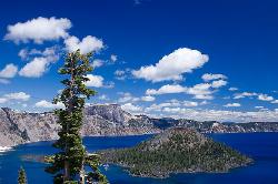
Wizard Island Summit Trail
Crater Lake National Park
4.6 miles N of Crater Lake National ParkWizard Island is one of the most interesting features of Crater Lake itself! It's considered one of the most magnificent volcanic cinder cones in the world. Take a boat tour to the island and experience its grandeur while hiking the Wizard Island Summit Trail! At the top, you will find the crater named Witches Cauldron.
Created by a violent eruption of Mount Mazama about 7,700 years ago, Wizard Island is located at the west end of Crater Lake. Although there are other cinder cones in the lake, Wizard Island is the only one to reach above the surface. The island rises about 755-feet above the lake.
The only way to get to the island is to hike down the Cleetwood Cove trail to the dock for boat tours. It's a 45-minute boat ride to Wizard Island where the trail to the summit begins. The beginning of the trail is very rocky with lava rock, but after about 10 minutes, the trail smooths out. The hike is about 2.5 miles total, which takes you around the 400-foot wide crater at the top.
Round trip: 4.5 miles
Elevation gain: about 765-feet
NOTE: There is a fee for the boat tour.
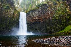
Abiqua Falls
Scotts Mills, Oregon
9.2 miles SE of Scotts Mills, OregonThis rough hiking trail will be well worth your effort and time. Although the trail is unmarked, there is a rope to steady yourself on the steep parts of the hike and guide you through the forest. Don't rely on your GPS to get you to the waterfall because you likely won't have cell reception. The waterfall is located on private land but is currently available to visitors who take the "trail". Finding the trailhead may be a bit problematic and will take a bit of off-roading to find, so again, don't completely rely on your GPS to find it for you. If you see a white sign on a tree or some arrows carved into a tree, you're going the right way.
This is a very steep hiking trail and becomes very slick, especially in the colder and rainier months. Some areas are very rocky and will require you to climb over big rocks and a few fallen trees. The trail ends at a basalt bowl with the breathtaking Abiqua Falls plunging into it. This is a hidden gem that is similar to the fall formations at Silver Falls State Park. Many people love taking pictures of this beautiful area. Facing the 92-foot waterfall, you will feel as if you are enclosed in a deep, mossy canyon. Also, if it's warm enough, people wade into the chilly water and get closer to the falls. Depending on the time of year, the water can be deep enough to swim in.
It is not recommended to bring small children or dogs on this hike because the climb back up is very steep and is difficult enough for the average person to just pull themselves up the ascent by the ropes.
Due to the difficulty of this hike, the fantastic destination at the end will surely feel very rewarding!

Malibu Creek State Park
Calabasas, California
4.8 miles SW of Calabasas, CaliforniaMalibu Creek State Park has something for everyone! Just 25 miles from downtown Los Angeles, the park features hiking, fishing, bird watching and horseback riding opportunities. There are 15 miles of streamside trail through oak and sycamore woodlands on chaparral-covered slopes. Twenty-five mile Malibu Creek in the park is the principal watercourse of the Santa Monica Mountains, from Boney Mountain to Malibu Lagoon. The park was the center of Chumash Native American life for centuries and was once used to film numerous movies and TV shows, such as Planet of the Apes and M*A*S*H.
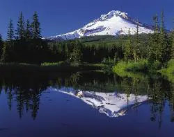
Mirror Lake Trail
Government Camp, Oregon
1.8 miles W of Government Camp, OregonThis family-friendly hiking trail leads to the beautiful Mirror Lake. It gets the name because it reflects Mount Hood in the still, glacier cirque lake. You will walk through a dense forest and have multiple opportunities to see excellent views of Mount Hood!
Although this is a heavily used trail due to its popularity and trailhead convenience next to the highway, Mirror Lake and the other Mt. Hood views are a MUST-SEE! You'll definitely want to bring a camera for the picturesque scenery!
Once you get to the lake, you can choose to take the loop around the lake which would make a longer hike, or you can just turn back and return the way you came.
Roundtrip: about 3.2 miles (with loop)
Elevation gain: about 700 ft
Difficulty: Easy

Tamolitch (Blue) Pool
Mount Washington, Oregon
9.4 miles W of Mount Washington, OregonThe Tamolitch Pool, also known as the Blue Pool, is the one and only pool of its kind in Oregon. The name "Tamolitch", meaning 'bucket', was given to this gorgeous basin by the Northwest Indians. This pool is created by the Mckenzie River which seeps through underground lava fields for two miles before emerging to the surface. As the river water seeps up from the porous lava, it gives the water in the pool a unique turquoise color and amazing clarity! This mesmerizing, clear blue water attracts many hikers, mountain bikers, and photographers. Despite the water that gushes out of the pool and returns to the Mckenzie River, the pool is so still and calm that it gives the illusion of a glass surface. This pool has become a popular place for photographers of all skill levels. It has gotten more recognition because of exposure on social media from visitors. The Tamolitch and McKenzie River trail are heavily used and have gained more and more visitors over the last few years.
It is not against the rules to jump into Tamolitch Pool. However, extreme caution is advised. Due to the clarity of the pool, those who jump in cannot make an accurate estimate of where the shallow areas are. The steep cliffs that surround the basin range from 10 - 60 feet. The water stays a chilly 30-some degrees all year round. Please jump from the cliffs at your own discretion.
The McKenzie River Trail is 26 miles if you hike the entire trail. To get to the "Blue Pool" is about 2 miles from the Tamolitch trail head. This hike is very scenic with great views of the McKenzie River with many photo opportunities along the way. The hike to Tamolitch is relatively easy with a well-maintained trail. The first part of the hike will be fairly flat but gets very rocky and a bit more steep the further you go. You will be able to see stunning views of the river from above as you hike.
Once you get to the pool, you can stand at the top of the cliffs and look down into the blue basin, or you can clamber down the steep lava rocks to the edge of the pool. On the other side of the pool, there is a way to get to the water's edge that isn't as steep.
NOTE: Although people do jump into the pool, it can be very risky. Many people have been injured and a few have even died by jumping in.
To the pool: about 2 miles
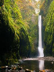
Oneonta Gorge
Cascade Locks, Oregon
10.5 miles SW of Cascade Locks, OregonThis unique hike is one of the many incredible experiences you can have in Oregon! It is located near Horsetail Falls which is another great hike to add on to this one if you would prefer a more lengthy outdoor excursion. You will definitely want to bring some water sandals and maybe an extra set of clothes for this adventure!
As soon as you reach the "trailhead" you will soon figure out that there isn't a designated trail for this hike. You will be required to climb over a log jam, tread through chest deep water (which can be quite cold at times), and hike through a narrow canyon over loose river rock and smooth pebbles covering the creek bed. Once you are in the gorge and see the moss and lichen covered rock towering above you, you'll feel as if you have gone to another world. There is something so surreal about walking through this mossy, green slot canyon adorned with ferns. It's like looking at a scene from a movie.
This hike is not for the faint of heart due to it being a bit challenging and strenuous. You won't be able to avoid getting wet during this hike and the water is typically fairly chilly!
It is also advised that you don't bring along small children unless you plan on carrying them. This would not be considered a family friendly hike.
NOTE: Depending on the time of year and your height, the water could be deeper or shallower than stated in the description.
TIP: To avoid the crowds, go sometime during the week rather than on the weekends. Going in the morning could also help you to avoid the rush of people who go later in the day when it gets warmer.
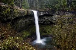
Silver Falls State Park
Sublimity, Oregon
7.6 miles NE of Sublimity, OregonSilver Falls State Park is a forested canyon that features 10 amazing waterfalls throughout the park. It is the largest state park in Oregon and one of the most popular, both nationally and internationally. People come from all over to witness the beauty of these splendid waterfalls at this unique and amazing park. It's less than an hour east of the Salem state capital in the green foothills of the Cascade Mountains.
At the South Falls, you can walk in awe behind a 177-foot waterfall. It's a part of the Trail of Ten Falls which is a breathtaking and nationally recognized hiking trail. This trail winds through lush, dense forested landscape and along a canyon where you will see many gorgeous waterfalls from different vantage points. You descend the trail following a serpentine creek to the forest floor. Photographers of all skill levels love to come to Silver Falls to capture the picturesque, scenic views it has to offer.
The full loop to hike all 10 waterfalls is about 7.2 miles and is considered a moderate hike with an elevation change of 800 feet. There are connecting trails that can make the hike shorter if one so desires. The park provides over 25 miles of backcountry trails for the outdoor enthusiast to enjoy.
Besides hiking, many visitors enjoy mountain biking, horseback riding, as well as camping at Silver Falls. The campground has tent and RV sites as well as cabins. If you bring a horse, there is a horse campground for you to stay at. There are also group tent and RV sites for larger groups and ranches that can sleep 75 people in dormitory-style bunkhouses.
The South Falls Day Use Area has open lawns, picnic tables, and shelters, barbecue stands, a playground, horseshoe pits, and an off-leash area for dogs. This area is frequently used for potlucks, family reunions, and even weddings.
(No pets are allowed on the Canyon Trail for everyone's safety. Pets on a leash can be on all other trails)
A $3-per-car fee is charged to park anywhere in the state park.
NOTE: It's important to remember that bears and cougars live in the more remote areas of the park.
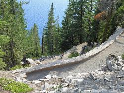
Cleetwood Cove Trail
Crater Lake National Park, Oregon
8.8 miles NE of Crater Lake National Park, OregonCleetwood Cove trail leads to the Wizard Island boat tour dock as well as a popular cliff jumping spot in Crater Lake National Park. This is the only legal and safe place for visitors to access the shoreline of Crater Lake. Hiking the trail to the shoreline is quite steep and difficult. It is a switchback trail that shouldn’t be attempted by those with heart conditions or other health problems. The hike is considered strenuous and is about an hour and a half to the shoreline, and can take over two hours on the way back.
This trail provides gorgeous views of the lake and is primarily used for hiking and trail running. It's advised to wear water sandals if you plan on going in the water because there is sharp volcanic rock along the shoreline.
NOTE: The ledge to jump off of is about 20 feet above the water. The average temperature for Crater Lake is about 38 degrees but can warm up to around 50 degrees in the summer.
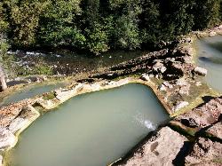
Umpqua Hot Springs
Clearwater, Oregon
2.3 miles NE of Clearwater, OregonNow Open (formerly closed from Sept 2015 to Spring 2016 Due to high E. coli levels)
From Roseburg: Travel east along Highway 138 then turn north onto Road 34, AKA the west entrance to Toketee Ranger Station. At the bottom of the hill turn left across the two concrete bridges. Proceed 2.2 miles and turn right onto Forest Road 3401. Proceed another 0.7 miles to a parking area on the left.
| Fees | $5/vehicle/day OR Northwest Forest Pass |
| Season | All (access road closed during winter = 2 mile snowbound hike in) |
| Type | Roadside/Hike |
| G P S | 43.294 122.367 |
| Map Quad | Toketee Falls 15 or Potter Mountain USGS 7.5 Minute or Umpqua National Forest Map |
| Elevation | 2,600 ft |
| Land | Public – Umpqua National Forest |
| Fee | $5 or Northwest Forest Pass |
| Restrictions | No camping at springs, only allowed in designated areas |
| Usage | High |
| Visibility | Moderate |
| Temp | 108 |
| Water Clarity | Murky |
| Odor | n/a |
| P H | n/a |
| Area Features | North Umpqua River, Central Cascades, Surprise Falls |
| Gas | Roseburg |
| Trash | Heavy |
| Bugs | Moderate |
| Wildlife | Moderate |
| Camping | No on-site, yes nearby |
| Clothing Optional | Yes |
| Pit Toilet | Yes |
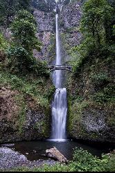
Multnomah Falls
Cascade Locks, Oregon
12.7 miles SW of Cascade Locks, OregonMultnomah Falls is a 620-foot waterfall in Oregon located on the side of the Columbia River Gorge, located east of Troutdale, between Corbett and Dodson, along the Historic Columbia River Highway.


