


8 locations
Add Location
 Full Listing
Show more
Hike, Mountain Bike
Added on 15 Oct 2018
Full Listing
Show more
Hike, Mountain Bike
Added on 15 Oct 2018
0.5 mi
 Full Listing
Show more
Hike, Swim
Added on 15 Oct 2018
Full Listing
Show more
Hike, Swim
Added on 15 Oct 2018
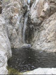
Tanque Verde Falls
Tucson, Arizona
15.4 miles E of Tucson, ArizonaTanque Verde Falls are a set of waterfalls and pools inside of Tanque Verde Canyon near Tucson, Arizona. The canyon is located within Coronado National Forest. There is a parking area on the side of the road, near a trailhead. From there, it's a short hike to the water. An optional trail leads directly to the falls themselves, although this portion is a slightly more difficult climb due to boulders and such along the path. Due to the short hike distance, this is a popular location to cool off.
The best time to go is from September through May, avoiding the summer heat.
This area is considered the "most dangerous" waterfall hike in Arizona, as there have been around 30 deaths since 1971 due to flash flooding and cliff jumping. The area is at high risk for flash floods during monsoon season, and the water level varies, so be very cautious. Pay attention to local weather conditions, stay away from slippery rocks, and don't jump if you're unsure of how deep the pool is.
2.4 mi
 Full Listing
Show more
Hike, Swim
Added on 15 Oct 2018
Full Listing
Show more
Hike, Swim
Added on 15 Oct 2018
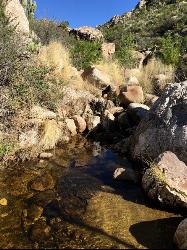
Sycamore Reservoir
Tucson, Arizona
14.3 miles NE of Tucson, ArizonaSycamore Reservoir is a small lake up in Bear Canyon on Mount Lemmon that was originally a water source for an abandoned prison camp. Nowadays, the lake is great for recreation, complete with a sandy shore, a dam, and beautiful trees along the banks. When full, the dam provides a beautiful little waterfall, fed from both Bear and Sabino Canyons. The foilage from the trees are especially striking during the autumn months, although this trail could be hiked any time in the fall, winter, or spring.
The reservoir can be accessed by a lightly trafficked hike through the surrounding Arizona desert. The trail starts off of the old prison camp, which is itself just a short drive from the Catalina Highway. It will lead you down the Arizona Trail from the south end of the parking lot. After two miles, the Molino Basin trail transitions to the Sycamore Reservoir trail at Shreve Saddle (marked with a sign). Along the Sycamore Reservoir trail, a side path to the left will lead you to the dam and reservoir. The main trail will continue until a junction that splits into the East Fork Trail and the Palisades trail.
Make sure to bring plenty of outside water on the hike, as water from the dam is not potable, and requires purification. There are bathrooms at the parking lot, but they may be closed seasonally. There is no running water at the lot.
1.0 mi
 Full Listing
Show more
Hike, Swim
Added on 15 Oct 2018
Full Listing
Show more
Hike, Swim
Added on 15 Oct 2018
Montrose Pool
Tucson, Arizona
14.1 miles N of Tucson, ArizonaMontrose Pool is a seasonal catchment accessable through the Romero Canyon trail in Catalina State Park, Arizona. The pool fills up after rain, but is often dry. The trailhead is the same as is used for the Romero Pools, but is not as long, reaching about a mile on less difficult terrain. Due to heat concerns, this trail is best hiked from October-May.
The trail to Montrose Pool is dog-friendly, however, the trail continues past the pool through a Desert Bighorn Sheep Management Area, where dogs are not allowed. The dog must be on a leash at all times.
As this trail is located within a state park, an entrance fee of $7/vehicle (up to 4 adults) applies.
1.2 mi
 Full Listing
Show more
Hike, Mountain Bike, Rock Climb, Swim
Added on 15 Oct 2018
Full Listing
Show more
Hike, Mountain Bike, Rock Climb, Swim
Added on 15 Oct 2018
La Milagrosa Canyon
Tucson, Arizona
12.6 miles NE of Tucson, ArizonaLa Milagrosa Canyon is a hidden gem just east of Tucson, Arizona and north of the Tanque Verde area. It features many rock-climbing walls, and even a seasonal waterfall with pools for swimming, best accessed by hiking. The waterfall may dry up depending on how long it's been since the last rainfall. Access to the pools will require scrambling over some boulders, especially if you're trying to reach one of the top two pools.
There is little to no sun on this hike, so be sure to take plenty of water and a hat. Like many such destinations in Arizona, this arena is best enjoyed in the fall, winter, or spring to avoid the summer heat. Though it is common to visit the canyon pools shortly after rainfall, take care to watch the local weather conditions to avoid a potential flash flood, which can be deadly.
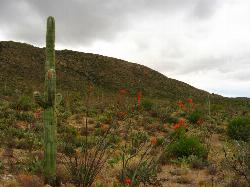
Cactus Forest Trail
Tucson, Arizona
12.1 miles E of Tucson, ArizonaPart of the approximately 10-mile Cactus Forest Trail runs through Saguaro National Park East and provides a nice landscape introduction for newcomers to the desert. A 2.5 mile dirt trail that bisects the Cactus Forest Loop Drive in East Saguaro. The park has designated the Cactus Forest Trail as multi-use and welcomes both horses and bicycles.
This flat, dirst trail is in excellent condition. On both sides, you can see a vast array of cacti, from old giant saguaro to much smaller cholla.The Rincon Mountains loomed to the east, providing a majestic backdrop to the scene.
This easy 2-mile round-trip walk would likely be suitable for children. But simply going along the trail for a short way gives a nice up-close look at what the desert here has to offer. Hiking boots are not needed.
6.2 mi
 Full Listing
Show more
Backpack, Cave, Hike, Rock Climb
Added on 13 Apr 2017
Full Listing
Show more
Backpack, Cave, Hike, Rock Climb
Added on 13 Apr 2017
Darby Wind Cave
Driggs, Idaho
7.6 miles E of Driggs, IdahoDarby Wind Cave is a beautiful hike full of waterfalls, wildflowers, streams, and mountainous views. The sites you see will depend on the time of year you visit but it will always be beautiful and just a little bit of a challenge.
The trail starts out relatively flat, following along close to where the old road used to run. There are a few creek crossings which will vary in difficulty depending on how much snow there was over the winter and how long it's been since things began to thaw. Late summer will usually find you crossing dry or nearly dry creek beds. If you hike when runoff is high, there are log bridges. You don't have to be highwire ready but one of the bridges will take a little bit of balance. The trail turns up South up into the canyon. About as soon as it starts to go up, you'll turn and begin a series of switchbacks (10 turns). These will take you up the East wall of the canyon.
The switchbacks are not incredibly steep but you'll gain elevation pretty quickly. After the switchback, the trail follows along a rim above the canyon where you can look across the canyon and see two beautiful waterfalls and mouth of the cave seemingly high overhead. At the South end of the canyon, you'll come across a rock overhang. It's fun at any time during the summer but earlier when the water is higher, you'll find a little waterfall and stream that the kids will love to play in and you'll be hard pressed not to soak your head and feet and cool off a bit yourself.
From the the overhang, the hike continues West along the South end of the canyon through some more forest and a beautiful meadow. Take a minute to look up from the trail to enjoy the view of Fossil Peak to the South. Just after the meadow, you'll begin another series of switchbacks up to the falls and cave. The first set (2 turns) will take you up to a dispersed campsite and monument. The next leg will take you to the creek where you can look up and get photos of the falls and cave. The next set puts you out just underneath a very large and beautiful waterfall that drops out over a ledge. The ledge itself is a popular repel accessible from above. You can walk all the way around these falls and even catch some spray on the downwind side. The next set of switchbacks are stairs cut out of the rock. Halfway will take you to an even better view of Fossil Peak and the remainder will take you to the mouth of the cave itself. To enter the cave, you'll have to cross one more creek which can be pretty scary and dangerous when the water is high. Entering the cave during high water can be just as scary.
Once you're in, the Wind Cave snakes through the Darby Formation, a thick layer of 350 million year-old dolomite. A flashlight for the cave is a definite must. Near the mouth, there's a series of ledges popular for bouldering. Just up about 100 yards, you'll come to a small hole you'll have to crouch to get through. You'll quickly realize why they're called the wind caves as you're blasted with wind from the caves coming out that hole. After about 200 yards, you'll want your climbing gear. The caves stretch for miles and if you go far enough, you'll enter the part known as the ice caves. Travel far enough, you'll come out the other side. Be careful though. The cave becomes pretty cavelike and it's really easy to get lost and, even in the busy season, it may be days until that nightmare ends with a rescue team.
The hike is about 3.1 miles from the South Fork Darby Canyon trailhead to the caves and is a 1,800 feet elevation gain. You'll find a lot of resources that claim the hike is a shorter distance. These sources either begin from the end of the old road or don't take into account one or both series of switchbacks. The cave itself sits at 8,940 feet above sea level.
3.8-6.4 mi
 Full Listing
Show more
Camp, Hike
Added on 13 Apr 2017
Full Listing
Show more
Camp, Hike
Added on 13 Apr 2017
Table Rock / Table Mountain
Driggs, Idaho
10.0 miles E of Driggs, IdahoAt roughly 11,100 feet, the flat-topped summit of Table Mountain serves up what many consider the single finest view of the Grand Teton anywhere — and one of the great day hikes on the quiet, western (Idaho) side of the range. From the broad mesa top you stand just far enough back to take in all three Teton peaks at once, yet close enough to pick out the detail on the Grand's sheer east face across the deep gulf of the canyon. It's a jaw-dropping payoff, and a hard-earned one.
The mountain holds a remarkable place in history. In 1872, pioneering survey photographer William Henry Jackson hauled his heavy glass-plate camera gear by mule to the top of Table Mountain and made the first photographs ever taken of the Grand Teton — images that helped introduce the range to the wider world and build support for protecting it. Jackson chose this peak precisely because its gentle western slopes could be reached without technical climbing, and that's still what makes the summit attainable for strong day hikers today.
The trailhead sits at the end of Teton Canyon Road outside Driggs and Alta, and nearly the entire route lies within the Jedediah Smith Wilderness of the Caribou-Targhee National Forest. There are two main ways up, and both climb over 4,000 feet. The Face Trail is the steeper, shorter option (about 3.5 miles one way), skipping the switchbacks to head more or less straight up. The Huckleberry (North Fork) Trail is longer but far more gradual (about 6.5 miles one way), following and crossing the North Fork of Teton Creek — handy spots to filter water — through meadows and, in mid-to-late summer, ripe huckleberries for those who beat the crowds to the bushes. Many hikers link the two into a big loop of roughly 11–13 miles, and tough-but-knee-conscious hikers generally prefer to climb up the steep Face and come down the gentler Huckleberry, sparing their knees the pounding of a steep descent. The lower trail is a delight in its own right, tracing rushing Teton Creek past a string of waterfalls.
The wildflowers here are spectacular. As the snow recedes, Table Mountain's meadows erupt in color — sweeping displays of lupine, arrowleaf balsamroot, and Indian paintbrush, with columbine in the shadier pockets and delicate alpine blooms up high. In the Tetons the canyon meadows tend to peak from early-to-mid July, while the highest ground saves its show for late July into August; even when snow still blocks the upper trail, the lower meadows near the trailhead put on an easy, photogenic display. It's one of the finest wildflower hikes in the region.
This is high, exposed country, so plan accordingly. At over 11,000 feet the air is thin and the weather changes fast: afternoon thunderstorms build quickly over the peaks in summer, so start early and aim to be off the open summit by early afternoon. Table Mountain is enjoyed year-round — it's a popular snowshoe and backcountry-ski destination in the snowy months. If you're after dry summer hiking, though, know that you're likely to encounter snow on the upper mountain before mid-July: early-season snowfields often begin around 9,500 feet with larger patches up high, and the Huckleberry side can hold avalanche debris and downed trees until it melts out. It's frequently still passable with the right footwear — just come expecting it. Conditions are typically most reliably snow-free from about mid-July through September. It's also easy to lose the trail, especially on the descent, so pay attention to your route and carry a map or GPS. Keep an eye out for wildlife, too — moose are a common sight in the canyon, and the area is home to the occasional mountain lion.
Bring layers, sun protection, plenty of water (and a filter), and sturdy footwear for the long, steep grade. You can check current conditions on the webcams at tetoncam.com before you drive up. Backpackers sometimes camp in the meadows below the summit to catch the Grand at sunrise — an unforgettable sight — while following Leave No Trace and wilderness regulations. However you do it, Table Mountain earns its reputation: a leg-burning climb to a mesa in the sky, carpeted in wildflowers, with the Grand Teton filling the horizon just as it did for Jackson a century and a half ago.
0.8 mi
 Full Listing
Show more
Hike
Added on 13 Apr 2017
Full Listing
Show more
Hike
Added on 13 Apr 2017
Conant Creek Pegram Truss Railroad Bridge
Ashton, Idaho
5.0 miles SE of Ashton, IdahoAs part of the Rails to Trails project, this old railroad bridge has been transformed into a very safe little viewing experience for the whole family. You can drive right up to the bridge where there is a great little spot to park. Conant Creek meeanders hundreds of feet below the bridge. It's about 300 yards across and whether you're taking in the vibrant colors of spring, the beautiful fall colors, or the Tetons looming in the background, the view is spectacular.
The bridge is part of the 30 mile Ashton-Tetonia Trail. There is a smaller bridge less than 2.5 miles north on the trail.
×


