


Darby Wind Cave
Driggs, Idaho

| Address: | Darby Canyon Rd, Alta, WY 83414, USA |
| GPS: |
43°41'11.1"N 110°58'8.2"W Maps | Directions |
| State: | Wyoming |
| Trail Length: | 6.20 miles |
| Trail Type: | Out & Back |
| Hike Difficulty: | Intermediate |
| Elevation Gain: | 1898 feet |
| Trails/Routes: | 6.2 mi |
Waterfalls Streams Wildflowers Paintball Permitted Pet Friendly Restrooms Bicycles Motorized Use
Backpack, Cave, Hike, and Rock Climb
Darby Wind Cave is a beautiful hike full of waterfalls, wildflowers, streams, and mountainous views. The sites you see will depend on the time of year you visit but it will always be beautiful and just a little bit of a challenge.
The trail starts out relatively flat, following along close to where the old road used to run. There are a few creek crossings which will vary in difficulty depending on how much snow there was over the winter and how long it's been since things began to thaw. Late summer will usually find you crossing dry or nearly dry creek beds. If you hike when runoff is high, there are log bridges. You don't have to be highwire ready but one of the bridges will take a little bit of balance. The trail turns up South up into the canyon. About as soon as it starts to go up, you'll turn and begin a series of switchbacks (10 turns). These will take you up the East wall of the canyon.
The switchbacks are not incredibly steep but you'll gain elevation pretty quickly. After the switchback, the trail follows along a rim above the canyon where you can look across the canyon and see two beautiful waterfalls and mouth of the cave seemingly high overhead. At the South end of the canyon, you'll come across a rock overhang. It's fun at any time during the summer but earlier when the water is higher, you'll find a little waterfall and stream that the kids will love to play in and you'll be hard pressed not to soak your head and feet and cool off a bit yourself.
From the the overhang, the hike continues West along the South end of the canyon through some more forest and a beautiful meadow. Take a minute to look up from the trail to enjoy the view of Fossil Peak to the South. Just after the meadow, you'll begin another series of switchbacks up to the falls and cave. The first set (2 turns) will take you up to a dispersed campsite and monument. The next leg will take you to the creek where you can look up and get photos of the falls and cave. The next set puts you out just underneath a very large and beautiful waterfall that drops out over a ledge. The ledge itself is a popular repel accessible from above. You can walk all the way around these falls and even catch some spray on the downwind side. The next set of switchbacks are stairs cut out of the rock. Halfway will take you to an even better view of Fossil Peak and the remainder will take you to the mouth of the cave itself. To enter the cave, you'll have to cross one more creek which can be pretty scary and dangerous when the water is high. Entering the cave during high water can be just as scary.
Once you're in, the Wind Cave snakes through the Darby Formation, a thick layer of 350 million year-old dolomite. A flashlight for the cave is a definite must. Near the mouth, there's a series of ledges popular for bouldering. Just up about 100 yards, you'll come to a small hole you'll have to crouch to get through. You'll quickly realize why they're called the wind caves as you're blasted with wind from the caves coming out that hole. After about 200 yards, you'll want your climbing gear. The caves stretch for miles and if you go far enough, you'll enter the part known as the ice caves. Travel far enough, you'll come out the other side. Be careful though. The cave becomes pretty cavelike and it's really easy to get lost and, even in the busy season, it may be days until that nightmare ends with a rescue team.
The hike is about 3.1 miles from the South Fork Darby Canyon trailhead to the caves and is a 1,800 feet elevation gain. You'll find a lot of resources that claim the hike is a shorter distance. These sources either begin from the end of the old road or don't take into account one or both series of switchbacks. The cave itself sits at 8,940 feet above sea level.
More Information
How I Spent My Summer, 2012 Part V: Travelogue, Darby Canyon and the Wind Cave
Rhys and me at the Wind Cave My son Rhys spent a week up at Treasure Mountain Boy Scout Camp. Last year, when he was there, we hiked T…
http://bascombemania.blogspot.com/2012/08/how-i-spent-my-summer-2012-part-v.htmlBe courteous, informed, and prepared. Read trailhead guidelines, stay on the trail, and don't feed the wildlife.
Read More- Plan Ahead and Prepare
- Travel & camp on durable surfaces
- Dispose of waste properly
- Leave what you find
- Minimize campfire impacts
- Respect wildlife
- Be considerate of other visitors
Directions
From Driggs, Idaho
- Head south on ID-33 E/
N Main St toward E Little Ave Continue to follow ID-33 E(3.0 mi) - Turn left onto W 3000 SEntering Wyoming(3.2 mi)
- Turn right onto S Stateline Rd (0.1 mi)
- Continue onto Darby Canyon RdDestination will be on the left(4.2 mi)
The trailhead is located about 20 minutes outside the town of Driggs. It is very easy to miss Darby Road turnoff from Highway 33, three miles south of Driggs ID; the turn off is just south of the Spud Theater. Drive several miles up the canyon till you see the trailhead.
jamadeus
5/26/17 5:48 pmleahmia
4/13/17 4:03 pm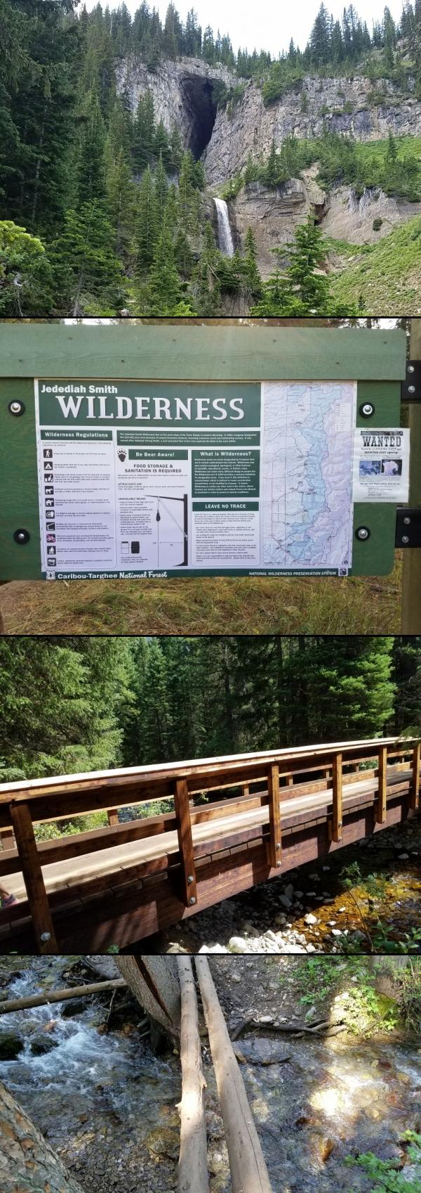 Darby Wind Caves courtesy of endovereric↗


 Information courtesy of endovereric↗
 Darby Creek Bridge courtesy of endovereric↗
 Last crossing before switchbacks (high water) courtesy of endovereric↗
 courtesy of endovereric↗") Looking up the Canyon courtesy of endovereric↗
Looking up the Canyon courtesy of endovereric↗
 Darby Creek Falls - Dry (low water) courtesy of endovereric↗
 courtesy of endovereric↗") Darby Creek Falls (high water) courtesy of endovereric↗
Darby Creek Falls (high water) courtesy of endovereric↗
 courtesy of endovereric↗") Wildflower Meadow courtesy of endovereric↗
Wildflower Meadow courtesy of endovereric↗
 Lower falls (low water) courtesy of endovereric↗
 courtesy of endovereric↗") Falls below the caves (high water) courtesy of endovereric↗
Falls below the caves (high water) courtesy of endovereric↗
 courtesy of endovereric↗") Cave And Falls From South Ledge courtesy of endovereric↗
Cave And Falls From South Ledge courtesy of endovereric↗
 Mouth of cave (high water) courtesy of endovereric↗
 courtesy of endovereric↗") Cave Entrance (low water) added by endovereric
Cave Entrance (low water) added by endovereric
 added by endovereric") The Birth Canal courtesy of endovereric↗
The Birth Canal courtesy of endovereric↗
 Cave and upper falls (low water) courtesy of endovereric↗
 courtesy of endovereric↗") Looking out of the cave courtesy of endovereric↗
Looking out of the cave courtesy of endovereric↗
 Looking out from the mouth of the cave courtesy of endovereric↗


Other Rock Climbing Walls, Hiking Trails, Caves, and Backpacking Trails Nearby
Darby Canyon Cliffs
Alta, Wyoming
2.8 miles WA popular west-slope hike near Alta, Wyoming to an ancient Wind Cave snaking through 350-million-year-old dolomite, with waterfalls and wildflowers cascading down the canyon rim along the way.
Rock Climb 4.5 mi
Aspen Trail
Alta, Wyoming
4.1 miles NWFlowing singletrack along a 6,800-ft ridgeline contour connects to Darby Canyon on a mix of smooth and rocky terrain — a satisfying intermediate out-and-back or loop.
Hike, Mountain Bike 4.5 mi
Sheep Bridge Trail
Driggs, Idaho
5.2 miles NAn easy 2.25-mile trail through summer wildflowers and kaleidoscopes of butterflies along Teton Creek — cross a bridge, meander east, and dip down to the creek at a midway rest spot.
Hike, Mountain Bike 7.9 mi
Devil's Stairs
Driggs, Idaho
5.5 miles NEAn 8-mile round-trip trail that starts from the Teton Canyon Trailhead, climbs 1,000 feet in switchbacks, and arrives at a stunning high meadow filled with wildflowers and framed by a towering cliff.
Backpack, Hike 15.0-18.4 mi
Alaska Basin
Driggs, Idaho
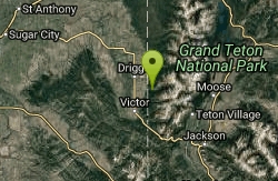
5.5 miles NEA stunning trail through the Jedediah Wilderness into Wyoming near Grand Teton National Park, with wildflowers, rushing rivers, the Teton Range, and the serene Alaska Basin — intermediate to advanced.
Backpack, Hike, Horseback 3.8-6.4 mi
Table Rock / Table Mountain
Driggs, Idaho
5.5 miles NEA big climb to 11,300 feet for arguably the finest view of the Grand Tetons — pick the steep Face or the gradual Huckleberry trail.
Camp, Hike 4.9 mi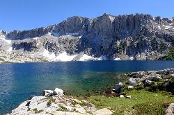
Amphitheater Lake
Alta, Wyoming
9.8 miles EAmphitheater Lake is one of Grand Teton National Park's most rewarding alpine destinations — a sparkling cirque lake cradled in granite high above the treeline, beneath the soaring peaks of...
Backpack, Hike 1.3-4.3 mi
Phelps Lake
Jackson, Wyoming
10.6 miles SEA 5.5-mile loop around beautiful Phelps Lake with mountain scenery, majestic blue water, several Teton waterfalls, and lakeside campsites — plus a popular cliff jumping rock along the trail.
Backpack, Camp, Dive, Hike, Swim
Jumping Rock at Phelp's Lake
Jackson, Wyoming
10.6 miles SEA solo 20-foot boulder perched above deep water at Phelps Lake, with Death Canyon looming overhead — one of the most dramatic jump spots in all of Wyoming.
Dive, Hike, Swim 3.9-14.4 mi
Grand Teton
Jackson Hole, Wyoming
11.8 miles EAt 13,770 feet, the Grand Teton towers over Western Wyoming — all popular routes require rock climbing gear and are for skilled climbers only, with 3,000 feet of exposure where a fall is fatal.
Backpack, Hike, Rock Climb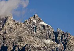
Mount Owen
Jackson, Wyoming
11.8 miles EMount Owen is the second-highest peak in the Teton Range, a striking 12,928-foot summit rising in the heart of Grand Teton National Park, Wyoming, just north of its famous neighbor, the Grand Teton....
Hike 13.8 mi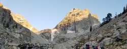
Middle Teton
Jackson Hole, Wyoming
11.8 miles EThe 12,804-ft Middle Teton rewards serious alpinists with glacier bouldering through the Southwest Couloir and panoramic views of the Grand, South, and surrounding Tetons.
Backpack, Hike, Rock Climb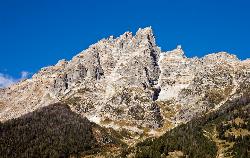
Teewinot Mountain
Jackson Hole, Wyoming
11.9 miles ETeewinot Mountain is a 12,325-ft Teton spire above Jenny Lake — the range's deadliest peak and a committing 4th-class East Face climb, not a hike.
Backpack, Hike 1.0-5.1 mi
Jenny Lake Trail
Jackson Hole, Wyoming
12.2 miles NEAn easy loop around Jenny Lake in Grand Teton National Park — visiting Hidden Falls, Inspiration Point, and abundant wildlife including marmots, moose, and occasional bears along the well-built stone-stair trail.
Hike 4.6 mi
Coal Creek Trail
Alta, Wyoming
12.2 miles SA hike beyond Coal Creek Meadows to a mountain divide with dramatic views of the Mesquite Creek Valley and the peaks to the north, including Grand Teton on the horizon.
Hike, Mountain Bike 24.3 mi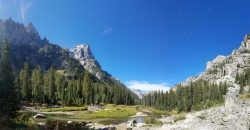
Cascade Canyon Trail
Jackson Hole, Wyoming
13.1 miles EA wildlife-rich canyon hike past Hidden Falls and into Cascade Canyon, where waterfalls pour off glacier-fed mountains flanking the Grand Teton.
Backpack, Hike 3.6 mi
String Lake
Alta, Wyoming
13.7 miles NEA shallow, warm lake connecting Jenny and Leigh Lakes at the base of the Tetons — the clear water lets you see the bottom from a kayak, wade easily with kids, and access wilder open water beyond.
Canoe, Hike, Kayak, Swim 0.1-7.3 mi
Leigh Lake
Alta, Wyoming
13.8 miles NETucked beneath Mount Moran and just a mile from the String Lake trailhead, Leigh Lake rewards with majestic serenity, shoreline views of Boulder Island, and calm waters perfect for kayaking or canoeing.
Backpack, Canoe, Hike, Kayak 10.5-16.2 mi
Paintbrush Canyon
Alta, Wyoming
13.8 miles NEA beautiful trail along String Lake, Leigh Lake, and Lake Solitude in Grand Teton — with a short, rewarding scramble to the secluded Micah Lake perch for even fewer crowds.
Backpack, Hike
Mt. Moran
Alta, Wyoming
14.1 miles NEAt 12,610 feet, this dominant Teton peak rises 6,000 feet above Jackson Lake, with the Skillet Glacier plainly visible on its massive east face.
Hike
Nearby Campsites

Darby Canyon Camping
Alta, Wyoming
2.7 miles WDispersed campsites with fire lays in scenic Darby Canyon — no official campground, just established spots in Wyoming wilderness. Leave No Trace and use existing rings only.
Camp
Reunion Flat Campground
Alta, Wyoming
5.0 miles NCamp near Alta, Wyoming
Camp
Teton Canyon Campground
Alta, Wyoming
5.4 miles NETeton Canyon Campground is the gateway to Alaska Basin, Table Rock, and the Teton Crest Trail — each site stocked with a picnic table, fire ring, and bear box.
Camp 3.8-6.4 mi
Table Rock / Table Mountain
Driggs, Idaho
5.5 miles NEA big climb to 11,300 feet for arguably the finest view of the Grand Tetons — pick the steep Face or the gradual Huckleberry trail.
Camp, Hike
Mike Harris Campground
Victor, Idaho
10.3 miles SWA scenic mountain campground at 6,200 feet along Teton Pass just 5 miles from Victor, Idaho — a peaceful base for fishing, trail exploring, and sightseeing in the Teton region.
Camp 1.3-4.3 mi
Phelps Lake
Jackson, Wyoming
10.6 miles SEA 5.5-mile loop around beautiful Phelps Lake with mountain scenery, majestic blue water, several Teton waterfalls, and lakeside campsites — plus a popular cliff jumping rock along the trail.
Backpack, Camp, Dive, Hike, Swim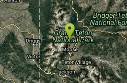
Jenny Lake Campground
Jackson Hole, WY
13.1 miles ETucked right at the base of the Tetons, this tent-only campground fills before 8 AM in summer for good reason — alpine beauty, quiet sites, and unbeatable Teton proximity.
Camp
Pine Creek Campground
Victor, Idaho
14.2 miles SWThe Pine Creek Campground has 10 single units and has restrooms.
Camp 2.8-4.1 mi
Palisades Creek Trail / Lakes and Waterfall Canyon
Irwin, Idaho
23.4 miles SWSpectacular mountain views, two landslide-formed alpine lakes, and mountain goat sightings — all within a 4-to-6-mile hike in the Swan Valley wilderness.
Backpack, Camp, Hike, Horseback, Mountain Bike
Moody Meadows
Driggs, Idaho
24.8 miles WGood place for kids, they can ride bikes in the meadow, play in the stream, and camping is off of the road. Hiking, motorbiking, and horseback riding trails are abundant in the area.
Camp
Big Elk Campground
Irwin, Idaho
26.2 miles SA versatile campground near Palisade Reservoir with fishing, hiking, horseback riding, and kayaking — plus a small secluded lake on the drive in that's perfect for a quiet afternoon.
Camp 6.9 mi
Big Elk Creek
Irwin, Idaho
26.2 miles SA versatile campground on a small dammed lake with fishing, kayaking, hiking and backpacking into the Caribou-Targhee National Forest, and stunning fall Aspen and Douglas-Fir colors on the Big Elk Creek Trail.
Backpack, Camp, Canoe, Hike, Horseback, Kayak
Falls Campground
Victor, Idaho
26.4 miles SWA Snake River campground near Swan Valley with cottonwood shade, abundant wildlife — eagles, osprey, moose, and deer — and Fall Creek Falls just a quarter mile away; Palisades Reservoir is 20 miles out.
Camp
Fall Creek Falls
Swan Valley, Idaho
26.6 miles SWA shaded Snake River campground near Swan Valley with abundant wildlife, great trout fishing, and Fall Creek Falls a quarter-mile away.
Camp, Cave, Hike, Kayak, Swim
Crystal Creek Campground
Jackson, Wyoming
27.4 miles EA small, peaceful campground along two Wild and Scenic Rivers — the Gros Ventre and Crystal Creek — with nearby options for hiking, biking, and OHV riding.
Camp
Calamity Campground
Irwin, Idaho
27.7 miles SWA wooded Palisades Reservoir campground 55 miles east of Idaho Falls with clean blue water for swimming, boating, water skiing, and fishing — plus miles of ATV routes.
Camp, Canoe, Hike, Kayak, Mountain Bike, Swim
Sheep Falls on Fall River
Ashton, Idaho
27.9 miles NA local gem off Cave Falls Road where the river splits into multiple falls tumbling over each other — primitive campsites and beautiful views make it a great picnic stop.
Camp
Loon Lake
Ashton, Idaho
29.5 miles NCamp, Kayak, and Swim near Ashton, Idaho
Camp, Kayak, Swim
Indian Creek Campground (Palisades)
Irwin, Idaho
29.9 miles SA picturesque reservoir nestled between the Snake River and Caribou ranges, just 25 miles from Jackson Hole — a beautiful drive and a wildlife-rich fishing base.
Camp, Hike, Horseback, Swim
Porcupine Creek
Ashton, Idaho
30.4 miles NWA backcountry hunting, fishing, camping, and swimming spot in Targhee National Forest, surrounded by forests, meadows, a creek, and unmarked trails — bear country, so pack and store food carefully.
Camp, Swim


