


Refine Search
- hike 6
- mountain bike 6
- sled 3
- swim 2
- disc golf 2
- horseback 2
- camp 2
- cave 1
- cross-country ski 1
- backpack 1
- kayak 1
- canoe 1
13 locations
Add Location

 Full Listing
Cave
Last visited on 23 May 2018
Full Listing
Cave
Last visited on 23 May 2018
 Full Listing
Disc Golf
Last visited on 5 May 2018
Full Listing
Disc Golf
Last visited on 5 May 2018
 Full Listing
Backpack, Camp, Hike, Horseback, Mountain Bike
Last visited on 16 Aug 2017
Full Listing
Backpack, Camp, Hike, Horseback, Mountain Bike
Last visited on 16 Aug 2017
 Full Listing
Sled
Last visited on 16 Mar 2017
Full Listing
Sled
Last visited on 16 Mar 2017
 Full Listing
Sled
Last visited on 21 Sep 2015
Full Listing
Sled
Last visited on 21 Sep 2015
 Full Listing
Cross-country Ski, Hike, Mountain Bike
Last visited on 17 Jul 2015
Full Listing
Cross-country Ski, Hike, Mountain Bike
Last visited on 17 Jul 2015
 Full Listing
Sled
Last visited on 30 Aug 2014
Full Listing
Sled
Last visited on 30 Aug 2014
0.1-0.3 mi
Full Listing
Disc Golf
Last visited on 6 Jul 2018
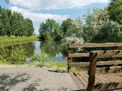
Rexburg Nature Park
Rexburg, Idaho
0.8 miles NW of Rexburg, IdahoRexburg Nature Park:
Life can be stressful, annoying, or just not good. Sometimes, it takes a moment to simply get away from the non-sense of this world; to gather yourself and seek peace and tranquility. That option is around the corner; you drive and see a trail, so you park and walk on the trail. As you walk, there's trees and sunlight shining on the leaves. You walk further and see a pond with ducks (both green and brown) and families sitting on the green grass with their kids; they watch, feed the ducks and take pictures with a smile on their face.
You go back to your vehicle and reminisce what you saw. Close to the south fork of the Teton River, is a nature park that isn't crowded with college students or infested with incoming traffic but a 15 acre park that was made so you can take your family or acquaintances for a picnic or a social gathering and enjoy; you also have the option to ride your bike or to jog on the trails.
The park is next to the Claire Boyle skate park, a beautiful golf course next to the fairgrounds and a 9 hole Frisbee golf course.
Features:
-Playground for the kids
-Fishing ponds ( A valid fishing license is required); fishing ponds for children as well.
-Wildlife and wildflowers
For more information and questions:
| Phone | 208-359-3020 Ext. 0 |
|
customerservices@rexburg.org |
Monkey Rock
Saint Anthony, Idaho
4.1 miles SE of Saint Anthony, IdahoCLOSED. PSA: Monkey Rock is no longer open to the public. The owner has posted "No Trespassing" signs and is asking the Fremont County Sheriff's Office to assist with keeping people out of their private property. We would like to remind those who may choose to ignore the "No Trespassing" signs that trespassing is a misdemeanor and will not be tolerated.
Full Listing
Swim
Last visited on 14 Jun 2018
Monkey Rock features a beautiful waterfall you can wade right up to during the summer. Just under the waterfall is a great spot to wade around in or even some shallow swimming pretty good for small children. Maybe you just want to take advantage of the great bank to bask in the summer sun. The water temperature is fairly cool, which by no means is unwelcomed during the hot summer months. You'll get used to the water fairly quickly once you're in. The waterfall is a fun feature at Monkey Rock, not to mention a popular engagement photo backdrop. The name "Monkey Rock" is derived from the "monkeys" who jump off the rocks at the top of the falls to the pool below. Though not a great height, it's important to be careful and only jump into areas clear of rocks and other hazards and where the water is deep enough that you won't hit bottom when you jump. There really isn't a safe spot to jump from the falls as it doesn't usually get more than 5 feet deep.
The real jumping location is off the Hog Hollow Bridge up the road from the waterfall.
PLEASE NOTE: On the roads leading to Monkey Rock, the speed limit is 35 mph for the last mile. There are kids, cows, horses, and dogs along that road and many people tend to speed going to and from Monkey Rock. Please slow down and stay safe.
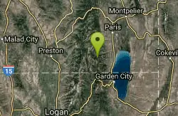
Minnetonka Cave
Saint Charles, Idaho
6.9 miles W of Saint Charles, IdahoMinnetonka Cave is the largest commercially developed limestone rock cave in the state of Idaho, and one of the highest, with an entrance elevation of 7,700 feet. The developed part of the cave contains nine separate "rooms" or chambers. The largest of these chambers is called the Ballroom, measuring more than 300 feet across and 90 feet high.
1.8 mi
 Full Listing
Hike, Mountain Bike
Last visited on 16 May 2018
Full Listing
Hike, Mountain Bike
Last visited on 16 May 2018
Gailey Trail At Nicholls Park (Nicholls Hollow)
Kaysville, Utah
1.1 miles SE of Kaysville, UtahThe shady Gailey Trail at Nicholls Park (also known as Bair Creek or Nicholls Hollow) is perfect for walking, running, and enjoying the fresh air of nature all four seasons of the year. The nature trail has a nice tree cover overhead to keep you cool in the summer and is mostly dirt and bark. The trails trees leaves are incredible to admire in the autumn and transform into a magnificently snowy wonderland in the winter months as the white treetops are covered. While dogs are allowed along the trail, they must be on a leash. Trail map boards and benches are located along the way. There are small bridges to walk over streams throughout the trail. The trail is not difficult but there are multiple entrances to the Gailey trail and some are easier access than others. The parking lot closest to Main Street in Kaysville provides the least steep hill to access the trail whereas the entrance near the Nicholls playground and pavilions is quite steep. The trail is located below Castle Park of Fruit Heights City, known for its bright red castle tops, bark, swings and large grassy areas with a spectacular view of the mountains.
David Applied Technology College Disc Golf
Kaysville, Utah
0.8 miles SE of Kaysville, UtahA fun park course with elevation changes. There are a lot of longer open holes and some shorter more technical ones around obstacles and trees. Nicely designed for the terrain and available space. Public (No Fee)Courtesy of DiscGolfUnited.com
6.4 mi
 Full Listing
Hike, Mountain Bike
Last visited on 10 Mar 2018
Full Listing
Hike, Mountain Bike
Last visited on 10 Mar 2018
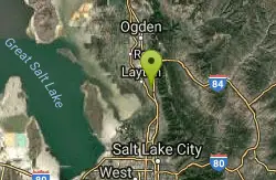
Farmington Canyon
Farmington, Utah
0.9 miles N of Farmington, UtahFarmington Canyon is a gorgeous location to explore during all four seasons of the year, but the prime months for visiting are April through October. The dusty Skyline Drive long is along a gravel road and very bumpy to drive up. It is closed for cars during the winter months. The road connects Farmington to Bountiful thus providing access to Francis Peak, Bountiful Peak as well as the Smith Lakes.
The colors of the leaves within the canyon are incredibly vibrant throughout the year, especially in autumn. Farmington Canyon is a great place to take a bumpy yet beautiful car ride, to go camping, trail running or enjoy a scenic walk. The Farmington Creek Trail includes rocks to climb over as well as stream crossings and does not have much shade covering. Farmington Canyon provides an incredible view of Kaysville and the Great Salt Lake.
The Sunset campground, composed of 16 sites, is located on the Farmington side, 3.6 miles from the pavement is on the ridge of the canyon. Located further up the canyon is the Bountiful Peak campground which has 21 sites. Located at the bottom of the canyon is Farmington Pond which is another place to visit and includes picnic tables and a paved trail.
6.2-16.2 mi
 Full Listing
Hike, Horseback, Mountain Bike
Last visited on 17 Aug 2017
Full Listing
Hike, Horseback, Mountain Bike
Last visited on 17 Aug 2017
Antelope Island
Syracuse, Utah
9.3 miles W of Syracuse, UtahAntelope Island State Park, the largest island in the Great Salt Lake, is home to a roaming herd of 500 bison. Pronghorn and bighorn sheep also share the rangelands that overlook the desert lake. Opportunities to view wildlife are available on backcountry trails, which are open to horseback riding, mountain biking, hiking and cross-country skiing. Please keep in mind that pets on leash are allowed on the island except on the Frary Peak trail. A visitor center offers information on the island's unique biology, geology and history. Please be aware that, during the month of May and part of June (usually until the weather reaches 90 degrees), Antelope Island has biting gnats (or "no see'ums"). Wear a hat or light hoodie and protect your face and neck with bugspray. Insects on the causeway are midges that don't bite, and brine flies along the lake's edge are harmless. Courtesy of AllTrails.com
Antelope Island is located on the east side of Utah's Great Salt Lake. Trails include:
- Lakeside Trail
- White Rock Loop
- Split Rock Bay Loop
- Elephant Head
- East Side Trail
The best times of year for biking Antelope Island are early spring an late fall. Beware of the bug situation in late spring and early summer. Bug spray is mandatory.
Antelope Island offers nearly 20 miles of trails open to hikers, horseback riders, and mountain bikers, and more trails are being crafted yearly. The 2-mile Lakeshore Trail is well suited for novice riders or for families with children. Start at the White Rock Bay campground and pedal around the base of Buffalo Point along the shore of the Great Salt Lake. Turnaround where conditions get too rocky and watch the sun set from a trail-side rest bench.Courtesy of utah.com
There is some interesting singletrack out here, but you've got to fight your way through a lot of boring doubletrack to get there. Their scenery is nothing special as the Great Salt Lake isn't that pretty (not to mention the smell). This ride's most redeeming feature is that it dries out before the Wasatch, so you can get some training in before the real trails open up. Courtesy of Singletracks.com
Antelope Island State Park
Syracuse, Utah
10.0 miles SW of Syracuse, UtahLocated just 41 miles north of Salt Lake City, Antelope Island State Park encompasses a vast selection of outdoor activities and spectacular scenery providing a peaceful nature experience. Experience stunning 360-degree views as you drive around the State Park or try other activities such as exploring the roughly 20 miles of trails open for hiking, biking, and running or horseback riding. Picnic tables and designated campsites are available though RV hookups are not provided.
Enjoy the water as you kayak, fish, sail, or swim off of the Great Salt Lake’s largest island. Wild animals such as antelope, birds, bison, bobcats, coyotes, deer, and horned sheep roam freely and claim Antelope Island home. Watching the wildlife is a must. Be sure to take caution around wildlife and keep your distance. Do not touch or feed wildlife.
Absorb the beauty of nature through spectacular sunrises, sunsets, and the spectacular night sky. The Visitor Center includes publications, restrooms, and exhibits for all to enjoy. The best times of year for exploring Antelope Island are early spring an late fall. Beware of the bug situation in late spring and early summer. Bug spray is mandatory. Don't forget to bring drinking water as well to stay hydrated during your adventures.
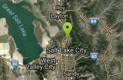
Bountiful City Park
Bountiful, Utah
2.1 miles W of Bountiful, Utah- Length: ~100-200ft
- Slope: ~45°
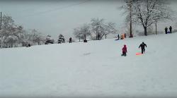
St. Anthony Sand Dunes
Saint Anthony, Idaho
6.0 miles NW of Saint Anthony, IdahoBest known for their offroad riding conditions, the St. Anthony Sand Dunes provide a sledding experience unlike any other. These mountains of sand are fun for sliding down in the summer but during the winter, you won't find a smoother surface for the snow. There are hills everywhere you look and it doesn't take much to find a bowl or halfpipe like experience.
Mueller Park Trail
Bountiful, Utah
2.9 miles SE of Bountiful, UtahThe Mueller Park Trail is a great year-round trail that's almost right off the road. It's considered moderate difficulty. It's a gradual grade with beautiful views. It's a popular trail in the summer so be prepared to move over for other bikers and hikers. The trail is generally wide enough for both.
Length:
- 13 mile round trip
- 3.6 mile to Elephant Rock
This is a very popular out-and-back ride, for good reason. It's full of smooth buff singletrack out of the city, with fast, flowy turns coming back down. It's steady, light-to-moderate climbing the whole way up to Rudy's Flat, with some minor technical sections in the upper half. Courtesy of MTBProject.com
This is a great little up and back route. You'll climb just shy of 2,000 feet over 6.5 miles, but it seems like less. You'll know you've reached the top when the trail levels out in a clearing. If you want to do a loop, you can continue on. The trail will drop more steeply than going back the way you came. However, there will be a few miles of road back to where you started. If you turn around, you reap the reward of the fast, flowy downhill back to your car. It's best to do this at an off-peak time as this is a popular trail and you may not want to interrupt that very fun downhill by all the necessary yelds to uphill riders. If you want to get most There is lots of vegetation along the way and the trees throw lots of color in the fall. Courtesy of Singletracks.com
Sugar House Park
Salt Lake City, Utah
3.2 miles SE of Salt Lake City, UtahThere are a few shorter slopes around the park which are great for sledding and one big hill in the Southwest corner that will get you some real speed.
2.9 mi
 Full Listing
Camp, Canoe, Hike, Kayak, Mountain Bike, Swim
Last visited on 10 Jul 2014
Full Listing
Camp, Canoe, Hike, Kayak, Mountain Bike, Swim
Last visited on 10 Jul 2014
Pineview Reservoir
Eden, Utah
0.8 miles SW of Eden, UtahLocated on the backside of the Wasatch Front, Pineview Reservoir in the Ogden River Canyon is home to stunning views of the water, sandy beaches, the Southern Skyline trail, paved ramps, and campgrounds thus providing a great location for recreational activities of many kinds. Popular activities include boating, canoeing, fishing, horseshoe, kayaking, paddle boarding, picnicking, swimming, volleyball, wakeboarding, and water skiing.
The reservoir is a vastly popular location for fishing tiger muskie and is great for experiencing the picturesque beauty of nature. The three swimming areas are Cemetery Point (west of Huntsville), Anderson Cove campground, and Middle Inlet Beach (north of Huntsville). Shade is scarce so be sure to bring your own canopy or cover during hot summer months as well as wear sun protection. The beaches tend to be busy on weekends.
The out-and-back Southern Skyline trail totals 18.2 miles in distance and is located between the highway and reservoir perfect for walking, biking, and riding dirt bikes. The trail initially commences with a slight uphill climb which increases as the trail progresses. Be cautious and courteous to wildlife including snakes. The campground gates are locked each night at 10 p.m. and are reserved on a first come, first served basis.
×


