


Rexburg Nature Park
Rexburg, Idaho
| Address: | 525 N 5th W, Rexburg, ID 83440, USA |
| GPS: |
43°49'58.8"N 111°48'1.2"W Maps | Directions |
| State: | Idaho |
| Trails/Routes: | 0.1-0.3 mi |
Restrooms Picnic Tables Fall Colors
Disc Golf
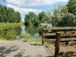
Rexburg Nature Park:
Life can be stressful, annoying, or just not good. Sometimes, it takes a moment to simply get away from the non-sense of this world; to gather yourself and seek peace and tranquility. That option is around the corner; you drive and see a trail, so you park and walk on the trail. As you walk, there's trees and sunlight shining on the leaves. You walk further and see a pond with ducks (both green and brown) and families sitting on the green grass with their kids; they watch, feed the ducks and take pictures with a smile on their face.
You go back to your vehicle and reminisce what you saw. Close to the south fork of the Teton River, is a nature park that isn't crowded with college students or infested with incoming traffic but a 15 acre park that was made so you can take your family or acquaintances for a picnic or a social gathering and enjoy; you also have the option to ride your bike or to jog on the trails.
The park is next to the Claire Boyle skate park, a beautiful golf course next to the fairgrounds and a 9 hole Frisbee golf course.
Features:
-Playground for the kids
-Fishing ponds ( A valid fishing license is required); fishing ponds for children as well.
-Wildlife and wildflowers
For more information and questions:
| Phone | 208-359-3020 Ext. 0 |
|
customerservices@rexburg.org |
More Information
Nature Park - Rexburg Online
Nature Park is unique in that it is away from traffic and in a more tranquil environment and in a beautiful area close to the South Fork of the Teton River. The path through the park is setup and marked for runners and walkers and connects nicely to Eagle Park Campground.
https://www.rexburgonline.com/things-to-do/nature-park/- Plan Ahead and Prepare
- Travel & camp on durable surfaces
- Dispose of waste properly
- Leave what you find
- Minimize campfire impacts
- Respect wildlife
- Be considerate of other visitors
Directions
From Rexburg, Idaho
- Head north on S 3rd W toward W 1st S (0.2 mi)
- Turn left onto ID-33 W (0.3 mi)
- Turn right onto N 5th WDestination will be on the left(0.5 mi)
1. You will be in the right place when you see the Claire Boyle skate park.
2. As you enter, there's a parking spot in front of the trail.
3. Enjoy!
kwhitfield
4/28/20 1:12 pmnicole97
7/6/18 3:24 pmmeganemaple
1/11/18 11:45 amkatiemia
9/10/16 1:26 pm


Other Folf Courses Nearby

Beaver Dick Park
Rexburg, Idaho
5.3 miles WA 9.5-acre Snake River park near Rexburg with fire pits, pavilions, fishing, boating, swimming, and a rich history tied to legendary frontiersman Beaver Dick Leigh.
Camp, Canoe, Disc Golf, Swim
Freeman Park
Idaho Falls, Idaho
25.4 miles SWA beautifully maintained disc golf course along the Snake River with creek crossings, good elevation, variety, and great scenery — free to play.
Disc Golf
Eagle Point Park
Ammon, Idaho
25.5 miles SA quick 3-basket, 3-tee disc golf layout lets you play a full 9-hole round at this free Ammon city park, with a playground nearby for kids between throws.
Disc Golf
McCowin Park Disc Golf Course
Ammon, Idaho
26.0 miles SA quick, beginner-friendly disc golf round in Ammon with short holes (longest 333 feet), a few trees and fences as obstacles, and no fee to play.
Disc Golf
Woodland Hills
Idaho Falls, Idaho
27.7 miles SA grassy disc golf course with slight elevation, young trees, and an irrigation canal that comes into play on holes 3 and 4 — fun layout with challenging shots.
Disc Golf
Teton Valley Disc Golf Course
Driggs, Idaho
35.7 miles EA city park disc golf course in Driggs with 360-degree mountain views and a skateboard area on the way to the Grand Targhee course — free to play.
Disc Golf
North Bingham County Park
Shelley, Idaho
36.6 miles SWA well-kept free disc golf course in a clean community park setting in Shelley, Idaho.
Disc Golf
Grand Targhee Resort
Moose, Wyoming
40.2 miles EA spectacular Teton mountain disc golf course at 8,000 feet elevation at Grand Targhee Resort — discs available at the Activity Center, open June through October when snow clears.
Disc GolfNearby Campsites

Eagle Park
Rexburg, Idaho
0.3 miles NEA cottonwood forest park inside Rexburg city limits with campsites, fishing, a dog park, mountain biking on easy and moderate loops, and rock-throwing by the river.
Camp, Hike, Mountain Bike, Sled 0.8-1.3 mi
Warm Slough Campground
Rexburg, Idaho
4.2 miles NWA popular river campground with two boat ramps and an easy, slow-moving inner tube float — the take-out is 1,000 feet from the put-in, making multiple runs a breeze.
Airsoft, Camp, Canoe
Beaver Dick Park
Rexburg, Idaho
5.3 miles WA 9.5-acre Snake River park near Rexburg with fire pits, pavilions, fishing, boating, swimming, and a rich history tied to legendary frontiersman Beaver Dick Leigh.
Camp, Canoe, Disc Golf, Swim 0.6-2.0 mi
North Menan Butte ('R' Mountain)
Menan, Idaho
10.0 miles WA volcanic butte locals call R Mountain, with a paved trailhead, chain handrails near the top, informational signs at the rim, and views of Rexburg and the Snake River.
Camp, Cave, Hike
Jefferson County Lake (AKA Rigby Lake)
Rigby, Idaho
10.5 miles SWSandy beaches, two floating docks with a slide, volleyball, playgrounds, and a safe swim zone — Jefferson County Lake is eastern Idaho's go-to summer swimming spot.
Camp, Canoe, Dive, Kayak, Sled, Swim
Twin Bridges Park
Rexburg, Idaho
11.2 miles SA 27-acre Snake River park between two bridges near Rexburg with shaded campsites, fire pits, pavilions, a playground, and BLM ground for hiking and hunting on three sides.
Camp, Canoe 0.5-3.5 mi
Webster's Dam
Ririe, Idaho
13.8 miles SEAn abandoned dam in Moody Creek canyon where sediment split the stream into two beautiful 15-foot waterfalls — stunning in spring runoff and blazing with fall colors.
Camp, Hike, Mountain Bike
Big Hole Dispersed Campsites
Ririe, Idaho
14.7 miles SEA network of dispersed campsites with fire rings in the Big Hole mountains above Kelly Canyon — first come, first served, no reservations, and Leave No Trace principles are essential.
Camp
Paramount Wall / Blanche Rock
Ririe, Idaho
15.3 miles SEA sport climbing wall above the road near Ririe with great exposure, afternoon shade, and well-loved 5.9–5.10 lines — most routes work with a 50-meter rope, established by Chuck Oddette and crew.
Camp, Horseback, Rock Climb
Kelly Island Campground
Ririe, Idaho
16.0 miles SEA BLM campground with 14 family sites and 1 group site for RVs or tents, open May through September — vault toilets, pets welcome, and rates from $5–$20 per night.
Camp
Table Rock Campground
Ririe, Idaho
17.5 miles SEA campground in Caribou-Targhee National Forest — part of a 3-million-acre stretch from Montana to the Utah and Wyoming borders — with access to the Curlew National Grassland.
Camp
Wolf Flats Recreation Area
Ririe, Idaho
18.8 miles SEWolf Flats is a completely free, dispersed, undeveloped camping area with 25 locations to camp. Some areas are large enough to accommodate groups of 50 people.
Camp
Moody Meadows
Driggs, Idaho
19.8 miles SEGood place for kids, they can ride bikes in the meadow, play in the stream, and camping is off of the road. Hiking, motorbiking, and horseback riding trails are abundant in the area.
Camp
Pine Butte / The Caldera
St. Anthony, Idaho
29.8 miles NAn old volcano in the Idaho desert that feels like stepping into a mountain forest — pine-covered hillsides, a meadow ringed by aspen and boulders, and a quarter-mile easy trail to the caldera floor.
Camp, Hike, Horseback
Warm River Campground
Ashton, Idaho
31.5 miles NESlow-moving warm water and willow-lined banks make this campground a perfect spot for tubing, trout fishing, and peaceful mountain biking at 5,200 ft elevation.
Camp
Sealander Park
Idaho Falls, Idaho
32.8 miles SWA peaceful 15-acre park steeped in Idaho homesteader history — listed on the National Register of Historic Places, Sealander Park is available to reserve for picnics, reunions, weddings, and retreats.
Camp 0.3-0.6 mi
Bear Gulch
Ashton, Idaho
33.7 miles NEAn abandoned ski hill from 1969 with overgrown runs that still deliver great sledding — the lower run is fast and winding all the way down to the old ski lift.
Camp, Cross-country Ski, Hike, Sled
Porcupine Creek
Ashton, Idaho
33.8 miles NEA backcountry hunting, fishing, camping, and swimming spot in Targhee National Forest, surrounded by forests, meadows, a creek, and unmarked trails — bear country, so pack and store food carefully.
Camp, Swim
Fall Creek Falls
Swan Valley, Idaho
34.4 miles SEA shaded Snake River campground near Swan Valley with abundant wildlife, great trout fishing, and Fall Creek Falls a quarter-mile away.
Camp, Cave, Hike, Kayak, Swim
Pine Creek Campground
Victor, Idaho
34.7 miles SEThe Pine Creek Campground has 10 single units and has restrooms.
Camp


