


Arrowhead Point Trail
Glendale, Arizona
| Address: | ~Coachwhip, Glendale, AZ 85308, USA |
| GPS: |
33°41'50.7"N 112°10'40.4"W Maps | Directions |
| State: | Arizona |
| Trail Length: | 2.40 miles |
| MTB Difficulty: | Intermediate |
| Trail Type: | Loop |
| Hike Difficulty: | Intermediate |
| Elevation Gain: | 439 feet |
Picnic Tables Pet Friendly Bicycles Restrooms
Hike and Mountain Bike
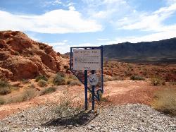
Arrowhead Trail is a 2.4 mile hiking and mountain biking trail within Thunderbird Conservation Park. This trail is manageable enough for beginners, but offers enough challenge for more experienced hikers and bikers.
Arrowhead Trail is easiest accessed by way of Whip Trail. The trail is rocky, with several switchbacks, and a decent mix of steeper terrains and more shallow, even sections. About 1 mile into the hike, a top a summit there is an American Flag that flows, surrounded by the views of the desert valley and mountain peaks on the horizon, this is a great picture spot. A half mile further from that spot there is a ramada style shelter spot with picnic tables, where you can rest and enjoy a snack or drink.
The most rugged of the Thunderbird Park trails, this trail has typical Sonoran Flora, including Saguaro, Barrel, Cholla, and Buckhorn Cactus, along with Palo Verde, Creosote, Brittlebush and Perennials depending on rainfall. I've seen a number of Coyotes over the years, as well as some nice lizards.Courtesy of hikearizona.com
The parking lot is locked and closed from sunset to sunrise. This is a pet friendly trail, but it gets a fair amount of traffic, so it's encouraged to keep your pets leashed.
More Information
Arrowhead Point (H2) Mountain Bike Trail, Glendale, Arizona
A mile and a half hike-a-bike with staircase switchbacks and killer views. Near Glendale, Arizona.
https://www.mtbproject.com/trail/7000561/arrowhead-point-h2Never modify trail features. Ride trails when they're dry enough that you won't leave ruts. Speak up when you see others on the trail and always yield to hikers, horses, and others coming uphill. Always ride on the established trail.
Read MoreBe courteous, informed, and prepared. Read trailhead guidelines, stay on the trail, and don't feed the wildlife.
Read More
- Plan Ahead and Prepare
- Travel & camp on durable surfaces
- Dispose of waste properly
- Leave what you find
- Minimize campfire impacts
- Respect wildlife
- Be considerate of other visitors
Directions
From Glendale, Arizona
- Head northwest on US-60 W/Grand Ave toward W Myrtle Ave (5.5 mi)
- Turn right onto N 91st Ave (0.2 mi)
- Take the Arizona 101 Loop N ramp (0.5 mi)
- Merge onto AZ-101 Loop N (6.8 mi)
- Take exit 19 for 59th Ave (0.3 mi)
- Merge onto W Beardsley Rd (433 ft)
- Turn left onto N 59th Ave (2.3 mi)
- Continue onto W Pinnacle Peak Rd (0.2 mi)
- Turn right (0.1 mi)


Other Mountain Bike Trails and Hiking Trails Nearby

Thunderbird H-2 Trail
Glendale, Arizona
0.0 miles SEA steady, non-strenuous hike to the summit of Thunderbird with slightly rocky sections and an American flag planted at the top in a rock pile — 1 to 3 hours round trip.
Hike 
Thunderbird H-1 H-2 H-3 Loop Trail
Glendale, Arizona
0.0 miles SWHike and Mountain Bike near Glendale, Arizona
Hike, Mountain Bike 
H-1 to H-4 Trails Loop
Glendale, Arizona
0.9 miles SWOver 20 miles of H-Trails winding through the Hedgpeth Hills in Glendale, with routes ranging from 0.75 to 5 miles and elevation gains up to 550 feet — mix and match for a custom loop.
Hike, Mountain Bike 
Dixie mountain
Glendale, Arizona
1.5 miles WA beginner-to-intermediate trail network in Glendale with connectable loops and a link to the north Sonoran Preserve via connector trail — customize your distance and difficulty.
Mountain Bike 
Thunderbird Park
Phoenix, Arizona
2.0 miles NWA rocky Phoenix mountain bike trail with no shade and plenty of heat — full suspension recommended, and bring extra water.
Mountain Bike 
Sonoran Preserve North
Phoenix, Arizona
2.0 miles NWRolling singletrack with sustained climbs and flowy downhills — string together 20-plus miles and nearly 4,000 feet of climbing on this pump-friendly hard-tail terrain.
Mountain Bike 
Deem Hills Circumference Trail with Summit
Phoenix, Arizona
2.2 miles NA just-under-6-mile circumference trail looping two desert hills in Deem Hills Recreation Area, with a ridge summit option offering great overlooks and about 600 feet of total elevation gain.
Hike 
Deem Hills Circumference Trail
Phoenix, Arizona
2.2 miles NA 10.5-mile moderate mountain bike loop near Phoenix that's primarily used for riding — a straightforward circumference route around Deem Hills.
Hike, Horseback, Mountain Bike 
Deem Hills East Trail
Phoenix, Arizona
3.2 miles NEA newer, less-crowded Phoenix park with a just-under-6-mile loop around two hills and more demanding terrain on the east side — well-cut desert trail with a Basalt shortcut option.
Hike 
Deem Hill
Phoenix, Arizona
3.2 miles NEA fast after-work mountain bike loop with 650 feet of climbing via switchbacks, rocky sections, several loop options, and fun downhill runs back to the trailhead.
Mountain Bike 
Deem Hills Inner Loop
Phoenix, Arizona
3.2 miles NEHike and Mountain Bike near Phoenix, Arizona
Hike, Mountain Bike 
Palisade to Basalt to Circumference Trail Loop
Phoenix, Arizona
3.2 miles NEHike near Phoenix, Arizona
Hike 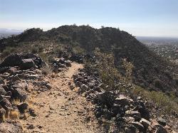
Sunrise Mountain Trail
Peoria, Arizona
4.6 miles NWThree sequential loop trails in suburban Peoria starting from Westwing Park — each loop harder than the last, with views of Glendale, Peoria, and Phoenix from the trail.
Hike, Mountain Bike 
West Wing Mountain Advanced Trail
Peoria, Arizona
4.8 miles NWHike near Peoria, Arizona
Hike 
Sonoran Trail
Phoenix, Arizona
5.5 miles NEA smooth, hilly 10–12 mile loop trail in Phoenix with well-marked intersections — suitable for a range of riders, though beginners should pace themselves.
Mountain Bike 
Union Peak Loop
Phoenix, Arizona
5.5 miles NEHike near Phoenix, Arizona
Hike 
Hawk's Nest/Desert Tortoise/Dixie Mountain Loop
Phoenix, Arizona
5.5 miles NEA moderate desert loop through creeks and hills with great scenery in Phoenix's Sonoran Preserve — connects Hawk's Nest, Valle Verde, and Dixie Mountain trails.
Hike, Horseback, Mountain Bike 
Hawk's Nest Trail and Dixie Mountain Loop
Phoenix, Arizona
5.5 miles NEA moderate connector trail in Phoenix's Sonoran Preserve that links the trailhead to Desert Tortoise Trail and Dixie Mountain Loop — good hiking boots recommended.
Hike, Horseback, Mountain Bike 
Dixie Mountain Loop with Two Summits
Phoenix, Arizona
5.5 miles NEHike, Horseback, and Mountain Bike near Phoenix, Arizona
Hike, Horseback, Mountain Bike 2.8 mi
Desert Tortoise
Phoenix, Arizona
5.5 miles NEA doubletrack desert connector and loop trail with reasonable elevation changes and close-proximity Cholla cactus lining the path — good hiking shoes and a leashed dog are a must.
Hike, Mountain BikeNearby Campsites

Lower Salt River Nature Trail
Fort McDowell, Arizona
31.6 miles EA 2-mile beginner loop alongside the Salt River in Tonto National Forest, with worn markers that keep things adventurous — watch for wild horses and spring cactus blooms.
Camp, Hike 
Buckhorn Campground Nature Trail
Apache Junction, Arizona
35.7 miles SECamp and Hike near Apache Junction, Arizona
Camp, Hike


