


Buddle Creek Swim Area
Lexington
Canoe, Kayak, and Swim
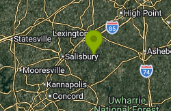
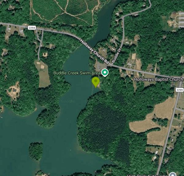
Buddle Creek Swim Area is a roped public swimming area at the Buddle Creek access area on High Rock Lake, the Yadkin River reservoir that straddles Davidson and Rowan counties. It sits in the Davidson County cove where Buddle Branch enters the Abbotts Creek arm of the lake, about 10 miles south of downtown Lexington and a few miles east of Southmont. The site is part of the Yadkin Hydroelectric Project, now owned by Cube Yadkin Generation, and state boating rules for Davidson County name it as one of two marked public swimming areas on the Davidson side of the lake, the other being Pebble Beach on Flat Swamp Creek.
The entrance is off Holloway Church Road (the commonly listed address is 2882 Holloway Church Road, Lexington). A paved access road runs down to a large paved lot that serves both the boat ramp and the beach, so there is no long walk from the car. The double-lane concrete ramp and floating dock are at the north end of the shoreline, and the swim area lies just south of them. Picnic tables sit on two shaded grass areas between the lot and the water, and the site has had portable toilets rather than a bathhouse. The access road has a gate, and posted hours were not available when this listing was written, so plan on daylight use.
The beach itself is a narrow strip, roughly 200 feet long, that has been described over the years as both gravel and sand. An inner and outer line of floating buoys marks the swimming zone, and state rules bar any boat from entering the water east of the ropes. Swimming is allowed only inside the buoyed area; signs at the ramp mark the launch zone as no swimming, and fishing inside the swim area is prohibited. There are no lifeguards. A rescue ring station and a life jacket loaner station have been placed near the beach, and children and weak swimmers should wear a jacket. High Rock is a shallow, warm Piedmont reservoir, so by midsummer the water in the cove is bathwater-warm, and there is no current to speak of.
No entrance, parking or day-use fee is posted for the Buddle Creek access area, so the beach is free to use. It is a public project recreation site open to anyone, not a residents-only or subdivision beach, and it has been in public use since the access area was built in 1980.
Water quality is the main thing to check before a visit. Yadkin Riverkeeper samples Buddle Creek for E. coli weekly from late May through early September and posts results to the Swim Guide app and website. Buddle Creek has passed most weeks, but bacteria levels on High Rock Lake can spike for a day or two after heavy rain, so skip the swim after a storm and look at the latest result first. Boat traffic is heavy on summer weekends; the water within 50 yards of the ramp and dock is a no-wake zone, but swimmers should stay well clear of the launch lane. High Rock is a working hydropower reservoir, and its level can be drawn down by several feet, which shifts the waterline away from the beach, mostly outside the summer season.
Beyond swimming, the site is a busy launch for anglers and a stop on the Yadkin-Pee Dee River Trail, so kayakers and canoeists use the ramp to explore the quiet Buddle and Abbotts Creek coves. There is bank fishing along several hundred feet of shoreline outside the swim area.
More Information
Buddle Creek Swim Area - Swim Guide
The Buddle Creek Swim Area is a combination boat access and designated swim area on High Rock Lake. It features a sandy beach area with floating booms, and porta-a-jons on site.
https://www.theswimguide.org/beach/9736Cube Hydro - Committed to the Betterment of High Rock Lake - Live Original
Cube Hydro Carolinas is striving to keep High Rock Lake environmentally friendly and accessible.
https://yourrowan.com/?p=3547High Rock Lake NC: Fishing, Boating & Visitor Guide
Plan your visit to High Rock Lake in Salisbury NC. Boat ramps, best fishing spots, swim areas, waterfront dining, and lakeside camping details.
https://www.visitrowancountync.com/blog/post/guide-to-high-rock-lake-in-salisbury-nc/SWIM GUIDE — Yadkin Riverkeeper
We are an environmental nonprofit dedicated to respecting, protecting and improving the Yadkin River Basin in North Carolina through education, advocacy and action. Please join us in our fight!
https://www.yadkinriverkeeper.org/swim-guide
- Plan Ahead and Prepare
- Travel & camp on durable surfaces
- Dispose of waste properly
- Leave what you find
- Minimize campfire impacts
- Respect wildlife
- Be considerate of other visitors
Directions
From Lexington
- Head northwest on Red Mile Rd toward Tattersalls Way (0.1 mi)
- Make a U-turn at Tattersalls Way (0.1 mi)
- Turn left onto S BroadwayPass by Starbucks Coffee Company (on the right)(4.1 mi)
- Turn left to merge onto I-64 E/
I-75 S toward Knoxville/ Ashland (2.4 mi) - Keep left to continue on I-64 E, follow signs for Winchester/
Ashland Entering West Virginia(169 mi) - Slight right to stay on I-64 E (signs for Beckley)Toll road(55.0 mi)
- Keep left to continue on I-64 E/
I-77 S (5.2 mi) - Slight right onto I-77 SToll roadEntering Virginia(66.8 mi)
- Take the exit onto I-77 S/
I-81 N/ US-52 S toward Charlotte/ Roanoke Continue to follow I-77 S/(8.8 mi)I-81 N - Take exit 81 for I-77 S toward Charlottte NC (0.4 mi)
- Continue onto I-77 SEntering North Carolina(36.7 mi)
- Keep left to continue on I-74, follow signs for Mt Airy/
Winston - Salem (12.7 mi) - Continue onto US-52 S (20.5 mi)
- Keep right to stay on US-52 S (12.5 mi)
- Continue onto I-285/
US-52 S (13.7 mi) - Take exit 92 for NC-8 toward Lexington (0.3 mi)
- Turn left onto NC-8/
Old U.S. Hwy 52 Continue to follow NC-8(3.0 mi) - Turn left onto W 5th St (0.7 mi)
- W 5th St turns slightly right and becomes W M.L.K. Jr Blvd/
Raleigh Rd Continue to follow Raleigh Rd(1.4 mi) - Continue onto E Old Hwy 64 (1.4 mi)
- Turn right onto Becks Church Rd (3.8 mi)
- Turn left onto NC-47 E (1.2 mi)
- Slight right onto Parks Rd (2.6 mi)
- Turn right onto Holloway Church Rd (1.7 mi)
Other Swimming Holes, Canoeing Areas, and Kayaking Areas Nearby
Nantahala Gorge Area
Trinity, North Carolina
13.9 miles NEMultiple swimming places — several clothing-optional — near the Nantahala River and Gorge in western North Carolina, ranging from roadside to remote canyon spots.
Swim
Little Uwaharrie River
Trinity, North Carolina
13.9 miles NESwim near Trinity, North Carolina
Swim
Kings Mountain Point Day Use Area
Troy
17.9 miles SEFree Forest Service day-use area on a wooded peninsula in Badin Lake, Uwharrie National Forest, with unguarded shoreline swimming, picnic sites, fishing piers and lake trail access.
Hike, Swim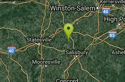
Bullhole
Woodleaf, North Carolina
20.7 miles NWSwim near Woodleaf, North Carolina
Swim
Lake Norman State Park Swim Beach
Troutman
40.5 miles WA lifeguarded sand beach on the north shore of Lake Norman inside Lake Norman State Park near Troutman. Park entry is free; a state swim pass ($6 adults, $4 kids 3 to 12) is required in season.
Camp, Canoe, Hike, Kayak, Swim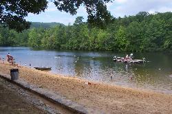
Hanging Rock State Park Lake
Danbury
49.0 miles NA 12-acre lake built by the Civilian Conservation Corps in Hanging Rock State Park, with a sandy swim beach and lifeguards in front of a 1939 stone bathhouse. Open Memorial Day to Labor Day; $6 adults, $4 kids.
Camp, Hike, SwimNearby Campsites
Lake Norman State Park Swim Beach
Troutman
40.5 miles WA lifeguarded sand beach on the north shore of Lake Norman inside Lake Norman State Park near Troutman. Park entry is free; a state swim pass ($6 adults, $4 kids 3 to 12) is required in season.
Camp, Canoe, Hike, Kayak, Swim
Hanging Rock State Park Lake
Danbury
49.0 miles NA 12-acre lake built by the Civilian Conservation Corps in Hanging Rock State Park, with a sandy swim beach and lifeguards in front of a 1939 stone bathhouse. Open Memorial Day to Labor Day; $6 adults, $4 kids.
Camp, Hike, Swim


