


6 Hiking Trails near Buckeye Park
first prev 1 next lastShowing Hiking Trails within 50 miles Distance miles of Buckeye Park near Redding, California City, Zip, or Address
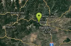
Whiskeytown lake
Redding, California
6.2 miles WSapphire-blue waters surrounded by mountain peaks, four waterfalls, pristine mountain creeks, 70 miles of trails, and Gold Rush history — all within 39,000 acres near Redding.
Hike
Whiskeytown Falls
French Gulch, California
14.3 miles WOne of the best waterfalls in Northern California hides at the west end of Whiskeytown Lake, reached by a 1.7-mile uphill hike — bring extra water for this strenuous climb.
Hike
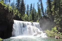
Middle McCloud Falls
McCloud
47.0 miles NEA 50-foot waterfall on the upper McCloud River in Shasta-Trinity National Forest with a big, cold plunge pool. Free to visit, reached by trail from Lower Falls or a short descent from the Middle Falls overlook.
Camp, Hike, Swim 0.3 mi
Burney Falls
Burney, California
47.4 miles NEA 129-foot year-round waterfall draped in green fern curtains in Shasta County — accessible from a parking lot with multiple trail angles, best visited early morning or just before sunset.
Hike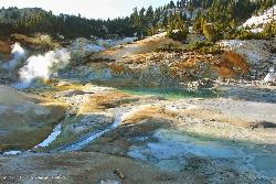
Bumpass Hell
48.1 miles E
A 3-mile round-trip hike through Lassen Volcanic National Park's largest hydrothermal area, where boiling pools, steam vents, and mud pots including a 322°F fumarole make a dramatic — but boardwalk-only — spectacle.
Hike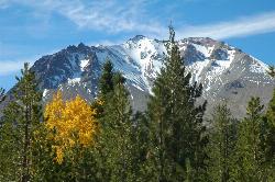
Lassen Peak
Mineral, California
48.4 miles EThe world's largest plug dome volcano rises to 10,457 feet in Lassen Volcanic National Park — a steep 5-mile round trip with 2,000 feet of gain and views of the Devastated Area below.
Backpack, Hike


