


Map of 125 Hiking Trails near Black Canyon City, AZ 85324
first prev 1 2 3 4 5 6 7 next lastShowing Hiking Trails within 50 miles Distance miles of Black Canyon City, AZ 85324, USA City, Zip, or Address

L.V. Yates Trail (#8)
Phoenix, Arizona
35.9 miles SThe trail is strewn with large rocks and gulleys from recent torrential rains. Not impassable on foot, but definitely some hike-a-bike areas. Keep in mind there's no ridge hiking...
Hike, Horseback, Mountain Bike 7.1 mi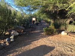
Trail 100
Phoenix, Arizona
36.4 miles SMountain Bikers and Hikers in Phoenix, Arizona can rejoice in the challenge that is Trail 100. Trail 100, or Charles M. Christensen Memorial Trail, is a little over 14 miles out and back in the...
Hike, Mountain Bike 3.6 mi
Charles M. Christiansen Memorial Trail
Phoenix, Arizona
36.4 miles SPhoenix, Arizona is home to some of the best and largest city parks in the country and the Charles M. Christiansen Memorial Trail is a great introduction to this fantastic park system. Also known as...
Hike, Horseback, Mountain Bike 3.7 mi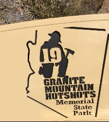
Granite Mountain Hotshots Memorial
Yarnell, Arizona
36.8 miles WFrom the Observation Deck, you can see the Fatality Site 400’ below and the Town of Yarnell to the east. Additional interpretive signage outlines the tragic events of the Yarnell Hill Fire. A...
Hike
Indian Bend Bike Trail
Scottsdale, Arizona
36.9 miles SEIndian Bend Wash Greenbelt is a urban, concrete paved path, primarily used for biking and walking/jogging, in Scottsdale, Arizona. This point A to point B, 11 mile long trail takes you past parks,...
Hike, Mountain Bike 4.6 mi
Perl Charles Memorial Trail (#1A)
Phoenix, Arizona
37.1 miles SThis is a technical singletrack loop with some very steep up and down sections located in the Phoenix Mountain Preserves. This trail is for advanced riders who like to bleed and leave their skin on...
Hike, Horseback, Mountain Bike
Thompsons Peak
Fountain Hills, Arizona
37.2 miles SEHike near Fountain Hills, Arizona
Hike
Dixie Mine
Fountain Hills, Arizona
37.2 miles SEMcDowell Mountain Regional Park 16300 McDowell Mountain Park Dr. MMRP Arizona 85255 Ph: 480-471-0173 Fax: 602-372-8507 mcdowellpark@mail.maricopa.gov Mailing...
Hike
Sonoran Trail Fountain Hills
Fountain Hills, Arizona
37.3 miles SEHike near Fountain Hills, Arizona
Hike 1.9 mi
Ruth Hamilton Trail
Phoenix, Arizona
37.4 miles SHike and Mountain Bike near Phoenix, Arizona
Hike, Mountain Bike 1.4 mi
Mohave Trail (#200)
Phoenix, Arizona
37.4 miles SAn invigorating swift hike is what Mohave Trail 200 provides for anyone looking for a free and quick escape. Though the main attraction of the Phoenix Mountain’s Preserve is the larger Piestewa...
Hike, Horseback 2.2 mi
Piestewa Peak Summit Trail #300
Phoenix, Arizona
37.4 miles SSome people still refer to the Peak by its original name of "Squaw Peak" before its name changed to "Piestewa Peak" in honor of Lori Piestewa who died serving her country in the...
Hike 3.8 mi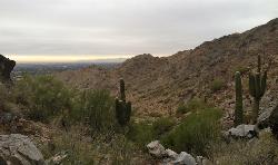
Freedom Loop Trail (#302)
Phoenix, Arizona
37.4 miles SFreedom Trail (#302), also known as Piestewa Circumference, is a 3.8 mile, moderate loop trail. You can access this trail from all the inner trailheads. The easiest and least...
Hike 0.4 mi
Clear Creek Campground
Camp Verde, Arizona
37.7 miles NEWest Clear Creek flows along the boundary of this desert canyon country camp and is a popular place for hiking, swimming, wading and fishing. Cool water species such as smallmouth bass and green...
Camp, Hike, Swim 1.7 mi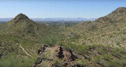
Quartz Ridge Trail
Phoenix, Arizona
38.1 miles SThis is a very popular trail on weekend mornings. Casual hikers can get great views of Phoenix with moderate effort. Good place to bring out of town visitors The Quartz Ridge Trail is a short,...
Hike, Mountain Bike 1.1 mi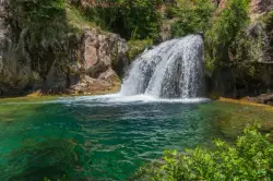
Fossil Creek Waterfall
Pine, Arizona
38.3 miles NEFossil Creek is one of Arizona's two designated "Wild and Scenic" rivers. The waterfall is the most popular place to visit to cool off and see the natural beauty. Located between...
Hike, Swim
Arizona Canal Trail
Phoenix, Arizona
38.7 miles SMulti-purpose canal trails set apart from normal city traffic and noise. The Arizona Canal is one of the many canals used to supply the valley with its water needs (irrigation). These canals were...
Hike, Horseback
Mule Deer Trail (Maricopa Trail)
Waddell, Arizona
39.0 miles SWMule Deer trail is a 3.5 mile out-and-back trail that it part of the Maricopa Trail within White Tank Mountain Regional Park. This is a beginner to moderate friendly trail for both hikers and...
Hike, Horseback, Mountain Bike
Wildlife Trail
Waddell, Arizona
39.0 miles SWA short trail which terminates at a small pond.
Hike, Horseback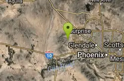
Black Rock Loop Trail
Waddell, Arizona
39.3 miles SWBlack Rock Trail is a 1.3 mile loop trail located near Waddell, Arizona and is good for all skill levels. The trail is primarily used for hiking and is accessible year round. Black...
Hike


