


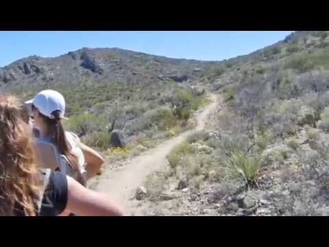
L.V. Yates Trail (#8)
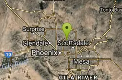
Phoenix, Arizona

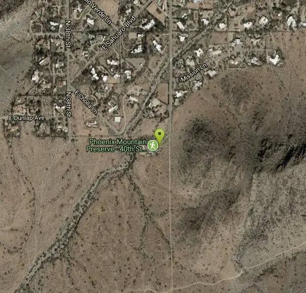
| Address: | ~9202 N 40th St, Phoenix, AZ 85028, USA |
| GPS: |
33°34'4.2"N 111°59'46.1"W Maps | Directions |
| State: | Arizona |
| Trail Length: | 4.00 miles |
| Trail Type: | Out & Back |
| Hike Difficulty: | Intermediate |
| Elevation Gain: | 577 feet |
| Trails/Routes: | 2.6 mi |
Pet Friendly
Hike, Horseback, and Mountain Bike
The trail is strewn with large rocks and gulleys from recent torrential rains. Not impassable on foot, but definitely some hike-a-bike areas. Courtesy of trailforks.com
Keep in mind there's no ridge hiking involved. The hike consist of a couple ravines seperated by two saddles. Quartz Ridge is what you're going over as described as the first saddle above. Courtesy of hikearizona.com
More Information
Never modify trail features. Ride trails when they're dry enough that you won't leave ruts. Speak up when you see others on the trail and always yield to hikers, horses, and others coming uphill. Always ride on the established trail.
Read MoreBe courteous, informed, and prepared. Read trailhead guidelines, stay on the trail, and don't feed the wildlife.
Read More- Plan Ahead and Prepare
- Travel & camp on durable surfaces
- Dispose of waste properly
- Leave what you find
- Minimize campfire impacts
- Respect wildlife
- Be considerate of other visitors
Directions
From Phoenix, Arizona
- Head west on W Washington St toward 1st Ave (0.5 mi)
- Turn right onto N 7th Ave (0.2 mi)
- Continue straight to stay on N 7th Ave (0.6 mi)
- Turn right to merge onto I-10 E toward Tucson (2.3 mi)
- Take exit 147A-147B for AZ-51 N (0.6 mi)
- Continue onto AZ-51 N (8.7 mi)
- Take exit 9 for Shea Blvd (0.3 mi)
- Keep right at the fork and merge onto E Shea Blvd (0.8 mi)
- Turn right onto N 40th St (1.0 mi)

Trails
Distance ?
2.6 milesElevation Gain ?
-78 feetReal Ascent ?
630 feetReal Descent ?
708 feetAvg Grade (0°)
-1%Grade (-16° to 15°)
-29% to 28%Elevation differences are scaled for emphasis. While the numbers are accurate, the cut-away shown here is not to scale.
Other Mountain Bike Trails, Hiking Trails, and Horseback Trails Nearby
L.V. Yates to "Two Bit" Peak Loop
Phoenix, Arizona
0.0 miles WWell this time of the year there really was not a lot of wild life to see, just to hot. Starting from the 40st trailhead gave me a different view of the preserve. I really enjoyed...
Hike, Horseback 4.6 mi
Mystery Loop
Phoenix, Arizona
0.1 miles NThe trail is a nice combination of technical rock trail, washes, and climbs. There is a large network of trails to make the ride longer or shorter depending upon your needs. These trails cross over...
Mountain Bike 7.1 mi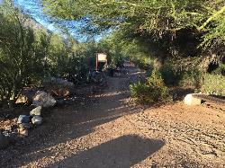
Trail 100
Phoenix, Arizona
1.0 miles EMountain Bikers and Hikers in Phoenix, Arizona can rejoice in the challenge that is Trail 100. Trail 100, or Charles M. Christensen Memorial Trail, is a little over 14 miles out and back in the...
Hike, Mountain Bike 3.6 mi
Charles M. Christiansen Memorial Trail
Phoenix, Arizona
1.1 miles EPhoenix, Arizona is home to some of the best and largest city parks in the country and the Charles M. Christiansen Memorial Trail is a great introduction to this fantastic park system. Also known as...
Hike, Horseback, Mountain Bike 1.9 mi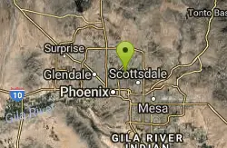
Ruth Hamilton Trail
Phoenix, Arizona
1.8 miles SHike and Mountain Bike near Phoenix, Arizona
Hike, Mountain Bike 4.8 mi
Trail 1A
Phoenix, Arizona
1.9 miles WThe trail can be accessed from the Dreamy Draw Park parking lot. From there, the trail can be ridden south towards its origin, or east (the trail makes an "L" shape). It is a mix of double...
Mountain Bike 1.3 mi
Dreamy Draw Loop Trail
Phoenix, Arizona
1.9 miles WThe Dreamy Draw Nature Trail is a short multi-access loop trail that provides a true Sonoran Desert experience. The trail crosses a number of desert washes and, at times, becomes somewhat rocky....
Hike, Horseback, Mountain Bike
Trail #100
Phoenix, Arizona
1.9 miles WFrom Dreamy Draw you can head NW on Trail 100 and immeadiately hit a ridge with good views. Ride on for 5 - 6 miles of nice single track and great views, to 7th and return. If you...
Mountain Bike 1.4 mi
Mohave Trail (#200)
Phoenix, Arizona
2.3 miles SWAn invigorating swift hike is what Mohave Trail 200 provides for anyone looking for a free and quick escape. Though the main attraction of the Phoenix Mountain’s Preserve is the larger Piestewa...
Hike, Horseback 2.2 mi
Piestewa Peak Summit Trail #300
Phoenix, Arizona
2.5 miles SWSome people still refer to the Peak by its original name of "Squaw Peak" before its name changed to "Piestewa Peak" in honor of Lori Piestewa who died serving her country in the...
Hike 3.8 mi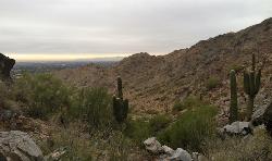
Freedom Loop Trail (#302)
Phoenix, Arizona
2.5 miles SWFreedom Trail (#302), also known as Piestewa Circumference, is a 3.8 mile, moderate loop trail. You can access this trail from all the inner trailheads. The easiest and least...
Hike 1.7 mi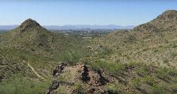
Quartz Ridge Trail
Phoenix, Arizona
2.6 miles SThis is a very popular trail on weekend mornings. Casual hikers can get great views of Phoenix with moderate effort. Good place to bring out of town visitors The Quartz Ridge Trail is a short,...
Hike, Mountain Bike 4.6 mi
Perl Charles Memorial Trail (#1A)
Phoenix, Arizona
3.2 miles SWThis is a technical singletrack loop with some very steep up and down sections located in the Phoenix Mountain Preserves. This trail is for advanced riders who like to bleed and leave their skin on...
Hike, Horseback, Mountain Bike 1.0-1.2 mi
Camelback Mountain
Phoenix, Arizona
3.5 miles SHiking After Camelback became a park in 1968, TripAdvisor advertised the hikes as one of the top 10 things to do when in Phoenix. Located right in the middle of Phoenix, Scottsdale and...
Hike, Rock Climb
Arizona Canal Trail
Phoenix, Arizona
3.6 miles SWMulti-purpose canal trails set apart from normal city traffic and noise. The Arizona Canal is one of the many canals used to supply the valley with its water needs (irrigation). These canals were...
Hike, Horseback
Shadow Mountain Trail
Phoenix, Arizona
3.9 miles NWThis particular route trailhead starts at 23rd place and Sweetwater rd it's a great wildlife trail.
Hike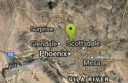
Murphy Bridle Path Trail
Phoenix, Arizona
4.0 miles WHorseback near Phoenix, Arizona
Horseback
North Mountain National Trail
Phoenix, Arizona
4.2 miles WNorth Mountain National Trail is a 2.3 mile moderate, loop trail near Phoenix. It's easy to travel on if you go up the paved sections. The inclines are steep in parts, making it a real...
Hike
Shaw Butte and Charles M Christiansen Loop Trail
Phoenix, Arizona
4.6 miles NWWhen you say "North Mountain," I think most Arizonans know where it is or can find it. When you say "Shaw Butte," it seems like you get a lot more questioning glances and "huh?". Shaw...
Hike, Mountain Bike
Maxine Lakin Nature Trail
Phoenix, Arizona
5.0 miles WHike near Phoenix, Arizona
HikeNearby Campsites

Lower Salt River Nature Trail
Fort McDowell, Arizona
19.4 miles EThe Lower Salt River Nature Trail is a scenic walk to take at the Tonto National Forest. This trail provides stunning views as you walk alongside the Salt River. This rustic trail is older and less...
Camp, Hike
Buckhorn Campground Nature Trail
Apache Junction, Arizona
22.6 miles ECamp and Hike near Apache Junction, Arizona
Camp, Hike


