


Map of 61 Hiking Trails near Bountiful, Utah
first prev 1 2 3 4 next lastShowing Hiking Trails within 50 miles Distance miles of Bountiful, UT 84010, USA City, Zip, or Address
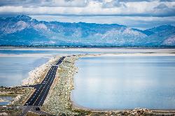
Antelope Island
Syracuse, Utah
21.8 miles NWAntelope Island State Park, the largest island in the Great Salt Lake, is home to a roaming herd of 500 bison. Pronghorn and bighorn sheep also share the rangelands that overlook the desert...
Hike, Horseback, Mountain Bike
Lake Blanche
Salt Lake City, Utah
21.9 miles SELake Blanche is a fun and popular hike. Lake Blanche, Lake Florence and Lake Lillian are all located next to each other in the upper reaches of the South Fork of Mill B. The trail to Lake Blanche...
Hike 1.1-4.7 mi

Bells Canyon
Sandy, Utah
22.8 miles SBells Canyon is a moderate, 4.5 mile hike that begins in a residential area and ends at a waterfall in the enter of the canyon's forest. The first 1/2 mile of the hike is relatively...
Backpack, Hike, Mountain Bike, Snowshoe 0.7 mi
Great White Icicle
Sandy, Utah
23.2 miles SThe Great White Icicle is located in Little Cottonwood Canyon just outside of Salt Lake City, Utah. It is a climbing area that is a frozen waterfall in the winter and a cascading waterfall...
Hike, Rock Climb
Lisa Falls
Sandy, Utah
23.3 miles SLisa Falls is a great place to climb Spring through Fall, any time of day. The base is well shaded by trees and offers many flat places to belay, or just hang out and relax. The roaring waterfall...
Hike, Rock Climb 0.2 mi
Rocky Mouth Trail/Waterfalls
Sandy, Utah
24.0 miles SThis adventure begins with a very scenic hike to a beautiful waterfall and ends with a magnificent rappel through a short slot canyon and down the waterfall. The hike to the waterfall is a great trip...
Canyoneer, Hike, Rock Climb
Pfeiferhorn Peak
Provo, Utah
24.1 miles SEThe Pfeifferhorn is a majestic peak, which is located east of Salt Lake City, Utah in the Wasatch mountain range. It's easy access, proximity to alpine lakes and short trail make it a popular...
Backpack, Hike 0.4 mi
Hidden Valley Park trail
Sandy, Utah
24.4 miles SHidden Valley Trail has different levels and gradual uphill fun and makes for a good adventure trail. It's a wide, shallow valley that is hidden from view; hence the name. The valley’s...
Hike, Mountain Bike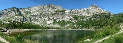
Silver Lake (Big Cottonwood)
Brighton, Utah
25.1 miles SEThis hike has everything. The trail passes by three bodies of water and winds through beautiful woodland areas. Wildlife is in abundance. Everything from chipmunks to moose can be observed along...
Hike, Mountain Bike 0.5 mi
Draper City Park
Draper, Utah
25.3 miles SDraper City Park is located in the center of the Draper Town Center and the park is near the Porter Rockwell Trail and Willow Creek Trail so visitors can walk or jog around. There are trail heads for...
Hike 0.8 mi
Bear Canyon Suspension Bridge
Draper, Utah
25.5 miles SThe Bear Canyon Suspension Bridge is a 185ft bridge that connects the Bear Canyon to the Bonneville Shoreline Trail. The bridge was built and completed in 2015 thanks to donations from residents and...
Hike, Mountain Bike 0.2 mi
Orson Smith trail
Draper, Utah
25.5 miles SOrson Smith Trail is located north of the Corner Canyon Gate. It leads up to the suspension bridge and has become a popular spot for hiking and bike routes since the suspension...
Hike, Mountain Bike
Cecret (Secret) Lake
Alta, Utah
25.9 miles SECecret (pronounced "Secret") Lake is a beautiful lake located among alpine meadows in Little Cottonwood Canyons Albion Basin. Some folks spell Secret Lake as Cecret Lake, but the USGS...
Hike
Wasatch Crest
Salt Lake City, Utah
26.0 miles SEThe Wasatch Crest Trail (GWT) is probably one of the best, if not the very best, singletrack trail in Utah! I prefer to do this ride as an out and back, starting at Millcreek Canyon's Big Water...
Hike, Mountain Bike
Sugarloaf Peak
Alta, Utah
26.1 miles SESugarloaf Peak is an easily reached 11,000 ft. summit which overlooks Albion Basin, Secret Lake, and much of Utah's Alta ski resort. The easy terrain and relatively high trailhead elevation...
Hike
American Fork Twin Peaks
Provo, Utah
26.1 miles SEAmerican Fork Twin Peaks is the highest mountain on the Little Cottonwood Canyon ridge. The summit is the prominent peak overlooking the Snowbird ski resort. A short approach hike...
Hike
White Pine Lake
Sandy, Utah
26.3 miles SEWhite Pine Canyon has long been the subject of intense controversy between advocates of wilderness and ski resort owners. The original boundaries of Lone Peak Wilderness Area, created in 1977, were...
Hike, Mountain Bike 1.6 mi
Corner Canyon Trail
Draper, Utah
26.6 miles SCorner Canyon is the "Go To" riding area in South Salt Lake and for many riders it is worth the drive (or ride) from Utah County. It is a good mix of everything from beginner training...
Backpack, Hike, Mountain Bike 0.6 mi
Bst To Equestrian Center Loop
Draper, Utah
26.6 miles SAn intermediate trail with a length of 10 miles that's located in Draper, UT. It's a single track look trail that has an elevation of 417 ft. Start at the Equestrian Center and follow the...
Hike, Mountain Bike 1.2 mi
Ghost Falls Trail
Sandy, Utah
27.5 miles SGhost Falls is located in the corner canyon riding area of Draper, Utah and one of the first mountain bike routes in the canyon. It's a family-friendly hike, named for the...
Hike, Mountain Bike, Snowshoe


