


White Pine Lake
Sandy, Utah

| GPS: |
40°32'29.4"N 111°40'46.1"W Maps | Directions |
| State: | Utah |
| Trail Length: | 10.50 miles |
| MTB Difficulty: | Intermediate |
| Trail Type: | Out & Back |
| Hike Difficulty: | Intermediate |
Trails Rocks Bicycles
Hike and Mountain Bike
White Pine Canyon has long been the subject of intense controversy between advocates of wilderness and ski resort owners. The original boundaries of Lone Peak Wilderness Area, created in 1977, were meant to include White Pine Canyon, but lobbyists representing Snowbird Ski Resort succeeded in having White Pine Canyon excluded. Hike this fantastic canyon and discover why everyone wants it. This trail is open to mountain bikes but they are extremely rare. This is an easy hike but a real grind on a mountain bike.
More Information
utahoutside.com is for sale — Get a price in 24 hours | Afternic
utahoutside.com is for sale on Afternic. Get a price in less than 24 hours from our domain experts.
https://forsale.godaddy.com/forsale/utahoutside.comWhite Pine Lake - Little Cottonwood Canyon - Hiking
White Pine Lake is a great hike located in the Wasatch Mountains. Information, guide and pictures.
https://www.climb-utah.com/WM/whitepine.htmWhite Pine Lake: An alpine escape in the Wasatch Mountains | The Active Explorer
Outdoor Adventure | Fitness | Self Exploration
https://www.theactiveexplorer.com/white-pine-lake-an-alpine-escape-in-the-wasatch-mountains/White Pine Trail
Whatever Utah experience you’re after — from hiking National Parks to touring Temple Square, you'll be able to tailor each detail of your trip, all in one spot.
https://www.utah.com/destinations/cities-towns/salt-lake-city/hiking/white-pine-trail/Never modify trail features. Ride trails when they're dry enough that you won't leave ruts. Speak up when you see others on the trail and always yield to hikers, horses, and others coming uphill. Always ride on the established trail.
Read MoreBe courteous, informed, and prepared. Read trailhead guidelines, stay on the trail, and don't feed the wildlife.
Read More- Plan Ahead and Prepare
- Travel & camp on durable surfaces
- Dispose of waste properly
- Leave what you find
- Minimize campfire impacts
- Respect wildlife
- Be considerate of other visitors
Directions
From Sandy, Utah
- Head east on E Sego Lily Dr toward S 1900 E (0.9 mi)
- Turn left onto S 2300 E/
Eastdell Dr (1.1 mi) - Turn right onto UT-209 E/
Little Cottonwood Rd (2.8 mi) - Slight right onto UT-210 E (6.8 mi)
- Turn right onto Bypass Rd (0.3 mi)
- Turn rightRestricted usage road(0.3 mi)
- Turn leftRestricted usage road(0.6 mi)
- Turn leftRestricted usage road(0.1 mi)
- Turn rightRestricted usage road(0.5 mi)
- Turn rightRestricted usage road(0.3 mi)
- Turn leftRestricted usage road(1.3 mi)
From I-15 in Sandy, Utah take Exit #298 (9000 South) and head east on Highway 209 (9000 South) for 6.9 miles at which point Highway 209 joins Highway 210 (Little Cottonwood Canyon Road) at a Y-Junction. All mileage in this canyon is measured from this Y-Junction. The junction is identified be a huge flashing message board on the south side of the road and a park and ride lot on the north side of the canyon. The park and ride lot has a restroom.
The White Pine Trailhead is located 5 1/2 miles up Little Cottonwood Canyon from the Y-Junction and 3/4 mile below Snowbird Ski Resort on the south side of the road. The Trailhead is signed with paved parking, vault toilet and information kiosk. Courtesy of climb-utah.com


Other Mountain Bike Trails and Hiking Trails Nearby

American Fork Twin Peaks
Provo, Utah
1.4 miles NEA high-elevation, intermediate-friendly peak scramble that doubles as a gateway to multi-summit ridge traverses — offering sweeping views over Snowbird ski resort from the alpine ridge.
Hike
Pfeiferhorn Peak
Provo, Utah
2.4 miles NAn easily accessible Wasatch peak east of Salt Lake City with alpine lakes below and mountain goats spotted regularly above — breathtaking views of the Salt Lake valley from one of the range's highest points.
Backpack, Hike
Lisa Falls
Sandy, Utah
3.3 miles NWA shaded granite climbing area in Little Cottonwood Canyon with polished friction faces, clean cracks, juggy overhangs, and a roaring waterfall that keeps the atmosphere cool and energizing.
Hike, Rock Climb
Sugarloaf Peak
Alta, Utah
3.3 miles NEAn easily reached 11,000-foot Wasatch summit overlooking Albion Basin, Secret Lake, and Alta ski resort — one of the easiest of the Wasatch 11ers with a high trailhead and gentle terrain.
Hike
Cecret (Secret) Lake
Alta, Utah
3.6 miles NEA short, easy alpine hike through Albion Basin meadows in Little Cottonwood Canyon leads to a beautiful mountain lake everyone can enjoy.
Hike 0.7 mi
Great White Icicle
Sandy, Utah
3.9 miles NWAn ice climb in winter and a waterfall rappel in summer just outside Salt Lake City — the Great White Icicle in Little Cottonwood Canyon offers four shelves of ice and a bucket-list 4-to-5-hour ascent for all seasons.
Hike, Rock Climb
Lake Blanche
Salt Lake City, Utah
4.5 miles NA popular 3-mile one-way hike in the Wasatch Mountains to three alpine lakes — Blanche, Florence, and Lillian — with plenty of water along the trail and about 2.5 hours to the top.
Hike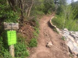
Tibble Fork
Provo, Utah
4.5 miles SEAn advanced and aerobic mountain bike ride out of Provo that climbs brutally through pine forests to the Great Western Trail, then drops 2,000 feet over 3 miles back to the trailhead.
Mountain Bike 3.2 mi
Little Cottonwood Pipeline Trail
Sandy, Utah
5.4 miles NWA single-track trail starting at the mouth of Little Cottonwood Canyon that stays smooth for the first mile, then gets rocky and steep — ending across a creek from historic ruins after 3.5 miles.
Mountain Bike 1.7 mi
Schoolhouse Springs Trail
Alpine, Utah
5.9 miles SWA short, scenic trail at 5,300 feet in Alpine, Utah, featuring a lake and activities from horseback riding to hiking — best enjoyed between May and October.
Hike, Mountain Bike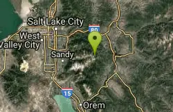
Brighton Lakes Loop
Salt Lake City, Utah
6.4 miles NEA challenging mountain bike loop past four alpine lakes — Dog, Mary, Martha, and Catherine — in Big Cottonwood Canyon, with a wild descent down the Lake Mary trail.
Mountain Bike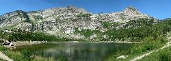
Silver Lake (Big Cottonwood)
Brighton, Utah
6.6 miles NEA Wasatch Mountains trail passing three alpine lakes, abundant wildlife from chipmunks to moose, shady forest, and sweeping views — with the option to hike counter-clockwise for a gentler climb.
Hike, Mountain Bike
Bear Canyon Loop
Provo, Utah
6.6 miles SAn advanced 8.4-to-longer-mile mountain biking loop through forested Wasatch switchbacks with 1,700 ft of elevation gain, steep rocky sections, and dramatic views from the ridge.
Mountain Bike
Storm Mountain
Salt Lake City, Utah
6.6 miles NWA compact Wasatch peak just 3 miles up Big Cottonwood Canyon, with rock climbing routes, hiking, biking, and Big Cottonwood Creek running right alongside the day-use area.
Hike, Mountain Bike, Rock Climb 0.2 mi
Rocky Mouth Trail/Waterfalls
Sandy, Utah
6.6 miles WAn easy 0.2-mile stroll from suburbia reaches a scenic waterfall at the canyon mouth, while climbers can push deeper for 60-ft and 70-ft rappels through a slot canyon.
Canyoneer, Hike, Rock Climb 1.1-4.7 mi
Bells Canyon
Sandy, Utah
6.7 miles WA 4.5-mile moderate hike up to a canyon waterfall through gorgeous fall foliage, meadows, wildflowers, and a creekside trail — the last 1.2 miles involve serious climbing over large rocks.
Backpack, Hike, Mountain Bike, Snowshoe
Hidden Falls
Salt Lake City, Utah
6.9 miles NA popular roadside waterfall in Big Cottonwood Canyon that's just a short stroll from the parking lot — a quick 15-minute detour with a big payoff.
Hike 1.5 mi
Timpanogas Cave
Provo, Utah
6.9 miles SColorful cave formations — cave bacons, columns, flowstone, and drapery — inside a Timpanogos mountain cave, reached by a 1.5-mile paved trail; tours run May through September.
Backpack, Cave, Hike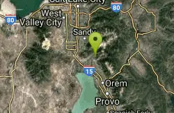
Rodeo Down
Alpine, Utah
7.0 miles SWA dense network of named mountain bike trails in Alpine — Black Dog, Brown Dog, Corkscrew, Flank, and more — with varied technical character, rock stunts, and elevation changes up to 300 feet.
Mountain Bike 0.4 mi
Hidden Valley Park trail
Sandy, Utah
7.0 miles WA hidden shallow valley of grass, sandstone cliffs, and Navajo Sandstone domes just south of Moab — loop options total about one mile, but bring water because it gets hot.
Hike, Mountain BikeNearby Campsites

Spruces Campground
Salt Lake City, Utah
7.2 miles NA fee campground in Big Cottonwood Canyon near Salt Lake City — check USDA.gov for current rates and seasonal availability.
Camp, Sled 1.6-14.1 mi
Mount Timpanogas
Provo, Utah
7.9 miles SUtah's most-climbed mountain towers 7,000 feet above the Provo valley, stretching seven miles north to south with multiple peaks over 11,000 feet — a Wasatch landmark.
Camp, Hike, Horseback, Swim
Mill Creek Canyon
Salt Lake City, Utah
11.1 miles NAn out-and-back canyon trail with over 1,000 feet of elevation gain — the lower ski trail sees heavy traffic while the upper section above Elbow Fork stays quiet, with a reservable Yurt at the top December through April.
Camp, Cross-country Ski, Snowshoe
Y-Mountain Summit Trail
Provo, Utah
20.8 miles SA 1.2-mile climb east of BYU leads to a massive block Y on the hillside and sweeping panoramas over Provo, Orem, Utah Valley, and Utah Lake below.
Camp, Hike
Holbrook Trailhead
Bountiful, Utah
25.0 miles NThe Holbrook Trailhead is a popular access point for the Bonneville Shoreline Trail and Holbrook Canyon above Bountiful, Utah, on the western face of the Wasatch. Perched on the bench right at the...
Airsoft, Backpack, Camp, Paintball, Snowshoe 4.7 mi
Fifth Water Hot Springs
Provo, Utah
35.9 miles SEA scenic 2.5-mile riverside hike to the famous Diamond Fork rock pools and waterfall, with soaks up to 108°.
Backpack, Camp, Hike, Hot Springs, Mountain Bike, Swim 5.6 mi
Antelope Island Lakeside Trail
Syracuse, Utah
44.4 miles NWAn easy 2-hour loop on Antelope Island around the Great Salt Lake, with rock formations, views of the Sierra Nevadas, and the GSL — kid-friendly and good for bug fans.
Camp, Hike, Horseback
Antelope Island State Park
Syracuse, Utah
44.6 miles NWTwenty miles of trails cross Utah's Great Salt Lake island alongside free-roaming bison, antelope, and bobcats — best visited in early spring or late fall to beat the bugs.
Backpack, Camp, Hike, Horseback, Mountain Bike
Hell Hole Lake
Evanston, Utah
46.9 miles EA challenging wash hike in Evanston's Dry Wash, navigating sand and boulders for 1.8 miles to Hellhole Canyon at the edge of the Red Mountain Wilderness.
Camp, Hike, Horseback


