


260 Things to do near Flying Dog Trail
first prev 3 4 5 6 7 8 9 10 11 12 next lastShowing results within 50 miles Distance miles of Glenwild Dr, Park City, UT 84098, USA City, Zip, or Address

Schoolhouse Springs Trail
Alpine, Utah
20.6 miles SWSchoolhouse Springs trail has an elevation trail at 5,300 ft. It's located at the end of the town of Alpine. It features a lake and there's a number of activities including horse-back...
Hike, Mountain Bike 0.2 mi
Orson Smith trail
Draper, Utah
20.7 miles SWOrson Smith Trail is located north of the Corner Canyon Gate. It leads up to the suspension bridge and has become a popular spot for hiking and bike routes since the suspension...
Hike, Mountain Bike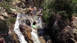
Alpine Rock Water Slide
Alpine, Utah
20.7 miles SWCLOSED. The land has been sold and the new owner has closed off the waterslide to the public. The Alpine Waterslide is a natural waterslide that surprisingly does not hurt your backside. However,...
Swim
Sandy Skatepark
Sandy, Utah
20.9 miles SWSkateboard near Sandy, Utah
Skateboard
Ridge Trail #157
Provo, Utah
20.9 miles SThis trail is 15.7 miles in length and is commonly referred as the backbone of the American Fork Canyon trail system, because it connects several loop routes along the northern portion of the...
Mountain Bike 0.8 mi
Bear Canyon Suspension Bridge
Draper, Utah
21.1 miles SWThe Bear Canyon Suspension Bridge is a 185ft bridge that connects the Bear Canyon to the Bonneville Shoreline Trail. The bridge was built and completed in 2015 thanks to donations from residents and...
Hike, Mountain Bike 1.6-14.1 mi
Mount Timpanogas
Provo, Utah
21.2 miles SMt. Timp, as the locals call it, is the 2nd highest mountain in the Wasatch range (only Mt. Nebo is higher). What sets "Timp" apart is its location. It towers over the Provo, Orem, Pleasant...
Camp, Hike, Horseback, Swim
Timpanooke
Provo, Utah
21.2 miles SThis is a great trail. Intermediate tech and moderate aerobic. It winds through pine forests and grass meadows. Start by heading down the Timpanooke section of the Great Western Trail...
Mountain Bike
Roots Disc Golf Course
Salt Lake City, Utah
21.5 miles WRebuilt at the location of Utah's 2nd known disc golf polehole course (1981-1986). The area hosted a par 3 ball golf course until a 2014 grant was awarded to the local club for the current...
Disc Golf
Bountiful City Park
Bountiful, Utah
21.6 miles NWLength: ~100-200ft Slope: ~45°
Sled 1.5 mi
Timpanogas Cave
Provo, Utah
21.6 miles SWKnown for it's colorful cave decorations, the Timpanogas cave attracts numerous visitors per year, is steep but it's paved so that visitors can access the cave. To access the cave, visitors...
Backpack, Cave, Hike
Deer Creek State Park
Wallsburg, Utah
21.8 miles SDeer Creek State Park is one of the finest year-round fishing spots in all of Utah. There are many different kinds of fish here and it is sure to not disappoint fisherman. Other...
Mountain Bike 0.5 mi
Draper City Park
Draper, Utah
21.8 miles SWDraper City Park is located in the center of the Draper Town Center and the park is near the Porter Rockwell Trail and Willow Creek Trail so visitors can walk or jog around. There are trail heads for...
Hike 1.7 mi
Jacob's Ladder Trail
Sandy, Utah
21.8 miles SWJacobs Ladder trail has an elevation trail of 5,700 ft. and the most popular trailhead out of the five trails in Lone Peak. It's located near a large area on the right side of the road...
Hike, Mountain Bike 1.2 mi
Ghost Falls Trail
Sandy, Utah
21.8 miles SWGhost Falls is located in the corner canyon riding area of Draper, Utah and one of the first mountain bike routes in the canyon. It's a family-friendly hike, named for the...
Hike, Mountain Bike, Snowshoe 0.2-1.8 mi
Lone Peak
Draper, Utah
21.9 miles SWEstablished in 1978 and located southeast of Salt Lake, Lone Peak is one of the taller peaks in the Wasatch range along the Wasatch Front. It has 5 main trailheads: Jacobs Ladder via Corner Canyon...
Hike, Mountain Bike, Rock Climb
Parrish Canyon Trail
Centerville, Utah
21.9 miles NWParrish Canyon Trail goes long the Wasatch Mountains; from the top of the mountain, this trail has beautiful views of Salt Lake City from a distance and interconnects with the Barnard Creek. It's...
Hike, Mountain Bike
Rodeo Down
Alpine, Utah
21.9 miles SWBlack Dog. Trail winds from the middle of Corkscrew down to Flank and River, just south of the water tank. Some technical aspects, length 0.5 miles with 300 vertical feet elevation...
Mountain Bike
Mills Park
Woods Cross, Utah
22.1 miles NWShort recreational course in multi-use park. Public (No Fee)
Disc Golf 0.6 mi
Bst To Equestrian Center Loop
Draper, Utah
22.4 miles SWAn intermediate trail with a length of 10 miles that's located in Draper, UT. It's a single track look trail that has an elevation of 417 ft. Start at the Equestrian Center and follow the...
Hike, Mountain Bike


