


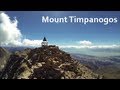
Mount Timpanogas
Provo, Utah

| Address: | Timpooneke Trailhead, Provo, UT 84604, USA |
| GPS: |
40°25'53.5"N 111°38'20.5"W Maps | Directions |
| State: | Utah |
| Trails/Routes: | 1.6-14.1 mi |
Camp, Hike, Horseback, and Swim
Mt. Timp, as the locals call it, is the 2nd highest mountain in the Wasatch range (only Mt. Nebo is higher). What sets "Timp" apart is its location. It towers over the Provo, Orem, Pleasant Grove area and its a very dominant feature. It rises 7000 feet from the valley floor and draws your gaze to it again and again.This mountain may be the most popular one in the state of Utah and is certainly the most climbed. Mt. Timpanogos is a huge mountain, extending almost seven miles in a north to south direction with many of its peaks reaching over the 11000 foot mark.
More Information
Mount Timpanogos - Wasatch Mountains - Hiking
Utah’s Mount Timpanogos is an exciting hiking adventure in the Wasatch Mountains. Route information, pictures, maps, GPS waypoints and description.
https://www.climb-utah.com/WM/timp.htmMount Timpanogos - Wikipedia
Mount Timpanogos, often referred to as Timp, is the second-highest mountain in Utah’s Wasatch Range. Timpanogos rises to an elevation of 11,752 ft (3,582 m) above sea level in the Uinta-Wasatch-Cache National Forest. With 5,270 ft (1,610 m) of topographic prominence, Timpanogos is the 47th-most prominent mountain in the contiguous United States.[3]
https://en.wikipedia.org/wiki/Mount_TimpanogosMt Timpanogos Summit via Timpooneke Trail
Mount Timpanogos is one of Utah’s most recognizable mountains, and perhaps Utah’s most popular mountain hiking destination. At 11,749 feet, it is the second-highest summit of the Wasatch Mountains (only Mt Nebo is higher).
https://www.utah.com/destinations/cities-towns/provo/hiking/mt-timpanogos-summit-via-timpooneke-trail/Mt. Timpanogos (UT) : Climbing, Hiking & Mountaineering : SummitPost
Mt. Timpanogos (UT) : SummitPost.org : Climbing, hiking, mountaineering
https://www.summitpost.org/mt-timpanogos-ut/151365Be courteous, informed, and prepared. Read trailhead guidelines, stay on the trail, and don't feed the wildlife.
Read More- Plan Ahead and Prepare
- Travel & camp on durable surfaces
- Dispose of waste properly
- Leave what you find
- Minimize campfire impacts
- Respect wildlife
- Be considerate of other visitors
Directions
From Provo, Utah
- Head west on E Center St toward N University Ave (1.5 mi)
- Take the ramp onto I-15 N (9.4 mi)
- Take exit 275 toward Pleasant Grove/American Fork (0.3 mi)
- Turn right onto Pleasant Grove Blvd (0.3 mi)
- Turn left onto N 2000 W St/N County BlvdContinue to follow N County Blvd(5.5 mi)
- Turn right onto W 11000 N (1.2 mi)
- Continue onto UT-92 E/Alpine Loop Scenic BywayMay be closed at certain times or days(8.4 mi)
- Turn right onto FR 056/Timpooneke Rd (0.3 mi)
- Turn left onto Timpooneke Trailhead (36 ft)
You can access Mt. Timpanogos easily from Highway I-15, using the 272 exit and driving east along highway 52 ( 800 North in Orem) to the junction with highway 189, the Provo Canyon road. Go East on 189 for 7 miles to the Sundance Ski resort turnoff (watch for it just after you go through a tunnel) and turn left on highway 92 for 6 miles, going past the Sundance ski area and the Aspen Grove recreation area. Proceed until you come to a fee booth (pay the fee ) and look for parking just beyond in a lot at the left. If full, look for additional parking just up the road. From the parking lot, you'll find the most popular trail, the Aspen Grove trail that heads on up the mountain


Other Swimming Holes, Hiking Trails, and Horseback Trails Nearby

Stewart Falls
Provo, Utah
2.6 miles SEA glacier-fed, 200-foot multi-tiered waterfall on Mt. Timpanogos — about a 4-mile round trip hike through forest with a few steep edges near the falls.
Hike
Timpanogos Falls
Provo, Utah
2.7 miles SEA lesser-known multi-tiered waterfall on the Mt. Timpanogos trail, visible early on and surrounded by wildflowers in late spring — a great beginner hike shared with the Stewart Falls trailhead.
Hike 1.5 mi
Timpanogas Cave
Provo, Utah
3.6 miles WColorful cave formations — cave bacons, columns, flowstone, and drapery — inside a Timpanogos mountain cave, reached by a 1.5-mile paved trail; tours run May through September.
Backpack, Cave, Hike
Grove Creek Trail
Pleasant Grove, Utah
5.4 miles SWA steep, shuttled downhill singletrack dropping from the shoulder of Mount Timpanogos through Grove Creek Canyon — the climb is brutal, but the descent is worth it.
Hike, Mountain Bike 1.2 mi
Battle Creek Falls
Pleasant Grove, Utah
5.7 miles SWA short 1.2-mile family-friendly hike in Pleasant Grove to a scenic waterfall with views from below and above, plus a nearby rappelling and rock climbing area just beyond the falls.
Canyoneer, Hike
G Mountain Trail
Pleasant Grove, Utah
5.7 miles SWA family-friendly 1.5-mile roundtrip hike from Kiwanis Park to a hillside 'G' landmark near Pleasant Grove — a little steep at the start and the end, but great for all ages.
Hike
Provo River Parkway Trail
Provo, Utah
6.3 miles SEA fully paved 6-mile canyon ride from Vivian Park to the mouth of Provo Canyon, passing waterfalls and a fish-feeding spot — best done with two cars for a car-shuttle downhill.
Hike, Mountain Bike 1.7 mi
Schoolhouse Springs Trail
Alpine, Utah
7.2 miles NWA short, scenic trail at 5,300 feet in Alpine, Utah, featuring a lake and activities from horseback riding to hiking — best enjoyed between May and October.
Hike, Mountain Bike
White Pine Lake
Sandy, Utah
7.9 miles NA canyon that ski resort lobbyists fought to keep out of wilderness, now open to hikers and rare mountain bikers — hike in and discover why everyone has been arguing over White Pine Canyon.
Hike, Mountain Bike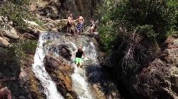
Alpine Rock Water Slide
Alpine, Utah
8.2 miles NWCLOSED. The land has been sold and the new owner has closed off the waterslide to the public. The Alpine Waterslide has been permanently closed to the public after the land was sold — new hiking trails now connect the area to the city trail system and National Forest.
Swim
American Fork Twin Peaks
Provo, Utah
8.4 miles NA high-elevation, intermediate-friendly peak scramble that doubles as a gateway to multi-summit ridge traverses — offering sweeping views over Snowbird ski resort from the alpine ridge.
Hike
Sugarloaf Peak
Alta, Utah
9.3 miles NAn easily reached 11,000-foot Wasatch summit overlooking Albion Basin, Secret Lake, and Alta ski resort — one of the easiest of the Wasatch 11ers with a high trailhead and gentle terrain.
Hike
Cecret (Secret) Lake
Alta, Utah
9.7 miles NA short, easy alpine hike through Albion Basin meadows in Little Cottonwood Canyon leads to a beautiful mountain lake everyone can enjoy.
Hike
Pfeiferhorn Peak
Provo, Utah
10.2 miles NAn easily accessible Wasatch peak east of Salt Lake City with alpine lakes below and mountain goats spotted regularly above — breathtaking views of the Salt Lake valley from one of the range's highest points.
Backpack, Hike
Mercer Hollow Trail
Draper, Utah
10.2 miles WA fast, flowy descent on the southern flank of Corner Canyon Ridge, packed with berms, rock features, rollers, and a quick uphill that rewards you on the way back down.
Hike, Mountain Bike 1.7 mi
Jacob's Ladder Trail
Sandy, Utah
10.3 miles NWJacob's Ladder is the steep, relentless local favorite for climbing into the Lone Peak Wilderness above Draper, Utah — and a legendary technical descent.
Hike, Mountain Bike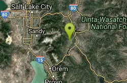
Homestead Crater
Midway, Utah
10.3 miles NEA natural hot spring inside a 10,000-year-old rock dome in Midway, Utah — accessed through a blasted tunnel, open year-round for scuba diving and swimming in mineral-rich waters.
Hot Springs, Swim 0.2-1.8 mi
Lone Peak
Draper, Utah
10.3 miles NWOne of the Wasatch Front's taller peaks at over 11,000 feet, Lone Peak offers five different trailhead approaches, a 9-mile average round trip, rugged canyon terrain, and stunning Salt Lake valley views.
Hike, Mountain Bike, Rock Climb 1.2 mi
Ghost Falls Trail
Sandy, Utah
10.3 miles NWA family-friendly hike in Corner Canyon that winds through sandy rocky slopes and dry creek beds to the Ghost Falls loop, with helpful trail signs at the confusing intersections.
Hike, Mountain Bike, Snowshoe 1.3 mi
Eagle Crest Trail
Draper, Utah
10.7 miles WA beginner-level 2.4-mile mountain bike trail along the north side of Traverse Mountain in Draper, with sweeping views of Salt Lake Valley, Mount Timpanogos, Lone Peak, and Box Elder Mountain.
Hike, Mountain BikeNearby Campsites

Y-Mountain Summit Trail
Provo, Utah
12.9 miles SA 1.2-mile climb east of BYU leads to a massive block Y on the hillside and sweeping panoramas over Provo, Orem, Utah Valley, and Utah Lake below.
Camp, Hike
Spruces Campground
Salt Lake City, Utah
14.5 miles NA fee campground in Big Cottonwood Canyon near Salt Lake City — check USDA.gov for current rates and seasonal availability.
Camp, Sled
Mill Creek Canyon
Salt Lake City, Utah
19.0 miles NAn out-and-back canyon trail with over 1,000 feet of elevation gain — the lower ski trail sees heavy traffic while the upper section above Elbow Fork stays quiet, with a reservable Yurt at the top December through April.
Camp, Cross-country Ski, Snowshoe 4.7 mi
Fifth Water Hot Springs
Provo, Utah
28.3 miles SEA scenic 2.5-mile riverside hike to the famous Diamond Fork rock pools and waterfall, with soaks up to 108°.
Backpack, Camp, Hike, Hot Springs, Mountain Bike, Swim
Holbrook Trailhead
Bountiful, Utah
32.9 miles NThe Holbrook Trailhead is a popular access point for the Bonneville Shoreline Trail and Holbrook Canyon above Bountiful, Utah, on the western face of the Wasatch. Perched on the bench right at the...
Airsoft, Backpack, Camp, Paintball, Snowshoe
Hell Hole Lake
Evanston, Utah
48.3 miles NEA challenging wash hike in Evanston's Dry Wash, navigating sand and boulders for 1.8 miles to Hellhole Canyon at the edge of the Red Mountain Wilderness.
Camp, Hike, Horseback


