


57 Things to do near Gaylor Lakes
first prev 1 2 3 next lastShowing results within 50 miles Distance miles of Gaylor Lake Trail, California, USA City, Zip, or Address
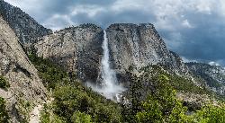
Upper Yosemite Falls
Yosemite Valley, Yosemite National Park
20.4 miles SWYosemite Falls is the tallest waterfall in North America, standing at 2,425 feet. It's made up of Upper Yosemite Falls, Lower Yosemite Falls, and the middle cascades. Lower Yosemite Falls...
Hike
Merced River
Yosemite Valley, Yosemite National Park
20.9 miles SWThe main fork of Merced River at Yosemite National Park is a perfect place to fish, swim, raft, and even pan for gold. The river circles around the center of Yosemite Valley, and almost every...
Camp, Swim, Whitewater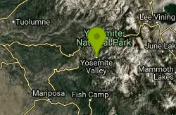
Harden Lake
Big Oak Flat, Yosemite National Park
20.9 miles WThe hike to Harden Lake at Yosemite is essentially a long walk. Much of the trail is walking down Tioga Road, an old gravel street that has been part of Yosemite since its foundation. The trail is...
Backpack, Hike 0.3 mi
Glacier Point
Yosemite National Park
20.9 miles SWLocated in Yosemite National Park, Glacier Point gives a birds-eye-view of the park you can't find anywhere else. It can be accessed by both hiking and driving through the park, though the roads...
Hike 0.4-2.1 mi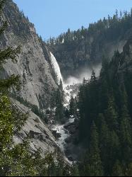
Illilouette Falls
Yosemite West, Yosemite National Park
21.1 miles SWIllilouette Falls Trail is a 4 mile hike down to Illilouette Creek, where there is a footbridge, a great view of Illilouette Falls, and several benches for onlookers to stop, rest, and...
Hike 0.7 mi
Cook's Meadow Loop
Yosemite Valley, Yosemite National Park
21.2 miles SWCook's Meadow Loop is a shorter, smaller hike inside Sentinel Meadow. Cook's Meadow Loop is just under a mile and takes about 45 minutes to complete, depending on how long you stop at each...
Hike 0.8 mi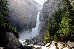
Lower Yosemite Falls
Yosemite Valley, Yosemite National Park
21.3 miles SWYosemite Falls is 3,967 feet high, making it twice as tall as the Empire State building, ten times as tall as Niagara Falls, and one of Yosemite Valley's biggest attractions. Lower...
Hike 4.6 mi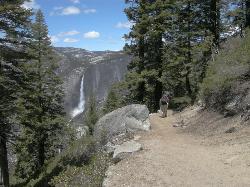
Four Mile Trail
Yosemite National Park
21.4 miles SWFour Mile Trail is a moderate hike that offers the best views of some of Yosemite's most famous landmarks, including Yosemite Falls, Half Dome, Clouds Rest, North Dome, El Capitan, and the Royal...
Hike 15.9 mi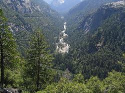
Valley Loop Trail
Yosemite Valley, Yosemite National Park
22.2 miles SWThe Valley Loop trail at the heart of Yosemite is one of the best ways to discover the park. The entire loop is 11.5 miles long, and there are several places to enter and exit the trail...
Hike 1.2 mi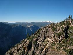
Taft Point
Yosemite Valley, Yosemite National Park
23.0 miles SWThe hike to Taft Point is often paired with the hike to Sentinel Dome. There is a 5 mile loop that connects the two and offers breathtaking views of the valley along the south rim. The trailhead...
Hike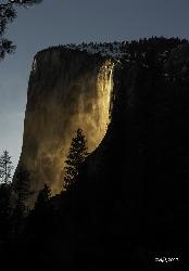
Horsetail Falls
Yosemite Valley, Yosemite National Park
23.4 miles SWHorsetail Falls is located near El Capitan Valley in Yosemite. Around mid to late February, the fall gains popularity due to the way the orange glow of the sunset radiates off of it. In order to...
Hike 1.7 mi
Mono Meadow
Yosemite West, Yosemite National Park
24.0 miles SWThe hike through Mono Meadow is the best way to get a view of Mt. Starr King, Clarke Range, and Half Dome all at once. It's about a three mile round trip hike towards Yosemite backcountry. It...
Hike 0.2 mi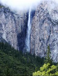
Ribbon Falls
Yosemite Valley, Yosemite National Park
24.1 miles SWStanding at 1612 ft tall, Ribbon Falls is one of the tallest waterfalls in Yosemite Valley and the longest single-drop waterfall in North America. It's visible from El Capitan road as you...
Hike 0.2 mi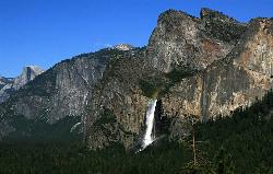
Bridalveil Falls
Yosemite Valley, Yosemite National Park
24.7 miles SWKnown for being the focal point for one of Ansel Adams' most famous photographs, Bridalveil Falls is one of the first waterfalls you see as you enter Yosemite. The path to get there...
Hike 5.5 mi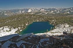
Ostrander Lake
Wawona, California
25.2 miles SWOstrander Lake is a long, 11.4 mile hike just behind Sentinel Dome. Unlike most of Yosemite's summer hikes, the trail to Ostrander Lake is open during the winter for people to ski through....
Hike, Swim

Crystal Lake
Mammoth Lakes, California
25.6 miles SEUnlike many hikes in the Sierra's, Crystal lake can be done as a day hike and as the perfect way to get away for a bit. As hikers make their way to the lake, they will see the monolith Crystal...
Camp, Hike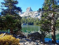
Crystal Crag
Mammoth Lakes, California
25.6 miles SEVisible from all the lakes around, Crystal Crag stands tall and is a popular place to rock climb and go mountaineering. It stands at 10,100 ft in elevation, and includes a North Ridge and a South...
Rock Climb
Volcom Brothers Skatepark
Mammoth Lakes, California
25.7 miles SEthis park looks good thanks to Volcom for the pictures.
Skateboard 0.5 mi
McGurk Meadow
Yosemite National Park
25.8 miles SWMcGurk Meadow is a short, 0.8 mile hike through one of Yosemite's wildflower meadows. The trail is fairly flat, about 100 feet of elevation gain, and it doesn't require too much effort,...
Hike
Hot Creek
Mammoth Lakes, California
28.0 miles SECLOSED. Entering the water is now prohibited at this location. This note came in 2008:"I noticed your report of swimming in Hot Creek near Bishop, Calif. I was there in 2006 and it was closed to...
Swim


