


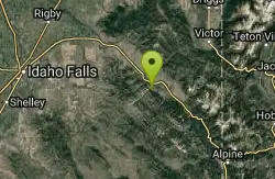
231 Things to do near Heise Rock (AKA Elephant Rock)
first prev 1 2 3 4 5 6 7 8 9 10 next lastShowing results within 50 miles Distance miles of 5191 E Heise Rd, Ririe, ID 83443, USA City, Zip, or Address
Echo/Indian Creek Trail
Swan Valley, Idaho
19.9 miles SEOHV trail. source: fs.usda.gov
Mountain Bike
Horseshoe Canyon
Tetonia, Idaho
20.0 miles EHorseshoe Canyon is one of the closest trail systems to the town of Driggs, Idaho. This network doesn't have a ton of climbing or descending, but the smooth, swooping singletrack with a...
Mountain Bike
Bovine
Driggs, Idaho
20.1 miles EBovine trail is part of a larger system. You can use it to access more trails or make it your end destination from other trailheads. It is a steep climb but returns the favor with a fast downhill....
Mountain Bike
Horseshoe Trails
Driggs, Idaho
20.1 miles EMountain Bike near Driggs, Idaho
Mountain Bike
Fall Creek Falls
Swan Valley, Idaho
20.1 miles SEFalls Campground is located next to the Snake River near beautiful Swan Valley, only 45 miles east of Idaho Falls, Idaho. Mixed growth cottonwood trees provide partial shade, and grassy meadows with...
Camp, Cave, Hike, Kayak, Swim
South Fork Fall Creek Trail
Swan Valley, Idaho
20.2 miles SEOHV trail.
Mountain Bike
Channel Lock
Driggs, Idaho
20.7 miles ETrail is a little over 1 mile uphill. Recommended route up to access the larger Horseshoe canyon trail system. Makes a nice downhill with twists. Gets its name from the deep ruts made from cows....
Mountain Bike
Southbound
Driggs, Idaho
20.7 miles ETrail starts by going up the Channel lock trail. At the top of Channel Lock go right onto the Southbound trail. Trail will loop back to Channel lock which you take back to your car. Trail is...
Mountain Bike
Sharks Belly
Driggs, Idaho
20.7 miles ETrail system can start from Channel lock or Bovine. Channel Lock is an easier climb than Bovine. This description and mileage starts at the Channel Lock trail, forest service boundary marker. Take...
Mountain Bike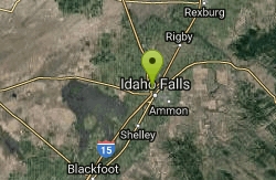
Freeman Park
Idaho Falls, Idaho
20.7 miles SWA couple of creek crossings add to appeal. Snake river borders most of this beautifully maintained course. Good elevation and variety. Public (No Fee)
Disc Golf 1.0-7.5 mi
Idaho Falls Greenbelt
Idaho Falls, Idaho
20.8 miles SWThe Idaho Falls Greenbelt is one of Idaho Falls charms located in the heart of Idaho Falls, next to the historic Idaho Falls downtown. The paved foot-trail is approximately 6 miles around,...
Hike
Monkey Rock
Saint Anthony, Idaho
20.8 miles NCLOSED. PSA: Monkey Rock is no longer open to the public. The owner has posted "No Trespassing" signs and is asking the Fremont County Sheriff's Office to assist with keeping people out of their...
Swim
Rattle Rock / The Gauntlet
Menan, Idaho
20.9 miles NWRattle Rock is a much different arena than the flat or even hilly woods associated with rec ball or wooden scrap barriers like many established fields. You won't find any trees, spools, or straw...
Airsoft, Paintball
Hog Hollow Bridge
Saint Anthony, Idaho
20.9 miles NLess than 1/2 a mile down the road from the Monkey Rock waterfall, Hog Hollow Bridge is a favorite spot for adrenaline junkies to cool off. The place to jump is off the East side of the bridge where...
Dive, Swim
Falls Campground
Victor, Idaho
21.0 miles SEFalls Campground is located next to the Snake River near beautiful Swan Valley, only 45 miles east of Idaho Falls, Idaho. Mixed growth cottonwood trees provide partial shade, and grassy meadows...
Camp
Idaho Falls Skate Park
Idaho Falls, Idaho
21.4 miles SWSkateboard near Idaho Falls, Idaho
Skateboard 1.2 mi

Spooky
Victor, Idaho
22.4 miles ETrail serves as the stem to Red Creek or access to Corral Creek as well as other possibilities in the big hole mountains. Nice fun singletrack to run as an out n back if your time is...
Mountain Bike
Red Creek Via Spooky Trail
Victor, Idaho
22.4 miles ETrail starts on the Spooky trail segment. About 1.2 up you'll see a trail on your left. This is where you will be coming out at. Continue straight. At about 2.6 from the car you'll...
Mountain BikeHenry's Fork Green Way (St. Anthony Green Belt)
Saint Anthony, Idaho
22.5 miles NThis is a great walk along the river. While it is nestled right next to the highway, the closeness and beauty of the river flowing on the other side of the trail more than make up for it. Halfway...
Hike
Twin Creek Trail
Driggs, Idaho
22.7 miles EThe Twin Creek trail is 2.3 miles long. It begins at Trail 6195 and ends at Trail 6219. source: fs.usda.gov
Mountain Bike


