


57 Things to do near Tenaya Lake
first prev 1 2 3 next lastShowing results within 50 miles Distance miles of RGMP+49 Yosemite Valley, CA, USA City, Zip, or Address

May Lake
Yosemite Valley, Yosemite National Park
1.9 miles NWMay lake is a relatively small lake that rests at the base of Mt. Hoffman in Yosemite National Park. One of the park's most scenic lakes, May lake not only gets up close and personal with...
Hike, Swim 0.9-3.2 mi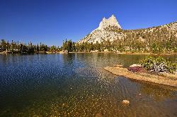
Cathedral Lakes
Wawona, California
2.3 miles EOne of the busiest trails in the Tuloumne Meadows area, the hike to Cathedral Lakes is a gorgeous 7 mile walk to the perfect place to rest and recuperate. While there are several High Sierra...
Hike, Swim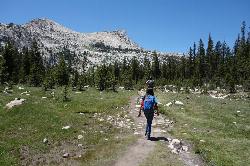
Elizabeth Lake
Wawona, California
5.2 miles EElizabeth Lake is a gorgeous lake tucked underneath the High Sierras in Yosemite. It's about a 4.8 mile hike to reach it, with an elevation gain of 1000 feet. Even though it's not super long,...
Hike, Swim 5.7 mi
Ten Lakes
Tuolumne Meadows, Yosemite National Park
5.7 miles NWA 6.4 mile hike will lead you to three of the Ten Lakes at Ten Lakes Basin. There are three possible trails to take to see this phenomenon. The shortest begins at Yosemite Creek. The other two...
Backpack, Camp, Hike 6.0 mi
Glen Aulin
Wawona, California
5.8 miles NEThis is an 11 mile hike along the Tuolumne River to Glen Aulin. There is a view to take in at every turn on this hike, whether it's the Tuolumne River, Tuolumne Fall, Soda Springs,...
Backpack, Camp, Hike
Glen Aulin
Glen Aulin, California
5.8 miles NEThis trail is a popular route to take in the Yosemite High Country because it is a good introductory hike into the backcountry. At the end of the hike there are several waterfalls as well as a...
Backpack, Camp, Hike, Swim 2.1 mi
Snow Creek Falls
Yosemite Valley, Yosemite National Park
6.1 miles SWSnow Creek is one of the more difficult waterfalls to find in the valley, but in the spring and summer months, the elusive waterfall can be seen from the Mirror Lake Trail, a 5 mile loop around...
Backpack, Hike 1.9 mi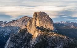
Half Dome
Yosemite Valley, Yosemite National Park
6.6 miles SWHalf Dome is the most popular and difficult hike in Yosemite Valley. The trail is about 14 miles long with an elevation gain of 4800 feet. There are cables to help you scale up to the summit once you...
Hike

Tuolumne Meadows
Tuolumne County, California
7.1 miles NEA beautiful alpine meadow found in the upper Sierra Nevada Mountains. Open during the summer, this meadow offers excellent views of nearby granite domes and mountains. There is a roadway through...
Camp, Hike 4.0 mi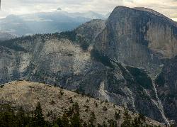
North Dome
Yosemite Valley, Yosemite National Park
7.4 miles SWNorth Dome is a strenuous 10.4 mile hike that gives visitors a close up view straight at Half Dome from across the valley. It also has a unique view of Clouds Rest peak. Because the hike...
Backpack, Hike
Mirror Lake
Yosemite Valley, Yosemite National Park
7.5 miles SWMirror Lake is a seasonal lake situated in a secluded corner of the beautiful Yosemite Valley. The lake sits at the base of Half Dome and allows a different perspective of the famous monolith....
Backpack, Hike, Swim 0.8-4.1 mi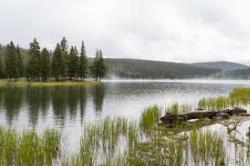
Dog Lake and Lembert Dome
Yosemite Valley, CA
7.9 miles NEThe hike to Dog Lake is often paired with the hike to Lembert Dome, because the two are so close in proximity. Each hike by itself is 2.8 miles round trip, but Lembert Dome has an elevation gain of...
Hike, Swim
Devil's Bathtub
Yosemite Valley, California
8.3 miles SWDevil's Bathtub is one of those destinations that's a little more off the beaten path of Yosemite tourists. It's just above the Majestic Yosemite (AKA Ahwanhee Hotel). Earlier in the...
Swim 0.7 mi
Lukens Lake
Tuolumne Meadows, Yosemite National Park
8.3 miles WLukens Lake is a small lake in the White Wolf area of Yosemite National Park. The hike is a short, 1.6 mile walk through a forest to the secluded lake surrounded by trees and a small...
Hike, Swim 2.9 mi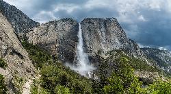
Upper Yosemite Falls
Yosemite Valley, Yosemite National Park
8.5 miles SWYosemite Falls is the tallest waterfall in North America, standing at 2,425 feet. It's made up of Upper Yosemite Falls, Lower Yosemite Falls, and the middle cascades. Lower Yosemite Falls...
Hike 1.9-2.9 mi
Mist Trail
Yosemite National Park
8.6 miles SWThe mist trail is a small breakoff from the John Muir Trail through Yosemite National Park. It's called the mist trail because of the heavy amount of mist that hikers walk through as Vernal and...
Backpack, Hike
Merced River
Yosemite Valley, Yosemite National Park
9.1 miles SWThe main fork of Merced River at Yosemite National Park is a perfect place to fish, swim, raft, and even pan for gold. The river circles around the center of Yosemite Valley, and almost every...
Camp, Swim, Whitewater 3.6 mi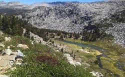
Lyell Canyon
Wawona, California
9.1 miles ELyell Canyon is a breezy, 8 mile hike through the Tuloumne Meadows of Yosemite. While it is a little bit of a longer hike, the total elevation gain is about 200 feet, making it pretty flat and...
Hike 0.7 mi
Cook's Meadow Loop
Yosemite Valley, Yosemite National Park
9.3 miles SWCook's Meadow Loop is a shorter, smaller hike inside Sentinel Meadow. Cook's Meadow Loop is just under a mile and takes about 45 minutes to complete, depending on how long you stop at each...
Hike 0.3 mi
Glacier Point
Yosemite National Park
9.4 miles SWLocated in Yosemite National Park, Glacier Point gives a birds-eye-view of the park you can't find anywhere else. It can be accessed by both hiking and driving through the park, though the roads...
Hike


