


238 Things to do near Yellowstone Branch Line Trail
first prev 1 2 3 4 5 6 7 8 9 10 next lastShowing results within 50 miles Distance miles of Yellowstone Branch Line Trail, Ashton, ID 83420, USA City, Zip, or Address

Cave Falls of Yellowstone
Ashton, Idaho
15.6 miles EThis campgrond is situated on the banks of Fall River in Wyoming along the south border of Yellowstone National Park. Cave Falls Campground has 23 single site units and a terrific area for...
Camp, Hike 0.6-4.7 mi
Harriman State Park
Island Park, Idaho
15.8 miles NWHarriman State Park is found 38 miles from Yellowstone along Henry's Fork. This 11,000-acre wildlife refuge is open year round for most activities. In addition to having beautiful scenery and...
Cross-country Ski, Hike, Horseback, Mountain Bike, Snowshoe
Sand Creek Frenzy
Ashton, Idaho
16.8 miles WThere are some woods back there and it is secluded. There are many places you can play just watch out for campers.
Paintball
Loon Lake
Ashton, Idaho
17.9 miles ECamp, Kayak, and Swim near Ashton, Idaho
Camp, Kayak, Swim 15.9-16.6 mi
Union Falls & Ouzel Pool
Grant Village, Yellowstone National Park
18.2 miles EBackpack, Hike, Hot Springs, and Swim near Grant Village, Yellowstone National Park
Backpack, Hike, Hot Springs, Swim 1.1 mi
Fish Lake
Ashton, Idaho
18.2 miles EHike near Ashton, Idaho
Hike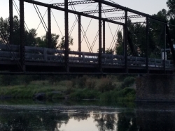
Fun Farm Bridge
Saint Anthony, Idaho
18.2 miles SWAlso known as the Funny Farm Bridge, this is an excellent place for bridge jumping. You can jump from the road level, the top of the bridge, or swing from the bars below. Just be watchful of cars...
Dive, Swim
Hog Hollow Bridge
Saint Anthony, Idaho
19.6 miles SWLess than 1/2 a mile down the road from the Monkey Rock waterfall, Hog Hollow Bridge is a favorite spot for adrenaline junkies to cool off. The place to jump is off the East side of the bridge where...
Dive, Swim
Badger Creek
Tetonia, Idaho
19.6 miles SEBadger Creek is a stream located just 13.6 miles from Ashton, in Teton County, in the state of Idaho, United States, near France, ID. Whether you’re spinning, baitcasting or fly fishing your...
Camp, Cross-country Ski, Hike, Mountain Bike, Rock Climb
Monkey Rock
Saint Anthony, Idaho
19.8 miles SWCLOSED. PSA: Monkey Rock is no longer open to the public. The owner has posted "No Trespassing" signs and is asking the Fremont County Sheriff's Office to assist with keeping people out of their...
Swim 5.8 mi
Box Canyon Trail
Island Park, Idaho
20.7 miles NVarious species of tress and wildflowers can be seen on the trail, as well as songbirds, waterfowl and occasional wildlife. The trail is open for the following uses: Motorcycle Trail Riding, Off...
Hike, Mountain Bike
Box Canyon Island Park
Island Park, Idaho
20.8 miles NThe Box Canyon Campground is situated on the canyon rim above the Henry's Fork of the Snake River. There are 16 single and 2 double units, each having tent and camper pads, fire rings, grills...
Canoe
St. Anthony Sandbar
Saint Anthony, Idaho
21.2 miles SWCLOSED. //// Sand Bar Update //// ***As of 27 June 2019 *** The Sand Bar is still closed to ALL swimming, please do not cross the boundary line. We are closely monitoring the river flows...
Dive, Swim 0.9 mi
Buffalo River Campground
Island Park, Idaho
21.4 miles NThe float here is nice and easy. It's a great early season float. Later in the season the shallow spots will force you to walk a good chunk of the float. The water is super clear and often pretty...
Camp, Canoe, Kayak, SwimHenry's Fork Green Way (St. Anthony Green Belt)
Saint Anthony, Idaho
21.9 miles SWThis is a great walk along the river. While it is nestled right next to the highway, the closeness and beauty of the river flowing on the other side of the trail more than make up for it. Halfway...
Hike 1.9 mi

Terraced Falls
Grant Village, Yellowstone National Park
23.0 miles E3.6 mile easy out and back trail. 430 ft Elevation gain. The trailhead is off Ashton-Flagg Ranch Road along Yellowstone's South border. Ashton-Flagg Ranch Road is closed during the winter.
Hike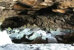
Civil Defense Caves
Rexburg, Idaho
23.1 miles WThe caves are large lava tubes. The name comes from the cold war era when they were anticipated as a safe area in the case of an attack. The entrance is pretty bouldery and does require a small...
Cave
Wright Creek Trail
Tetonia, Idaho
23.4 miles SOpen to MTB, horseback riding, snowshoeing, and hiking. source: fs.usda.gov
Mountain Bike
Marshall's
Saint Anthony, Idaho
23.5 miles SWMarshall's Wave is located on the North Fork of the Teton River, where the Teton River splits into the north and south forks. The wave is created by a headgate and is best at flows above 600...
Kayak 0.6 mi
Packsaddle Lake
Tetonia, Idaho
24.0 miles SPacksaddle is one of the less well known lakes/trails in the area. If you've got a good offroad vehicle, you can probably make it all the way to the end of the road, otherwise, it's just an...
Dive, Hike, Mountain Bike, Snowshoe, Swim


