


Packsaddle Lake
Tetonia, Idaho

| Address: | Packsaddle Lake Rd, Tetonia, ID 83452, USA |
| GPS: |
43°46'26.5"N 111°20'20.3"W Maps | Directions |
| State: | Idaho |
| Trail Length: | 5.00 miles |
| MTB Difficulty: | Beginner |
| Trail Type: | Out & Back |
| MTB Trail Type: | Fire Road |
| Hike Difficulty: | Intermediate |
| Trails/Routes: | 0.6 mi |
Lakes Rivers Trails Wildflowers
Dive, Hike, Mountain Bike, Snowshoe, and Swim
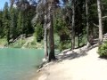
Packsaddle Lake is a little-known gem tucked into the Big Hole Mountains west of Tetonia, Idaho — a small, cold, tree-ringed mountain lake with a rope swing, a hidden-away feel, and glimpses of the Tetons on the way in. It sees a fraction of the crowds of the more famous Teton-side lakes, which is a big part of its charm, but earning that solitude takes a rough drive and a steep little hike.
Getting there is the crux. The access road is genuinely rough — a high-clearance or four-wheel-drive vehicle is strongly recommended, and drivers of cars and minivans report needing some creative maneuvering to pick their way up. About 0.4 miles below the trailhead the road takes a steep, washed-out turn, and there are good pull-offs where you can simply park and walk the rest. From the upper trailhead it's a short but steep descent of around 300 feet in under half a mile down to the water; you'll spot the lake from the top of the trail, and switchbacks make the grade manageable.
At the lake you'll find a small camp area on the eastern shore and a rope swing out over the water — swing out far enough, since the lake shallows and drops off quickly near the edge, and the water is bracingly cold. It's a fun spot to swim, float (bring an inflatable if you can), picnic, and cool off after the hike in. Mountain bikers can also reach the lake by a longer, climbing singletrack from the lower trailhead that serves up beautiful Teton views before dropping to the water.
A few seasonal notes: the mosquitoes can be fierce up top in early summer (they ease off down by the lake), so bring repellent, and water levels drop as the season goes on. Snow lingers on the high road into early summer and returns in fall — more than one group has gotten a vehicle stuck in an early- or late-season snow squall up here.
The Big Hole Mountains that cradle the lake are a quieter, lower range just west of the Tetons, laced with trails and dotted with small lakes — a locals' playground for hiking, mountain biking, and hunting that rarely feels crowded. Packsaddle is one of its little treasures: a place to swing off the rope, float away an afternoon, cast for the occasional trout, or pitch a tent for a low-key overnight under the stars. On the drive and hike in, the reward is those signature Teton views rising to the east over the intervening ridges.
Come prepared for backcountry conditions: there are no facilities, so carry plenty of water, sun protection, and everything you'll need, and pack out all your trash. For those willing to brave the road, Packsaddle Lake is a rewarding, off-the-radar escape in the quiet Big Hole Mountains.
More Information
Packsaddle Lake
Packsaddle Lake is a singletrack mountain bike trail in Tetonia, Idaho. View maps, videos, photos, and reviews of Packsaddle Lake bike trail in Tetonia.
http://www.singletracks.com/bike-trails/packsaddle-lake/Packsaddle Lake Hike - RexburgFun
Packsaddle Lake Hike, roughly half an hour east of Rexburg, is beautiful and great for a quick day hike.
https://rexburgfun.com/packsaddle-lake-hike/Packsaddle Lake... Without Packed Saddles
The weather in Southeastern Idaho has finally turned. And by turned, I think it turned straight from Summer to Winter! Last weekend it was i…
http://sportsmanjoe.blogspot.com/2009/10/packsaddle-lake-without-packed-saddles.htmlNever modify trail features. Ride trails when they're dry enough that you won't leave ruts. Speak up when you see others on the trail and always yield to hikers, horses, and others coming uphill. Always ride on the established trail.
Read MoreBe courteous, informed, and prepared. Read trailhead guidelines, stay on the trail, and don't feed the wildlife.
Read More- Plan Ahead and Prepare
- Travel & camp on durable surfaces
- Dispose of waste properly
- Leave what you find
- Minimize campfire impacts
- Respect wildlife
- Be considerate of other visitors
Directions
From Tetonia, Idaho
- Head south on S Main St toward Perry Ave (0.2 mi)
- Turn right onto N 3000 W (2.1 mi)
- Turn right onto W 4000 N (6.7 mi)
- Continue onto Packsaddle Rd (1.2 mi)
- Continue onto Packsaddle Lake Rd (1.8 mi)
- Turn left to stay on Packsaddle Lake Rd (0.5 mi)
If you're okay driving through 1.5 feet of murky water
- Head East on Highway 33 towards Driggs (24.4 mi from Hwy 20)
- Turn RIGHT onto Hoopes Road
- As you come to the edge of the woods, keep LEFT at the fork to stay on Hoopes Road.
- Immediately after the turn, the road will likely be flooded. If you plan to drive through it, you may want to make sure you're not going to hit any debris
- You'll come to a 'T' in the road. Turn RIGHT onto Packsaddle Lake Road
- Follow Packsaddle Lake Road for 1.8 miles
- At the fork, turn left (either on foot or by car). The road from here is pretty steep and can be quite difficult
- At the top of the hill, follow the trail to the left down the hill. You should be able to see bits of the lake pretty soon
Otherwise
- Head East on Highway 33 towards Driggs (24.4 mi from Hwy 20)
- Turn right onto N 8000 W after passing Rim River Ranch
- After 3.9 miles, turn right onto W 4000 N
- Continue on Packsaddle Lake Road for 3 miles
- At the fork, turn left (either on foot or by car). The road from here is pretty steep and can be quite difficult
- At the top of the hill, follow the trail to the left down the hill. You should be able to see bits of the lake pretty soon


")


Other Mountain Bike Trails, Swimming Holes, Hiking Trails, Snowshoe Trails, and Diving Platforms Nearby

Wright Creek Trail
Tetonia, Idaho
2.4 miles WA multi-use trail near Tetonia, Idaho open for mountain biking, horseback riding, snowshoeing, and hiking in Targhee National Forest terrain.
Mountain Bike
Probation And Burg Bumper
Tetonia, Idaho
2.6 miles SEThe steepest downhill in the Tetonia area — a mile of bridges and log jumps on Probation, with the climbing Burg portion returning you to a 5-way junction with options to extend your ride.
Mountain Bike
North Mahogany Trail #220
Tetonia, Idaho
4.2 miles SEA multi-use trail open to motorbikes, mountain bikes, horses, and hikers — often accessed via South Horseshoe Trail (219) and paired with Nickerson Grove Trail (195) for a great loop.
Mountain Bike
Horseshoe Canyon
Tetonia, Idaho
4.2 miles SESmooth, swooping singletrack close to Driggs with varied route options, low elevation, and a dry climate that makes it one of the first trails to open each season.
Mountain Bike
Horseshoe Trails
Driggs, Idaho
4.3 miles SEMountain Bike near Driggs, Idaho
Mountain Bike
Bovine
Driggs, Idaho
4.3 miles SEA steep climb that pays you back with a fast, flowing downhill through smooth dirt and well-maintained berms — one of the first trails to open in spring and last to close in fall.
Mountain Bike
Sharks Belly
Driggs, Idaho
4.4 miles SEA loop network connecting Channel Lock, Sodbusters, Cody's Loop, and Shark's Belly through pine-needle-carpeted singletrack in the Tetons — a smooth, secluded, tree-lined ride.
Mountain Bike
Channel Lock
Driggs, Idaho
4.4 miles SEA short, smooth 1-mile access trail to the Horseshoe Canyon trail system near Driggs — fast and fun going down, with aspen stands, sagebrush, and 13 bermed turns.
Mountain Bike
Southbound
Driggs, Idaho
4.5 miles SEAn open sagebrush hillside MTB trail with sweeping Teton Range views, a small tree section, and a mostly XC up-and-down feel — one of the first trails to dry out in spring.
Mountain Bike
Twin Creek Trail
Driggs, Idaho
7.2 miles SEA 2.3-mile mountain bike and trail connector near Driggs running from Trail 6195 to Trail 6219 in the Idaho backcountry.
Mountain Bike
Thousand Springs Trail
Driggs, Idaho
8.2 miles SWA singletrack trail beginning at Moody Swamp trailhead and ending at the Prospect Peak Trail junction in Idaho's Teton-area national forest.
Mountain Bike
Big Hole Crest Trail
Driggs, Idaho
9.5 miles SEA tough advanced mountain bike ride near Driggs with lots of climbing and descending — the north and south singletrack ends are stellar, while the middle is less maintained and moto-torn.
Mountain Bike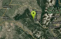
Henderson Canyon
Victor, Idaho
11.2 miles SEA dirt road and doubletrack trail in Victor, Idaho with numerous singletrack branches — some more traveled than others — winding through scenic terrain in Henderson Canyon.
Mountain Bike 3.9 mi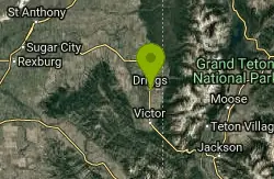
Three Wookie Trail
Driggs, Idaho
11.9 miles EMountain Bike near Driggs, Idaho
Mountain Bike 0.1-0.2 mi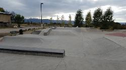
Driggs Bike and Skate Park
Driggs, Idaho
12.5 miles EA great concrete skatepark with a deep multi-bowl setup alongside a small mountain bike park with about half a mile of singletrack, dirt jumps, and a large wooden berm.
Mountain Bike, Skateboard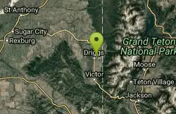
Driggs Nordic Trail
Driggs, Idaho
12.5 miles EA 3.1-mile groomed Nordic track in Driggs, perfect for cross-country skiing — check the online grooming report before heading out.
Cross-country Ski, Snowshoe
Burns Canyon
Ririe, Idaho
13.4 miles SWHike and Mountain Bike near Ririe, Idaho
Hike, Mountain Bike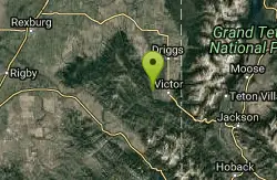
Rocky Peak Via Spooky Trail
Victor, Idaho
13.5 miles SEA rugged mountain bike loop near Victor, Idaho with steep rocky climbs, a crest-level Grand Teton view, and an insanely fast rocky descent on Rocky Peak Trail.
Mountain Bike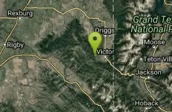
Grove Creek to Drake Creek
Victor, Idaho
13.5 miles SEThe Grove Creek–Drake Creek loop climbs into the Big Hole Mountains for Teton views and a fast, technical Drake Creek descent.
Mountain Bike 0.6-5.5 mi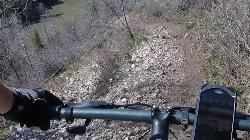
Old Ranger
Ririe, Idaho
13.5 miles SWA diverse, challenging singletrack on a southern-exposure ridge above the Snake River — great for early or late season riding when other trails are still snow-covered or muddy.
Mountain BikeNearby Campsites

Moody Meadows
Driggs, Idaho
9.0 miles SWGood place for kids, they can ride bikes in the meadow, play in the stream, and camping is off of the road. Hiking, motorbiking, and horseback riding trails are abundant in the area.
Camp 0.5-3.5 mi
Webster's Dam
Ririe, Idaho
14.0 miles WAn abandoned dam in Moody Creek canyon where sediment split the stream into two beautiful 15-foot waterfalls — stunning in spring runoff and blazing with fall colors.
Camp, Hike, Mountain Bike
Big Hole Dispersed Campsites
Ririe, Idaho
15.1 miles SWA network of dispersed campsites with fire rings in the Big Hole mountains above Kelly Canyon — first come, first served, no reservations, and Leave No Trace principles are essential.
Camp
Pine Creek Campground
Victor, Idaho
15.4 miles SEThe Pine Creek Campground has 10 single units and has restrooms.
Camp
Table Rock Campground
Ririe, Idaho
16.0 miles SWA campground in Caribou-Targhee National Forest — part of a 3-million-acre stretch from Montana to the Utah and Wyoming borders — with access to the Curlew National Grassland.
Camp
Darby Canyon Camping
Alta, Wyoming
17.3 miles SEDispersed campsites with fire lays in scenic Darby Canyon — no official campground, just established spots in Wyoming wilderness. Leave No Trace and use existing rings only.
Camp
Wolf Flats Recreation Area
Ririe, Idaho
18.2 miles SWWolf Flats is a completely free, dispersed, undeveloped camping area with 25 locations to camp. Some areas are large enough to accommodate groups of 50 people.
Camp
Paramount Wall / Blanche Rock
Ririe, Idaho
18.3 miles SWA sport climbing wall above the road near Ririe with great exposure, afternoon shade, and well-loved 5.9–5.10 lines — most routes work with a 50-meter rope, established by Chuck Oddette and crew.
Camp, Horseback, Rock Climb
Kelly Island Campground
Ririe, Idaho
19.2 miles SWA BLM campground with 14 family sites and 1 group site for RVs or tents, open May through September — vault toilets, pets welcome, and rates from $5–$20 per night.
Camp
Reunion Flat Campground
Alta, Wyoming
19.4 miles ECamp near Alta, Wyoming
Camp
Mike Harris Campground
Victor, Idaho
20.2 miles SEA scenic mountain campground at 6,200 feet along Teton Pass just 5 miles from Victor, Idaho — a peaceful base for fishing, trail exploring, and sightseeing in the Teton region.
Camp
Teton Canyon Campground
Alta, Wyoming
21.0 miles ETeton Canyon Campground is the gateway to Alaska Basin, Table Rock, and the Teton Crest Trail — each site stocked with a picnic table, fire ring, and bear box.
Camp 3.8-6.4 mi
Table Rock / Table Mountain
Driggs, Idaho
21.1 miles EA big climb to 11,300 feet for arguably the finest view of the Grand Tetons — pick the steep Face or the gradual Huckleberry trail.
Camp, Hike
Twin Bridges Park
Rexburg, Idaho
22.4 miles WA 27-acre Snake River park between two bridges near Rexburg with shaded campsites, fire pits, pavilions, a playground, and BLM ground for hiking and hunting on three sides.
Camp, Canoe
Porcupine Creek
Ashton, Idaho
22.5 miles NA backcountry hunting, fishing, camping, and swimming spot in Targhee National Forest, surrounded by forests, meadows, a creek, and unmarked trails — bear country, so pack and store food carefully.
Camp, Swim
Fall Creek Falls
Swan Valley, Idaho
23.1 miles SA shaded Snake River campground near Swan Valley with abundant wildlife, great trout fishing, and Fall Creek Falls a quarter-mile away.
Camp, Cave, Hike, Kayak, Swim 0.2-0.5 mi
Eagle Park
Rexburg, Idaho
23.2 miles WA cottonwood forest park inside Rexburg city limits with campsites, fishing, a dog park, mountain biking on easy and moderate loops, and rock-throwing by the river.
Camp, Hike, Mountain Bike, Sled
Falls Campground
Victor, Idaho
23.6 miles SA Snake River campground near Swan Valley with cottonwood shade, abundant wildlife — eagles, osprey, moose, and deer — and Fall Creek Falls just a quarter mile away; Palisades Reservoir is 20 miles out.
Camp
Warm River Campground
Ashton, Idaho
24.0 miles NSlow-moving warm water and willow-lined banks make this campground a perfect spot for tubing, trout fishing, and peaceful mountain biking at 5,200 ft elevation.
Camp
Sheep Falls on Fall River
Ashton, Idaho
24.5 miles NEA local gem off Cave Falls Road where the river splits into multiple falls tumbling over each other — primitive campsites and beautiful views make it a great picnic stop.
Camp


