


Marshall's
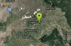
Saint Anthony, Idaho
Kayak
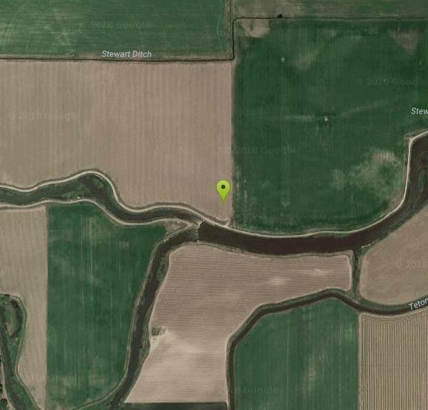
Marshall's Wave is located on the North Fork of the Teton River, where the Teton River splits into the north and south forks. The wave is created by a headgate and is best at flows above 600 cfs.
More Information
- Plan Ahead and Prepare
- Travel & camp on durable surfaces
- Dispose of waste properly
- Leave what you find
- Minimize campfire impacts
- Respect wildlife
- Be considerate of other visitors
Directions
From Saint Anthony, Idaho
- Head west on E Main St toward S Bridge St (79 ft)
- Turn left at the 1st cross street onto S Bridge St (0.4 mi)
- Turn left onto E 6th S (0.2 mi)
- Keep right to continue on S 3rd E (0.4 mi)
- Continue onto Teton Hwy (4.8 mi)
- Turn left onto Main St (364 ft)
- Turn right onto 3rd St W (39 ft)
- Turn left at the 1st cross street onto Main St (0.7 mi)
- Turn left onto 2nd St E (0.3 mi)
- Turn right onto 2nd St N (0.2 mi)
- 2nd St N turns slightly left and becomes N 2500 E (0.5 mi)
- Turn left onto E 100 N (456 ft)
Marshall's Wave is located on the North Fork of the Teton River, where the Teton River splits into the north and south forks.
Other Kayaking Areas Nearby
Sucky Courtney's
Saint Anthony, Idaho
1.3 miles WMarshall's Wave on the North Fork of the Teton River kicks up a friendly surf wave for beginners, with a generous eddy on river left at flows above 600 cfs.
Kayak
Lorenzo Boat Ramp
Rigby, Idaho
15.4 miles SWHike and Kayak near Rigby, Idaho
Hike, Kayak
Rigby Wave-45th Wave
Rigby, Idaho
17.0 miles SWKayak near Rigby, Idaho
Kayak
Jefferson County Lake (AKA Rigby Lake)
Rigby, Idaho
18.0 miles SWSandy beaches, two floating docks with a slide, volleyball, playgrounds, and a safe swim zone — Jefferson County Lake is eastern Idaho's go-to summer swimming spot.
Camp, Canoe, Dive, Kayak, Sled, Swim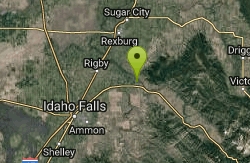
Big Feeder
Ririe, Idaho
18.5 miles SKayak near Ririe, Idaho
Kayak
Mesa Falls
Ashton, Idaho
26.2 miles NEUpper Mesa Falls drops 114 feet and spans 300 feet across the Henrys Fork — just 0.2 miles of paved walkway from the parking lot, with platforms, handrails, and morning rainbow mist.
Cross-country Ski, Hike, Kayak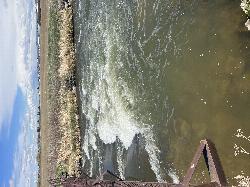
Double Tap wave feature
Idaho Falls, Idaho
30.9 miles SWTwo back-to-back whitewater features in an Idaho Falls irrigation canal — an open dam wave and a lava-shelf drop — give kayakers a quick urban freestyle session.
Canoe, Kayak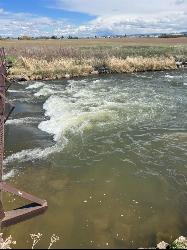
The Junk Field Wave
Idaho Falls, Idaho
30.9 miles SWKayak near Idaho Falls, Idaho
Kayak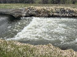
Street kid rapid
Idaho Falls, Idaho
33.3 miles SWA short rock-garden rapid in an urban canal gives kayakers a quick thrill and a low-stakes spot to test a new boat — wear a PFD in spring high water.
Canoe, Kayak
Fall Creek Falls
Swan Valley, Idaho
34.8 miles SEA shaded Snake River campground near Swan Valley with abundant wildlife, great trout fishing, and Fall Creek Falls a quarter-mile away.
Camp, Cave, Hike, Kayak, Swim 17.5 mi
Tear Drop Lake
Ashton, Idaho
35.0 miles NEA small, lively lake in the Targhee forest for kayaking, swimming, and an easy loop trail — family fun with primitive lakeside camping.
Camp, Canoe, Hike, Kayak, Mountain Bike, Swim
Loon Lake
Ashton, Idaho
38.6 miles NECamp, Kayak, and Swim near Ashton, Idaho
Camp, Kayak, Swim 0.9 mi
Buffalo River Campground
Island Park, Idaho
39.6 miles NAn easy, clear, and often warm float on the Buffalo River near Island Park, with slow enough current to paddle back upstream in a canoe or kayak after your run.
Camp, Canoe, Kayak, Swim
Calamity Campground
Irwin, Idaho
45.6 miles SEA wooded Palisades Reservoir campground 55 miles east of Idaho Falls with clean blue water for swimming, boating, water skiing, and fishing — plus miles of ATV routes.
Camp, Canoe, Hike, Kayak, Mountain Bike, Swim 3.6 mi
String Lake
Alta, Wyoming
47.4 miles EA shallow, warm lake connecting Jenny and Leigh Lakes at the base of the Tetons — the clear water lets you see the bottom from a kayak, wade easily with kids, and access wilder open water beyond.
Canoe, Hike, Kayak, Swim 0.1-7.3 mi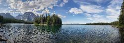
Leigh Lake
Alta, Wyoming
47.4 miles ETucked beneath Mount Moran and just a mile from the String Lake trailhead, Leigh Lake rewards with majestic serenity, shoreline views of Boulder Island, and calm waters perfect for kayaking or canoeing.
Backpack, Canoe, Hike, Kayak 6.9 mi
Big Elk Creek
Irwin, Idaho
48.5 miles SEA versatile campground on a small dammed lake with fishing, kayaking, hiking and backpacking into the Caribou-Targhee National Forest, and stunning fall Aspen and Douglas-Fir colors on the Big Elk Creek Trail.
Backpack, Camp, Canoe, Hike, Horseback, KayakNearby Campsites

Eagle Park
Rexburg, Idaho
7.7 miles SWA cottonwood forest park inside Rexburg city limits with campsites, fishing, a dog park, mountain biking on easy and moderate loops, and rock-throwing by the river.
Camp, Hike, Mountain Bike, Sled 0.8-1.3 mi
Warm Slough Campground
Rexburg, Idaho
10.1 miles WA popular river campground with two boat ramps and an easy, slow-moving inner tube float — the take-out is 1,000 feet from the put-in, making multiple runs a breeze.
Airsoft, Camp, Canoe
Beaver Dick Park
Rexburg, Idaho
12.9 miles SWA 9.5-acre Snake River park near Rexburg with fire pits, pavilions, fishing, boating, swimming, and a rich history tied to legendary frontiersman Beaver Dick Leigh.
Camp, Canoe, Disc Golf, Swim 0.5-3.5 mi
Webster's Dam
Ririe, Idaho
14.4 miles SAn abandoned dam in Moody Creek canyon where sediment split the stream into two beautiful 15-foot waterfalls — stunning in spring runoff and blazing with fall colors.
Camp, Hike, Mountain Bike
Big Hole Dispersed Campsites
Ririe, Idaho
15.9 miles SA network of dispersed campsites with fire rings in the Big Hole mountains above Kelly Canyon — first come, first served, no reservations, and Leave No Trace principles are essential.
Camp
Twin Bridges Park
Rexburg, Idaho
16.3 miles SA 27-acre Snake River park between two bridges near Rexburg with shaded campsites, fire pits, pavilions, a playground, and BLM ground for hiking and hunting on three sides.
Camp, Canoe 0.6-2.0 mi
North Menan Butte ('R' Mountain)
Menan, Idaho
17.8 miles SWA volcanic butte locals call R Mountain, with a paved trailhead, chain handrails near the top, informational signs at the rim, and views of Rexburg and the Snake River.
Camp, Cave, Hike
Paramount Wall / Blanche Rock
Ririe, Idaho
18.0 miles SA sport climbing wall above the road near Ririe with great exposure, afternoon shade, and well-loved 5.9–5.10 lines — most routes work with a 50-meter rope, established by Chuck Oddette and crew.
Camp, Horseback, Rock Climb
Jefferson County Lake (AKA Rigby Lake)
Rigby, Idaho
18.0 miles SWSandy beaches, two floating docks with a slide, volleyball, playgrounds, and a safe swim zone — Jefferson County Lake is eastern Idaho's go-to summer swimming spot.
Camp, Canoe, Dive, Kayak, Sled, Swim
Moody Meadows
Driggs, Idaho
18.2 miles SEGood place for kids, they can ride bikes in the meadow, play in the stream, and camping is off of the road. Hiking, motorbiking, and horseback riding trails are abundant in the area.
Camp
Table Rock Campground
Ririe, Idaho
18.9 miles SA campground in Caribou-Targhee National Forest — part of a 3-million-acre stretch from Montana to the Utah and Wyoming borders — with access to the Curlew National Grassland.
Camp
Kelly Island Campground
Ririe, Idaho
19.0 miles SA BLM campground with 14 family sites and 1 group site for RVs or tents, open May through September — vault toilets, pets welcome, and rates from $5–$20 per night.
Camp
Wolf Flats Recreation Area
Ririe, Idaho
20.9 miles SWolf Flats is a completely free, dispersed, undeveloped camping area with 25 locations to camp. Some areas are large enough to accommodate groups of 50 people.
Camp
Warm River Campground
Ashton, Idaho
23.6 miles NESlow-moving warm water and willow-lined banks make this campground a perfect spot for tubing, trout fishing, and peaceful mountain biking at 5,200 ft elevation.
Camp 0.3-0.6 mi
Bear Gulch
Ashton, Idaho
25.8 miles NEAn abandoned ski hill from 1969 with overgrown runs that still deliver great sledding — the lower run is fast and winding all the way down to the old ski lift.
Camp, Cross-country Ski, Hike, Sled
Porcupine Creek
Ashton, Idaho
25.8 miles NEA backcountry hunting, fishing, camping, and swimming spot in Targhee National Forest, surrounded by forests, meadows, a creek, and unmarked trails — bear country, so pack and store food carefully.
Camp, Swim
Pine Butte / The Caldera
St. Anthony, Idaho
26.4 miles NAn old volcano in the Idaho desert that feels like stepping into a mountain forest — pine-covered hillsides, a meadow ringed by aspen and boulders, and a quarter-mile easy trail to the caldera floor.
Camp, Hike, Horseback
Sheep Falls on Fall River
Ashton, Idaho
31.3 miles NEA local gem off Cave Falls Road where the river splits into multiple falls tumbling over each other — primitive campsites and beautiful views make it a great picnic stop.
Camp
Pine Creek Campground
Victor, Idaho
32.3 miles SEThe Pine Creek Campground has 10 single units and has restrooms.
Camp
Horseshoe Lake
Ashton, Idaho
33.5 miles NEA lily-pad-dotted lake hidden in the Targhee National Forest with a gradual beach entry perfect for wading, a floating dock for jumping, and no motorized boats.
Camp, Canoe, Dive, Swim


