


Refine Search
- hike 7
- swim 4
- cave 2
- mountain bike 2
- horseback 2
- cross-country ski 2
- snowshoe 2
- camp 2
- kayak 1
- backpack 1
- sled 1
- dive 1
10 locations
Add Location

 Full Listing
Show more
Cave
Last visited on 23 Sep 2017
Full Listing
Show more
Cave
Last visited on 23 Sep 2017
 Full Listing
Show more
Camp, Hike, Horseback, Swim
Last visited on 29 Aug 2017
Full Listing
Show more
Camp, Hike, Horseback, Swim
Last visited on 29 Aug 2017
 Full Listing
Show more
Hike, Swim
Last visited on 26 Dec 2016
Full Listing
Show more
Hike, Swim
Last visited on 26 Dec 2016
 Full Listing
Show more
Sled
Last visited on 30 Jul 2016
Full Listing
Show more
Sled
Last visited on 30 Jul 2016
 Full Listing
Show more
Cross-country Ski, Hike, Kayak
Last visited on 28 Jun 2014
Full Listing
Show more
Cross-country Ski, Hike, Kayak
Last visited on 28 Jun 2014
Monkey Rock
Saint Anthony, Idaho
4.1 miles SE of Saint Anthony, IdahoCLOSED. PSA: Monkey Rock is no longer open to the public. The owner has posted "No Trespassing" signs and is asking the Fremont County Sheriff's Office to assist with keeping people out of their private property. We would like to remind those who may choose to ignore the "No Trespassing" signs that trespassing is a misdemeanor and will not be tolerated.
Full Listing
Show more
Swim
Last visited on 29 Oct 2017
Monkey Rock features a beautiful waterfall you can wade right up to during the summer. Just under the waterfall is a great spot to wade around in or even some shallow swimming pretty good for small children. Maybe you just want to take advantage of the great bank to bask in the summer sun. The water temperature is fairly cool, which by no means is unwelcomed during the hot summer months. You'll get used to the water fairly quickly once you're in. The waterfall is a fun feature at Monkey Rock, not to mention a popular engagement photo backdrop. The name "Monkey Rock" is derived from the "monkeys" who jump off the rocks at the top of the falls to the pool below. Though not a great height, it's important to be careful and only jump into areas clear of rocks and other hazards and where the water is deep enough that you won't hit bottom when you jump. There really isn't a safe spot to jump from the falls as it doesn't usually get more than 5 feet deep.
The real jumping location is off the Hog Hollow Bridge up the road from the waterfall.
PLEASE NOTE: On the roads leading to Monkey Rock, the speed limit is 35 mph for the last mile. There are kids, cows, horses, and dogs along that road and many people tend to speed going to and from Monkey Rock. Please slow down and stay safe.
0.6 mi
 Full Listing
Show more
Dive, Hike, Mountain Bike, Snowshoe, Swim
Last visited on 21 Oct 2017
Full Listing
Show more
Dive, Hike, Mountain Bike, Snowshoe, Swim
Last visited on 21 Oct 2017
Packsaddle Lake
Tetonia, Idaho
9.3 miles W of Tetonia, IdahoPacksaddle Lake is a little-known gem tucked into the Big Hole Mountains west of Tetonia, Idaho — a small, cold, tree-ringed mountain lake with a rope swing, a hidden-away feel, and glimpses of the Tetons on the way in. It sees a fraction of the crowds of the more famous Teton-side lakes, which is a big part of its charm, but earning that solitude takes a rough drive and a steep little hike.
Getting there is the crux. The access road is genuinely rough — a high-clearance or four-wheel-drive vehicle is strongly recommended, and drivers of cars and minivans report needing some creative maneuvering to pick their way up. About 0.4 miles below the trailhead the road takes a steep, washed-out turn, and there are good pull-offs where you can simply park and walk the rest. From the upper trailhead it's a short but steep descent of around 300 feet in under half a mile down to the water; you'll spot the lake from the top of the trail, and switchbacks make the grade manageable.
At the lake you'll find a small camp area on the eastern shore and a rope swing out over the water — swing out far enough, since the lake shallows and drops off quickly near the edge, and the water is bracingly cold. It's a fun spot to swim, float (bring an inflatable if you can), picnic, and cool off after the hike in. Mountain bikers can also reach the lake by a longer, climbing singletrack from the lower trailhead that serves up beautiful Teton views before dropping to the water.
A few seasonal notes: the mosquitoes can be fierce up top in early summer (they ease off down by the lake), so bring repellent, and water levels drop as the season goes on. Snow lingers on the high road into early summer and returns in fall — more than one group has gotten a vehicle stuck in an early- or late-season snow squall up here.
The Big Hole Mountains that cradle the lake are a quieter, lower range just west of the Tetons, laced with trails and dotted with small lakes — a locals' playground for hiking, mountain biking, and hunting that rarely feels crowded. Packsaddle is one of its little treasures: a place to swing off the rope, float away an afternoon, cast for the occasional trout, or pitch a tent for a low-key overnight under the stars. On the drive and hike in, the reward is those signature Teton views rising to the east over the intervening ridges.
Come prepared for backcountry conditions: there are no facilities, so carry plenty of water, sun protection, and everything you'll need, and pack out all your trash. For those willing to brave the road, Packsaddle Lake is a rewarding, off-the-radar escape in the quiet Big Hole Mountains.
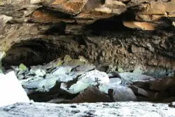
Civil Defense Caves
Rexburg, Idaho
23.0 miles N of Rexburg, IdahoThe caves are large lava tubes. The name comes from the cold war era when they were anticipated as a safe area in the case of an attack. The entrance is pretty bouldery and does require a small amount of agility. Once in, it's easy enough for even little kids. Off the entrance, there are two main tubes. The right is pretty easy, the left is a little more difficult but does have bats. The right tube is mostly a flat gravely floor with a very large arched ceiling with rocks and boulders here and there. There's plenty of room to run around. College kids often play glow in the dark tag and other similar night games out here. It's pretty well patroled due to the high interest. At the end is a little more like caverns that you can crawl around through.
The caves are pretty cold year round. You're even likely to find some ice near the entrance. You'll want to bring jackets, lights, and good footwear. Sadly there is quite a bit of broken glass throughout the caves.
The dirt road up to the caves is very rocky and often washed out. You probably want to drive something with pretty good clearance.
The caves are closed October through April to protect the bat habitat.
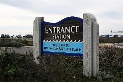
Half Moon Bay State Beach
Half Moon Bay, California
1.0 miles W of Half Moon Bay, CaliforniaHalf Moon Bay State Park's Coastside Trail runs parallel to the Pacific Coast along what used to be the Ocean Shore Railroad. The railroad itself was in operation for just 14 years before it was driven out of business in the early 1920s by the automobile. However, the railroad had a tremendous effect on the Northern California coastline. It opened the area to agriculture, created new communities along the shoreline and made the coastal beaches prime tourist destinations. The Coastside Trail is truly a destination trail. It offers sweeping views of the Pacific Ocean, access to several beaches and excellent nature viewing. Bird watching is quite good and a popular activity here. Red-tailed hawks, blue herons and red-winged blackbirds are spotted frequently, and large hawks can often be seen perched on benches and the trail's split-rail fence. Half Moon Bay State Beach is also home of the world-famous Mavericks, a surfing spot near Pillar Point that's visible from the trail. In winter, surfers can ride waves up to 80 feet high here.Courtesy of traillink.com
1.5 mi
 Full Listing
Show more
Backpack, Cave, Hike
Last visited on 27 May 2017
Full Listing
Show more
Backpack, Cave, Hike
Last visited on 27 May 2017
Timpanogas Cave
Provo, Utah
14.7 miles N of Provo, UtahKnown for it's colorful cave decorations, the Timpanogas cave attracts numerous visitors per year, is steep but it's paved so that visitors can access the cave. To access the cave, visitors take a 1.5 mile on a trail, leading to the cave. The trails to the cave is only open for tours May through September depending on funding and weather conditions. There are many colorful cave features (rocks) including cave bacons, cave columns, flowstone, cave drapery and many others. These features are formed when water travels through a tube, evaporates and leaves mineral deposits at the end.
The cave was founded by two rock climbers, James W. Gough and Frank Johnson in 1913. In addition, other caves were found by hikers (middle cave and the Hansen cave-found prior to the Timpanogas cave.) The caves were known and venturers occasionally vandalized the Hansen cave; as a result the US Forest Service were called to protect and preserve the caves. The National Park Service maintained the caves after the US Forest Service and the WPA (Workers Progress Administration) built a number of park structures to showcase the caves.
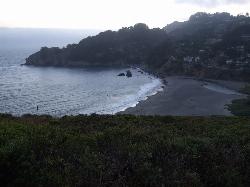
Muir Beach
Muir Beach, California
0.3 miles E of Muir Beach, CaliforniaMuir Beach is a little gem nestled away in the hills North of San Francisco, not far from the Muir Woods National Monument. There's a great beach and an entire network of trails. To get to the beach is a delightful 0.2 miles along a bridge and sandy pathway. You'll find plenty of informational placards along the way, great for kids, or even the mildly curious adult.
Once you're here, you can sit and enjoy the beach, get started on the Coastal Trail, explore along the cliffside trails to the south, or simply enjoy a picnic at the tables near the parking lot while you take in the beautiful sunset over the Pacific.
St. Anthony Sand Dunes
Saint Anthony, Idaho
6.0 miles NW of Saint Anthony, IdahoBest known for their offroad riding conditions, the St. Anthony Sand Dunes provide a sledding experience unlike any other. These mountains of sand are fun for sliding down in the summer but during the winter, you won't find a smoother surface for the snow. There are hills everywhere you look and it doesn't take much to find a bowl or halfpipe like experience.
3.8-6.4 mi
 Full Listing
Show more
Camp, Hike
Last visited on 9 Jul 2016
Full Listing
Show more
Camp, Hike
Last visited on 9 Jul 2016
Table Rock / Table Mountain
Driggs, Idaho
10.0 miles E of Driggs, IdahoAt roughly 11,100 feet, the flat-topped summit of Table Mountain serves up what many consider the single finest view of the Grand Teton anywhere — and one of the great day hikes on the quiet, western (Idaho) side of the range. From the broad mesa top you stand just far enough back to take in all three Teton peaks at once, yet close enough to pick out the detail on the Grand's sheer east face across the deep gulf of the canyon. It's a jaw-dropping payoff, and a hard-earned one.
The mountain holds a remarkable place in history. In 1872, pioneering survey photographer William Henry Jackson hauled his heavy glass-plate camera gear by mule to the top of Table Mountain and made the first photographs ever taken of the Grand Teton — images that helped introduce the range to the wider world and build support for protecting it. Jackson chose this peak precisely because its gentle western slopes could be reached without technical climbing, and that's still what makes the summit attainable for strong day hikers today.
The trailhead sits at the end of Teton Canyon Road outside Driggs and Alta, and nearly the entire route lies within the Jedediah Smith Wilderness of the Caribou-Targhee National Forest. There are two main ways up, and both climb over 4,000 feet. The Face Trail is the steeper, shorter option (about 3.5 miles one way), skipping the switchbacks to head more or less straight up. The Huckleberry (North Fork) Trail is longer but far more gradual (about 6.5 miles one way), following and crossing the North Fork of Teton Creek — handy spots to filter water — through meadows and, in mid-to-late summer, ripe huckleberries for those who beat the crowds to the bushes. Many hikers link the two into a big loop of roughly 11–13 miles, and tough-but-knee-conscious hikers generally prefer to climb up the steep Face and come down the gentler Huckleberry, sparing their knees the pounding of a steep descent. The lower trail is a delight in its own right, tracing rushing Teton Creek past a string of waterfalls.
The wildflowers here are spectacular. As the snow recedes, Table Mountain's meadows erupt in color — sweeping displays of lupine, arrowleaf balsamroot, and Indian paintbrush, with columbine in the shadier pockets and delicate alpine blooms up high. In the Tetons the canyon meadows tend to peak from early-to-mid July, while the highest ground saves its show for late July into August; even when snow still blocks the upper trail, the lower meadows near the trailhead put on an easy, photogenic display. It's one of the finest wildflower hikes in the region.
This is high, exposed country, so plan accordingly. At over 11,000 feet the air is thin and the weather changes fast: afternoon thunderstorms build quickly over the peaks in summer, so start early and aim to be off the open summit by early afternoon. Table Mountain is enjoyed year-round — it's a popular snowshoe and backcountry-ski destination in the snowy months. If you're after dry summer hiking, though, know that you're likely to encounter snow on the upper mountain before mid-July: early-season snowfields often begin around 9,500 feet with larger patches up high, and the Huckleberry side can hold avalanche debris and downed trees until it melts out. It's frequently still passable with the right footwear — just come expecting it. Conditions are typically most reliably snow-free from about mid-July through September. It's also easy to lose the trail, especially on the descent, so pay attention to your route and carry a map or GPS. Keep an eye out for wildlife, too — moose are a common sight in the canyon, and the area is home to the occasional mountain lion.
Bring layers, sun protection, plenty of water (and a filter), and sturdy footwear for the long, steep grade. You can check current conditions on the webcams at tetoncam.com before you drive up. Backpackers sometimes camp in the meadows below the summit to catch the Grand at sunrise — an unforgettable sight — while following Leave No Trace and wilderness regulations. However you do it, Table Mountain earns its reputation: a leg-burning climb to a mesa in the sky, carpeted in wildflowers, with the Grand Teton filling the horizon just as it did for Jackson a century and a half ago.
0.6-4.7 mi
 Full Listing
Show more
Cross-country Ski, Hike, Horseback, Mountain Bike, Snowshoe
Last visited on 30 May 2015
Full Listing
Show more
Cross-country Ski, Hike, Horseback, Mountain Bike, Snowshoe
Last visited on 30 May 2015
Harriman State Park
Island Park, Idaho
8.3 miles SW of Island Park, IdahoHarriman State Park is found 38 miles from Yellowstone along Henry's Fork. This 11,000-acre wildlife refuge is open year round for most activities. In addition to having beautiful scenery and wildlife, the area also has several houses that were built when the park was a privately owned ranch. The area is home to one of the best fly-fishing streams in the country, an eight mile portion of Henry's Fork river. There are many activities here including horseback riding, hiking, tours of the ranch, and fly-fishing.
During the summer, the trails through Harriman are a great place to hike and explore. There are plenty of wildflowers growing and the lakes and rivers flow nicely. Visitors will be able to see plenty of small wildlife, including swans on Silver lake, and there might even be a chance to see a moose or a bear. Part of the park crosses into the Caribou-Targhee National Forest. Along the river, there are beautiful views of the Tetons and the Yellowstone Plateau.
In the winter, the park is home to more than 24 miles of Nordic ski trails. The trails all vary in level of difficulty and distance. Most of the trails will go around Silver Lake and loop back towards the ranch houses. Other winter activites include fat biking and snowshoeing. The ranch houses are great in the winter because several have large fireplaces to warm up by.
The ranch houses can be rented out by visitors and have different accommodations for each house. Some of the houses include large gathering areas great for large groups of people. During different seasonns of the year the park offers events for the general public including star gazing and music camps.
This is an Idaho State Park and there are day use fees. Passes have reciprocity with Mesa Falls State Park which is only about 20 minutes away.
Mesa Falls
Ashton, Idaho
10.0 miles NE of Ashton, IdahoUpper Mesa Falls, aka Big Falls, is an absolutely awesome waterfall on the Henrys Fork of the Snake River. The falls drop 114 ft. and measure 300 ft. across. To get to the falls from the parking lot is 0.2 miles of paved walkway and several sturdy stairs with plenty of gaurdrails and handrails. There are several platforms along the route for viewing and taking photos. Catch it in the morning to see the rainbows in the lingering mist that often rises well above the platforms. There's a wheelchair accessible path that can get a pretty good view of the falls but does not go right down to it.
Lower Mesa Falls is about a mile down river from the Upper Falls. There's two great viewing options. One is from a cliff hovering 200 feet above the falls and the other is from the the Observation Site sitting 0.25 miles away and almost 500 feet above the falls. To get to the cliff above the falls, there's a trailhead on the South East end of the main parking lot. The trail is 1 mile each way (2 mile out and back) with about a 100 ft. difference in elevation (about the same as the stairs the the Upper Falls platforms). The trail goes through the woods well away from the river itself but there are no guardrails at the end when you're peering over the edge of the cliffs to see the waterfall. To see the falls from the observation site is free and the walk from your car to the lookout is only about 500 ft.
This is an Idaho State Park and there are day use fees. Passes have reciprocity with Harriman State Park which is only about 20 minutes away. Get there before 5pm to check out the old inn which has been transformed into a fun and informative visitor's center.
×


