


2.0K Best Swimming Holes in Arizona by camilledupar
first prev 1 next lastHave you ever been in a beautiful waterfall amidst an equally beautiful desert? Some of Arizona's best swimming holes are a short hike away! Come and explore the best of what the Grand Canyon state has to offer by exploring the other great canyons! This list is a great start to help you find your next favorite river, pond, pool, or waterfall!
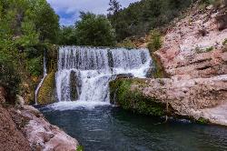
Fossil Creek Dam (Toilet Bowl)
Pine, Arizona
6.6 miles W of Pine, ArizonaHidden in the high desert between Pine and Camp Verde, Fossil Creek is one of Arizona's two federally designated Wild and Scenic rivers — a spring-fed, travertine-blue oasis that pours some 20,000 gallons a minute out of the ground and brings its canyon vividly to life. Along its course lie several beloved swimming and hiking destinations, including two waterfalls; this one, the “Toilet Bowl,” is the swimming hole at the old Fossil Creek dam.
Despite the unglamorous nickname, it's a gorgeous spot. The name comes from a round, natural chute on the side of the river: jump or slide in and the swirling water spins you around the “bowl” before flushing you out into the deep main pool at the base of the falls. There's even a shallow cave beside the pool where swimmers duck out of the desert sun. It's a favorite with cliff-jumpers and swimmers, though water levels and submerged hazards change from year to year, so it's always worth checking the depth and conditions carefully before you leap.
The dam is reached by hiking in on the Flume Trail from the west or the Fossil Springs Trail from the east. Come prepared either way: the trails are hot and exposed, and the climb back out — especially via Fossil Springs — is long and strenuous, gaining well over a thousand feet in the desert heat. Carry far more water than you think you'll need, and remember that the creek water is not safe to drink without purification.
A permit is required to visit from April 1 through October 1, and the Coconino National Forest enforces it strictly. Each permit covers one vehicle at a designated lot and is reserved in advance through Recreation.gov; group size is capped (currently 12 people), drivers must reach the access point by early afternoon (the entry gate closes at 3 p.m.), and there is no camping within the permit area during the season. Book ahead, because permits for this popular spot go fast. Outside the permit season no permit is needed, but the access roads and weather can be far less forgiving.
The dam is a relic of history. For most of the twentieth century, Fossil Creek's water was diverted through a flume to a small hydroelectric plant — one of Arizona's first — leaving the creek bed nearly dry. In 2005 the dam was decommissioned and the springs' full flow was returned to the channel; the creek's travertine pools and lush greenery came roaring back to life, in one of the West's great river-restoration stories.
Plan for a full desert day: sturdy shoes, sun protection, plenty of food and water, and a dry bag for valuables. Be especially careful of the heat in summer, when midday temperatures in the canyon can be genuinely dangerous, and pack out every bit of trash to protect this fragile, precious oasis. With a permit in hand and an early start, the Toilet Bowl rewards you with one of the most memorable swimming holes in all of Arizona.
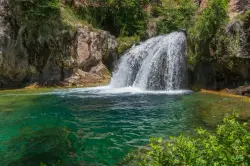
Fossil Creek Waterfall
Pine, Arizona
9.2 miles W of Pine, ArizonaFossil Creek is one of Arizona's two designated "Wild and Scenic" rivers. The waterfall is the most popular place to visit to cool off and see the natural beauty. Located between the towns of Strawberry and Camp Verde, south of Flagstaff, the creek is a uniquely lush piece of Arizona's Coconino National Forest. The waterfall is a short hike away from the parking area, which is itself a long drive down a dirt gravel road. At the base of the falls is a pool deep enough to swim in, and refresh from a hot day.
There is a restroom at the trailhead, but there is no potable water or trash service, so be sure to pack out all trash to keep the environment clean for the others who follow behind. Take care to stay on the trail, since many have seen snakes along the path.
Note that this hike does not lead to the old Fossil Creek Dam, or the "Toilet Bowl", as that is a separate trail.
From April to October, registration and a $10 pre-printed parking permit is required for day use at the site. You cannot get a permit on site, so make sure to have it before you leave. The rest of the year, no permit or registration is required. You can get your permits at https://www.recreation.gov/permits/251863
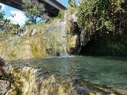
Little Jamaica aka Desert Springs
Littlefield, Arizona
0.8 miles NE of Littlefield, ArizonaLittle Jamaica, also known as Desert Springs or Littlefield Springs, was for years one of the most beloved little swimming holes in the Arizona Strip, a surprising desert oasis along the Virgin River near Littlefield, Arizona, about a 30-minute drive from St. George. A short quarter-mile walk led to a man-made pool fed by a warm mountain spring, with small waterfalls trickling through a lush pocket of green in the stark desert landscape. It earned its nickname for that unexpectedly tropical feel, and it was a favorite quick escape for students and families from St. George and Mesquite.
The important thing to know now is that Little Jamaica is closed. As of May 2022, the Arizona Department of Transportation closed off access to the area below where the man-made pool sat, and the swimming hole itself appears to have been dismantled. If you've come across older guides or videos showing the oasis and its waterfalls, this is the update that matters: it is no longer an open, accessible destination, and the pool that made it special is gone.
We're keeping this listing to make that status clear rather than to send anyone down to a closed site. Please respect the ADOT closure and do not trespass to reach it. Beyond the access issue, the setting always carried its own hazards, slippery, algae-slicked rock around the spring and pool, and the closure removes any safe, legal way to enjoy it.
The history is worth remembering fondly. Fed by a genuine mountain spring emerging into a built pool along the Virgin River, Little Jamaica was a rare desert water feature, cool and green amid red rock and creosote, close enough to the freeway to be an easy after-class or after-work stop. For a long time it was one of those word-of-mouth local treasures that made the Arizona Strip feel full of secrets.
For visitors still hoping to find water in this corner of the desert, the wider region offers legitimate, open alternatives: the developed and dispersed recreation along the Virgin River Gorge, the water features and parks around St. George and Mesquite, and the many open swimming and hiking spots of nearby southern Utah. Seeking those out is a far better plan than making the trip to a dismantled, closed site.
Treat Little Jamaica as a closed chapter, a fondly remembered desert oasis that is, for now, off the map. Respecting the closure is the right call, and it keeps the focus on the many places in the region that are still open, still watered, and still worth the drive.
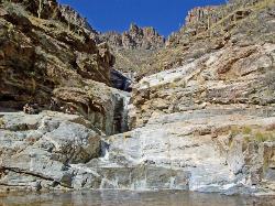
Seven Falls
Tucson, Arizona
8.6 miles NE of Tucson, ArizonaSeven Falls is one of the most rewarding hikes in the Tucson area — a desert oasis of tiered waterfalls and clear pools tucked into Bear Canyon within the Sabino Canyon Recreation Area of the Coronado National Forest. When the water is running, the creek spills down a series of seven ledges into inviting pools at the base of the canyon, a startling splash of blue and green against the saguaro-studded slopes of the Santa Catalina Mountains. It's regularly listed among the very best outdoor outings in southern Arizona.
The classic route heads up Bear Canyon and crosses the stream seven times on the way to the falls — wet feet are part of the experience when the water is high. From the main visitor center it's roughly an 8.4-mile round trip, but you can trim it substantially by riding the Bear Canyon shuttle to the trailhead, which cuts off about 1.8 miles each way (leaving around a 4.5-mile round trip on foot). At the falls, the pools are a popular place to cool off and picnic on the warm rocks before the walk back.
Timing is everything here, because the falls are seasonal. They're fed by snowmelt and rain in the high country, so they run best from late winter into spring (roughly October through April is the prime window); by early summer they can slow to a trickle or dry up entirely. Check recent conditions before you make the trip — a flowing Seven Falls is a completely different experience from a dry one.
Come prepared for the desert. As with most Tucson-area hikes, summer is dangerously hot — midday temperatures on this largely shadeless trail can be brutal, so avoid it in the heat of summer and start early no matter the season. Carry far more water than you think you'll need, wear sun protection and sturdy shoes, and be mindful that flash floods can turn the stream crossings dangerous during and after storms, when fast-moving water becomes a serious and sometimes deadly hazard. Rattlesnakes are also active on warm days.
The falls themselves are the payoff: seven tiers of water sliding over smooth granite into a chain of pools, the largest deep enough for a refreshing dip when flows are strong. It's a magical, unexpectedly green pocket of the desert, and the surrounding canyon teems with life — watch for bighorn sheep on the high cliffs, javelina and deer in the brush, lizards on the sun-baked rock, and hawks riding the thermals overhead. Give yourself time to linger at the water before the long walk back.
A few fees apply. The Sabino Canyon Recreation Area charges an amenity fee (around $8 per vehicle), payable at the parking entrance or covered by an America the Beautiful pass. The shuttle to the Bear Canyon trailhead is a separate, optional cost (roughly $8 for adults and $5 for children; rates change yearly), well worth it if you'd rather spend your energy on the canyon than on the approach road. With good timing and plenty of water, Seven Falls delivers a genuinely special reward — a lush, pool-filled canyon in the heart of the Sonoran Desert.
Havasu Falls Trail
Flagstaff, Arizona
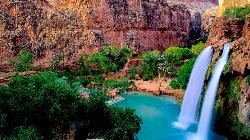
89.4 miles NW of Flagstaff, ArizonaFew places in America inspire as much longing as Havasu Falls — the impossibly turquoise waterfall that has become a bucket-list icon of the Southwest. It lies deep in Havasu Canyon on the Havasupai Reservation, a side canyon of the Grand Canyon so remote it can be reached only on foot, by pack mule, or by helicopter. The Havasupai are the “people of the blue-green water,” and this is their homeland: a hidden desert oasis where waterfall after waterfall pours over red travertine cliffs into pools the color of the Caribbean.
That astonishing blue-green color is no trick of the light. Havasu Creek is spring-fed and saturated with calcium carbonate, which scatters sunlight into the vivid turquoise hue and, over time, deposits as travertine — building the smooth ledges, terraces, and natural dams that shape the pools. The mineral-laden water even rebuilds the falls after floods, which is why the canyon's cascades have shifted and been renamed over the years.
The falls come in a spectacular string below the village. Fifty Foot Falls and Navajo Falls — reshaped by a major 2008 flood and sometimes called Rock Falls — come first, followed by the star of the show: Havasu Falls itself, a roughly 100-foot plunge into a wide, swimmable turquoise pool that ranks among the most photographed sights in the world. Below the campground, Mooney Falls drops nearly 200 feet, the tallest in the canyon, and reaching its base is an adventure in itself: a steep scramble down through carved tunnels and along chains and slick ladders bolted to the dripping travertine wall. Farther on, about four miles past the campground, Beaver Falls tumbles in tiers through a lush grotto, and the truly ambitious can follow Havasu Creek roughly eight miles all the way to its confluence with the Colorado River.
Getting there is a genuine journey. The hike begins at Hualapai Hilltop and drops about 2,000 feet of switchbacks into the canyon, then follows a sandy wash 8 miles to the village of Supai — one of the most remote communities in the lower 48, so isolated that the U.S. mail still arrives by pack mule. From the village it's another 2 miles past Havasu Falls to the campground, which stretches about a mile along the creek between Havasu and Mooney Falls, with drinking water available at Fern Spring. All told it's roughly 10 miles each way, and the climb back out at the end is long and hot.
This is a permit-only destination, and getting one is the hardest part of the whole trip. The Havasupai Tribe requires a reservation for every visitor, and day hiking is not allowed — all permits are for a fixed three nights and four days. Camping permits run about $455 per person for the stay (a lodge in Supai is the pricier alternative), sold only through the tribe's official reservation website. New permits for the year are released on February 1 at 8:00 a.m. Arizona time and routinely sell out within minutes to a virtual line tens of thousands deep; a paid early-access window and a cancellation-transfer system offer other ways in. Do not hike in without a confirmed reservation — visitors without permits are turned around, and there are no walk-ups.
Come prepared and treat the canyon with respect. Summer is brutally hot, so many hikers walk the exposed miles at dawn and carry far more water than they think they'll need. Flash flooding is a serious, recurring danger here — the canyon has flooded and forced evacuations more than once — so watch the weather, camp on high ground, and heed any guidance from tribal rangers. Remember that this is tribal land and a living community, not a park: alcohol and drones are banned, pets should be left at home, and everything you carry in must be packed out. Book far ahead, aim for the milder weather of spring or fall, and Havasu Falls will repay the effort with one of the most unforgettable landscapes on the continent.
Pebble Beach
Mesa, Arizona
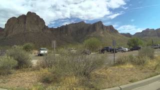
17.7 miles NE of Mesa, ArizonaPebble Beach is one of the most popular spots to cool off on the Lower Salt River, tucked into the Tonto National Forest about 20 miles northeast of Mesa, Arizona. On a blazing Phoenix-area summer day, this stretch of clear, cool river — with its sandy beaches and easy paved access — is a slice of paradise, and one of the classic places to swim, picnic, and float the Salt.
The big draw is the water. Pebble Beach has gentle, sandy-to-pebbly beach areas where families spread out for the day, wade in, and splash around, and it's a prime launch and landing spot for the quintessential Arizona summer tradition of tubing the Salt River — drifting lazily downstream on an inner tube (rentals are available from nearby outfitters). You can also swim, paddleboard, kayak, and fish, or simply claim a shady spot and watch the river roll by.
Keep your eyes open for the river's most famous residents: the Salt River wild horses. A protected herd roams this corridor, and it's common to see them grazing along the banks or wading in the shallows — a genuinely magical sight, and a reminder to give them plenty of space and never feed or approach them.
A few practical details. The site has basic amenities — picnic tables, restrooms, and about 20 ramadas with grills — but come prepared, as it's a day-use area, not a resort. A Tonto Pass is required for all Salt River access points: day use runs about $8 per vehicle if you buy it ahead at a Forest Service office or vendor, or $12 on site, so grab one before you go. The paved route in follows Bush Highway (Forest Road 204) and Forest Road 169.
Pebble Beach is one of several developed access points along the Lower Salt River Recreation Area, a beloved desert-river corridor that comes alive every summer. The saguaro-studded Sonoran Desert setting, backed by the rugged Goldfield and Superstition Mountains, is quintessential Arizona, and cottonwood-lined banks offer welcome shade. Weekends and holidays draw big, festive crowds of tubers, families, and swimmers — it can feel like a party on the water — while weekday mornings are far quieter. Whenever you go, respect the wild horses and other wildlife, and help keep the beloved Salt clean by carrying out everything you bring.
Come ready for the desert river: water shoes for the rocky spots, plenty of drinking water, sun protection and shade, and a dry bag for valuables. Watch the current and keep a close eye on kids, especially when the river runs higher, and pack out every bit of trash to protect this beautiful stretch of the Salt. Summer is peak season by far — arrive early on weekends to claim a beach — and few things beat a hot Arizona day spent floating and swimming at Pebble Beach.
Tanque Verde Falls
Tucson, Arizona
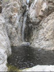
15.4 miles E of Tucson, ArizonaTanque Verde Falls are a set of waterfalls and pools inside of Tanque Verde Canyon near Tucson, Arizona. The canyon is located within Coronado National Forest. There is a parking area on the side of the road, near a trailhead. From there, it's a short hike to the water. An optional trail leads directly to the falls themselves, although this portion is a slightly more difficult climb due to boulders and such along the path. Due to the short hike distance, this is a popular location to cool off.
The best time to go is from September through May, avoiding the summer heat.
This area is considered the "most dangerous" waterfall hike in Arizona, as there have been around 30 deaths since 1971 due to flash flooding and cliff jumping. The area is at high risk for flash floods during monsoon season, and the water level varies, so be very cautious. Pay attention to local weather conditions, stay away from slippery rocks, and don't jump if you're unsure of how deep the pool is.
Romero Pools
Tucson, Arizona
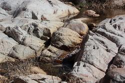
14.1 miles N of Tucson, ArizonaNestled in Arizona's Catalina State Park, just north of Tuscon, are the Romero Pools. The pools are accessible by a hike through Romero Canyon that takes an average of two hours. The hike gets progressively more difficult as you go along, making a dip in the pools all the sweeter. Although the pools are fed by a stream that dries up seasonally, the pools are there year round to enjoy.
It is advised to avoid the pools during rainstorms, as there is an increased risk of flash flooding. On the other hand, a few days after the rain, the pools will be more full. Due to heat concerns, this hike is also best used from September through May.
As this trail is located within a state park, an entrance fee of $7/vehicle (up to 4 adults) applies.
Hutch's Pool
Tucson, Arizona
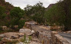
8.6 miles NE of Tucson, ArizonaHutch's Pool is a popular destination near Tucson, Arizona. Famed for its cool water in the desert heat, the pool is an 8-mile hike round trip into the canyons and mountains of Sabino Canyon Recreation Area. Though the hike officially begins at the Sabino Canyon Recreation Trailhead, to get there, you need to travel an additional 3.8 miles from the parking lot by the visitor's center, potentially making a 16 mile round trip in total (though the path from the parking lot to the trailhead is paved, and has several areas to stop and rest.) There are spectaular views of the desert landscape along the trail, and an abundance of cacti.
The hike itself has little shade, so sunscreen and a hat are encouraged. Though Hutch's Pool is refreshing and a welcome relief from the warm sun, the cooling effects will have worn off by the time you're well on your way, so bring plenty of water. As with most hikes in Arizona, it is best advised to plan your hike from October through May, avoiding the excessive heat of summer.
As the trail is located within Catalina State Park, there is a $5 day pass required per vehicle. In addition, an optional tram ride to the trailhead (Stop #9) is $10 for adults, $5 for children age 3-12.
Arizona Hot Springs
Willow Beach, Arizona
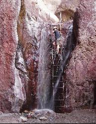
8.1 miles NW of Willow Beach, ArizonaArizona Hot Springs is located within a 3.25 mile hike along desert canyons inside of Lake Mead National Recreation Area.
At the trail head, there are two hikes available; the Liberty Bell Arch trail brances off, and does not go to the hot spring. Follow the White Rock Canyon trail to find the spring.
This hike makes for a nice overnight outing, as there are nice places to camp at the river and in the canyon just above the hot springs. Courtesy of birdandhike.com
Safety: The trail and subsequent springs are CLOSED during summer, June-September, due to extreme temperature conditions--however, during the rest of the year, weather permitting, it is a great hike.The hike is rated as "strenuous," and it is advised that you should travel with a companion. Once at the hot springs, take care not to put your head underwater, as this could put you at risk for a rare ameobic infection, although there are signs on site that will remind you.


