


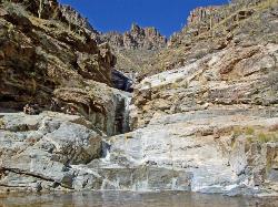
Hutch's Pool
Tucson, Arizona
| Address: | 5700 N Sabino Canyon Rd, Tucson, AZ 85750, USA |
| GPS: |
32°18'37.8"N 110°49'20.7"W Maps | Directions |
| State: | Arizona |
| Trail Length: | 15.80 miles |
| Trail Type: | Out & Back |
| Hike Difficulty: | Intermediate |
| Elevation Gain: | 2450 feet |
| Trails/Routes: | 0.5-3.8 mi |
Trails Rocks
Hike and Swim
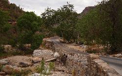
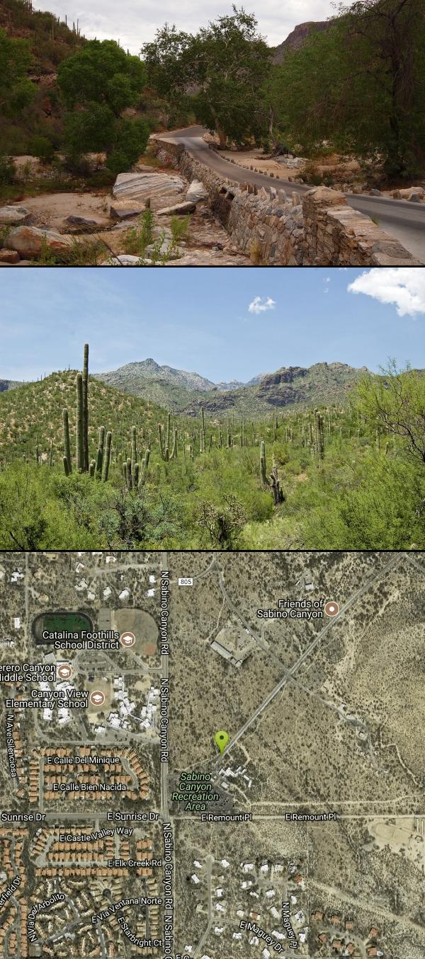
Hutch's Pool is a popular destination near Tucson, Arizona. Famed for its cool water in the desert heat, the pool is an 8-mile hike round trip into the canyons and mountains of Sabino Canyon Recreation Area. Though the hike officially begins at the Sabino Canyon Recreation Trailhead, to get there, you need to travel an additional 3.8 miles from the parking lot by the visitor's center, potentially making a 16 mile round trip in total (though the path from the parking lot to the trailhead is paved, and has several areas to stop and rest.) There are spectaular views of the desert landscape along the trail, and an abundance of cacti.
The hike itself has little shade, so sunscreen and a hat are encouraged. Though Hutch's Pool is refreshing and a welcome relief from the warm sun, the cooling effects will have worn off by the time you're well on your way, so bring plenty of water. As with most hikes in Arizona, it is best advised to plan your hike from October through May, avoiding the excessive heat of summer.
As the trail is located within Catalina State Park, there is a $5 day pass required per vehicle. In addition, an optional tram ride to the trailhead (Stop #9) is $10 for adults, $5 for children age 3-12.
More Information
PERUSAHAAN DEWI11 ⨶ TERPERCAYA DENGAN PENGALAMAN BERMAIN BERKUALITAS
Dewi11 Hadir dengan teknologi modern, layanan profesional, dan komunitas pemain yang aktif, kami menghadirkan pengalaman game online yang seru, aman, dan menghibur di berbagai platform.
https://www.toddshikingguide.com/Hikes/Arizona/Southeast/Southeast16.htmtripadvisor.com
Please enable JS and disable any ad blocker
https://www.tripadvisor.com/Attraction_Review-g60950-d9454091-Reviews-Hutch_s_Pool-Tucson_Arizona.htmlBe courteous, informed, and prepared. Read trailhead guidelines, stay on the trail, and don't feed the wildlife.
Read More- Plan Ahead and Prepare
- Travel & camp on durable surfaces
- Dispose of waste properly
- Leave what you find
- Minimize campfire impacts
- Respect wildlife
- Be considerate of other visitors
Directions
From Tucson, Arizona
- Head west on E Broadway Blvd toward S Country Club Rd (39 ft)
- Turn right at the 1st cross street onto N Country Club Rd (1.0 mi)
- Turn right onto E Speedway Blvd (2.0 mi)
- Turn left onto N Swan Rd (5.0 mi)
- Turn right onto E Sunrise Dr (4.1 mi)
- Turn left onto N Sabino Canyon Rd (364 ft)
- Turn right at N Pantano RdPartial toll road(486 ft)
- Turn leftToll road(312 ft)
- Turn right at N Pantano RdToll road(52 ft)
- Turn leftToll roadDestination will be on the left(151 ft)
There are two options to get to the trail down to Hutch's Pool. The first is to hike along the paved road for 4 miles until you reach the official trailhead. The second is to pay $10 for a tram ride that will take you to the trailhead from the visitor center parking lot and back. Many prefer the tram, especially after the long hike back from the pool, but it is not necessary to return to your vehicle.


Added by camilledupar
Other Swimming Holes and Hiking Trails Nearby
Seven Falls
Tucson, Arizona
0.1 miles SWSeven Falls crosses a stream seven times through Bear Canyon before arriving at pools best visited in late winter when snowmelt keeps the water flowing strong.
Hike, Swim 1.0-1.2 mi
Maiden Pools
Tucson, Arizona
2.9 miles NWGranite pools carved smooth by the Ventana Stream, best filled in late winter and spring, with shading oak trees and big rocks for picnicking — 2.4 miles up Ventana Canyon Trail.
Hike, Rock Climb, Swim 1.2 mi
La Milagrosa Canyon
Tucson, Arizona
5.4 miles EA hidden canyon east of Tucson with rock-climbing walls and a seasonal waterfall pooling into swim basins — best after fall or winter rain, with boulder scrambling required.
Hike, Mountain Bike, Rock Climb, Swim 2.4 mi
Sycamore Reservoir
Tucson, Arizona
6.1 miles EA small lake up in Bear Canyon on Mount Lemmon with a sandy shore and a dam that creates a small waterfall — best hiked in fall, winter, or spring, when the desert foliage is at its most striking.
Hike, Swim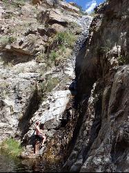
Seven Cataracts
Tucson, Arizona
6.6 miles NEA set of waterfalls deep in Willow Canyon near Tucson, reached by off-trail canyoneering scrambles — visible from the Catalina Highway pulloff after rainfall.
Canyoneer, Hike, Swim 3.6 mi
Lemmon Pools
Mount Lemmon, Arizona
9.0 miles NEA steep, rocky 8.5-mile trek through the Wilderness of Rocks to hidden pools tucked in the Santa Catalinas.
Hike, Swim 1.4-1.8 mi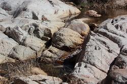
Romero Pools
Tucson, Arizona
9.4 miles NWA two-hour canyon hike through Romero Canyon leads to year-round stream-fed pools surrounded by Catalina State Park desert — best enjoyed September through May.
Hike, Swim 1.0 mi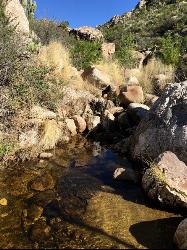
Montrose Pool
Tucson, Arizona
9.4 miles NWA seasonal catchment pool about a mile up the Romero Canyon Trail in Catalina State Park, filling after rainfall — best hiked October through May and dog-friendly to the pool.
Hike, Swim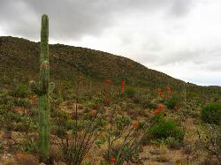
Cactus Forest Trail
Tucson, Arizona
9.7 miles SEA flat, multi-use 2.5-mile desert trail through old-growth saguaros and cholla in Saguaro National Park East — welcoming to hikers, horses, and bikes, with the Rincon Mountains as a stunning backdrop.
Hike, Mountain Bike 0.5 mi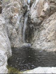
Tanque Verde Falls
Tucson, Arizona
10.0 miles SEWaterfalls and pools in Tanque Verde Canyon reachable on a short hike — but this site has about 30 deaths since 1971 from flash flooding and cliff jumping. Check weather carefully and use extreme caution.
Hike, Swim 4.4 mi
Chiva Falls
Mount Lemmon, Arizona
11.2 miles EA desert waterfall tucked in Coronado National Forest, best reached by mountain bike or motorized vehicle on rocky double-track — with a pool at the bottom to cool off in (check depth before diving).
Hike, Mountain Bike, Swim 0.2-4.6 mi
Frog's Hollow
Vail, Arizona
14.5 miles EMultiple small pools and shallow waterfalls in a frog-filled Arizona canyon, best in fall through spring after rain — hike via the Arizona or Indian Springs Trail.
Hike, Mountain Bike, Swim


