


Havasu Falls Trail
Flagstaff, Arizona

| Address: | Supai, AZ 86435, USA |
| GPS: |
36°9'35.2"N 112°42'33.6"W Maps | Directions |
| State: | Arizona |
Waterfalls Streams National Park
Backpack, Dive, Horseback, and Swim
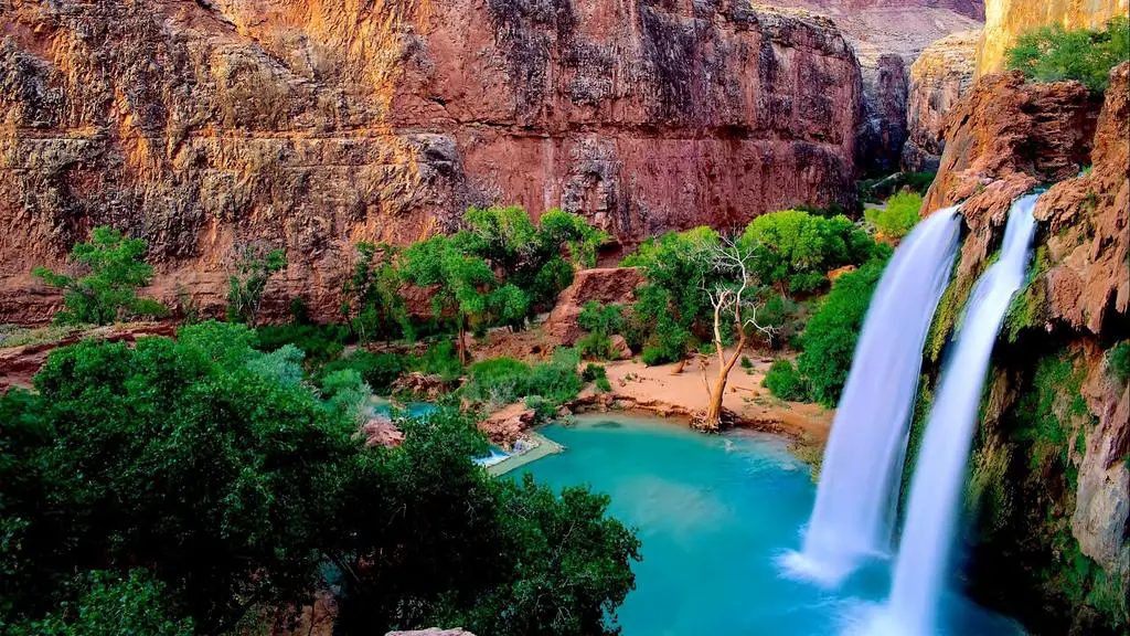
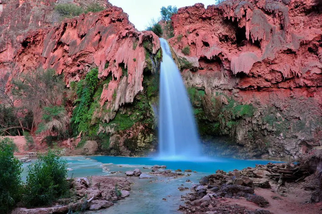
Few places in America inspire as much longing as Havasu Falls — the impossibly turquoise waterfall that has become a bucket-list icon of the Southwest. It lies deep in Havasu Canyon on the Havasupai Reservation, a side canyon of the Grand Canyon so remote it can be reached only on foot, by pack mule, or by helicopter. The Havasupai are the “people of the blue-green water,” and this is their homeland: a hidden desert oasis where waterfall after waterfall pours over red travertine cliffs into pools the color of the Caribbean.
That astonishing blue-green color is no trick of the light. Havasu Creek is spring-fed and saturated with calcium carbonate, which scatters sunlight into the vivid turquoise hue and, over time, deposits as travertine — building the smooth ledges, terraces, and natural dams that shape the pools. The mineral-laden water even rebuilds the falls after floods, which is why the canyon's cascades have shifted and been renamed over the years.
The falls come in a spectacular string below the village. Fifty Foot Falls and Navajo Falls — reshaped by a major 2008 flood and sometimes called Rock Falls — come first, followed by the star of the show: Havasu Falls itself, a roughly 100-foot plunge into a wide, swimmable turquoise pool that ranks among the most photographed sights in the world. Below the campground, Mooney Falls drops nearly 200 feet, the tallest in the canyon, and reaching its base is an adventure in itself: a steep scramble down through carved tunnels and along chains and slick ladders bolted to the dripping travertine wall. Farther on, about four miles past the campground, Beaver Falls tumbles in tiers through a lush grotto, and the truly ambitious can follow Havasu Creek roughly eight miles all the way to its confluence with the Colorado River.
Getting there is a genuine journey. The hike begins at Hualapai Hilltop and drops about 2,000 feet of switchbacks into the canyon, then follows a sandy wash 8 miles to the village of Supai — one of the most remote communities in the lower 48, so isolated that the U.S. mail still arrives by pack mule. From the village it's another 2 miles past Havasu Falls to the campground, which stretches about a mile along the creek between Havasu and Mooney Falls, with drinking water available at Fern Spring. All told it's roughly 10 miles each way, and the climb back out at the end is long and hot.
This is a permit-only destination, and getting one is the hardest part of the whole trip. The Havasupai Tribe requires a reservation for every visitor, and day hiking is not allowed — all permits are for a fixed three nights and four days. Camping permits run about $455 per person for the stay (a lodge in Supai is the pricier alternative), sold only through the tribe's official reservation website. New permits for the year are released on February 1 at 8:00 a.m. Arizona time and routinely sell out within minutes to a virtual line tens of thousands deep; a paid early-access window and a cancellation-transfer system offer other ways in. Do not hike in without a confirmed reservation — visitors without permits are turned around, and there are no walk-ups.
Come prepared and treat the canyon with respect. Summer is brutally hot, so many hikers walk the exposed miles at dawn and carry far more water than they think they'll need. Flash flooding is a serious, recurring danger here — the canyon has flooded and forced evacuations more than once — so watch the weather, camp on high ground, and heed any guidance from tribal rangers. Remember that this is tribal land and a living community, not a park: alcohol and drones are banned, pets should be left at home, and everything you carry in must be packed out. Book far ahead, aim for the milder weather of spring or fall, and Havasu Falls will repay the effort with one of the most unforgettable landscapes on the continent.
More Information
Grand Canyon National Park Itinerary
This Grand Canyon National Park Itinerary will help you get started as you plan your vacation to Grand Canyon National Park.
https://www.justgotravelstudios.com/collections/national-park-itineraries/products/grand-canyon-national-park-itinerary?ref=9zpxis0diinHavasu and Mooney Falls - Two of Arizona’s Best Swimming Holes
Havasu Falls and Mooney Falls, Two of Arizona’s Best Swimming Holes
http://www.azswimmingholes.com/havasu_falls.htmlHavasu Falls and Havasupai Waterfalls Visitor Information
Your #1 Resource for Information about Havasu Falls and the Havasupai Waterfalls! Read about reservations, lodging, planning, hiking, helicopters and more!
https://waterfallsofthegrandcanyon.com/havasu-falls/Havasupai Backpacking Guide
Overview People often say ‘Havasupai’, when referring to Havasu Canyon, a tributary of the Grand Canyon. It has been made famous by illustrious images of turquoise waterfalls set in red rock canyons and is a true oasis in the Arizona desert. This sacred land is stewarded by the Havasupai, meaning ‘people of the blue-green waters.’ They have lived here for at least 800 years and operate as an independent, sovereign tribe with their own constitution. The main attractions at Havasupai are as follows: Fiftyfoot Falls, Navajo Falls, Havasu Falls, Mooney Falls, Beaver Falls, and the confluence of Havasu Creek and
https://backobeyond.blog/havasupai-backpacking-guide/swimmingholes.org Arizona Swimming Holes and Hot Springs rivers creek springs falls hiking camping o
THE web site for beautiful, natural places for a cool dip or hot soak.
https://www.swimmingholes.org/az.htmlWelcome mikestith.com - BlueHost.com
Bluehost - Top rated web hosting provider - Free 1 click installs For blogs, shopping carts, and more. Get a free domain name, real NON-outsourced 24/7 support, and superior speed. web hosting provider php hosting cheap web hosting, Web hosting, domain names, front page hosting, email hosting. We offer affordable hosting, web hosting provider business web hosting, ecommerce hosting, unix hosting. Phone support available, Free Domain, and Free Setup.
http://www.mikestith.com/havasupai-falls-the-complete-backpacking-guide/- Plan Ahead and Prepare
- Travel & camp on durable surfaces
- Dispose of waste properly
- Leave what you find
- Minimize campfire impacts
- Respect wildlife
- Be considerate of other visitors
Directions
From Flagstaff, Arizona
- Head west toward S Beaver St (282 ft)
- Turn left onto S Beaver St (0.3 mi)
- Turn right onto W Butler Ave (0.2 mi)
- Turn left onto W Historic Rte 66/
S Milton Rd (0.2 mi) - Turn right onto I-40BL W/
W Historic Rte 66 (signs for Los Angeles/ Interstate 40 W/ Interstate 40 Business/ US-66 W) Pass by Valvoline Instant Oil Change (on the left in 0.4 mi)(4.4 mi) - Merge onto I-40 W (69.8 mi)
- Take exit 121 for I-40BUS Loop toward AZ-66/
Seligman/ Peach Springs (0.2 mi) - Turn right onto I-40BL E (1.1 mi)
- Turn right onto AZ-66 W/
W Historic Rte 66 (signs for Peach Springs) (29.4 mi) - Turn right onto Indian Rd 18 (60.2 mi)
- Indian Rd 18 turns slightly right and becomes Indian Rd 18 (0.2 mi)
- Slight rightDestination will be on the left(164 ft)


Other Swimming Holes, Horseback Trails, Diving Platforms, and Backpacking Trails Nearby

Havasupai Falls
Supai, Arizona
0.0 miles NWAn eight-mile hike or horseback ride through the remote western Grand Canyon to the village of Supai and Havasupai Falls — accessible only by foot, horse, or helicopter.
Backpack, Camp, Hike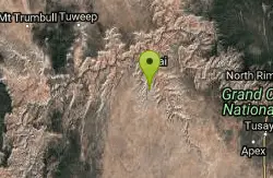
Havasu Falls and Mooney Falls Trail
Supai, Arizona
0.0 miles NEA 12-mile trek into the Havasupai Indian Reservation drops through steep switchbacks and a narrowing canyon to turquoise waterfalls, the Indian town of Supai, and a campground along the creek.
Backpack, Camp, Hike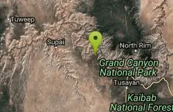
South Bass Trail
Supai, Arizona
18.6 miles EA strenuous 15.6-mile round-trip remote hike in Grand Canyon with no water at the trailhead, 4,400 feet of descent to the Colorado River, and no established campsites below the rim.
Backpack, Camp, Hike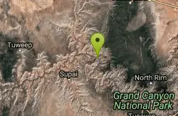
Tapeats Creek to Deer Creek
North Rim, Arizona
19.8 miles NEA remote Grand Canyon backpacking route connecting Tapeats Creek and Deer Creek Trails — from the Colorado River's trackless beaches to a high trail above Granite Narrows.
Backpack, Camp, Hike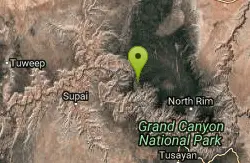
North Bass Trail
North Rim, Arizona
23.4 miles NEA remote North Rim backcountry trail reached via a network of forest service roads, descending to Swamp Point on the Powell Plateau in Grand Canyon NP.
Backpack, Camp, Hike
North Bass Trail to Muav Cabin
North Rim, Arizona
23.4 miles NEA backcountry hike to Muav Cabin on the North Bass Trail in the Grand Canyon's remote North Rim.
Backpack, Hike
Powell Plateau Trail
North Rim, Arizona
23.4 miles NEA rewarding plateau-top day hike or backpack to a remote North Rim plateau, where hikers with enough water can wander for days visiting rim overlooks and hidden draws.
Backpack, Camp, Hike
Deer Creek to Colorado River
North Rim, Arizona
24.5 miles NEA scenic Grand Canyon backcountry route leading to Deer Creek and the Colorado River via the Bill Hall Trail — a rewarding wilderness hike in northern Arizona.
Backpack, Camp, Hike
Thunder River and Tapeats Creek Trail
North Rim, Arizona
24.5 miles NEA 25-mile out-and-back hike on the North Rim leading to Thunder River and Tapeats Creek — recommended only for very experienced outdoorsmen and primarily used for hiking and rock climbing.
Backpack, Camp, Hike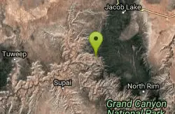
Bill Hall Trail to Monument Point
North Rim, Arizona
24.5 miles NEBill Hall Trail to Monument Point on the Grand Canyon's North Rim — a scenic hike with views into the canyon. Check AllTrails for current conditions.
Backpack, Hike
Hermits Rest Viewpoint to Dripping Springs Trail
Grand Canyon Village, Arizona
28.6 miles EThe hike to Dripping Springs via the Hermit Trail is a rugged, uncrowded Grand Canyon South Rim trek to a fern-fringed spring overhang.
Backpack, Hike
Hermit's Rest Viewpoint to Santa Maria Spring
Grand Canyon Village, Arizona
28.6 miles EThe Hermit Trail to Santa Maria Spring is a rugged, uncrowded Grand Canyon South Rim hike with steep switchbacks and huge views.
Backpack, Hike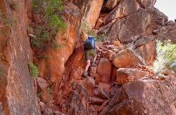
Boucher Trail
Grand Canyon Village, Arizona
28.6 miles EA remote 17.7-mile out-and-back trail to the Colorado River at the base of the Grand Canyon — recommended for very experienced adventurers only, best March through October.
Backpack, Hike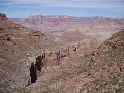
Boucher Trail to Hermit Trail Loop
Grand Canyon Village, Arizona
28.6 miles EA demanding 3–4 day backpacking loop on the Grand Canyon's South Rim — even seasoned hikers consider the Boucher Trail the most difficult and hazardous South Rim route.
Backpack, Camp, Hike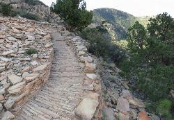
Hermit's Rest Viewpoint to Tonto Trail to Bright Angel Trail
Grand Canyon Village, Arizona
28.6 miles EA multi-day Grand Canyon backpacking route crossing the Tonto Trail from Hermit's Rest to Bright Angel — spectacular inner canyon views with limited water sources and 3,000-foot rim access by foot only.
Backpack, Camp, Hike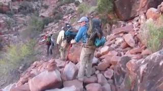
Hermit Trail
Grand Canyon Village, Arizona
28.6 miles EA strenuous, less-crowded Grand Canyon backpacking trail with 2,000 feet of descent in the first 2.5 miles, Cathedral stairs, Redwall cliffs, and fossilized animal tracks.
Backpack, Camp, Hike 8.4 mi
Grand Canyon Rim Village to Hermits Rest
Grand Canyon Village, Arizona
32.3 miles EA bus-accessible, kid-friendly trail from the Grand Canyon Rim Village to the historic 1914 Hermits Rest cabin — featuring stunning river views, wildflowers, wildlife, and a gift shop and snack bar at the end.
Backpack, Hike 4.9 mi
Bright Angel Trail to Tonto Trail
Grand Canyon Village, Arizona
32.4 miles EA rugged 12.4-mile point-to-point through Grand Canyon's inner gorge on the South Kaibab–Tonto Trail corridor, with over 3,000 feet of elevation gain — advanced hikers only.
Backpack, Camp, Hike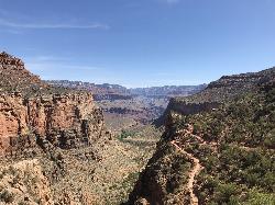
Bright Angel Trail to Three-Mile Rest house
Grand Canyon Village, Arizona
32.4 miles EA steep 5.4-mile out-and-back trail descending into the Grand Canyon with 360-degree canyon views and extreme switchbacks — water and pit toilets at the Three-Mile Resthouse turnaround point.
Backpack, Camp, Hike 4.5 mi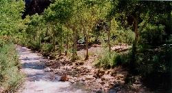
Bright Angel Trail to Bright Angel Campground and River Trail
Grand Canyon Village, Arizona
32.4 miles EThe Bright Angel Trail is the Grand Canyon's most storied hike — South Rim to the Colorado River past tunnels, pictographs, Havasupai Gardens, and the Devil's Corkscrew.
Backpack, Camp, Hike, Rock ClimbNearby Campsites
Havasupai Falls
Supai, Arizona
0.0 miles NWAn eight-mile hike or horseback ride through the remote western Grand Canyon to the village of Supai and Havasupai Falls — accessible only by foot, horse, or helicopter.
Backpack, Camp, Hike
Havasu Falls and Mooney Falls Trail
Supai, Arizona
0.0 miles NEA 12-mile trek into the Havasupai Indian Reservation drops through steep switchbacks and a narrowing canyon to turquoise waterfalls, the Indian town of Supai, and a campground along the creek.
Backpack, Camp, Hike
South Bass Trail
Supai, Arizona
18.6 miles EA strenuous 15.6-mile round-trip remote hike in Grand Canyon with no water at the trailhead, 4,400 feet of descent to the Colorado River, and no established campsites below the rim.
Backpack, Camp, Hike
Tapeats Creek to Deer Creek
North Rim, Arizona
19.8 miles NEA remote Grand Canyon backpacking route connecting Tapeats Creek and Deer Creek Trails — from the Colorado River's trackless beaches to a high trail above Granite Narrows.
Backpack, Camp, Hike
North Bass Trail
North Rim, Arizona
23.4 miles NEA remote North Rim backcountry trail reached via a network of forest service roads, descending to Swamp Point on the Powell Plateau in Grand Canyon NP.
Backpack, Camp, Hike
Powell Plateau Trail
North Rim, Arizona
23.4 miles NEA rewarding plateau-top day hike or backpack to a remote North Rim plateau, where hikers with enough water can wander for days visiting rim overlooks and hidden draws.
Backpack, Camp, Hike
Deer Creek to Colorado River
North Rim, Arizona
24.5 miles NEA scenic Grand Canyon backcountry route leading to Deer Creek and the Colorado River via the Bill Hall Trail — a rewarding wilderness hike in northern Arizona.
Backpack, Camp, Hike
Thunder River and Tapeats Creek Trail
North Rim, Arizona
24.5 miles NEA 25-mile out-and-back hike on the North Rim leading to Thunder River and Tapeats Creek — recommended only for very experienced outdoorsmen and primarily used for hiking and rock climbing.
Backpack, Camp, Hike
Boucher Trail to Hermit Trail Loop
Grand Canyon Village, Arizona
28.6 miles EA demanding 3–4 day backpacking loop on the Grand Canyon's South Rim — even seasoned hikers consider the Boucher Trail the most difficult and hazardous South Rim route.
Backpack, Camp, Hike
Hermit's Rest Viewpoint to Tonto Trail to Bright Angel Trail
Grand Canyon Village, Arizona
28.6 miles EA multi-day Grand Canyon backpacking route crossing the Tonto Trail from Hermit's Rest to Bright Angel — spectacular inner canyon views with limited water sources and 3,000-foot rim access by foot only.
Backpack, Camp, Hike
Hermit Trail
Grand Canyon Village, Arizona
28.6 miles EA strenuous, less-crowded Grand Canyon backpacking trail with 2,000 feet of descent in the first 2.5 miles, Cathedral stairs, Redwall cliffs, and fossilized animal tracks.
Backpack, Camp, Hike 4.9 mi
Bright Angel Trail to Tonto Trail
Grand Canyon Village, Arizona
32.4 miles EA rugged 12.4-mile point-to-point through Grand Canyon's inner gorge on the South Kaibab–Tonto Trail corridor, with over 3,000 feet of elevation gain — advanced hikers only.
Backpack, Camp, Hike
Bright Angel Trail to Three-Mile Rest house
Grand Canyon Village, Arizona
32.4 miles EA steep 5.4-mile out-and-back trail descending into the Grand Canyon with 360-degree canyon views and extreme switchbacks — water and pit toilets at the Three-Mile Resthouse turnaround point.
Backpack, Camp, Hike 4.5 mi
Bright Angel Trail to Bright Angel Campground and River Trail
Grand Canyon Village, Arizona
32.4 miles EThe Bright Angel Trail is the Grand Canyon's most storied hike — South Rim to the Colorado River past tunnels, pictographs, Havasupai Gardens, and the Devil's Corkscrew.
Backpack, Camp, Hike, Rock Climb 1.5-9.8 mi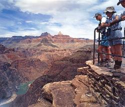
The Bright Angel Trails
Grand Canyon Village, Arizona
32.4 miles EMultiple Bright Angel Trail routes range from a 5.4-mile out-and-back to the Three-Mile Resthouse to a 19-mile trek to the river, with the 12.4-mile South Kaibab–Tonto–Bright Angel point-to-point offering over 3,000 feet of Grand Canyon grandeur.
Backpack, Camp, Hike, Horseback 0.6 mi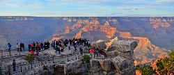
Mather Campground Trail
Grand Canyon Village, Arizona
34.0 miles EA 1-mile connector trail adjacent to Mather Campground on the Grand Canyon South Rim — flat and easy for biking, running, or walking with pets on leash; campground has RV options nearby.
Camp, Hike, Mountain Bike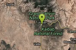
Grand Canyon South Rim Area Campgrounds
Grand Canyon Village, Arizona
35.5 miles ECampgrounds at the Grand Canyon's South Rim, one of the most iconic settings in the American Southwest.
Camp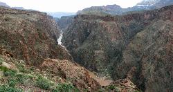
Clear Creek Trail
Grand Canyon Village, Arizona
35.7 miles EA 4–6 day Grand Canyon backpack deep into a fascinating, off-the-beaten-track drainage — bring plenty of water, as Clear Creek is the only reliable source on trail.
Backpack, Camp, Hike 13.6 mi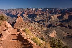
South Kaibab Trails
Grand Canyon Village, Arizona
35.7 miles ESeven miles of ridgeline descent from Yaki Point to the canyon floor — no shade, no water on trail, and the best unobstructed Grand Canyon panoramas you'll find on any hike.
Camp, Hike, Horseback
South Kaibab to Phantom Ranch to Bright Angel Trail
Grand Canyon Village, Arizona
35.7 miles EA difficult but spectacular multi-day Grand Canyon hike combining South Kaibab's stunning rim views with Phantom Ranch's riverside oasis and Bright Angel's shaded water stations.
Backpack, Camp, Hike


