


Refine Search
- hike 38
- mountain bike 27
- horseback 9
- disc golf 6
- swim 5
- rock climb 4
- skateboard 2
- snowshoe 2
- cross-country ski 2
- camp 2
- backpack 2
- sled 1
- kayak 1
- canoe 1
53 locations
Add Location
 Full Listing
Hike, Mountain Bike
Full Listing
Hike, Mountain Bike
 Full Listing
Hike
Full Listing
Hike
 Full Listing
Disc Golf
Full Listing
Disc Golf
 Full Listing
Mountain Bike
Full Listing
Mountain Bike
 Full Listing
Hike, Mountain Bike
Full Listing
Hike, Mountain Bike
 Full Listing
Disc Golf
Full Listing
Disc Golf
 Full Listing
Disc Golf
Full Listing
Disc Golf
 Full Listing
Swim
Full Listing
Swim
 Full Listing
Disc Golf
Full Listing
Disc Golf
 Full Listing
Mountain Bike
Full Listing
Mountain Bike
15.0-18.4 mi
 Full Listing
Backpack, Hike, Horseback
Full Listing
Backpack, Hike, Horseback
Alaska Basin
Driggs, Idaho
10.0 miles E of Driggs, IdahoThe Alaska Basin Trail is a stunning trail through the Jedediah Wilderness near Driggs, Idaho and goes East into Wyoming, just outside of Grand Teton National Park. The trail is wide and has easy terrain for the feet, but it is long, so it's best suited for intermediate to advanced hikers. There are spots on the trail where river crossing is necessary, so be prepared to rock hop, cross logs, or just get your feet wet.
Because the trail is in a wilderness area, rather than a National Park, no overnight camping permits are required; however, open fires are not allowed, so plan on bringing a camping stove. Carry bear spray and, if you are camping, plan on bear proofing your food and waste.
The trail features a variety of landscapes such as lush vegetation and wildflowers (peak season is July to August), rushing rivers and streams, the majestic Teton Mountain Range, and of course, the serene Alaska Basin. There is plenty of wildlife; black bears and moose both have been spotted on the trail. Enjoy their beauty, but please use precaution and respect their territory.
1.0-1.2 mi
 Full Listing
Hike, Rock Climb, Swim
Full Listing
Hike, Rock Climb, Swim
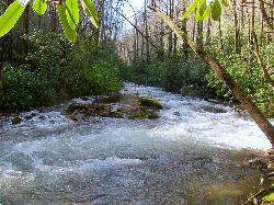
Maiden Pools
Tucson, Arizona
9.3 miles NE of Tucson, ArizonaOver the course of time, the Ventana Stream has exposed the canyon’s base granite, and then smoothed and formed into a series of small pools -- now called the Maiden Pools. With the sounds of trickling water, and the beauty of the desert scenery, this a great spot to relax and enjoy the tranquility of the setting.
To reach Maiden Pools, one can hike up Ventana Canyon trail 2.4 miles. The trail crosses a creek bed several times as it traverses the narrow canyon bottom. The pools can be found on the other side of a steep hill, and will fill after rainfall and snowmelt, making late winter and spring the best time to visit. Alongside the pools are large rocks where one can relax, maybe enjoy a picnic. Some of the pools have oak trees providing both beauty and shade.
Climbing along the rocks will allow access to Ventana Falls, or other pools along the river.
Though the hike is free, there is a $7 park entrance fee. Be sure to bring plenty of water, and keep an eye on the weather to avoid either the extreme summer heat or the risk of flash floods.
3.8 mi
 Full Listing
Hike
Full Listing
Hike
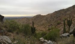
Freedom Loop Trail (#302)
Phoenix, Arizona
6.9 miles NE of Phoenix, ArizonaFreedom Trail (#302), also known as Piestewa Circumference, is a 3.8 mile, moderate loop trail.
You can access this trail from all the inner trailheads. The easiest and least crowded being the Hopi Trailhead. That's the first left after the Ranger Station. The trail takes off in either direction behind the ramada. Heading clockwise you will encounter the summit trailhead in a quick 0.4 miles. Next you will take the summit trail for a half mile. At the 0.6 mile marker on the summit trail take a left onto the circumference route. This is the only left hand turn you take.Courtesy of hikearizona.com
A lot of the trail is very rocky, but still easily manageable. There's some steep elevation gain over two periods of the hike that give you great views, but can be an intense workout depending on your fitness level. Compared to many of the surrounding trails, this is a quieter, more isolated trail that allows you to avoid the crowds, and enjoy the views of residential Phoenix adjacent to the desert vegetation of Saguaros and cacti.
Dogs and Horses are not allowed on the Summit Trail portion of the hike.
1.2 mi
 Full Listing
Hike, Horseback
Full Listing
Hike, Horseback
Ma-Ha-Tauk Trail
Phoenix, Arizona
6.9 miles S of Phoenix, ArizonaMa-Ha-Tauk Trail can be found in South Mountain Park in Phoenix. This is a 2.5 mile, out-and-back trail. Aside from a short section of steeper incline in the first part of the hike, this is an easy trail.
South Mountain Park is located close to town, so Ma-Ha-Tauk is a great trail for a quick trip before work, with younger kids, etc...It's an easy to follow trail, and if you are planning to do additional hikes in South Mountain Park, this trail connects to many others. You can expect views of downtown Phoenix, and the Estrella mountains in the distance.
Dogs are allowed on the trail, however, it is shared with horses, so it's recommended to keep them on a leash.
2.3 mi
 Full Listing
Hike, Mountain Bike
Full Listing
Hike, Mountain Bike
Hidden Valley Trail Via Mormon Trail
Phoenix, Arizona
6.2 miles SE of Phoenix, ArizonaHidden Valley Trail via Mormon Trail is a 2-4 mile hike, depending on the route you choose to take and how much additional exploring you do. This hike offers a natural rock tunnel, petroglyphs, dry waterfalls, Fatman's Pass, and views of South Mountain. This hike can be done year round, but is best enjoyed in the Fall and Winter months to avoid to hot, Arizona sun.
The trail is primarily flat, most of your elevation gain happens in the first mile of the hike, after that it levels out. At about 1.1 miles you'll come to the intersection with the Mormon Loop trail, which is marked and heads off to your left. Don't take that left! Just keep going straight for another few minutes where the Mormon Trail dead-ends into the National Trail. Once you get to this point, you have the options to complete the loop either clockwise or counter-clockwise. (Some suggest that going counter-clockwise is easier to navigate to Hidden Valley Trail.)
Going counter-clockwise, one of the first thing's you will encounter is Fatman's Pass; which is a rock formation that is a narrow crack in a boulder approximately 8 feet high and 15 feet long that you will have to "squeeze through". Fatman's Pass tends to go over well with younger hikers as it gives them a fun area to explore.
After you go through Fatman's Pass, you'll be led to Hidden Valley Trail.
The Valley is about 0.5 mile long and there are numerous trails going through it. You can't really get lost, so just continue down the valley and feel free to follow whichever path suits your fancy. There are lots of little caves/nooks and tunnels to explore in the valley so feel free to take your time exploring. The exit from Hidden Valley is as spectacular as the Fatman's Pass entrance. It consists of a 40 foot natural tunnel through the rock formations, and is also a fun place to spend time exploring.
After exiting the tunnel, continue 50 yards or so to the signed connection to the National Trail. Turn left (West) and follow the National Trail for 0.1 mile to the junction with the Mormon Trail, which you then follow back down to the trailhead. If you didn't enjoy the views while you were huffing and puffing up hill, make sure you enjoy them on the more leisurely descent! Courtesy of hikearizona.com
23.0 mi
 Full Listing
Hike
Full Listing
Hike
Grand Canal Trail
Phoenix, Arizona
3.6 miles NW of Phoenix, ArizonaThe Grand Canal Trail is a 23-mile long system of paved and unpaved trails located in Glendale, Phoenix and Tempe that travels through the middle of the metropolitan area. For most of the way, the trail follows alongside the Grand Canal through residential and business districts. The trail is open for bike riding, walking and running. The route of the trail reduces the number of roadway intersections, but It does have numerous roadway crossings at street level. The trail has gaps at some of the major highways, such as Highway 60 and Interstate 17, but there are underpasses for the Piestewa Freeway, the Red Mountain Freeway and Route 143.Courtesy of walkrideusa.com
The Grand Canal Trail goes past the following points of interest:
University of Phoenix Stadium Alhambra Traditional School Grand Canal Linear Park Steele Indian School Park Glendale Heroes Regional Park Phoenix Advantage Charter School Heatherbrae Elementary School William Machan Elementary School Westland School Creighton Elementary School Maryvale High School Davy Crockett Elementary School Marivue Pool 44th Street & Washington Station Maryvale Stadium Phoenix Sky Harbor International Airport St. Vincent De Paul Catholic School Pueblo Grande Museum & Archaeological Park Glen L. Downs Elementary School Washington Street & Center Parkway Station Justine Spitalny Elementary School The Grand at Papago Park Center Pueblo Del Sol School Tempe Public Park
2.2 mi
 Full Listing
Mountain Bike
Full Listing
Mountain Bike
Pilot Cove / Slate Rocks / 102
Canton, North Carolina
12.4 miles SE of Canton, North CarolinaFun descent with several stream crossings along the way. Nothing too steep but this trail doesn't get a lot of use so there are usually a few trees down along the way. Beautiful scenery and a waterfall along the way. Courtesy of Singletracks.com
3.8 mi
 Full Listing
Cross-country Ski, Hike, Mountain Bike, Snowshoe
Full Listing
Cross-country Ski, Hike, Mountain Bike, Snowshoe
Kelly Mountain Trail
Ririe, Idaho
8.2 miles E of Ririe, IdahoKelly Canyon Trail is a moderate, uphill trail that can be used by hikers, mountain bikers, and ATV riders. The trail features views of hills, mountains, trees, wildflowers, and some wildlife. Dogs are allowed on the trail, but should be kept on a leash.
2.8 mi
 Full Listing
Hike, Mountain Bike
Full Listing
Hike, Mountain Bike
Desert Tortoise
Phoenix, Arizona
20.3 miles N of Phoenix, ArizonaAt just over a mile long, Desert Tortoise is a doubletrack connector to the Valle Verde Trail. Courtesy of MTBProject.com
Very good hiking area with a good range of difficulty levels. Starts with a short climb from the parking lot and some reasonable elevation changes. Back side of loop fairly flat with another slope up to meet Dixie Loop for return. If you bring a dog, it better be very leash controlled due to close proximity of Cholla cactus on trail sides. Observed some Cholla "pears" loose on trail. Good hiker shoes with firm sole recommended due to rockiness. Courtesy of AllTrails.com
3.2 mi
 Full Listing
Hike
Full Listing
Hike
Kinney Creek Trail
Pocatello, Idaho
8.0 miles S of Pocatello, IdahoKinney Creek Trail is in the Caribou-Targhee National Forest near Pocatello. This is a 6.4 out-and-back trail that takes you to the Indian Mountain Summit. It gives you views of Idaho backcountry including trees, wildflowers, and wildlife. This is an ideal spot for birdwatching as it's a place where you can see various species such as: raptors, shorebirds, songbirds, upland birds, waterbirds, waterfowl.
Kinney Creek Trail is best used during the warmer months. Dogs are allowed on the trail.
Holbert-Hidden Valley-Mormon Trail Shuttle
Phoenix, Arizona
6.7 miles S of Phoenix, ArizonaHolbert- Hidden Valley- Mormon Trail is a combination trail hike on the north side of South Mountain near Phoenix, Arizona. This trail is approximately 6.5 miles long, and is suitable for intermediate hikers.
It's a hike that people and kids of all ages can enjoy both from the variety of areas that it encompasses and the length and difficulty range of the hike itself. You get to go from marveling at the Ancient Petroglyphs on the Rocks on the Holbert Trail to the wonderful Rock Playground and Peaceful Solitude of the sparsely traveled Hidden Valley.Courtesy of hikearizona.com
You'll start your trek from the Holbert Trailhead and end at the Mormon Trailhead. As you start, you'll see large rocks featuring petroglyphs around you. Once you get beyond this, you'll see a picnic area, at this point the trail becomes a gradual uphill climb. As the elevation rises, you'll want to be sure to turn around and appreciate the views of the canyon and city behind you. As you near the top of this canyon you will likely encounter more people as you pass Promontory Point, a scenic vista area with a large rock Ramada, with vehicle parking and restrooms.
Soon after that point you will cross Buena Vista Road, you will continue on this path where you will pass Buena Vista Lookout, a parking lot, and 2 other trails. 1.7 miles after the Buena Vista lot you will hit the Hidden Valley Trail Junction. Bear right and down into Hidden Valley. On Hidden Valley Trail you will go through Fatman's Pass; a narrow gap between two giant rocks. Don't worry, the average person can make it through here, but if necessary, you can choose to go over it. This is a cool spot to take pictures, explore, or take a break. Keep on this trail for a little while until you reach the National Trail Junction. When you reach this junction you'll go left and backtrack a little bit on National Trail, which will lead you into Mormon Trail. Once you're on Mormon Trail follow it until you reach the parking lot, and then you've completed this unique and creative hike.
Max Delta
Phoenix, Arizona
6.5 miles S of Phoenix, ArizonaThis trails follows close to San Juan Rd. Part of the trail is rocky while other parts are well just dirt. Courtesy of AllTrails.com
Max Delta Trail is a 2.7 mile trail within Phoenix, Arizona on the South Mountain Preserve. This is an out-and-back trail and it is considered beginner.
The trail has a less than 300 feet elevation gain, so you don't have to huff and puff your way up the trail, but still offers nice views of the Phoenix Valley and Gila Crossing.
What makes this trail unique is that it there was once a mine called the "Max Delta" mine, which, of course, is what the trail is named after. On the trail you can see foundations from structures that once stood on the mountain side, with an old brick fire place that remains standing today.
The Max Delta Mine operated in the early 1900s, supplying massive amounts of Gold, Silver, and Copper. in 1935 Max Delta Mine was the fourth largest producer of gold in the US.Courtesy of placesthatwere.com
The mine is still accessible and has an extensive system of tunnels and train tracks. However, please be aware the hazards of exploring abandoned mines; there are risks of flooding, rusty nails, falling down large drops, and rock collapses. Use caution!
This hike is a cool exploration option, and offers a neat hands on look into the history of the Phoenix area.
Tom Mantsch Disc Golf Course
Hendersonville, North Carolina
7.2 miles W of Hendersonville, North CarolinaVery short and mostly wide open through areas around the baseball fields and the tennis and basketball courts. Public (No Fee)Courtesy of DiscGolfUnited.com
Pink Beds
Pisgah Forest, North Carolina
8.6 miles NW of Pisgah Forest, North CarolinaGreat warm up/cool down trails or beginner trails for Pisgah, as they are mostly flat. The bikeable portion of this trail will dump you out on a gravel road near the South Mills River trail after crossing several creeks along the way. Little technical challenge on these trails, but still great scenery and seclusion.Trail is 3.3 miles one-way. Courtesy of Singletracks.com
South Mills River Trail
Canton, North Carolina
11.7 miles SE of Canton, North CarolinaThis is an easy out-and-back trail that follows the South Fork Mills River with several swinging bridge crossings that leads to the site of the old Cantrell Lodge. From the trail head, the left side trail down to the river is steep and technical. Courtesy of Singletracks.com
Meadowbrook Elementary Disc Golf Course
Canton, North Carolina
1.5 miles S of Canton, North CarolinaSurrounded by the beautiful Southern Appalachians. Long and short tees and dual baskets. A mix open and wooded holes. Primarily for students but open to the public after school (5pm) and on weekends. Be respectful of any other school activities and of the school grounds. Public (No Fee)Courtesy of DiscGolfUnited.com
Mars Hill College Disc Golf Course
Mars Hill, North Carolina
0.2 miles W of Mars Hill, North CarolinaExcellent views, drastic elevation, tricky greens, manicured grass fairways, wooded holes and mandatories. Pack out trash. Alcohol illegal. Please be respectful. Public (No Fee)Courtesy of DiscGolfUnited.com
North Mills River
Mills River, North Carolina
4.8 miles W of Mills River, North CarolinaThe forest is known for its hiking and mountain biking trails, several of which are near the campground. Mills River offers excellent trout fishing, as well as tubing and swimming, which are kid-friendly favorite activities. Visitors wishing to learn more about the area can attend educational programs during the summer.Courtesy of recreation.gov
Black Mountain Disc Golf
Black Mountain, North Carolina
1.0 miles SW of Black Mountain, North CarolinaIn a small park near a winding creek and scenic area. Relatively short but technical. Front 9 is links style - the back 9 have more length. Dual tees. Moderate poison ivy. Public (No Fee)Courtesy of DiscGolfUnited.com
Middle Fork
Horse Shoe, North Carolina
7.8 miles NW of Horse Shoe, North CarolinaThis trail is about 8.8 miles of fire road and 2.6 miles of singletrack. There are 2 gated roads from the trailhead take the one on the right, Fletcher Creek Road (AKA The Never Ending Road). It starts out gravel road then goes to doubletrack. You'll past Spencer Branch Trail around 4.5 miles, then Fletcher Creek Trail. The road will start to become very untraveled and remote feeling with the road becoming over grown. Around 8 miles Middle Fork Trail will be on your left. The trail has a little of everything, small drops, log jams, rock gardens, bogs and multible creek crossings. At 2.4 miles turn right on Fletcher Creek Trail then cross a creek and the Spencer Branch Trail. Continue on Fletcher Creek Trail it will dump you out on Hendersonville Reservoir Road. Turn left back to the Trailhead or right to Hendersonville Reservoir for a break. It is a very nice spot for lunch. If you want to spice up the ride turn right on Spencer Branch Trail. You will walk some of this if your not a Pro. It will dump you out at the Reservoir. Courtesy of Singletracks.com
×


