


Refine Search
- hike 38
- mountain bike 27
- horseback 9
- swim 6
- disc golf 6
- rock climb 5
- camp 2
- backpack 2
- skateboard 2
- cross-country ski 2
- snowshoe 2
- sled 1
- kayak 1
- hot springs 1
- canoe 1
55 locations
Add Location
 Full Listing
Hike
Full Listing
Hike
 Full Listing
Hike
Full Listing
Hike
 Full Listing
Hike
Full Listing
Hike
 Full Listing
Hike, Mountain Bike
Full Listing
Hike, Mountain Bike
 Full Listing
Hike, Mountain Bike
Full Listing
Hike, Mountain Bike
 Full Listing
Hike, Horseback, Mountain Bike
Full Listing
Hike, Horseback, Mountain Bike
 Full Listing
Hike, Horseback, Mountain Bike
Full Listing
Hike, Horseback, Mountain Bike
 Full Listing
Hike, Mountain Bike
Full Listing
Hike, Mountain Bike
 Full Listing
Hike, Mountain Bike
Full Listing
Hike, Mountain Bike
 Full Listing
Hike, Mountain Bike
Full Listing
Hike, Mountain Bike
 Full Listing
Disc Golf, Swim
Full Listing
Disc Golf, Swim
 Full Listing
Skateboard
Full Listing
Skateboard
 Full Listing
Skateboard
Full Listing
Skateboard
 Full Listing
Camp, Swim
Full Listing
Camp, Swim
 Full Listing
Backpack, Camp, Canoe, Cross-country Ski, Hike, Kayak, Mountain Bike, Sled, Snowshoe, Swim
Full Listing
Backpack, Camp, Canoe, Cross-country Ski, Hike, Kayak, Mountain Bike, Sled, Snowshoe, Swim
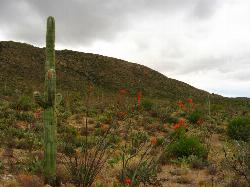
Telegraph Pass Trail
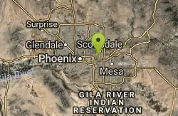
Phoenix, Arizona
9.0 miles S of Phoenix, ArizonaTelegraph Pass Trail is a 2.3 mile beginner friendly, out-and-back trail in South Mountain Park in Phoenix.
The first third or so of Telegraph Trail is paved, making it wheelchair accessible. The paved section ends around the area of some petroglyphs marked with an interpretive sign off to the right. The trail veers left at this point, and becomes unpaved, but still clearly marked. The hike is a steady climb, but nothing too bad, however there is little shade, so be sure to pace yourself and bring plenty of water. The trail ends at mile 1.15, where you can turn back and return to the trailhead, or you have the option to continue onto National Trail.
Along the trail you can see saguaros which are the most notable desert vegetation, views of the metropolitan Phoenix area, and the rest of South Mountain Park.
Crosscut Canal Trail
Tempe, Arizona
1.6 miles N of Tempe, ArizonaCrosscut Canal Trail is a concrete, sidewalk multi-use trail for walking, biking, wheelchairs, scooters, and skateboards. This two mile long path follows a canal and links Tempe Town Lake to Papago Park.
At the intersection of East McDowell, turn left on the path and head south. If you are traveling from the north you’ll reach Papago Park through a tunnel under McDowell. In front of you are the red buttes of Papago Park. Just over the ridge, you’ll find many attractions, like the Botanical Gardens, the Phoenix Zoo, Hunt's Tomb and Hole-in-th Rock.
As you continue south at Evelyn Hallman Park the trail you lead you to the canal resevior and dam. The canal's reservoir is hidden in the Papago Buttes. Birds and ducks nest on its shore. Here at the reservoir, the highest point on the trail, you look out over central Phoenix, the ASU campus, Tempe Town Lake and South Mountain.
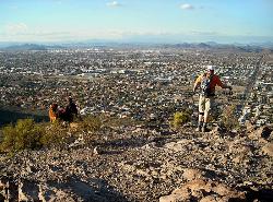
Lookout Mountain Summit Trail
Phoenix, Arizona
12.4 miles N of Phoenix, ArizonaLookout Mountain Summit Trail is a short, 1 mile trail in Phoenix, Arizona. The trail is steep, especially towards the summit, but it's manageable, and well worth the views.
There is parking at the end of 16th street, with a small parking lot; there is typically a light but constant stream of traffic on the trails during the week but parking is not usually a problem until the weekend. Just off the parking lot is the trailhead. The trail is marked well until you get towards the top. People have created lots of trails so choosing the right one can be difficult. Just keep going up and you will reach the summit. The trail is rocky, and has loose gravel, so bring good hiking shoes, especially for sections at the top where it gets steep and slippery.
Lookout Mountain is located in the middle of residential Phoenix, so the summit features stunning views of the surrounding city, complimented with views of mountains and desert in the distance.
Inspiration Point
Scottsdale, Arizona
11.4 miles N of Scottsdale, ArizonaInspiration Point is a 5.7, moderate hike located on the McDowell Sonoran Preserve near Scottsdale, Arizona.
You'll begin your hike at the Gateway area, where you can find a parking lot and bathrooms. Start on the Saguaro trail which leads to the Gateway loop trail, you can go left or right, left will be shorter, right will be longer; this trail connects with the Windgate Pass Trail, Inspiration Point can be found on this trail. It's roughly a 1,000 ft. elevation gain.
The trails are rocky, but well-maintained, and clearly marked. The path winds up to a bench overlooking the city-filled valley and around to another bench that is surrounded by other peaks and valleys filled with nature. Inspiration Point is less traveled than Gateway loop, which is always crowded and is a popular tourist/family hike, thus Inspiration is a more quiet and secluded spot to enjoy the beauty of the scenery.
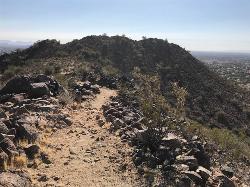
Arrowhead Point Trail
Glendale, Arizona
11.0 miles N of Glendale, ArizonaArrowhead Trail is a 2.4 mile hiking and mountain biking trail within Thunderbird Conservation Park. This trail is manageable enough for beginners, but offers enough challenge for more experienced hikers and bikers.
Arrowhead Trail is easiest accessed by way of Whip Trail. The trail is rocky, with several switchbacks, and a decent mix of steeper terrains and more shallow, even sections. About 1 mile into the hike, a top a summit there is an American Flag that flows, surrounded by the views of the desert valley and mountain peaks on the horizon, this is a great picture spot. A half mile further from that spot there is a ramada style shelter spot with picnic tables, where you can rest and enjoy a snack or drink.
The most rugged of the Thunderbird Park trails, this trail has typical Sonoran Flora, including Saguaro, Barrel, Cholla, and Buckhorn Cactus, along with Palo Verde, Creosote, Brittlebush and Perennials depending on rainfall. I've seen a number of Coyotes over the years, as well as some nice lizards.Courtesy of hikearizona.com
The parking lot is locked and closed from sunset to sunrise. This is a pet friendly trail, but it gets a fair amount of traffic, so it's encouraged to keep your pets leashed.
Rainbow Valley to Toothaker Loop Trail
Goodyear, Arizona
4.6 miles S of Goodyear, ArizonaEstrella Mountain Regional Park has many trails within it, a great beginner to intermediate friendly trail is the Rainbow Valley to Toothaker Loop Trail. This 6.6 mile hike is mostly flat with a few steep sections on the Rainbow Valley Trail.
The trailhead for both the Rainbow Valley and Toothaker Hiking Trails is located across from the park’s Rodeo Arena. Starting the loop on the Rainbow Valley Trail, the first 3/4-mile of the hike crosses a shallow valley, as it works its way towards the park’s northern hills.
For the next mile and a half, the path winds flatly along the sides of these hills. Scenic views of Goodyear, its airport and the distant peaks of the White Tank Mountains span generously to the north. At about 2.5 miles, the Rainbow Valley Trail gently descends the hillsides, crosses a soft sandy wash, and begins to curve back towards the heart of the park.
The views shift graciously from suburban vistas to stretches of flat desert rimmed by distant purple mountains. Ascending between two hills, the path steepens for a bit as it continues winding into the park’s interior. A tall, boulder laden crest marks the highest point of the Rainbow Valley and Toothaker Hiking Trail Loop. From the top of the boulders, lengthy views of the Estrella Mountain’s undulating interior hills stretch in every direction From this point on the Rainbow Valley and Toothaker Hiking Trail Loop mildly descends and then evens out.
The Rainbow Valley Trail ends at a T-intersection with the Toothaker. Turning left, the path remains flat as it moves along the side of a deeply carved wash.
With the exception of one brief wash crossing, the Rainbow Valley and Toothaker Hiking Trail’s last two miles are easy and even, moving across the valley floor. Occassional mountain bikers should be expected as the trail is shared usage and ideal riding territory.Courtesy of azutopia.com
Note: There is a $6 entry fee for Estrella Mountain Regional Park.
Dixie Mountain Loop Trail
Phoenix, Arizona
20.3 miles N of Phoenix, ArizonaThe main loop trail at Phoenix's Sonoran Preserve provides plenty of options for either a short walk or a longer hike. The elevation gain is accumulated through small ups-and-downs along the trail. Look for the Teddy Bear Cholla forest between mile posts 2.6 and 2.75. The Sonoran Preserve is located in the transition zone to the Arizona Upland, which has higher amounts of rainfall than other Phoenix area hikes, increasing both the lushness and diversity of plant life. Courtesy of AllTrails.com
Located just off of I-17, in the Phoenix Sonoran Preserve, you can find the Dixie Mountain Loop Trail. This is a 4.7 mile, well marked trail that is considered beginner to moderate. This hike starts on the south end of the mountain, and take you around to the northern side. Along the way, you'll get great views in every direction of surrounding Dove Valley, with wildflowers, cactus, and the Teddy Bear Cholla Forest. Within the loop, you can find access to two different summits to the highest peaks on the Preserve. The trail is open and exposed, so bring plenty of water and sun pretection.
There is plenty of parking, but no bathrooms on site. This is a pet friendly trail.
Brittlebush Trail
Phoenix, Arizona
39.8 miles SW of Phoenix, ArizonaBrittlebush trail is a flat, 12-mile round trip, out-and-back trail in the heart of the Maricopa Wilderness. It's best used from November - April, and should be avoided in the Summer months due to the lack of shade, and its remote location.
The path passes between two low rocky hills, then bends left to skirt another hill, before heading cross country through the creosote flats towards the mountains. The trail looks like an old road in this section. After a bit of walking, the trail reaches the mountains and enters a wide sandy wash (note: you will skirt a prominent mountain just to the right, if you look closely you may see some circular faded petroglyphs on the burnished rock of this hill, please do not disturb). After following the wash for a while, you will come to a brown plastic 'Trail' sign on the left. The path bends left at this point and climbs up into the desert, becoming easy to follow once again. The trail winds its way through the desert for a while, then drops down a short rocky hill into a wash (6 miles). This wash is the Margies Cove Trail. If you have another car spotted at the east or west entrances, turn right or left respectively, otherwise, return the way you came (12 miles).
Sunrise Mountain Trail
Peoria, Arizona
10.3 miles N of Peoria, ArizonaThe Sunrise Mountain Trail can be found within the suburban area of Peoria, Arizona; it is made of up 3 sequential loops; each loop harder than the last.
The trail is easy to find, as it starts from Westwing park, Peoria (where you can find restrooms annd water), then look for a large rock with map at the trailhead about 150 yds south of the parking lot.
Although this hike does have areas of leveled paths, it includes a significent level of incline and decline, however, there are plenty of spots to take breaks as needed. Along the trail you'll see gorgeous views of the cities of Glendale, Peoria, and Phoenix, as well as the surrounding mountains and desert vegetation.
In a few places along the way you'll experience forks in the trail, but regardless of the direction you choose you'll stay on the trail. It will be very clear if you've reached the end of a spur trail, as the trail will seem to disappear in front of you. Simply turn around to rejoin the main trail.Courtesy of hikingproject.com
Sunrise Mountain Trail is pet friendly. The trail is closed from sundown to sunrise.
Cactus Forest Trail
Tucson, Arizona
12.1 miles E of Tucson, ArizonaPart of the approximately 10-mile Cactus Forest Trail runs through Saguaro National Park East and provides a nice landscape introduction for newcomers to the desert. A 2.5 mile dirt trail that bisects the Cactus Forest Loop Drive in East Saguaro. The park has designated the Cactus Forest Trail as multi-use and welcomes both horses and bicycles.
This flat, dirst trail is in excellent condition. On both sides, you can see a vast array of cacti, from old giant saguaro to much smaller cholla.The Rincon Mountains loomed to the east, providing a majestic backdrop to the scene.
This easy 2-mile round-trip walk would likely be suitable for children. But simply going along the trail for a short way gives a nice up-close look at what the desert here has to offer. Hiking boots are not needed.
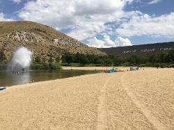
Sandy Point
Boise, Idaho
9.9 miles SE of Boise, IdahoSandy Point is a beach within Lucky Peak State Park, located 8 miles southeast of Boise, Idaho. It feautures a small lake with a several amenities.
The lake is mostly shallow, and cool, but not too cold, making it an ideal spot for families. In the middle of the eastern area of the lake, there is a big fountain that you can swim, paddleboard, or float to to play in or enjoy a refreshing, cool mist. On the bank of the eastern part of the lake there is a splash pad area inthe shallow water, for children,with smaller fountain structures. Free life jackets are available on site. The beach is sandy but the floor of the lake contains many rocks, so it may be a good idea to wear protective shoes.
The lake is surrounded by a park area with plenty of trees to provide shade, picnic tables and grills, flushing bathrooms and a changing area, disc golf, volleyball courts, as well as a rental and concession spot where you can buy various snacks and beverages, and rent paddleboards by the half hour or hour.
The southwestern edge of the park is a little further from parking and tends to be slightly quieter as it is further from the activity of children enjoying the fountain area.
It's best to visit Sandy Point in the spring and summer. Dogs are not allowed in Sandy Point, but are allowed in nearby Discovery Park and Spring Shores. It's suggested to call the park at (208) 334-2432 for questions about park hours and fees.
Etnies Skate Park Lake Forest
Lake Forest, California
2.3 miles NE of Lake Forest, CaliforniaIf you want to skate this park is a must.Requirements to skate: Signed waiver form, membership form and valid skate park I.D. For riders under the age of 18 parents must be present to sign the waiver form to be witnessed by Skatepark Staff or The waiver and membership form can be notarized. Faxed forms will not be accepted. Helmet, Kneepads, Elbow pads required at all times while in the park. Park Regulations: Helmet, Kneepads, Elbow pads required at all times while in the park. Failure to wear protective gear is grounds for removal from Skatepark All park users must have a completed and signed waiver form, member ship form and valid skatepark I.D.on file. No unauthorized pieces of equipment obstacles or apparatus may be brought into the skate area. Skatepark will be closed during inclement weather. Spectators are not permitted within the skate area. Participants under the age of 8 must have a guardian with them at the park at all times. No Razors, Heelies, or any other type of activity besides skateboarding, roller-skating, or inline skating is allowed. Only bottled water is allowed on the skate able area; no food, sodas or sports drinks allowed. Skatepark staff reserves the right to close the park or change the hours of operation with out prior notice. Courtesy of skatepark.com
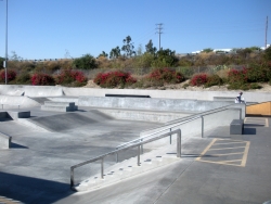
Krause Family Skate Park
San Diego, California
6.5 miles N of San Diego, CaliforniaWith brand new rails, jump boxes, gaps, quarter pipes, and skate light, our park is a blast to skate and bike! Here at the park we strive to provide a fun and positive environment for children and adults to come and enjoy their need for extreme sports. Many professional athletes practice here almost daily, but this park is open and available for people of all ages and skills to enjoy. Our facilities include a concrete pool, beginner course, mini-ramp, intermediate course, advanced BMX course, and a vert ramp; all on a 50,000 sq. ft. lot. There is so much to enjoy! So pad up and get on over to the park! Courtesy of skatepark.com
Porcupine Creek
Ashton, Idaho
11.4 miles E of Ashton, IdahoPorcupine Creek is a hunting, fishing, camping, and swimming spot near Ashton, Idaho in Fremont County within Targhee National Forest. It's surrounded by forests, meadows, and a creek that you can explore and see various wildlife. There are trails nearby, however, none of them are marked trails. There's a few good spots to camp right here by a stream, but be aware that it is bear country, so use precaution and pack your food properly, or use the provided metal storage areas in the campsites.
Note: Porcupine Creek is closed to the public from November - March to protect wintering wildlife.
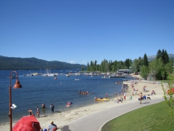
Mccall Area
McCall, Idaho
10.4 miles NE of McCall, IdahoMcCall is a beautiful resort town located in western Idaho, two hours north of Boise. It's feautures a multitude of activity of activities in both the Winter and Summer months, including: swimming, hiking, camping, biking, kayaking, canoeing, backpacking, snowshoeing, skiing, and sledding.
Summer Activities:
- Beautiful and cold swimming holes in the forests around McCall. For details...Courtesy of swimmingholes.org
- Box Lake Trail: this is an moderate - advanced, 7 mile, out-and-back trail. The first hour or so of the trail has steep terrain. The trail leads to an isolated lake with gorgeous views. This trail is dog friendly.
- Pondersosa State Park: just east of the Payette Lake, Ponderosa State Park features a myriad of an activities. There are hikes for all skill levels; some of the most well-known are Meadow Marsh trail, Lily Marsh trail, both are shorter trails, great for families with children. The Ponderosa State Park Big Loop is a more moderate trail that spans 6 miles in its entirety. The park also has several mountain biking trails such as the Peninsula biking trail, Fox Run biking trail, and Huckleberry Bay biking trail. On some of these trails you can find huckleberry bushes that are free for the picking. Additionally, there are many places to camp and picnic within the park.
- Payette Lake: a beautiful spot to swim, boat, kayak, canoe, paddleboard, or sit and enjoy the scenery.
Winter Activities:
- Ponderosa State Park: the trails in this park transition from hiking trails in Summer to nordic skiiing and snowshoeing trails in Winter.
- McCall Winter Carnival:
During Carnival, enjoy famous snow sculptures, Torchlight and Mardi Gras Parades, live music, daily events spanning everything from comedy shows to art auctions, snowbike races to the Monster Dog Pull and much more. Courtesy of mccallchamber.org
×


