


1.1K Portfolio Arenas by nicole97
first prev 1 next lastThe following Arena locations are places which I have researched and written about during my internship for freearenas.com.

Pineview Reservoir
Eden, Utah
0.8 miles SW of Eden, UtahLocated on the backside of the Wasatch Front, Pineview Reservoir in the Ogden River Canyon is home to stunning views of the water, sandy beaches, the Southern Skyline trail, paved ramps, and campgrounds thus providing a great location for recreational activities of many kinds. Popular activities include boating, canoeing, fishing, horseshoe, kayaking, paddle boarding, picnicking, swimming, volleyball, wakeboarding, and water skiing.
The reservoir is a vastly popular location for fishing tiger muskie and is great for experiencing the picturesque beauty of nature. The three swimming areas are Cemetery Point (west of Huntsville), Anderson Cove campground, and Middle Inlet Beach (north of Huntsville). Shade is scarce so be sure to bring your own canopy or cover during hot summer months as well as wear sun protection. The beaches tend to be busy on weekends.
The out-and-back Southern Skyline trail totals 18.2 miles in distance and is located between the highway and reservoir perfect for walking, biking, and riding dirt bikes. The trail initially commences with a slight uphill climb which increases as the trail progresses. Be cautious and courteous to wildlife including snakes. The campground gates are locked each night at 10 p.m. and are reserved on a first come, first served basis.

Antelope Island State Park
Syracuse, Utah
10.0 miles SW of Syracuse, UtahLocated just 41 miles north of Salt Lake City, Antelope Island State Park encompasses a vast selection of outdoor activities and spectacular scenery providing a peaceful nature experience. Experience stunning 360-degree views as you drive around the State Park or try other activities such as exploring the roughly 20 miles of trails open for hiking, biking, and running or horseback riding. Picnic tables and designated campsites are available though RV hookups are not provided.
Enjoy the water as you kayak, fish, sail, or swim off of the Great Salt Lake’s largest island. Wild animals such as antelope, birds, bison, bobcats, coyotes, deer, and horned sheep roam freely and claim Antelope Island home. Watching the wildlife is a must. Be sure to take caution around wildlife and keep your distance. Do not touch or feed wildlife.
Absorb the beauty of nature through spectacular sunrises, sunsets, and the spectacular night sky. The Visitor Center includes publications, restrooms, and exhibits for all to enjoy. The best times of year for exploring Antelope Island are early spring an late fall. Beware of the bug situation in late spring and early summer. Bug spray is mandatory. Don't forget to bring drinking water as well to stay hydrated during your adventures.

Jenny Lake Trail
Jackson Hole, Wyoming
19.7 miles N of Jackson Hole, WyomingOne of the most popular trails to visit in Grand Teton is the Jenny Lake Trail. The Jenny Lake Trail, located near Moose, Wyoming, is an easy trail that loops around the lake. Along with the sheer beauty of Jenny Lake and surrounding mountains, some of the main attractions on this hike are Hidden Falls and Inspiration Point.
The trail underwent significant changes in 2018 after a fissure opened up and rock slides became an issue. The temporary changes made at that time, including trail reroutes and closures, have been undone and the lower trail is now open again taking onlookers all the way to Hidden Falls once again. The trail has been well built including hundreds of nicely placed stone stairs that keep the trail solid and provide great footing where you need it most.
Wildlife is common on the trails, including plenty of chipmunks, marmots, moose, deer, elk, and even an occasional bear. The best spot to see a moose or bear is often the overlook down to the Moose Pond Trail. You'll see a sign for the trail off to the left just a little ways before you get to the overlook. Even if you don't see any wildlife there though, the view of the ponds and Teewinot rising above is worth taking a break for. Other than this little jaunt over to the overlook and the hike up to Hidden Falls and Inspiration Point, the trail follows along the river for most of the way making any break you take a picturesque scene to enjoy.
The sunrise and sunset at Jenny Lake are incredible with radiant colors and exciting reflections off the water. Take a dip in Jenny Lake to cool off during summer months but remember that this is pretty fresh snow runoff so it may be colder than you think. For a little warmer swim, check out String Lake just to the North.
Between the soaring Tetons above, the falls above the trail, the raging river below the trail, and the expansive view of the lake and valley, there are plenty of great views to take in whether you see any wildlife or not.
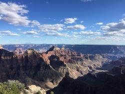
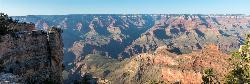
Bright Angel Point Trail
North Rim, Arizona
1.2 miles S of North Rim, ArizonaLocated at the North Rim of the Grand Canyon, the Bright Angel Point Trail is a steep, narrow, fully paved path leading to an incredible scenic viewpoint. The trail is conveniently located right next to the Grand Canyon Lodge and is only a short hike from the North Rim Visitor’s Center.
This trail encompasses stunning views from all angles and features numerous large rocks. These rocks are perfect for sitting on to relax and observe the beauty of the Canyon while also can be climbed for even more gorgeous views. The scenery constantly changes as you walk down the path and are stunning to look out upon as you return.
Keep the kiddos close as the adventure begins downhill with steep drop-offs on both sides. The steepness on the way out makes returning a bit more strenuous but is still very doable for all hiking levels. Large rocks and trees line both sides of the path for a good portion of the trail which is much less crowded than the South Rim.
Toward the end of the trail, you cross a small bridge which may seem scary, yet has guardrails conveniently placed both on the bridge as well as near the point in order to provide safety.
While the light reflecting off the Canyon appears to be flat around mid-day, Bright Angel Point is a marvelous place to watch the sunrise or sunset and experience dynamic reflections of incredible colors. The remarkable views make Bright Angel Point the most popular destination for photography at the North Rim.
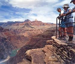
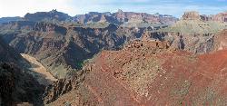
Hermit's Rest Viewpoint to Tonto Trail to Bright Angel Trail
Grand Canyon Village, Arizona
4.0 miles W of Grand Canyon Village, ArizonaHermit’s Rest Viewpoint to Tonto Trail to Bright Angel Trailhead is perfect for hiking, backpacking, walking, and trail running. The Trail takes you across a well-established portion of the Tonto Trail and provides spectacular views of the river, the inner canyon, as well as the inner gorge rim. This adventure is commonly accomplished as a several day backpacking trip.
Accessing the Tonto Trail cannot be done by driving to the beginning of the trail, rather, must be found on foot as it is below the rim 3,000 feet. The terrain of the Tonto Trail is not well-maintained but rather rough and full of erosion. The inner canyon is a wilderness route which is full of narrow sections. Hiking in these areas is both mentally and physically taxing.
The majority of this trail does not have water access so be sure to bring plenty of your own. There are three water sources for hikers to utilize located between Bright Angel Trail and the Hermit Trail. Indian Garden, Monument Creek and just below the Tonto Trail crossing are locations which do provide purified water. Another option for water is Hermit Creek but is one mile off the path to access. Permits are required for overnight camping below the rim.
The Bright Angel Trails
Grand Canyon Village, Arizona
0.3 miles NW of Grand Canyon Village, Arizona- Prepare yourself for switchbacks as part of a tough elevation gain on the Bright Angel trail to Plateau Point trail. This trail features spectacular views as you hike along the edge of Arizona’s Grand Canyon and brings you to incredible views of the Colorado River. Ranger station access is available at the Indian Garden campground as it is quite difficult.
- Bright Angel Trail to Bright Angel Campground and River dirt trail is one of the most famous trails near Grand Canyon, Arizona. The well-maintained trail encompasses incredible views and has an elevation gain of 5029 feet. The campground features picnic tables. The route is 19 miles one way and is an out and back.
- The South Kaibab Trail Tonto Trail to Bright Angel point-to-point Trail is 12.4 miles in distance with over 3,000 feet in elevation gain offering fantastic views of the Grand Canyon. The Tonto Trail is over 70 miles of rough terrain only suggested for advanced hikers.
- The popular out-and-back Bright Angel Trail to Three-Mile Resthouse is 5.4 miles out in distance. The trail includes many steep switchbacks and 360 degrees of absolutely stunning views of the inside of the canyon. The Bright Angel trail will take you from Grand Canyon village down to the Three-Mile Resthouse. The challenging up-hill return will likely take you twice as long as the steep descent. The narrow trail takes you right down the canyon with sheer cliffs up above you. Be sure to pace yourself as the elevation changes are abrupt in this Grand Canyon terrain. The trail condition varies depending on the time of year, therefore, it is important to prepare for shadeless extreme heat in the summer and icy patches in winter months. There is water available on the trail so be sure to bring bottles to fill up. Pit toilets, covered shelter, and drinking water are all available at the Resthouse.
The Bright Angel Trail connects to:
- Plateau point
- Mile-and-a-half resthouse
- Indian garden
- River resthouse
- Bright Angel campground (via the river trail)
- Phantom Ranch
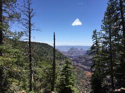
Widforss Trail
North Rim, Arizona
0.8 miles NW of North Rim, ArizonaWidforss Trail overlooks the Grand Canyon as it leads along the beautiful North Rim. The peaceful forested trail features numerous picture perfect locations from the beginning of the trail on over to Widforss Point. You will find incredible Canyon views, lovely rocks, and fantastic forest trees.
The trail is well maintained, easy to follow, and typically not crowded. The trail is shaded for a large portion of the hike but still can be very hot. It has uphill inclines as well as dips and weaves in and out of the woods but does not require any climbing in order to accomplish. The trail provides several opportunities for hikers to sit on rock ledges to absorb the remarkable views. Great for hiking, trail running and backpacking. On average the 10-mile trek takes roughly 4 to 5 hours.
There is a pit toilet at the trailhead parking lot but no water sources along the way so be sure to pack water. There is an informational paper provided at the North Rim Visitors Center which corresponds with the trail. This paper points out specific areas to take note of and educate you about the area’s ecology and geology as you adventure along the trail.
Rim Trail
Grand Canyon Village, Arizona
3.1 miles E of Grand Canyon Village, ArizonaThe Rim Trail is approximately 12 miles in length and is packed full of incredible Grand Canyon views. The majority of the path is paved and is more of a walking than hiking trail and is great for kids. This mostly flat path is popular for tourists as it provides shaded areas, fantastic views, and only moderate climbs with the option to walk as long or short of a distance as you wish. There is a wheelchair and stroller accessible path provided.
The best time to see prime views of the Grand Canyon are during what is referred to as the golden hours which is the hour immediately following sunrises and prior to sunsets. Water sources can be found in Grand Canyon Village and at Hermits Rest but are not provided along the trail so be sure to bring plenty of water along. The Rim Trail is great for finding scenic viewpoints and breathtaking overlooks, exceptionally perfect for capturing great images of the Grand Canyon.
The Grand Canyon shuttle is a popular element of this trail. The shuttle stops and goes providing numerous locations from which hikers can select which areas they wish to get off experience in more depth. Pets on leashes are not allowed on any shuttle buses but are welcomed along the trail.
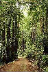
Pescadero Creek Trail Area
Loma Mar, California
1.1 miles E of Loma Mar, CaliforniaPerfect for all redwood lovers, the Pescadero Creek Park area is an incredible shady trail for a hike on a hot summer day. This is a great place to escape from city sounds and enjoy the peace of nature. Pescadero Creek Park, a San Mateo County park complex trail system, is interconnected as it encompasses Memorial Park, Heritage Grove Park, Sam McDonald Park, and Portola Redwoods State Park. Though, officially, access to the extensive trail system starts on the eastern end of Wurr Road just off Pescadero Road.
The trails are roughly an hour away from the Bay Area and each varies in level of difficulty. The trails encompass select redwood country featuring ridges, hills, rolling meadows, and valleys. Watch out for poison oak and don't forget the mosquito repellant. Equestrian and bicycles are permitted, refer to the park rangers for information about trail conditions as well as designated service roads. Motorized vehicles are prohibited in areas which are not paved.
Even though it is located is close to the ocean, the Pescadero Creek Trail Area is typically not busy and is always absolutely stunning to visit. Wild pigs can be spotted along the road. Be aware that the trails can sometimes be more difficult to find so plan accordingly.

Farmington Canyon
Farmington, Utah
0.9 miles N of Farmington, UtahFarmington Canyon is a gorgeous location to explore during all four seasons of the year, but the prime months for visiting are April through October. The dusty Skyline Drive long is along a gravel road and very bumpy to drive up. It is closed for cars during the winter months. The road connects Farmington to Bountiful thus providing access to Francis Peak, Bountiful Peak as well as the Smith Lakes.
The colors of the leaves within the canyon are incredibly vibrant throughout the year, especially in autumn. Farmington Canyon is a great place to take a bumpy yet beautiful car ride, to go camping, trail running or enjoy a scenic walk. The Farmington Creek Trail includes rocks to climb over as well as stream crossings and does not have much shade covering. Farmington Canyon provides an incredible view of Kaysville and the Great Salt Lake.
The Sunset campground, composed of 16 sites, is located on the Farmington side, 3.6 miles from the pavement is on the ridge of the canyon. Located further up the canyon is the Bountiful Peak campground which has 21 sites. Located at the bottom of the canyon is Farmington Pond which is another place to visit and includes picnic tables and a paved trail.
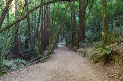
East Ridge Trail
Oakland, California
6.9 miles E of Oakland, CaliforniaThis trail is deeply tucked away up into the hills of Oakland. East Ridge is the perfect trail to deeply appreciate the beauty of the Redwoods and has many entry points. This trail weaves through grassy meadows and over ridges and steep slopes. This trail has shady parts and will lead you to the falls.
This trail on this hike is wide, even and gentle. This hike is accessible to all hikers that want to enjoy it. This trail winds steeply down to the valley floor and after rain, can be very slippery. Hikers that hike at a normal, relaxed pace, can complete this loop in about 2-3 hours. If speed is your thing, trails are equally ideal for trail running.
This hike is accessible all year round. This trail is exposed and can be pretty hot and dusty in the summer. During the rainy seasons, trails can be slippery and muddy after rain. During the winter season, keep your eye out for the massive clusters of ladybugs that migrate to the park’s trees each winter along the park’s coast redwoods.
Dogs must be leashed if you take them on this hike. The main entrance, Redwood Gate, charges a $5 parking fee during peak season. The park is opens at 5am and closes at 10pm. So if you like hiking or running at the crack-of-dawn or would prefer going after work, you can enjoy the trail and facilities.
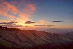
Grizzly Peak Trail
Berkeley, California
2.1 miles NE of Berkeley, CaliforniaGrizzly Peak Trail is located near La Loma Park in the Berkeley Hills section of the city of Berkeley, California and leads to an incredible lookout of the San Francisco Bay area. Driving up Grizzly Peak Road there are many spectacular places to pull over to take photos. This is a great hike to take out-of-town guests or tourists to go on, and it can be done on the way to or from Oakland/Berkeley.
Many runners have said that this trail is great for running and that the peak is a great place to stop and enjoy the view. If you choose to run to the peak and back, it would be about a 1-mile run, roundtrip. If you want to run the whole trail, it would be a little over 2 miles. This trail is dog-friendly, however, you should keep your dog on a leash. This hike is the best and most beautiful when done on a clear day, so be sure to check the weather the day before your hike.
The peak can be climbed almost year round because its elevation is relatively low. During periods of recent snowfall, it may be best to avoid the peak because of the ice and snow. Snow doesn't last too long on the peak, usually melting off most of the routes within a few days of snow. In the height of summer, temperatures may be too warm for an enjoyable climb.
The peak was named because of the Grizzly bears inhabiting the area until the late 1880s. The last grizzly in all of California was killed in the Sierra foothills east of Fresno in August 1922.
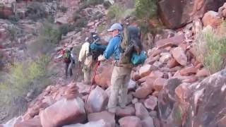
South Kaibab to Phantom Ranch to Bright Angel Trail
Grand Canyon Village, Arizona
3.2 miles E of Grand Canyon Village, ArizonaOne of the most popular hikes in Grand Canyon National Park is the South Kaibab to Phantom Ranch to Bright Angel Trail. Marked as difficult, the trail is well maintained and labeled. This Grand Canyon trail features breathtaking views, animals, rushing water, plants, animals, stunning rock layers and formations of mountains. Both the Bright Angel Trail and the Kaibab have unique components and views.
Be sure to only attempt this hike if you are in good physical and mental condition to do so. Be prepared for high altitude, intense heat or cold elements on this hike by wearing the right clothing, taking care of your body and getting a good nights sleep prior to going. Don't forget hiking poles as well as your camera in order to enhance your experience.
The trail contains many rocks, areas of sand, holes in the ground and steep areas. The final three miles of switchbacks are very difficult. It is important to stay hydrated by drinking plenty of water and electrolytes. There isn't any shade on the South Kaibab trail but the Bright Angel does have shade in the afternoon hours. Water stations are provided at various points along the Bright Angel trail, at Phantom Ranch as well as at Indian Garden.
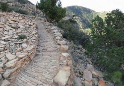
Hermit Trail
Grand Canyon Village, Arizona
4.0 miles W of Grand Canyon Village, ArizonaThe Grand Canyon's Hermit Trail is a scenic beauty which begins at the end of Hermit Road. The rocky trail is well-marked and less busy than the Bright Angel and North Kaibab trails. While possible, the hike isn’t typically accomplished in a single day. Backpacking this trail is common. The hike can be very strenuous and is for experienced individuals. Water can be obtained at the Santa Maria Spring but it does require filtration of some kind. Bring plenty of water for exploring this trail.
Long traverses up against the south rim walls provide plenty of shade. There are several Cathedral stairs, sharp drops, and rocky switchbacks which you experience as you travel through the Redwall cliffs of the trail. Hikers may frequently hear loud noises from helicopters. The Canyon’s rocks and views of the sky are breathtaking. Watch closely and you'll find fossilized animal tracks throughout the Canyon.
The first section of the trail takes you down 2000 feet within the first two and a half miles. After passing the Waldron Trail junction near the Hermit Shale's bottom, pass the Dripping Springs Trail junction and be sure to remain on the right at both junctions so you can see Hermit Creek gorge. Beyond the Hermit Creek campsite, the Hermit Trail extends one and a half more miles over to the Colorado River and large Hermit Rapids.


