


The Bright Angel Trails
Grand Canyon Village, Arizona
| Address: | ~223-225 Village Loop Drive, Grand Canyon Village, AZ 86023, USA |
| GPS: |
36°3'27.4"N 112°8'36.8"W Maps | Directions |
| State: | Arizona |
| Trail Length: | 12.30 miles |
| Trail Type: | Out & Back |
| Hike Difficulty: | Advanced |
| Elevation Gain: | 3188 feet |
| Trails/Routes: | 1.4-9.8 mi |
Restrooms Rivers Rocks Wildflowers Pet Friendly National Park
Backpack, Camp, Hike, and Horseback
- Prepare yourself for switchbacks as part of a tough elevation gain on the Bright Angel trail to Plateau Point trail. This trail features spectacular views as you hike along the edge of Arizona’s Grand Canyon and brings you to incredible views of the Colorado River. Ranger station access is available at the Indian Garden campground as it is quite difficult.
- Bright Angel Trail to Bright Angel Campground and River dirt trail is one of the most famous trails near Grand Canyon, Arizona. The well-maintained trail encompasses incredible views and has an elevation gain of 5029 feet. The campground features picnic tables. The route is 19 miles one way and is an out and back.
- The South Kaibab Trail Tonto Trail to Bright Angel point-to-point Trail is 12.4 miles in distance with over 3,000 feet in elevation gain offering fantastic views of the Grand Canyon. The Tonto Trail is over 70 miles of rough terrain only suggested for advanced hikers.
- The popular out-and-back Bright Angel Trail to Three-Mile Resthouse is 5.4 miles out in distance. The trail includes many steep switchbacks and 360 degrees of absolutely stunning views of the inside of the canyon. The Bright Angel trail will take you from Grand Canyon village down to the Three-Mile Resthouse. The challenging up-hill return will likely take you twice as long as the steep descent. The narrow trail takes you right down the canyon with sheer cliffs up above you. Be sure to pace yourself as the elevation changes are abrupt in this Grand Canyon terrain. The trail condition varies depending on the time of year, therefore, it is important to prepare for shadeless extreme heat in the summer and icy patches in winter months. There is water available on the trail so be sure to bring bottles to fill up. Pit toilets, covered shelter, and drinking water are all available at the Resthouse.
The Bright Angel Trail connects to:
- Plateau point
- Mile-and-a-half resthouse
- Indian garden
- River resthouse
- Bright Angel campground (via the river trail)
- Phantom Ranch
Mapped Route/Trail Distances
| Bright Angel to Plateau Point | 6.1 miles |
| Indian Garden from Bright Angel Trail | 4.6 miles |
| Bright Angel to One-and-a-Half Mile Resthouse | 1.4 miles |
| Bright Angel to Tonto Trail | 5.1 miles |
| Bright Angel to Bright Angel Campground | 9.5 miles |
| Bright Angel to Phantom Ranch | 9.8 miles |
More Information
Be courteous, informed, and prepared. Read trailhead guidelines, stay on the trail, and don't feed the wildlife.
Read More- Plan Ahead and Prepare
- Travel & camp on durable surfaces
- Dispose of waste properly
- Leave what you find
- Minimize campfire impacts
- Respect wildlife
- Be considerate of other visitors
Directions
From Grand Canyon Village, Arizona
- Head west (344 ft)
- Turn right toward Village Loop Drive (141 ft)
- Turn right onto Village Loop Drive (0.4 mi)
- Turn left to stay on Village Loop Drive (0.4 mi)
- Turn right (105 ft)
- Turn leftDestination will be on the left(348 ft)
- The hike to Plateau Point commences with the Bright Angel Trailhead. To reach the Bright Angel trailhead, located west of the Bright Angel Lodge you have two options, either park at Lot D at the Backcountry Information Center and walk 5 minutes to the trailhead, or park at the Grand Canyon Visitor Center and catch the free shuttle bus (:20 minutes one way). Courtesy of the National Park Service.
- To reach the Bright Angel trailhead, located west of the Bright Angel Lodge you have two options, either park at Lot D at the Backcountry Information Center and walk 5 minutes to the trailhead, or park at the Grand Canyon Visitor Center and catch the free shuttle bus (:20 minutes one way). Courtesy of the National Park Service.
- An Express shuttle will deliver you to the South Kaibab trailhead from the Bright Angel Lodge bus stop.
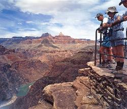
 Plateau Point View courtesy of Michael Quinn - National Park Service↗

 Bright Angel Trail - Plateau Point courtesy of Mrmcdonnell↗
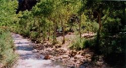
 Tents at Bright Angel campground courtesy of Grand Canyon Association↗
 Bright Angel campground courtesy of Bob Ribokas↗
 Grand Canyon National Park: The Tonto Trail courtesy of Michael Quinn - National Park Service↗
 The Tonto Trail courtesy of Michael Quinn - National Park Service↗
 Tonto Platform courtesy of brewbooks↗


Trails
Distance ?
6.1 milesElevation Gain ?
-3,312 feetReal Ascent ?
848 feetReal Descent ?
4,160 feetAvg Grade (-6°)
-11%Grade (-59° to 41°)
-164% to 88%Distance ?
4.6 milesElevation Gain ?
-2,999 feetReal Ascent ?
636 feetReal Descent ?
3,635 feetAvg Grade (-7°)
-13%Grade (-53° to 41°)
-132% to 86%Distance ?
1.4 milesElevation Gain ?
-1,091 feetReal Ascent ?
331 feetReal Descent ?
1,422 feetAvg Grade (-8°)
-15%Grade (-55° to 35°)
-143% to 70%Distance ?
5.1 milesElevation Gain ?
-3,130 feetReal Ascent ?
682 feetReal Descent ?
3,812 feetAvg Grade (-7°)
-12%Grade (-59° to 41°)
-164% to 88%Distance ?
9.5 milesElevation Gain ?
-4,319 feetReal Ascent ?
1,728 feetReal Descent ?
6,047 feetAvg Grade (-5°)
-9%Grade (-59° to 41°)
-164% to 88%Distance ?
9.8 milesElevation Gain ?
-4,272 feetReal Ascent ?
1,778 feetReal Descent ?
6,050 feetAvg Grade (-5°)
-8%Grade (-59° to 41°)
-164% to 88%Elevation differences are scaled for emphasis. While the numbers are accurate, the cut-away shown here is not to scale.
Other Hiking Trails, Horseback Trails, and Backpacking Trails Nearby
Bright Angel Trail to Bright Angel Campground and River Trail
Grand Canyon Village, Arizona
0.0 miles SWBright Angel Trail to Bright Angel Campground and River dirt trail is one of the most famous trails near Grand Canyon, Arizona. The well-maintained trail encompasses incredible views and has an...
Backpack, Camp, Hike, Rock Climb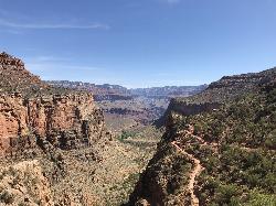
Bright Angel Trail to Three-Mile Rest house
Grand Canyon Village, Arizona
0.0 miles SWThe popular out-and-back Bright Angel Trail to Three-Mile Resthouse is 5.4 miles out in distance. The trail includes many steep switchbacks and 360 degrees of absolutely stunning views of the inside...
Backpack, Camp, Hike 4.9 mi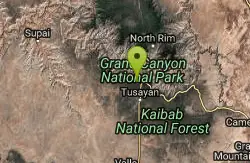
Bright Angel Trail to Tonto Trail
Grand Canyon Village, Arizona
0.1 miles SW"[T]he Tonto Trail offers a degree of civility not found elsewhere along the trail, and it is here that most hikers get their first exposure to the unique nature of this singular transcanyon...
Backpack, Camp, Hike 8.4 mi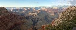
Grand Canyon Rim Village to Hermits Rest
Grand Canyon Village, Arizona
0.1 miles SWGrand Canyon Rim Village to Hermits Rest is a bus accessible trail featuring stunning river views, wildlife, and wildflowers. This kid-friendly trail is perfect for hiking, backpacking, trail...
Backpack, Hike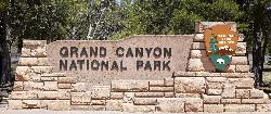
South Rim Visitor Center Trail
Grand Canyon Village, Arizona
0.9 miles ELocated near the South Rim Visitor Center of Grand Canyon National Park, this Trail is well-marked to provide a useful path for where you need to go. The trail is a connector from the Visitor Center...
Hike 0.6 mi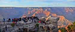
Mather Campground Trail
Grand Canyon Village, Arizona
1.6 miles SELocated on the South Rim of the Grand Canyon, Mather Campground Trail is a brief one mile out and back connector trail which is great for hiking, mountain biking, walking, and trail running. The...
Camp, Hike, Mountain Bike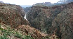
Clear Creek Trail
Grand Canyon Village, Arizona
3.3 miles EAn extended backpack trip of four to six days deep within the Grand Canyon. NOTE: The starting point for Clear Creek Trail, Bright Angel Campground, is in a remote location away from a trailhead. The...
Backpack, Camp, Hike 13.6 mi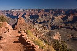
South Kaibab Trails
Grand Canyon Village, Arizona
3.3 miles ESouth Kaibab Trail is a 7 mile point-to-point trail located near Grand Canyon, Arizona that features a river and is rated as difficult. The trail is primarily used for hiking & walking and is...
Camp, Hike, Horseback 5.7 mi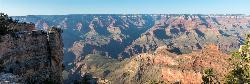
Rim Trail
Grand Canyon Village, Arizona
3.4 miles EThe Rim Trail is approximately 12 miles in length and is packed full of incredible Grand Canyon views. The majority of the path is paved and is more of a walking than hiking trail and is great for...
Hike, Mountain Bike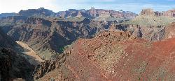
South Kaibab to Phantom Ranch to Bright Angel Trail
Grand Canyon Village, Arizona
3.4 miles EOne of the most popular hikes in Grand Canyon National Park is the South Kaibab to Phantom Ranch to Bright Angel Trail. Marked as difficult, the trail is well maintained and labeled. This Grand...
Backpack, Camp, Hike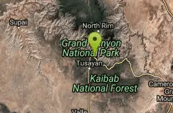
South Kaibab to North Kaibab to Bright Angel Trail
Grand Canyon Village, Arizona
3.4 miles EGenerally an early morning start and a late finish with an amazing sunrise on the way down the South Kaibab and depending on your speed, a beautiful sunset as you hike back toward (or up) Bright...
Backpack, Camp, Hike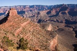
The Grand Canyon: Kaibab to Bright Angel Trail
Grand Canyon Village, Arizona
3.4 miles EExperience the Grand Canyon like few others with this unforgettable 2-3 day trip down into the canyon. If you are looking for the perfect hike in the Grand Canyon, this is it. The 2 (or 3) day hike...
Backpack, Camp, Hike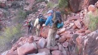
Hermit Trail
Grand Canyon Village, Arizona
3.8 miles WThe Grand Canyon's Hermit Trail is a scenic beauty which begins at the end of Hermit Road. The rocky trail is well-marked and less busy than the Bright Angel and North Kaibab trails. While...
Backpack, Camp, Hike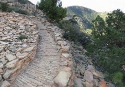
Hermit's Rest Viewpoint to Tonto Trail to Bright Angel Trail
Grand Canyon Village, Arizona
3.8 miles WHermit’s Rest Viewpoint to Tonto Trail to Bright Angel Trailhead is perfect for hiking, backpacking, walking, and trail running. The Trail takes you across a well-established portion of the...
Backpack, Camp, Hike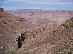
Boucher Trail to Hermit Trail Loop
Grand Canyon Village, Arizona
3.8 miles WA demanding loop trip of three to four days, tracing one of the most difficult South Rim trails. Even seasoned Grand Canyon backpackers consider the Boucher Trail to be the most difficult, hazardous,...
Backpack, Camp, Hike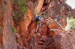
Boucher Trail
Grand Canyon Village, Arizona
3.8 miles WBoucher Trail is a 17.7 mile moderately trafficked out and back trail located near Grand Canyon, Arizona that features a river and is only recommended for very experienced adventurers. The trail is...
Backpack, Hike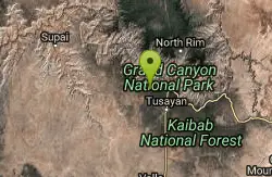
Hermit's Rest Viewpoint to Santa Maria Spring
Grand Canyon Village, Arizona
3.8 miles WLocated in Grand Canyon National Park, Hermit’s Rest Viewpoint to Santa Maria Spring trail features fantastic views in a peaceful setting. The trail is easy to follow as it is well maintained...
Backpack, Hike 7.7 mi
Waldron Trail
Grand Canyon Village, Arizona
3.9 miles WAn alternative to the highly strenuous Hermit Trail, the Waldron Trail splits off from the Hermit Trail 1.2 miles in and is one of the shorter trails in the canyon at only 2 miles long. Open...
Hike
Hermits Rest Viewpoint to Dripping Springs Trail
Grand Canyon Village, Arizona
3.9 miles WThe Dripping Springs and Hermit Trail out and back contains incredible views. Once you have passed Dripping Springs there are no trail markings so be sure to know exactly where you are at. The trail...
Backpack, Hike 1.1 mi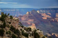
Shoshone Point Trail
Grand Canyon Village, Arizona
4.4 miles EShoshone Point Trail is a non-marked trail for hikers of all skill levels. The trail has limited views until the Shoshone Point overlook past the picnic area where astonishing canyon...
HikeNearby Campsites
Bright Angel Trail to Bright Angel Campground and River Trail
Grand Canyon Village, Arizona
0.0 miles SWBright Angel Trail to Bright Angel Campground and River dirt trail is one of the most famous trails near Grand Canyon, Arizona. The well-maintained trail encompasses incredible views and has an...
Backpack, Camp, Hike, Rock Climb
Bright Angel Trail to Three-Mile Rest house
Grand Canyon Village, Arizona
0.0 miles SWThe popular out-and-back Bright Angel Trail to Three-Mile Resthouse is 5.4 miles out in distance. The trail includes many steep switchbacks and 360 degrees of absolutely stunning views of the inside...
Backpack, Camp, Hike 4.9 mi
Bright Angel Trail to Tonto Trail
Grand Canyon Village, Arizona
0.1 miles SW"[T]he Tonto Trail offers a degree of civility not found elsewhere along the trail, and it is here that most hikers get their first exposure to the unique nature of this singular transcanyon...
Backpack, Camp, Hike 0.6 mi
Mather Campground Trail
Grand Canyon Village, Arizona
1.6 miles SELocated on the South Rim of the Grand Canyon, Mather Campground Trail is a brief one mile out and back connector trail which is great for hiking, mountain biking, walking, and trail running. The...
Camp, Hike, Mountain Bike
Clear Creek Trail
Grand Canyon Village, Arizona
3.3 miles EAn extended backpack trip of four to six days deep within the Grand Canyon. NOTE: The starting point for Clear Creek Trail, Bright Angel Campground, is in a remote location away from a trailhead. The...
Backpack, Camp, Hike 13.6 mi
South Kaibab Trails
Grand Canyon Village, Arizona
3.3 miles ESouth Kaibab Trail is a 7 mile point-to-point trail located near Grand Canyon, Arizona that features a river and is rated as difficult. The trail is primarily used for hiking & walking and is...
Camp, Hike, Horseback
South Kaibab to Phantom Ranch to Bright Angel Trail
Grand Canyon Village, Arizona
3.4 miles EOne of the most popular hikes in Grand Canyon National Park is the South Kaibab to Phantom Ranch to Bright Angel Trail. Marked as difficult, the trail is well maintained and labeled. This Grand...
Backpack, Camp, Hike
South Kaibab to North Kaibab to Bright Angel Trail
Grand Canyon Village, Arizona
3.4 miles EGenerally an early morning start and a late finish with an amazing sunrise on the way down the South Kaibab and depending on your speed, a beautiful sunset as you hike back toward (or up) Bright...
Backpack, Camp, Hike
The Grand Canyon: Kaibab to Bright Angel Trail
Grand Canyon Village, Arizona
3.4 miles EExperience the Grand Canyon like few others with this unforgettable 2-3 day trip down into the canyon. If you are looking for the perfect hike in the Grand Canyon, this is it. The 2 (or 3) day hike...
Backpack, Camp, Hike
Hermit Trail
Grand Canyon Village, Arizona
3.8 miles WThe Grand Canyon's Hermit Trail is a scenic beauty which begins at the end of Hermit Road. The rocky trail is well-marked and less busy than the Bright Angel and North Kaibab trails. While...
Backpack, Camp, Hike
Hermit's Rest Viewpoint to Tonto Trail to Bright Angel Trail
Grand Canyon Village, Arizona
3.8 miles WHermit’s Rest Viewpoint to Tonto Trail to Bright Angel Trailhead is perfect for hiking, backpacking, walking, and trail running. The Trail takes you across a well-established portion of the...
Backpack, Camp, Hike
Boucher Trail to Hermit Trail Loop
Grand Canyon Village, Arizona
3.8 miles WA demanding loop trip of three to four days, tracing one of the most difficult South Rim trails. Even seasoned Grand Canyon backpackers consider the Boucher Trail to be the most difficult, hazardous,...
Backpack, Camp, Hike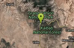
Grand Canyon South Rim Area Campgrounds
Grand Canyon Village, Arizona
6.1 miles SCamp
Grandview Trail Loop
Grand Canyon Village, Arizona
9.6 miles SEThis is definitely not a mountain biking trail! I am a resident of Grand Canyon and know for sure. Also use of Mtn bikes on canyon trails is illegal in the Park....
Backpack, Camp, Cross-country Ski, Hike
Tonto Trail from Grandview Point to South Kaibab Trailhead
Grand Canyon Village, Arizona
9.7 miles SEA rigorous point-to-point backpack of four to five days; recommended for experienced Grand Canyon backpackers only. Long stretches of this scenic, lonely segment of the Tonto Trail are...
Backpack, Camp, Hike
North Kaibab Trail to Colorado River
North Rim, Arizona
12.0 miles NEThe North Kaibab Trail to Colorado River Trail is perfect for experienced hikers. The trail contains many elevation changes and is very steep. The trail is well maintained and well marked so you can...
Backpack, Camp, Hike
Phantom Ranch to Ribbon Falls on North Kaibab Trail
North Rim, Arizona
12.0 miles NECamp, Hike
Rim-to-Rim: North to South Kaibab Trail
North Rim, Arizona
12.0 miles NEArizona Office of Tourism, 2702 N. 3rd St., Suite 4015 , Phoenix, AZ, 85004, Phone: 888-520-3434, Fax: 602-240-5432, mfioritt@pni.com
Camp, Hike, Horseback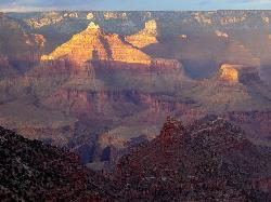
Rim-to-Rim: North Kaibab to Grand Canyon Village
North Rim, Arizona
12.0 miles NEFour days across the Grand Canyon you will never forget! There is a secret to a Grand Canyon rim-to-rim hike: Take four days to do it, even if you can do it in one. I have friends who go South to...
Backpack, Camp, Hike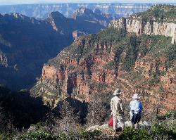
Uncle Jim Trail
North Rim, Arizona
12.1 miles NEDirections from North Rim Entrance: Drive southward along North Rim Drive to the North Kaibab Trailhead. Turn left into the parking area and locate the trailhead on the eastern side of the lot.
Backpack, Camp, Hike


