


Refine Search
- hike 48
- backpack 23
- camp 21
- mountain bike 9
- horseback 9
- swim 6
- disc golf 4
- skateboard 2
- kayak 2
- rock climb 2
- cave 1
- whitewater 1
- canoe 1
57 locations
Add Location
 Full Listing
Hike
Full Listing
Hike
 Full Listing
Backpack, Camp, Hike
Full Listing
Backpack, Camp, Hike
 Full Listing
Hike
Full Listing
Hike
 Full Listing
Backpack, Camp, Hike
Full Listing
Backpack, Camp, Hike
 Full Listing
Backpack, Hike
Full Listing
Backpack, Hike
 Full Listing
Backpack, Camp, Hike
Full Listing
Backpack, Camp, Hike
 Full Listing
Backpack, Camp, Hike
Full Listing
Backpack, Camp, Hike
 Full Listing
Backpack, Camp, Hike
Full Listing
Backpack, Camp, Hike
 Full Listing
Hike
Full Listing
Hike
0.3-5.1 mi
 Full Listing
Hike
Full Listing
Hike
Jenny Lake Trail
Jackson Hole, Wyoming
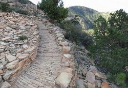
19.7 miles N of Jackson Hole, WyomingOne of the most popular trails to visit in Grand Teton is the Jenny Lake Trail. The Jenny Lake Trail, located near Moose, Wyoming, is an easy trail that loops around the lake. Along with the sheer beauty of Jenny Lake and surrounding mountains, some of the main attractions on this hike are Hidden Falls and Inspiration Point.
The trail underwent significant changes in 2018 after a fissure opened up and rock slides became an issue. The temporary changes made at that time, including trail reroutes and closures, have been undone and the lower trail is now open again taking onlookers all the way to Hidden Falls once again. The trail has been well built including hundreds of nicely placed stone stairs that keep the trail solid and provide great footing where you need it most.
Wildlife is common on the trails, including plenty of chipmunks, marmots, moose, deer, elk, and even an occasional bear. The best spot to see a moose or bear is often the overlook down to the Moose Pond Trail. You'll see a sign for the trail off to the left just a little ways before you get to the overlook. Even if you don't see any wildlife there though, the view of the ponds and Teewinot rising above is worth taking a break for. Other than this little jaunt over to the overlook and the hike up to Hidden Falls and Inspiration Point, the trail follows along the river for most of the way making any break you take a picturesque scene to enjoy.
The sunrise and sunset at Jenny Lake are incredible with radiant colors and exciting reflections off the water. Take a dip in Jenny Lake to cool off during summer months but remember that this is pretty fresh snow runoff so it may be colder than you think. For a little warmer swim, check out String Lake just to the North.
Between the soaring Tetons above, the falls above the trail, the raging river below the trail, and the expansive view of the lake and valley, there are plenty of great views to take in whether you see any wildlife or not.
0.1 mi
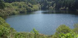
Bass Lake
Bolinas, California
5.2 miles NW of Bolinas, CaliforniaHike and Swim near Bolinas, California
Full Listing
Hike, Swim
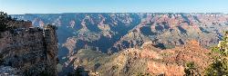
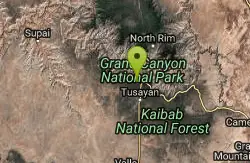
Roosevelt Point Trail
North Rim, Arizona
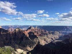
5.9 miles E of North Rim, ArizonaRoosevelt Point Trail on Grand Canyon National Park's North Rim is a 0.2 mile short, relatively flat woodland loop trail offering spectacular views. Roosevelt Point Trail on Grand Canyon National Park's North Rim is a short, relatively flat 0.2 mi. woodland loop offering spectacular views; 20 minutes approximate round-trip hiking time. Offers benches for relaxed enjoyment of the canyon. Fires in recent years have taken out many of the trees leaving smaller brush and open areas. Good views of Tritle Peak and surrounding canyon areas. Courtesy of AllTrails.com
7.7 mi
 Full Listing
Hike
Full Listing
Hike
Waldron Trail
Grand Canyon Village, Arizona
4.1 miles W of Grand Canyon Village, ArizonaAn alternative to the highly strenuous Hermit Trail, the Waldron Trail splits off from the Hermit Trail 1.2 miles in and is one of the shorter trails in the canyon at only 2 miles long. Open year-round, this intermediate-level trail begins at the Hermit Trail junction and is packed with great views and opportunities for adventure. Plenty of wildlife can be found along this trail, but interacting with them is highly discouraged and, in most cases, prohibited entirely. Water availability is extremely limited along this trail and, despite being an extremely short path, it’s recommended that hikers come prepared for hazards like dehydration, unpredictable and severe weather including flash flooding, and overexertion. Water treatment kits are a popular alternative to bringing bottled water, and if you plan on hiking all the way to the Colorado River, you’ll need that water treatment kit to drink from it. Courtesy of explorethecanyon.com
Waldron Trail is a 4.9 mile lightly trafficked out and back trail located near Grand Canyon, Arizona and is rated as difficult. The trail is primarily used for hiking and trail running and is accessible year-round. Courtesy of alltrails.com
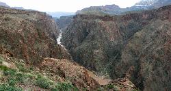
Clear Creek Trail
Grand Canyon Village, Arizona
3.1 miles E of Grand Canyon Village, ArizonaAn extended backpack trip of four to six days deep within the Grand Canyon. NOTE: The starting point for Clear Creek Trail, Bright Angel Campground, is in a remote location away from a trailhead. The shortest, fastest way to Bright Angel Campground is from the South Kaibab trailhead following the South Kaibab Trail. The Road to Yaki Point and the South Kaibab trailhead is closed to private vehicles. Therefore, hikers must ride the free Kaibab Trail Route Shuttle bus, which departs every fifteen minutes from Canyon View Information Plaza. Carry plenty of water for the long trek to Clear Creek - the only reliable water on the trail. Clear Creek is a fascinating, off-the-beaten-track destination that deserves several days to explore. Courtesy of AllTrails.com
Transept Trail
North Rim, Arizona
1.2 miles S of North Rim, ArizonaThe 3.4 mile out and back Transept Trail connects Grand Canyon Lodge to the North Rim Campground, follows the rim of a side canyon called the Transept, and offers a relaxing yet moderate hike with great rim views just off the path. The 3.4 mile out and back Transept Trail connects Grand Canyon Lodge and Visitor Center to the North Rim Campground and follows the rim of a side canyon called the Transept. Although not paved, this easy to moderate trail takes you through Quaking aspens, Gamble Oaks and ponderosa pines, making a very relaxing walk to and from the campground. The trail passes an ancestral Puebloan ruin at about midway to the campground which appears as a line of rocks looking like a trail offshoot. There are several hills with a modest slope. The views here of the Grand Canyon's North Rim aren't quite as expansive as in other places but you can still access some nice cliff areas. Courtesy of AllTrails.com
0.5-0.8 mi
 Full Listing
Hike
Full Listing
Hike
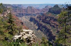
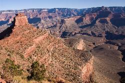
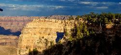
Cape Royal Trail
North Rim, Arizona
8.7 miles SE of North Rim, ArizonaCape Royal is a long peninsula extending from the North Rim out over the Grand Canyon. It offers a phenomenal view, perhaps the most sweeping view of any Grand Canyon vista. Take the short stroll to the end of the cape and to the promontory on the window. It's an easy walk less than a mile RT on a flat, paved trail providing views of the canyon, Angels Window, and the Colorado River. Markers along the trail interpret the area's natural history. Trail begins at the southeast side of the Cape Royal parking area. With seemingly unlimited vistas to the east and west, it is popular for both sunrise and sunset. The sweeping turn of the Colorado River at the Unkar Delta is framed through the natural arch of Angels Window. Look for the Desert View Watchtower across the canyon on the South Rim. Angels Window can be viewed from Angels Window Overlook at the Cliff Springs Trailhead. The trailhead parking area is at the end of the paved Cape Royal Road, which circles northeast and then south from the main road leading to North Rim VC and lodge. Courtesy of AllTrails.com
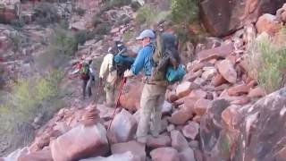
Boucher Trail to Hermit Trail Loop
Grand Canyon Village, Arizona
4.0 miles W of Grand Canyon Village, ArizonaA demanding loop trip of three to four days, tracing one of the most difficult South Rim trails. Even seasoned Grand Canyon backpackers consider the Boucher Trail to be the most difficult, hazardous, and challenging trail in the South Rim. The trip begins at Hermit Road which is closed to private vehicles March 1 through November 30. During this time a free shuttle bus offers access to Hermits Rest every 15 and 30 minutes from about 5:15 am to sunset each day. You can board the shuttle bus at Hermits Rest Transfer shuttle bus stop. Courtesy of AllTrails.com
Boucher Trail
Grand Canyon Village, Arizona
4.0 miles W of Grand Canyon Village, ArizonaBoucher Trail is a 17.7 mile moderately trafficked out and back trail located near Grand Canyon, Arizona that features a river and is only recommended for very experienced adventurers. The trail is primarily used for hiking, trail running, and backpacking and is best used from March until October. Courtesy of alltrails.com
Hermit's Rest Viewpoint to Tonto Trail to Bright Angel Trail
Grand Canyon Village, Arizona
4.0 miles W of Grand Canyon Village, ArizonaHermit’s Rest Viewpoint to Tonto Trail to Bright Angel Trailhead is perfect for hiking, backpacking, walking, and trail running. The Trail takes you across a well-established portion of the Tonto Trail and provides spectacular views of the river, the inner canyon, as well as the inner gorge rim. This adventure is commonly accomplished as a several day backpacking trip.
Accessing the Tonto Trail cannot be done by driving to the beginning of the trail, rather, must be found on foot as it is below the rim 3,000 feet. The terrain of the Tonto Trail is not well-maintained but rather rough and full of erosion. The inner canyon is a wilderness route which is full of narrow sections. Hiking in these areas is both mentally and physically taxing.
The majority of this trail does not have water access so be sure to bring plenty of your own. There are three water sources for hikers to utilize located between Bright Angel Trail and the Hermit Trail. Indian Garden, Monument Creek and just below the Tonto Trail crossing are locations which do provide purified water. Another option for water is Hermit Creek but is one mile off the path to access. Permits are required for overnight camping below the rim.
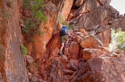
Hermit Trail
Grand Canyon Village, Arizona
4.0 miles W of Grand Canyon Village, ArizonaThe Grand Canyon's Hermit Trail is a scenic beauty which begins at the end of Hermit Road. The rocky trail is well-marked and less busy than the Bright Angel and North Kaibab trails. While possible, the hike isn’t typically accomplished in a single day. Backpacking this trail is common. The hike can be very strenuous and is for experienced individuals. Water can be obtained at the Santa Maria Spring but it does require filtration of some kind. Bring plenty of water for exploring this trail.
Long traverses up against the south rim walls provide plenty of shade. There are several Cathedral stairs, sharp drops, and rocky switchbacks which you experience as you travel through the Redwall cliffs of the trail. Hikers may frequently hear loud noises from helicopters. The Canyon’s rocks and views of the sky are breathtaking. Watch closely and you'll find fossilized animal tracks throughout the Canyon.
The first section of the trail takes you down 2000 feet within the first two and a half miles. After passing the Waldron Trail junction near the Hermit Shale's bottom, pass the Dripping Springs Trail junction and be sure to remain on the right at both junctions so you can see Hermit Creek gorge. Beyond the Hermit Creek campsite, the Hermit Trail extends one and a half more miles over to the Colorado River and large Hermit Rapids.
1.1 mi
 Full Listing
Hike
Full Listing
Hike
Shoshone Point Trail
Grand Canyon Village, Arizona
4.2 miles E of Grand Canyon Village, ArizonaShoshone Point Trail is a non-marked trail for hikers of all skill levels. The trail has limited views until the Shoshone Point overlook past the picnic area where astonishing canyon views can be seen. Perfect for kids.
The Shoshone Point Trail starts at a gate and unsigned parking pullout just west of mile marker 246 on Desert View Drive. The quiet trail is a nearly level dirt road that gains only 100 feet over its mile length. Cross the plateau hiking through a wooded area covered with ponderosa pine. After a mile, emerge at the turn around a loop where there are benches, grills, mule hitching posts and pit toilets. The covered pavilion can be rented for events, but you don't need a permit just to visit the overlook. The views of the eastern Grand Canyon area from the rim here are great, but thrill seekers press on to the very edge of Shoshone Point. Be careful with the loose rock and narrow ledges, a fall would be deadly. Check out the cool mushroom/headstone rock formation at the point. See if you can identify Hance Rapids, Desert View Tower, Vishnu Temple, Horseshoe Mesa and many other landmarks. Enjoy the solitude of this unpopulated gem, then retrace your steps back to the parking area. This is also a popular place to watch the sunset (bring a headlamp for the hike back). Courtesy of hikingproject.com
The Grand Canyon: Kaibab to Bright Angel Trail
Grand Canyon Village, Arizona
3.2 miles E of Grand Canyon Village, ArizonaExperience the Grand Canyon like few others with this unforgettable 2-3 day trip down into the canyon. If you are looking for the perfect hike in the Grand Canyon, this is it. The 2 (or 3) day hike will take you down into the canyon to where few visitors have the privilege of going. Although the Bright Angel trail is not as steep and has more shade cover and water, the views from the South Kaibab trail are unbeatable. It is best to start from the South Kaibab, hike down to the Bright Angel campground, and back up the Bright Angel trail. This way you get a change of scenery and can hike up where there is more available water. If you have a few more days to spare, you can spend another night at the Bright Angel campground (there are some good day hikes from there), or spend a night at Indian Garden on the way back up to the Rim. However long you stay, it will be an experience to remember for a long time, as there is no better way to see the Grand Canyon that by staring up at it from the river below. Courtesy of AllTrails.com
4.9 mi
 Full Listing
Backpack, Camp, Hike
Full Listing
Backpack, Camp, Hike
Bright Angel Trail to Tonto Trail
Grand Canyon Village, Arizona
0.3 miles NW of Grand Canyon Village, Arizona"[T]he Tonto Trail offers a degree of civility not found elsewhere along the trail, and it is here that most hikers get their first exposure to the unique nature of this singular transcanyon route." Courtesy of nps.gov
The South Kaibab Trail Tonto Trail to Bright Angel point-to-point Trail is 12.4 miles in distance with over 3,000 feet in elevation gain overing fantastic views of the Grand Canyon. The Tonto Trail is over 70 miles of rough terrain only suggested for advanced hikers.
South Rim Visitor Center Trail
Grand Canyon Village, Arizona
0.8 miles E of Grand Canyon Village, ArizonaLocated near the South Rim Visitor Center of Grand Canyon National Park, this Trail is well-marked to provide a useful path for where you need to go. The trail is a connector from the Visitor Center on over to a restaurant located near the end of the path and is perfect for kids. There are also various types of rocks and the time period which they were first formed which the trail is marked with.
3.7 mi
 Full Listing
Hike
Full Listing
Hike
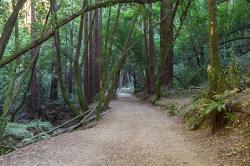
East Ridge Trail
Oakland, California
6.9 miles E of Oakland, CaliforniaThis trail is deeply tucked away up into the hills of Oakland. East Ridge is the perfect trail to deeply appreciate the beauty of the Redwoods and has many entry points. This trail weaves through grassy meadows and over ridges and steep slopes. This trail has shady parts and will lead you to the falls.
This trail on this hike is wide, even and gentle. This hike is accessible to all hikers that want to enjoy it. This trail winds steeply down to the valley floor and after rain, can be very slippery. Hikers that hike at a normal, relaxed pace, can complete this loop in about 2-3 hours. If speed is your thing, trails are equally ideal for trail running.
This hike is accessible all year round. This trail is exposed and can be pretty hot and dusty in the summer. During the rainy seasons, trails can be slippery and muddy after rain. During the winter season, keep your eye out for the massive clusters of ladybugs that migrate to the park’s trees each winter along the park’s coast redwoods.
Dogs must be leashed if you take them on this hike. The main entrance, Redwood Gate, charges a $5 parking fee during peak season. The park is opens at 5am and closes at 10pm. So if you like hiking or running at the crack-of-dawn or would prefer going after work, you can enjoy the trail and facilities.
0.5-0.6 mi
 Full Listing
Hike, Mountain Bike
Full Listing
Hike, Mountain Bike
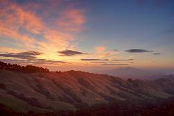
Grizzly Peak Trail
Berkeley, California
2.1 miles NE of Berkeley, CaliforniaGrizzly Peak Trail is located near La Loma Park in the Berkeley Hills section of the city of Berkeley, California and leads to an incredible lookout of the San Francisco Bay area. Driving up Grizzly Peak Road there are many spectacular places to pull over to take photos. This is a great hike to take out-of-town guests or tourists to go on, and it can be done on the way to or from Oakland/Berkeley.
Many runners have said that this trail is great for running and that the peak is a great place to stop and enjoy the view. If you choose to run to the peak and back, it would be about a 1-mile run, roundtrip. If you want to run the whole trail, it would be a little over 2 miles. This trail is dog-friendly, however, you should keep your dog on a leash. This hike is the best and most beautiful when done on a clear day, so be sure to check the weather the day before your hike.
The peak can be climbed almost year round because its elevation is relatively low. During periods of recent snowfall, it may be best to avoid the peak because of the ice and snow. Snow doesn't last too long on the peak, usually melting off most of the routes within a few days of snow. In the height of summer, temperatures may be too warm for an enjoyable climb.
The peak was named because of the Grizzly bears inhabiting the area until the late 1880s. The last grizzly in all of California was killed in the Sierra foothills east of Fresno in August 1922.
4.0 mi
 Full Listing
Hike
Full Listing
Hike
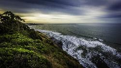
Palomarin Trail
Bolinas, California
3.7 miles NW of Bolinas, CaliforniaThis hike is about 5 miles north from Bolinas is the Palomarin Trailhead. As you hike the trail you overlook the ocean and beautiful beaches. The trail takes you up to different lakes and then ends at the beautiful Alamere Falls. Enjoy the stunning views of the pacific combined with varying terrain through forests, tall brush, and exposed dirt trails.
If you hike to falls during the summer, something great to do on your way back to the trailhead is to take a swim in Bass Lake. When you reach the path near the coast, it gets more narrow and steep. You'll often notice a little traffic jam as people figure out how to navigate their way down.
There are two steep parts when you're heading to the coast. The first steep path leads you just above the main part of the falls where you will see smaller waterfalls and the second leads you to the beach. If there are other people on the path with you, just leave room between you and them when you're headed down to the beach, just to ensure safety.
This is not a dog friendly path.
KEEP IN MIND: When you reach beach to the falls, remember that the park staff would prefer that visitors do not go to Alamere Falls itslef; it is advised that you view the falls from the beach. However, there is a "path" to the falls that is well known and can be navigated safely to get to the falls. Just remember to proceed with caution.
6.3 mi
 Full Listing
Backpack, Camp, Hike
Full Listing
Backpack, Camp, Hike
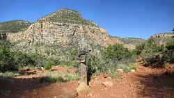
Tiyo Point Trail
North Rim, Arizona
0.5 miles N of North Rim, ArizonaThis former road is becoming increasingly overgrown by the encroaching forest. This being said, it is generally easy to follow with some blown down trees to climb over or around. There are some old trail markers nailed to trees, but you may not spot them. After an initial short ascent from the start at Point Subline Road, the trail is gently downhill over rolling terrain. Wildflowers make their home here, but they will likely be your only company on this infrequently used primitive trail. There is a single picnic area near the end of the trail. Courtesy of hikingproject.com
0.7 mi
 Full Listing
Hike
Full Listing
Hike
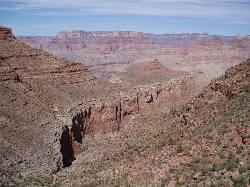
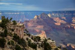
Bright Angel Point Trail
North Rim, Arizona
1.2 miles S of North Rim, ArizonaLocated at the North Rim of the Grand Canyon, the Bright Angel Point Trail is a steep, narrow, fully paved path leading to an incredible scenic viewpoint. The trail is conveniently located right next to the Grand Canyon Lodge and is only a short hike from the North Rim Visitor’s Center.
This trail encompasses stunning views from all angles and features numerous large rocks. These rocks are perfect for sitting on to relax and observe the beauty of the Canyon while also can be climbed for even more gorgeous views. The scenery constantly changes as you walk down the path and are stunning to look out upon as you return.
Keep the kiddos close as the adventure begins downhill with steep drop-offs on both sides. The steepness on the way out makes returning a bit more strenuous but is still very doable for all hiking levels. Large rocks and trees line both sides of the path for a good portion of the trail which is much less crowded than the South Rim.
Toward the end of the trail, you cross a small bridge which may seem scary, yet has guardrails conveniently placed both on the bridge as well as near the point in order to provide safety.
While the light reflecting off the Canyon appears to be flat around mid-day, Bright Angel Point is a marvelous place to watch the sunrise or sunset and experience dynamic reflections of incredible colors. The remarkable views make Bright Angel Point the most popular destination for photography at the North Rim.
×


