


Palomarin Trail
Bolinas, California
| Address: | The Palomarin Trail |
| GPS: |
37°56'3.0"N 122°44'50.3"W Maps | Directions |
| State: | California |
| Trail Length: | 9.40 miles |
| Elevation Gain: | 1460 feet |
| Trails/Routes: | 4.0 mi |
Waterfalls Trails Wildflowers Pet Friendly
Hike
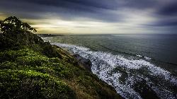
This hike is about 5 miles north from Bolinas is the Palomarin Trailhead. As you hike the trail you overlook the ocean and beautiful beaches. The trail takes you up to different lakes and then ends at the beautiful Alamere Falls. Enjoy the stunning views of the pacific combined with varying terrain through forests, tall brush, and exposed dirt trails.
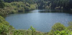
If you hike to falls during the summer, something great to do on your way back to the trailhead is to take a swim in Bass Lake. When you reach the path near the coast, it gets more narrow and steep. You'll often notice a little traffic jam as people figure out how to navigate their way down.
There are two steep parts when you're heading to the coast. The first steep path leads you just above the main part of the falls where you will see smaller waterfalls and the second leads you to the beach. If there are other people on the path with you, just leave room between you and them when you're headed down to the beach, just to ensure safety.
This is not a dog friendly path.
KEEP IN MIND: When you reach beach to the falls, remember that the park staff would prefer that visitors do not go to Alamere Falls itslef; it is advised that you view the falls from the beach. However, there is a "path" to the falls that is well known and can be navigated safely to get to the falls. Just remember to proceed with caution.
More Information
Be courteous, informed, and prepared. Read trailhead guidelines, stay on the trail, and don't feed the wildlife.
Read More- Plan Ahead and Prepare
- Travel & camp on durable surfaces
- Dispose of waste properly
- Leave what you find
- Minimize campfire impacts
- Respect wildlife
- Be considerate of other visitors
Directions
From Bolinas, California
- Head west on Wharf Rd toward Brighton Ave (43 ft)
- Continue onto Olema Bolinas Rd (0.3 mi)
- Turn left onto Mesa Rd (4.6 mi)
- Turn left (299 ft)
Take I-80 W to CA-37 W. Exit left on Atherton Avenue. Turn right on Novato Boulevard, and continue until Point-Reyes Petaluma Road. Take a left, then turn right onto Sir Francis Drake Boulevard. Turn left on CA-1 S, then take rights onto Olema Boulevard then Mesa Road. You’ll see the trailhead parking lot on your right.


Trails
Distance ?
4.0 milesElevation Gain ?
-250 feetReal Ascent ?
576 feetReal Descent ?
826 feetAvg Grade (-1°)
-1%Grade (-30° to 11°)
-59% to 19%Elevation differences are scaled for emphasis. While the numbers are accurate, the cut-away shown here is not to scale.
Other Hiking Trails Nearby
Bass Lake
Bolinas, California
1.6 miles NWHike and Swim near Bolinas, California
Hike, Swim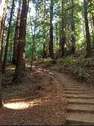
Muir Woods National Monument
Mill Valley, California
9.6 miles EThere are several suggested hikes on the main trail leaving from the visitors center. The longest, a loop, is about 2 miles. It is the only one that leaves the boardwalk. It has some elevation...
Hike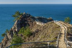
Muir Beach Overlook
Muir Beach, California
10.1 miles SEHike near Muir Beach, California
Hike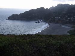
Muir Beach
Muir Beach, California
10.6 miles SEMuir Beach is a little gem nestled away in the hills North of San Francisco, not far from the Muir Woods National Monument. There's a great beach and an entire network of trails. To get to the...
Hike, Swim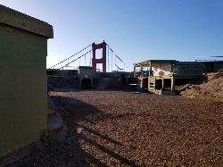
Battery Spencer
Mill Valley, California
16.1 miles SEThis is easily one of the best places to view the Golden Gate Bridge. For over half a century, this was one of the most strategically important sites guarding the Golden Gate. Completed in 1897,...
Hike
Auburn Area
San Francisco, California
19.7 miles SEAlongside of the North Fork of the American River in the Auburn State Recreation Area, there are several swimming holes. Located at Emigrant Gap in the Tahoe National Forest, the North...
Hike, Horseback, Kayak, Rock Climb, Swim, Whitewater 0.1-0.6 mi
Mt. Sutro Open Space Reserve
San Francisco, California
20.0 miles SEMount Sutro Open Space Reserve is a 61-acre ecological oasis in the heart of San Francisco, just south of UCSF's Parnassus Heights campus. UCSF is committed to maintaining the Reserve as a safe...
Hike, Mountain Bike 0.5-0.6 mi
Grizzly Peak Trail
Berkeley, California
28.0 miles EGrizzly Peak Trail is located near La Loma Park in the Berkeley Hills section of the city of Berkeley, California and leads to an incredible lookout of the San Francisco Bay area....
Hike, Mountain Bike 3.7 mi
East Ridge Trail
Oakland, California
34.2 miles EThis trail is deeply tucked away up into the hills of Oakland. East Ridge is the perfect trail to deeply appreciate the beauty of the Redwoods and has many entry points. This trail weaves...
Hike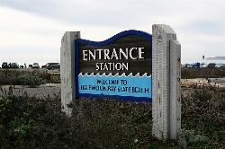
Half Moon Bay State Beach
Half Moon Bay, California
36.2 miles SEHalf Moon Bay State Park's Coastside Trail runs parallel to the Pacific Coast along what used to be the Ocean Shore Railroad. The railroad itself was in operation for just 14 years before it was...
Camp, Hike, Horseback, Swim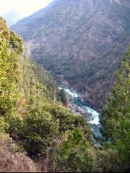
Willow Creek Environmental Campground
Duncans Mills, California
40.1 miles NWWillow Creek campground is located along the sandy banks of the Russian River. It offers a beautiful sandy beach like terrain along the edges of the river, and unmatched river views....
Hike, Kayak, Swim


