


34 locations
Add Location
 Full Listing
Show more
Skateboard
Full Listing
Show more
Skateboard
Powell Skate Park
Powell, Ohio
0.4 miles N of Powell, OhioThe Powell Skate Park is a spacious public concrete skatepark in the city of Powell, Ohio, in the northern suburbs of Columbus. At around 17,000 square feet, it's a generously sized park with a good spread of terrain, and a popular gathering spot for the local skateboarding community.
The layout offers a fun variety of features to session, including banks, ledges, and hips, along with a bowl finished with pool coping, a road-barrier feature, and a bumpy flow section that adds some character to your lines. That mix of street and transition terrain gives skaters of different levels plenty to work with, from learning the basics to linking together longer runs. Note that this is a skateboard-focused park — bikes are not permitted.
The park sits next to Village Green Park, a more traditional green space with playgrounds, walking paths, mature shade trees, and room to picnic — making it easy for families to relax while others skate. As a free public facility, it's an accessible and welcoming place to ride. As always, gear up with a helmet and pads (especially younger skaters), be courteous and take turns, bring water, and check for any posted hours or rules. Roomy and well-rounded, the Powell Skate Park is a great spot in the Columbus area.
0.9 mi
 Full Listing
Show more
Hike, Mountain Bike
Full Listing
Show more
Hike, Mountain Bike
Ruth Hamilton Trail
Phoenix, Arizona
7.7 miles NE of Phoenix, ArizonaThe Ruth Hamilton Trail (Trail #8B) is a short but rewarding hike in the Phoenix Mountains Preserve, in the popular Piestewa Peak and Dreamy Draw area right in the heart of the city. Named for one of the advocates who helped make the preserve possible, it's a local favorite for a quick desert workout with an outsized payoff in views.
From its trailhead the path climbs by way of rocky switchbacks to a saddle, where it meets the Quartz Ridge Trail at a well-placed observation bench — a fine spot to catch your breath and take in the sweeping panorama of the downtown Phoenix skyline and the northern Sonoran mountains. From there it rolls over another ridge and descends toward the Nature Trail on the east side of Piestewa Peak.
Though short, it's moderately rocky and gets busy, and savvy locals link it with neighboring trails (200, 202, 8A, and the 304 Nature Trail) to piece together longer loops through the preserve.
This is exposed Sonoran Desert with little shade, so summer hikers should go at dawn or dusk and carry plenty of water. Watch for other hikers and cyclists, wear real trail shoes for the rocky tread, and enjoy one of the city's handiest escapes into the hills.
2.3 mi
 Full Listing
Show more
Mountain Bike
Full Listing
Show more
Mountain Bike
Cove Creek
Canton, North Carolina
15.7 miles S of Canton, North CarolinaAll the climbing is on gravel forest roads. Then you descend on Cove Creek Trail. There are some cool rock sections up at the top and a few rustic log bridges about mid way down but overall this is a fast and very fun decent. Courtesy of pisgahareasorba.org
Stay left for a gradual climb that becomes nice long super technical. Just at the highest point turn left on to the connector to Cove Creek Rd, some fast rolling single track on the grown over road leads to a gravel road. Look for the well marked trail head to the Cove Creek trail and enjoy the mostly down hill fast and furious single track. Most of the creek crossings have new bridges as of this writing, with a few old log walking bridges still there. Courtesy of singletracks.com
0.6 mi
 Full Listing
Show more
Hike, Horseback, Mountain Bike
Full Listing
Show more
Hike, Horseback, Mountain Bike
Horseshoe Trail
Scottsdale, Arizona
11.7 miles N of Scottsdale, ArizonaHorseshoe trail is a short, fun singletrack with a lot of quick turns created by wash areas and rocks. It's a nice warm-up heading to Gateway Loop Trail. In some areas there are a lot of cactus, so have your turns down and be careful. It's great practice for beginner-intermediate riders. Hikers are rare. However, I have seen a lot of wildlife ranging from tons of javelina during all seasons, white tailed deer during the colder months, and even a couple of bobcats. Enjoy! Courtesy of mtbproject.com
8.3 mi
 Full Listing
Show more
Hike, Horseback, Mountain Bike
Full Listing
Show more
Hike, Horseback, Mountain Bike
Estrella Mountains Competitive Track
Tolleson, Arizona
6.6 miles SW of Tolleson, ArizonaThe third competitive track in the Maricopa County Regional Park system, located in Estrella Mountain Regional Park, was completed in February 2000. The track consists of two loops totaling 13 miles. The long loop is 8 miles and is challenging, but may be used by persons of all skill levels. The technical loop is 5 miles and is recommended for experts only. All of the competitive tracks are primarily used by Mountain Bicyclists, but are also used from time-to-time by cross country runners and “endurance” horse riders. The tracks are designed for high speeds, racing events and fun. They feature steep climbs, and drops, fast corners, twists and turns and rugged rocky terrain. Courtesy of mountainbikeaz.com
12.6 mi
 Full Listing
Show more
Hike, Mountain Bike
Full Listing
Show more
Hike, Mountain Bike
National Trail
Phoenix, Arizona
9.1 miles SW of Phoenix, ArizonaNational Trail is the gem of South Mountain and home to the infamous Waterfall. It’s a local favorite as well as a destination trail for MTB snowbirds. Courtesy of mtbikeaz.com
Like most trails in the Sonoran Desert, you'll find bursage, brittlebush, creosote cush, palo verde trees and saguaro cactus. More than 300 species of plant life are found in the park. The park is also abundant with wildlife - rock squirrels, desert tortoises, chuckwallas, great horned owls, rattlesnakes, coyotes and red tailed hawks to name a few. There are petroglyphs hidden throughout the range, courtesy of the Hohokam Indians. Courtesy of hikearizona.com
National then takes you over Telegraph pass and up to the Buena Vista Lookout. From the Buena Vista lookout to the end of National at the east end, it gets more technical with bigger technical features and rock moves. Some of the areas Downhillers will shuttle up to Buena Vista Lookout and ride this section of National. It is an enjoyable section of trail as long as you know your limits and walk features above your current ability levelCourtesy of mtbproject.com
1.0-1.2 mi
Full Listing
Show more
Hike, Rock Climb
Camelback Mountain
Phoenix, Arizona
7.7 miles NE of Phoenix, ArizonaHiking
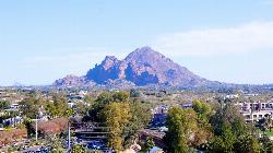
After Camelback became a park in 1968, TripAdvisor advertised the hikes as one of the top 10 things to do when in Phoenix. Located right in the middle of Phoenix, Scottsdale and Paradise Valley, Camelback Mountain is a hike that both locals and tourists enjoy regularly. Camelback Mountain has 2 primary trails that hike to the summit, and both offer fantastic views of the valley and of the many species of flora, including a few different types of cactus.
- Echo Canyon Trail: Echo Canyon trail is the steeper of the 2 trails up Camelback, although slightly shorter at 1.23mi to the summit. This trail is well-managed but steep and is a great challenge for hikers, taking 2-3 hours round trip, depending on the pace. The phenominal views along the way make the hike well worth the challenge. For this trail, parking is available at the Echo Canyon Recreation Area, but very limited on the weekends after 7am, so plan accordingly. Unfortunately , the parking is only available dawn to dusk, so don't plan on hiking for any sunrises or sunsets on the summit. Spectacular views of the sunrise and sunset can be seen along the trail, however, which is okay as long as you obey the parking hours.
- Cholla Trail: Cholla trail is longer than Echo Canyon at 1.4mi but is a little easier for those still eager for a refreshing workout outside without too much huffing and puffing. The first mile hikes on a fairly maintained trail and the second mile or so gets a little steeper and may require intense hiking and scrambling. Along the Cholla trail, there will likely be some of Arizona's wildlife posing for pictures if hikers are quiet. Popular creatures include hawks, road runners, chuckwallas, harris antelope squirrels, and quail. Rattlesnakes are also common on the trail, so be alert. Parking for this trail is available all along Invergordon Road (64th St) and a walk to the trailhead, resulting in less limited space and more flexible hours than at Echo Canyon
Climbing
The climbing at Camelback mountain has a particular style loaded with easier climbing, sparse protection, and falling rock. There are still a few classics that both locals and visitors can enjoy on the "petrified mud" that is desert climbing. There are 42 total climbing routes spread over 11 areas, making up 5 boulders, 24 sport routes, 11 trad routes, and 1 Top-rope. Of these climbs, the majority are in the 5.6 or easier range with 17 or so moving into the moderate 5.8-easy 5.11 range. One of the classics at the crag is Chimera on Gargoyle Wall, a 2-pitch 5.9 PG-13 sport route worth 4 stars.
Parking for climbing at Camelback mountain is available at the Echo Canyon Recreation Area lot or on Invergordon Road (64th St) on the other side of the mountain
3.7 mi
 Full Listing
Show more
Mountain Bike
Full Listing
Show more
Mountain Bike
Bradley Creek Road
Horse Shoe, North Carolina
7.5 miles NW of Horse Shoe, North CarolinaThis graded FS road gradually ascends from the Bradley Creek Trail (#351) on its way to Yellow Gap Road. Enjoy the surrounding hardwood forest as you climb - the road itself is not too exciting to ride. Courtesy of mtbproject.com
This is a gated forest service road that mostly descends for 4 miles from FS 1206 to a junction with several singletrack trails. Fairly smooth, but lots of climbing from the other direction. Courtesy of singletracks.com
13.5 mi
 Full Listing
Show more
Mountain Bike
Full Listing
Show more
Mountain Bike
Horse Cove Gap Loop / FS 475C
Brevard, North Carolina
4.8 miles NW of Brevard, North CarolinaMaintained fire road. From the hatchery, it's 4 miles of steady elevation gain before easing and connecting to Bracken Mt. Trail. GPS map is 5.8 miles one-way, 12 miles round trip. Otherwise, connect to other trails in the area to form a bigger loop. Courtesy of Singletracks.com
This loop opens with a four-mile road climb (most of which is gated off to cars) to reach some fun technical descents on Horse Cove Gap Trail #325 before continuing on the more gradual Squirrel Gap Trail (#147). The loop is less difficult than other other Pisgah descents, but still works in some challenging sections without forcing riders off big drops or jumps. It's a little more secluded and has many pretty views of the Parkway, Looking Glass Rock, and South Mills River. Courtesy of mtbproject.com
This ride begins with a forest road climb and views that rival any in Pisgah—just make sure you look over your shoulder on the way up. You’ll easily spot Pilot Rock and Slate Rock hanging on the mountainsides below the Blue Ridge Parkway. The single track that follows is as great as the scenery. Ride surface is 7.9 miles of single track and 4.3 miles of forest road. The hightlights include stunning views, technical single track, a swinging bridge, South Mills River, and fun downhillsCourtesy of trails.com
7.1 mi
 Full Listing
Show more
Hike, Mountain Bike
Full Listing
Show more
Hike, Mountain Bike
Daniel Ridge Loop
Canton, North Carolina
17.1 miles S of Canton, North CarolinaThis is a classic, short Pisgah loop. It's moderately technical most of the way with a couple of trickier sections. Most people prefer to approach it counter-clockwise, but it can be ridden either way. Now it's downhill for a while... great rocky downhill roller coaster that is technical enough to command your attention. Then you'll make a sharp left at some log steps where it intersects Farlow Gap trail. The descent mellows out at some forested track that brings you back to the river. Courtesy of mtbproject.com
There are several loops that can be done but this is my favorite: Follow the gravel doubletrack until it forks, and take the right path. Wind your way up and up, past two waterfalls, until you reach where the trail intersects the gravel road. Go left (and down!) and follow this back to the first waterfall and then ride out. Courtesy of singletracks.com
1.5 mi
 Full Listing
Show more
Hike, Horseback, Mountain Bike
Full Listing
Show more
Hike, Horseback, Mountain Bike
Moon Rock Loop
Apache Junction, Arizona
5.1 miles NW of Apache Junction, ArizonaLocated within the larger Usery Mountain Regional Park, the Moon Rock loop is a fast and smooth trail that adds 1.3 miles to the more famous Blevins Trail. Although the Moon Rock loop is not known as well, it is still a classic in the Usery area, featuring pavement-smooth doubletrack and flowy turns to make riders of all skill levels smile. The best feature about Moon Rock loop is that the trail is mostly turned downhill, allowing riders to go as fast as they can pedal without burning out. The trail is a doubletrack, meaning it is wide enough for mountain bikers and small groups of hikers, so be careful and watch out for others coming either direction in the loop.
Because Moon Rock loop is part of the larger system in the Usery Mountain Regional Park, there is no direct access to the trail. Instead, there is 1 parking area and 2 ride-in entrances (all are located on the map below).
From the parking area, follow the Blevin's trail on the right for about a 1/2 mile to the Moon Rock loop sign that will be on the right. Riders and hikers can also stay on Blevin's trail for another 1/2 mile and ride the Moon Loop clock-wise. To get back to the parking area for both paths, just turn left at the sign that marks the connection to Blevin's and ride the 1 mile back.
From ride-in entrance #2 on the map below, turn left onto the Levee trail and ride until the intersection with the Moon Rock loop. Riders can either turn left onto the loop or turn right, turn left onto the Blevin's trail, then turn right again at the other Moon Rock loop entrance. Both ride-in entrances have a kiosk for a self-pay $2 entry.
The Moon Rock Loop does not feature any particular viewing areas, but allows riders and hikers to experience the desert at it's best, with plenty of the southwest plant and animal life among the thrilling twists and turns of smooth arizona dirt.
1.7 mi
 Full Listing
Show more
Hike, Horseback, Mountain Bike
Full Listing
Show more
Hike, Horseback, Mountain Bike
Levee Trail
Mesa, Arizona
12.8 miles E of Mesa, ArizonaLocated within the Usery Mountain Regional Park, the Levee trail is named so because it mostly follows the top of levee, running parallel to a large section of the channel trail and a Phoenix Subdivision. This trail is very smooth, very flat double track, making for an excellent cross-country ride or run and a great connector to get to other trails in the Usery Mountain Regional Park. Whatever the means of travel, be cautious of riders, hikers, and the occasional horse-back rider as all are allowed on the trail.
To get to the Levee trail, there is 1 parking area and 2 ride-in entrances (all are located on the map below).
To get to Levee from the parking area will require about a mile of additional riding, but this is the easiest way to include the full 1.6mi of Levee trail. Once at the parking area, turn right onto the Blevin's trail and follow until the Moon Rock Loop sign on the right. Turn right, and soon there will be a Levee sign on the left.
Both ride-in entrances allow direct access onto the Levee trail, but require a $2 entrance fee at the self-pay kiosks located there.
To get back to the original starting point, either turn around and ride back directly the way you came, or connect to any of the trails in the area to create a loop and longer ride on the same smooth double-track.
4.6 mi
 Full Listing
Show more
Mountain Bike
Full Listing
Show more
Mountain Bike
Mystery Loop
Phoenix, Arizona
9.5 miles NE of Phoenix, ArizonaThe trail is a nice combination of technical rock trail, washes, and climbs. There is a large network of trails to make the ride longer or shorter depending upon your needs. These trails cross over Trail 100 which allows for lots of other options. Courtesy of Singletracks.com
This is a pleasant loop hike in the northern end of the Phoenix Mountain Preserve. It includes several unnamed trails as well as parts of the Christiansen, Perl Charles and Irregular Link trailsCourtesy of hikearizona.com
7.5 mi
 Full Listing
Show more
Hike, Mountain Bike
Full Listing
Show more
Hike, Mountain Bike
Hawe's Loop
Mesa, Arizona
10.6 miles NE of Mesa, ArizonaMost of the trails in the Phoenix metropolitan area were originally built by mountain bikers, and the Hawe's loop trail system and trail are no exeptions. This trail features fantastic singletrack that twists and turns for miles. Be warned, as this trail is in the desert and features many desert hazards such as heat and dangerous desert creatures. The trail is well maintained, but there are plenty of cacti next to the trail as it twists and turns that won't play nice with your feet or legs if you ride too close.
Hawes loop is one of the less rocky trails in the area, so this is a great place for riders looking for speed and flow, or looking for an endurance ride with multiple laps, and with beautiful views of nearby Red (McDowell) mountain, Salt River, and the desert scenery it will be hard to only ride around once!
The trail is full of loose desert rocks and dirt and is mostly downhill, so prepare for a lot of loose braking. If the same loop is ridden in reverse it is a lung-busting endurance ride with lots of climbing.
There are a couple different options to get to the Hawe's loop trail:
1) Park behing the Walgreens at the intersection of N Power Rd and E Thomas Rd. From there, pedal across N Power Rd just past the canal and access road. Just before the Las Sendas sign, the Fenceline Trail turns left behind the houses. This trail is 1.1mi of beginner singletrack that can often be ridden at high speeds. There may be riders traveling the other way doing the same, so be aware of others. Once the trail intersects with Hawe's trail (a separate black diamond ride), keep left to stay on Hawe's loop. The trail will fork again after 0.3mi and the official loop continues to the right.
2) Park at the Canal lot further North on N Bush Hwy, ride 0.3mi along the road, and enter the Hawe's loop via the signs. This option cuts off the 1.1mi of the Fenceline trail both ways.
For both options, there is a shortcut about 1/3 of the way through the loop. Shortly after the Hawe's loop connects with the Upper Ridge trail, there will be a left-hand turn that will cut off a medium-sized additional loop. So take the left turn if a slightly shorter ride is desired.
1.5 mi
 Full Listing
Show more
Hike, Mountain Bike
Full Listing
Show more
Hike, Mountain Bike
Desert Classic
Phoenix, Arizona
7.8 miles SE of Phoenix, ArizonaThe Desert Classic trail is just that, a classic at the South Mountain Park area. Because it is such a classic, the trail is well marked and well worn by high traffic flow of riders and hikers. The trail travels north or south for 9 miles depending on where the starting point is, then turns around at the end for another 9 miles, creating an out & back trail on hardpacked sand, some sandy washes, and small chunky rocks.
There are a few different ways to ride the DC trail: 1). Park at the Prima Canyon parking area, keep the mountains on your right and ride south. Shortly after leaving the parking area there is a map with the DC trail well-marked on it. Follow the signs for the DC trail and keep left as you pass the Marcos De Niza Trail. The trail ends at a junction with Telegraph Pass Trail, turning around and following itself back for 9 miles, creating the out & back. 2). Park at the Desert Foothills parking area and ride towards the mountain. Keep right as you pass the Telegraph Pass Trail, then ride for 9 miles keep the mountain on your left and following the DC trail markers. 3) Park at either of the parking areas and shuttle a car to the other parking area, making the trail only 9 miles of singletrack instead of the 17 mile out & back.
Because it is a multi-purpose trail, always be cautious of hikers and other riders.
This trail is without a doubt the easiest and least technical ride in South Mountain Park. Crossing the many small washes that run down from the mountain adds some interest and fun without much difficulty. Courtesy of mtbproject.com
Whether the trail is easy or not all depends on your fitness and skill. Yes, this trail is a piece of cake, compared to National, but it’s still fun, fast and furious and a singlespeeder’s hammerfest. Courtesy of mtbikeaz.com
4.5-5.0 mi
 Full Listing
Show more
Mountain Bike
Full Listing
Show more
Mountain Bike
Kitsuma Mountain Bike Trail
Old Fort, North Carolina
5.1 miles W of Old Fort, North CarolinaKitsuma Trail is an absolute classic in the Pisgah National Forest area, so classic in fact that Litespeed Bicycles named one of their old Hardtails after the trail.
After a short road ride to the trailhead from the parking area, the "intermediate" grade of Kitsuma is clear as soon as you start on the first switchback. Better find your climbing gears! After 1,000 feet of elevation gain in 12+ brutal switchbacks and close to 3 miles, your thighs will thank you as you near Kitsuma Peak-the summit of the trail. As you ride along a mellow ridge at the summit, the beautiful views of Mt. Mitchell and thick North Carolina forest offer some momentary relief from the climbing before starting down the lightning fast descent.
Though the climbing to the peak is difficult, the iconic 2.8 miles of descent towards the Old Fort picnic area allow ferocious speeds on unbelievably fast and flowy singletrack. The flow of the trail is accented with a healthy number of big berms, drops, and some rolling jumps that let you enjoy and play on your bike to the fullest. There are a handful of tighter corners on the downhill, so stay loose and prepare for these or you will shoot headfirst into the North Carolina brush. The trail and especially the descent are best ridden dry. The well-worn dirt on Kitsuma offers fantastic grip if you're riding sticky tires, but the trail and roots can also be on the loose side of things when wet or covered with leaves.
After resting and regaining the feeling in your face at the Old Fort picnic area, ride left onto Old US-70 and take the next left turn onto a paved road. Follow this road for 5 miles over some easy climbing back to the Kitsuma trailhead, rest for a bit more, then ride it again!
2.2 mi

Full Listing
Show more
Hike, Horseback, Mountain Bike, Rock Climb
Marcus Landslide Trail
Scottsdale, Arizona
15.6 miles NE of Scottsdale, ArizonaThe Marcus Landslide Trail is named after ASU professor Melvin Marcus, a renouned geographer, after the discovery and recognition of the interesting geographical area in 2002. More than 500,000 years ago, catastrophic events led to the landslide in the McDowell Mountains that has created beautiful formations for the hikers, bikers, and climbers to behold.
Experts believe some of the native plants and animals of the time are buried underneath the landslide including mammoths, giant sloths, saber-tooth cats, camels, and horses. Courtesy of hikearizona.com
The Tom's Thumb Trailhead is the starting point for the Marcus Landslide Trail, which is heavily marked and worn-down by many hikers and riders over the years. The trail is wide and very smooth, which is great to allow plenty of views at the eye-catching boulder and rock features. On a clear day, one can see the Superstition and Mazatzal mountains on the horizon. There is little elevation gain for the first mile or so of trail, but it eventually climbs up into the landslide areas. Some of these avalanche landmarks include the breakaway scar, the fall zone, and the slide mass edges.
Hiking, mountain biking, and horseback riding
Start at the Tom's Thumb parking area and trailhead and turn left, following the signs for the Marcus Landslide trail. Follow this trail for 1.5 miles until it connects with the Boulder trail. At the fork, turn right and follow the loop around, ending at the fork once again. Follow the trail for the 1.5 miles back to the parking area.
Rock Climbing
Start at the Tom's Thumb parking area and hike along the Marcus Landslide trail. Access trails to the climbing areas are found all along the trail at varying distances with the closest at 0.3 miles in. The nearby climbing in the McDowell Mountains offers 125 total climbing routes, 96 of which are trad. The local climbing ethos celebrates stiff ratings, including run-outs, on varying quality granite depending on the specific crag. The climbing ranges from 5.4 to moderate 5.11, both trad and sport, so there are routes to enjoy by climbers of all skill level and pursuit. Some of the classics include Changes in Longitude at 5.5 trad and 150ft in 2 pitches and Leave it to Beaver at 5.9 trad and 90ft.
Once threatened by house and golf course development, the city of Scottsdale (with the help of it's citizens, who kept voting in tax $$ support to acquire the land!) managed to turn the whole place into the McDowell-Sonoran Preserve, starting in the mid 90's and continuing to this day. The Preserve today sits at almost 22,000 acres with the eventual plan to encompass some 36,000+ acres! Courtesy of mountainproject.com
To keep climbing access, rememeber to stay on developed trails and keep the crags clean.
1.0 mi
 Full Listing
Show more
Hike, Horseback, Mountain Bike
Full Listing
Show more
Hike, Horseback, Mountain Bike
Quail Trail
Goodyear, Arizona
3.9 miles S of Goodyear, ArizonaQuail Trail is the access trail from the Nature Center to the main trail system. It is a pretty steep climb, but smooth and steady. Courtesy of trailforks.com
Quail Trail is a spur trail in the Estrella Mountain Regional Park. It connects the Nature Center trailhead to the Baseline Trail. Quail Trail is a spur trail in the Estrella Mountain Regional Park. It connects the Nature Center trailhead to the Baseline Trail. $6 entry fee per car. Courtesy of AllTrails.com
3.6 mi
 Full Listing
Show more
Hike, Horseback, Mountain Bike
Full Listing
Show more
Hike, Horseback, Mountain Bike
Toothaker Trail
Goodyear, Arizona
4.6 miles S of Goodyear, ArizonaToothaker is an easy roller coaster of a trail. It crosses numerous washes ranging from small to large and can be a tad loose and/or rocky in some sections. The end reward is a nice view of Rainbow Valley and the westernmost peaks of the Sierra Estrella mountain. Courtesy of hikearizona.com
Located on the extreme western edge of the Phoenix Metro Area, the Estrella Mountain Regional Park offers a unique hiking experience in that it's conveniently located to the city yet still relatively secluded. The park is perhaps one of the most unique county parks in that it offers large stretches of grass for picnics, a rodeo arena, and several interconnected trails, which allows visitors to customize their hike to practically any length and ability level. Courtesy of hikingarizona.blogspot.com
2.9 mi
 Full Listing
Show more
Hike, Horseback, Mountain Bike
Full Listing
Show more
Hike, Horseback, Mountain Bike
Coldwater Trail
Goodyear, Arizona
4.5 miles S of Goodyear, ArizonaThe Cold Water Trail #27 is a seldom visited, remote backcountry destination along the backdrop of the rugged Verde Rim with healthy mixed vegetation and unique geology. The trail was originally used by army troops traveling from Fort McDowell to Camp Verde. Courtesy of hikearizona.com
×


